
-
 3469 Hits
-
 79.04% Score
-
 10 Votes
|
|
Mountain/Rock |
|---|---|
|
|
38.92185°N / 78.74427°W |
|
|
Shenandoah |
|
|
3219 ft / 981 m |
|
|
Overview
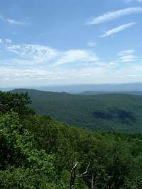
Great North Mountain is located on the border between Virginia and West Virginia. It runs mostly from northeast to southwest, but after Tibbet Knob, it makes a sharp turn directly to the north. After a couple of miles, it makes another sharp turn to the southwest. At the turn, there are three peaks on Great North Mountain from northeast to southwest, which are Devils Hole Mountain, Devils Benchmark, and Point 3219.Although it has a fairly well-known hike that passes over its summit and an overlook with spectacular views of the Shenandoah Valley and several mountain ranges, Point 3219 itself remains relatively obscure. It is not even listed in the fantastic mountain database Lists of John. Given its namelessness and the lack of even an exact elevation on the UGSS topo map, the fact that my GPS nailed its elevation at 3,219 feet makes Point 3219 just as good a name as anything else.
Getting There
Laurel Run Trail: From Woodstock, go south on Route 42 until reaching SR 675. Turn right and follow SR 675 to SR 717, which is Liberty Furnace Road. At Liberty Furnace, turn right on SR 691. After 0.4 miles, turn left on FR 252 and follow it for 1.5 miles to the locked gate. Just before the culvert in front of the gate, there is parking on the left.Turn left on the orange-blazed Great North Mountain trail and follow it for 0.5 miles to the first summit of Point 3219. The summit is not terribly interesting; it just looks like a point in the woods after which the trail goes down instead of up. Continue for 0.1 miles beyond the summit, where you will see a rock cairn on your left. Turn and follow a side trail to Wil’s Point Overlook.
It is highly likely that the first summit is the true summit of Point 3219, but if you really want to make sure, the second summit is a large pile of rocks to the right of the trail. Its coordinates are 38.92185 N, 78.74427 W. The third summit is to the left of the trail and is less interesting than the first summit. Its coordinates are 38.92137 N, 78.74472 W.
Round trip: 7.8 miles with an elevation gain of more than 1,700 feet.
 Rhododendrons |  Purple Flowers |  Mushroom |
Great North Mountain Trail: From Woodstock, go south on Route 42 until reaching SR 675. Turn right and follow SR 675 to SR 789, where you make a left. After 0.3 miles, turn right onto SR 691, and follow it for 4.9 miles until reaching a parking area on the left. After getting out of the car, continue for about 0.1 on SR 691 until reaching the Great North Mountain Trail on the left. Follow the Great North Mountain Trail for 0.5 miles to the summit and then an additional 0.1 miles to Wil’s Point Overlook.
Round trip: 1.4 miles with an elevation gain of about 250 feet.
 Tibbet Knob |  Great North Mountain |  Shenandoah Mountain |
Red Tape
Point 3219 and the routes to its summit are on public land in the George Washington National Forest. There are no fees or permits required for hiking or camping. Please respect private property near the Laurel Run trailhead on the left side.Camping
Free camping is permitted throughout the George Washington National Forest except in the immediate vicinity of picnic areas and a few other locations. There is a campground near the parking area on the left side just before the culvert at the Laurel Run trailhead and another campground on the right shortly after the start of the trail.Other campsites can be found in a grassy area about 2.1 miles from the trailead.
When to Climb
Point 3219 can be climbed nearly all year round. The hike can be particularly delightful from mid-October through mid-November because of the autumn colors. July and August are the worst months for heat, humidity, haze that limits views, and hostile little critters like ticks, yellowjackets, and mosquitoes. The best time for a summer hike is early in the morning. The upside to hiking in early July is seeing the rhododendrons on the first mile of the trail.Hiking should be avoided in the National Forest when it is permissible to hunt deer with modern firearms. In 2017, deer season runs from November 18 through December 2. In West Virginia, deer season runs from
External Links
George Washington National Forest- Lee Ranger DistrictThe Potomac Appalachian Trail Club maintains the trails on Great North Mountain, and provides maps, guidebooks, and other information.