
-
 4894 Hits
-
 85.36% Score
-
 20 Votes
|
|
Mountain/Rock |
|---|---|
|
|
34.49403°N / 119.71268°W |
|
|
Santa Barbara |
|
|
Sport Climbing, Toprope |
|
|
Spring, Summer, Fall, Winter |
|
|
3890 ft / 1186 m |
|
|
Overview
In terms of altitude, Earth Watch is the highest rock formation on the Camino Cielo Ridge. It’s located only 150 feet down from the summit of La Cumbre Peak, just under 4000 feet.
 Jumpin Jive Boulder
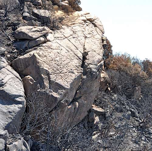
This overhanging rock had been noticed by climbers for decades, but no attempt was made to establish any climbs on it. This lack of interest and inactivity may have been due to the distance from Santa Barbara, or the fact that there were so many other formations to keep the local climbers busy for decades. In the early 1990s a new and ambitious group of climbers came onto the scene. I affectionately called them “The 5.13 Club.” The 5.13 club members did not pass up a chance to bolt, and in a few cases, chip and glue holds onto any steep face you could walk to. Earth Watch, being both steep and overhanging, filled the 5.13 club’s ambitions, at least for a while.
Within a few weeks five possible routes were bolted and most of them were red poited. There was, however, one exception. The right hand line of bolts, as far as I know, was never done on lead. Possible rating for this climb, 5.13b. By the time the rest of us peons were alerted to the new area, the 5.13 club had moved on to other blank faces to chip and glue.
 |  |  |  |
Routes of Earth Watch

Expecting to see a lot of drilled pockets, I visited Earth Watch in 1994. Much to my surprise, I found very little evidence of doctored holds. I did, however, find a great formation to get strong on. The climbs are short and easy to top rope. Most people climb the overhanging two thirds and lower off of the last bolt on the lip of the overhang. Climbing the upper part, which is very slabby, can be very rough on the rope if you are top roping or lowering off. If you are leading the climb, it’s much better to rappel down, as opposed to lowering off.
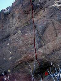

To get to the base of Earth Watch, you can either rappel from the top or down climb an easy fifth class chimney. There is also a so called third class section on the right, as you look down from the top, that can be used. I have never used this option and cannot testify to its feasibility.
The best way, however, is using the two bolt anchors on top to rappel down and leave your rope there to belay up the exit chimney on the way out.
The climbs themselves get progressively difficult from left to right. The easiest climb on the formation is called “ Clubbing Baby Seals, 10b” protected by four bolts. The most saught after climb on Earth Watch is “Project Earth Watch, 11a” also protected by four bolts.
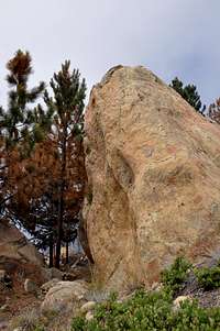
If you are in the mood for high-ball bouldering, there is a 17 foot boulder on the top of La Cumbre Peak with at least one 5.10 climb on it. The climb is called Jumpin Jive.
| Climbs of Earth Watch | |
| A | Clubbing Baby Seals, 10b, 4 bolts to the lip of the overhang |
| B | Project Earth Watch, 11a, 4 bolts to the lip of the overhang |
| C | Manhattan Project, 11a, 4 bolts to the a double bolt anchor on the lip of the overhang |
| D | Smear The Queer, 12b, 4 bolts to the lip of the overhang |
| E | Project, don't let the looks fool you. It's overhanging with very few holds. |
Camping
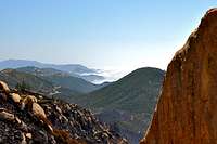
 Looking west from Earth Watch
Unfortunately, there are no campgrounds close and convenient to Earth Watch.
There is, however, one very large and well developed campground at Cachuma Lake, and a few less developed ones along Paradise Road off Highway 154. There are also a few campgrounds along Highway 101 at El Capitan State Park and Refugio State Park.
El Capitan Beach Camping
Refugio State Beach Camping
Cachuma Lake
How to get there

From Highway 101 take the Las Positas off ramp. For those coming from the south turn right; for those coming from the north turn left. In either case, drive toward the mountains to the north of Santa Barbara. Continue up Las Positas for .85 miles to State Street, where the name of Las Positas changes to San Roque. Continue driving straight toward the mountains until you come to HWY 192 (Foothill Road) in another .5 mile. Turn right at the intersection and continue up Foothill Road for 1.9 miles to its intersection with Mountain Drive. Turn left onto Mountain Drive and drive for .5 mile to its intersection with Gibraltar Road. Gibralatr Rock is about five miles from this point. You will recognize Gibraltar Rock located to the west of the road when you begin to see a large sandstone formation immediately to your right (east side of the road). This formation is “The Bolt Ladder.” Gibraltar Rock is a little further up the road and to your left.
Drive another two miles further up Gibraltar Road to its intersection with East Camino Cielo Road. From here continue another 1.8 miles to where Comino Cielo Road becomes level. There are many pine trees and a gate. Park your car by the side of the road and walk about ten minutes past the gate to the top of La Cumbre Peak. From the top of La Cumbre Peak drop down about 150 feet on a faint path to the top of the formation. There are two welded cold shuts for rappleing. You can also scramble through Manzanita bushes to the east of the formation and circle around to the base.