
|
|
Mountain/Rock |
|---|---|
|
|
51.90280°N / 5.31277°W |
|
|
Pembrokeshire |
|
|
Trad Climbing, Toprope, Bouldering |
|
|
Spring, Summer, Fall, Winter |
|
|
164 ft / 50 m |
|
|
Overview
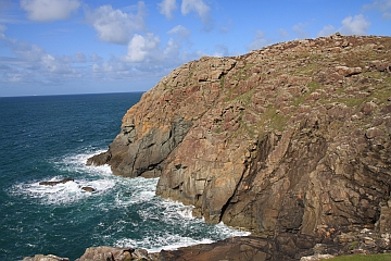
For me St. David’s Head, or Penmaen Dewi in Welsh, epitomises all that is great about Wales’ coastal heritage – a far westerly location, a steep and ancient cliff line, secluded golden bays, wild heather-clad hillsides, and the timeless edifices of an immemorial past. For the climber it also offers something special – clean and solid rock, a variety of route types, a mixture of tidal and non-tidal stances, and of course, those iconic surroundings. |


The rock climbing is split unevenly over the different parts of the headland, all of which follows the traditional style, and all of which encapsulate a rare feeling of exploratory zest. The most frequented crag is the South Face, which although non-tidal, only just sits above the high tide mark, and is probably best avoided when the weather is particularly boisterous. It does however, house a good collection of easy to mid grade routes. The headland’s second crag is the North Buttress, a compact piece of rock with a handful of mid to hard grade routes. The next crag worth mentioning is Craig y Crisial, which is tidal, and is home to routes of a more challenging nature. St. David’s Head’s remaining routes are technically unrecorded, although they have each no doubt been climbed many times over. My best advice is to just pick a line that looks good and climb it. |
The Legend of Saint David
 St. David's Cathedral (Photo by Nanuls) St. David's Cathedral (Photo by Nanuls)Those already familiar with Pembroke will know that this headland is named after local boy and patron saint of Wales, Saint David. David, or Dewi as he is known in Welsh, was born in around 500AD, possibly to the then king of Ceredigion, but possibly not. According to legend, David was conceived through violence and his mother gave birth to him on a cliff top during a violent storm. He was probably educated at Whitland in Carmarthenshire under Saint Paulinus of Wales and was baptised by St. Ailbe. He travelled widely, and became renowned as a teacher and preacher, founding monastic settlements and churches in Wales, Cornwall and Brittany in a period when neighbouring tribal regions were still mostly pagan. He rose to a bishopric, and presided over two synods, as well as going on pilgrimages to Rome and Jerusalem where he was anointed as an archbishop by the Patriach.  St. Non's Chapel - the reputed birthplace of St. David (Photo by Nanuls) St. Non's Chapel - the reputed birthplace of St. David (Photo by Nanuls)He is said to have performed many miracles, the most famous of which goes that while preaching to a crowd in Llanddewi Brefi in Ceredigion, the ground on which he stood rose up to form a small hill, so that all the spectators could hear and see him. A white dove was seen settling on his shoulder - a sign of God's grace and blessing. He established a monastery at Glyn Rhosyn in Pembrokeshire, which was then one of the wildest, most remote places in Britain, and on which St David's Cathedral and city now stand. The cathedral in its present form was built in 1181. Apparently David lived for over 100 years, and died on a Tuesday 1 March (now St. David's Day) in around 589 or 590. The monastery is said to have been 'filled with angels as Christ received his soul'. He was buried at St David's Cathedral where his shrine was a popular place of pilgrimage throughout the Middle Ages. Unlike many contemporary 'saints' of Wales, David was officially recognised by Pope Callixtus II in 1120 thanks to the work of Bernard, Bishop of St David's. |
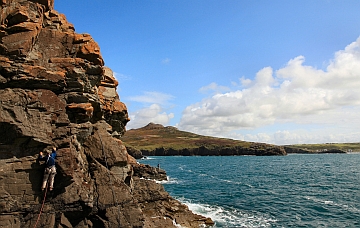
Rock Climbing
The South Face, North Buttress and Craig y Crisial are all in some way affected by the tide, the degree of which can depend of the time of year and weather. All of the crags can be reached by scrambling down rocks on the apex of the promontory, which are free at all state of the tide. Crags and routes are listed from left to right, and are graded and rated with the aid of the old Climbers' Club Guide to Pembroke and old Pembroke Supplement. Since then, the Climbers' Club have published a new comprehensive guide for this area, Pembroke Volume 1: Pembroke North, which adds a significant number of new crags and routes to the area, though the changes to this pages' crags are few. Nevertheless it is recommended that you refer to this book for up-to-date information and route descriptions. Routes are rated using the British Adjectival Grading System. A conversion table of international climbing grades by SP member Corax is available: download it here. With the exception of Tenby South Beach Quarry, bolting is strictly prohibited everywhere in Pembroke, so don’t even think about it here. |
|
Route Symbols:
Craig y CrisialThis south westerly facing crag is on the north side of a small bay immediately north east of the main bulk of St. David's Head. An early route climbed a break up the left centre of the easy slabs Central Groove (VD, 24m), and can be approached by easy angled slabs on the north side of the cliff. Most modern development has taken place on the compact wall of some 25 metres height, which can be reached via abseil at low to half tide. The Thought for the Day is Goose, Pinch and a Punch and Headbager Wall require an abseil onto ledges at the base of a chimney on the right hand side of the crag. |


| No. | Name | Length | Pitches | Adjectival Grade | Technical Grade | Quality | Restrictions |
|---|---|---|---|---|---|---|---|
| 1. | Obscurity | 21m | 1 | E2 | 5c |  | |
| 2. | Flaked Out | 21m | 1 | E2 | 5c | | |
| 3. | Ocean Wave | 24m | 1 | VS | | | |
| 4. | Big Blue | 24m | 1 | VS | 4c | | |
| 5. | The Crystal Maze | 20m | 1 | E1 | 5a | | |
| 6. | Balancing Act | 21m | 1 | HVS | 5a | | |
| 7. | Act of Insanity | 24m | 1 | E3 | 5c |  | |
| 8. | Treasure Trove | 24m | 1 | E4 | 6a | | |
| 9. | The Thought for the Day is Goose | 18m | 1 | VS | 4b | | |
| 10. | Pinch and a Punch | 24m | 1 | E1 | 5b | | |
| 11. | Headbanger Wall | 24m | 1 | E3/4 | 6a | | |


| No. | Name | Length | Pitches | Adjectival Grade | Technical Grade | Quality | Restrictions |
|---|---|---|---|---|---|---|---|
| 12. | Silver Sunset | 18m | 1 | E2 | 5b | | |
| 13. | The Embevmetron | 18m | 1 | HVS | 5a | | |
| 14. | Reachy Roof Route | 18m | 1 | E3 | 6a | | |
| 15. | Gripping Yarns | 21m | 1 | E3 | 6a | | |
| 16. | Weed | 21m | 1 | E1 | 5b | | |
| 17. | Flower Pot Men | 21m | 1 | HVS | 5a | | |
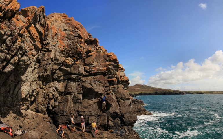
Climbers on the South Face (Photo by Nanuls)
| No. | Name | Length | Pitches | Adjectival Grade | Technical Grade | Quality | Restrictions |
|---|---|---|---|---|---|---|---|
| 18. | Double Take | 14m | 1 | S | 4a | | |
| 19. | Rakish Crack | 15m | 1 | VD | | | |
| 20. | Overhanging Buttress | 15m | 1 | HVS | 5a | | |
| 21. | Central Crack | 15m | 1 | S | 4a | | |
| 22. | Step-Up | 21m | 1 | S | 4a | | |
| 23. | Crack-Up | 15m | 1 | D | | | |
| 24. | The Rake | 18m | 1 | D | | |
|
The wall immediately right of the crag has a ramp/ledge leading up from right to left, which gives another easy route - The Staircase (D, 21m), while the rest of this section of cliff yields a pleasant sea level traverse for several hundred feet at about VS standards. There is a small upper tier about 100 metres east of the main South Face and is just right of the steep part of the descent used to gain the aforementioned crag. The 8 metre buttress is steep in places, and boasts an obvious overhang towards its centre, which can be climber at about 4a/b on its left and around 5c up its centre. |
Weather Conditions and Tides
Weather ForecastThis section displays the weather forecast for St. David's, which is located to the east of St. David’s Head. This gives a pretty good indication of what the weather will be like on the crag, as both St. David's and St. David’s Head sit pretty close to sea level. This weather forecast is generated by the Met Office Weather Widget Tide TimesTide times can have a significant impact on where and when one climbs. It is therefore extremely important to check the timetables before embarking on trip to the area. UK tides information for all standard and secondary ports is provided by the UK Hydrographic Office (UKHO), and displayed on the BBC's website. The link below provides a link to the nearest monitoring station to St. David's Head: |

When to Climb and Essential Gear
The most reliable conditions are in the summer, but the low altitude of the crag may make it a viable option in winter. The gear needed depends entirely on the routes you plan to do. Easier routes will only require a moderate rack, while harder routes will require a something more comprehensive; a good compliment of friends or other camming devices will certainly help. A single 50 metre rope should serve well on most easy routes, however, double ropes would be a wise choice for the harder stuff. In addition to your usual gear, you might want to bring along an abseil rope to speed up access to the base of the crag. |


Getting There
Although there are a variety of ways to get to St. David’s Head, most will probably be coming from the west. If so, when approaching from Carmarthen (SN 405 196) take the A40 Truck Road signposted for Saint Clears (SN 274 160). At the Saint Clears roundabout, continue along the A40 towards Haverfordwest (SM 962 158). Here you will need to leave the A40, take a short detour through the town, and take the smaller A487 which will signpost St. David’s (SM 753 253). Drive into the centre of the city and at the traffic island at the bottom of the hill (marked in the centre by a tall Celtic cross), continue along the A487 signposted for Fishguard and Cardigan. Just as you are about to leave the city limits, there is a left hand junction (SM 757 258) which will signpost Whitesand Bay. Take this junction, and soon afterwards another left hand junction, and follow the road (the B4583) to the Whitesand Bay car park (SM 734 272). Park at the car park, where you will be charged a small fee for the privilege. There is a café and toilet facilities here. Incidentally Whitesand Bay is home to one of the best beaches in Britain, and is well worth a post climb visit. From the car park follow the coastal path north to Porthmelgan (SM 728 279). Here the paths split, and you will need to follow the westward path along the coast. Soon you will reach the first rocks of St. David’s Head (SM 722 279). Craig y Crisial is on the westward facing slab just to the north. For the South Face, scramble over the headland and descend to an obvious zawn. Cross the narrow coll past the zawn and continue to a broad gully running from north to south across the headland. Descent gently southwards along the gully to a rocky platform just above the high tide line. From here, when facing inland, the South Face crag is just to your right. It has a small drainage ditch in its centre and a line of quartz running laterally across its base. |
Camping and Accommodation
There’s an almost unlimited supply of accommodation within the Pembrokeshire Coast National Park so it would be inappropriate to list it all here. The city of St. David’s and its hinterland is particularly well provided for. For budget accommodation it’s worth checking out some of the following sites: Youth Hostel Association in Wales Independent Hostel Guide Campsites in Pembrokeshire For everything else and more see Visit Pembrokeshire’s website. |
Red Tape and Access
 Whitesand Bay (Photo by Nanuls) Whitesand Bay (Photo by Nanuls)No red tape or access issues here! For climbers, hill walkers and mountaineers, the British Mountaineering Council (BMC) runs a Regional Access Database, which holds mountain/crag specific information on matters of conservation and access, including issues such as nesting restrictions, nature designations and preferred parking: If you are in any doubt about any particular access arrangement, or need to report an incident, you should contact your local BMC Access Representative or the BMC Access Officers for Wales: Elfyn Jones. |
Maps
|
| Navigation Maps Ordnance Survey 1:25k Explorer Series OL 35 North Pembrokeshire/Gogledd Sir Benfro Ordnance Survey 1:50k Landranger Series 157 St David’s & Haverfordwest/Tyddewi a Hwlffordd Road Maps |
Guidebooks
|

External Links
 St. David's Head (Photo by Nanuls) St. David's Head (Photo by Nanuls) Whitesand Bay (Photo by Nanuls) Whitesand Bay (Photo by Nanuls)Government Bodies and Other Organisations Pembrokeshire Coast National Park Authority Association of National Park Authorities Royal Commission on Ancient & Historical Monuments in Wales Maritime and Coastguard Agency Outdoor Organisations and Companies British Mountaineering Council Pembrokeshire Outdoor Charter Group Weather and Tides Tourist Information Travel Information Welsh Public Transport Information Accommodation Youth Hostel Association in Wales Maps and Guidebooks
Cordee Travel and Adventure Sports Bookshop Wildlife and Conservation Joint Nature Conservation Committee Royal Society for the Protection of Birds |