
|
|
Mountain/Rock |
|---|---|
|
|
51.61261°N / 4.98947°W |
|
|
Pembrokeshire |
|
|
Trad Climbing, Toprope |
|
|
Spring, Summer, Fall, Winter |
|
|
164 ft / 50 m |
|
|
Overview
The quiet backwaters of Flimston Bay occupy an attractive little corner of the Castlemartin Range and one that is perhaps less visited than it should to be. While the bay itself is undeniably pretty and is home to a handful of minor crags (which are of moderate interest to the climber), the bay’s real gems lie on the cliffs on either side, for here are hidden some of the best routes in all Pembroke, and dare I say it, the country. To its west are the steep crags of Flimston Ridge, which offer the extreme climber much to get their teeth into, while just to its east is Flimston Slab, home to some of the best low grade climbs in Pembroke. Further east again is Bow-Shaped Slab, a mid grade climbers paradise, which hosts some of the best Hard Severe’s anywhere. The route Bow-Shaped Slab (HS 4a) is worth the trip alone. It’s probably fair to say that the crag has one of the most spectacular approaches the area has to offer, taking the climber past the lithological icons of the Green Bridge of Wales, Elegug Stacks and The Cauldron before introducing you to the softer landscape of the bay. If you’re climbing here during the spring, this approach also offers an amazing opportunity to spot the areas bird life, which includes the highly protected chough (Pyrrocorax pyrrocorax). The presence of choughs does mean however, that between the 1st March and 15th August, climbing is banned on certain crags in the area. At the moment restrictions only affect the West Face of Flimstone Ridge and one route on Crocksydam Point. However, Pembroke’s restrictions are complex and vary annually, see the Red Tape and Access Section for more details. |
Rock Climbing
The climbing at Flimston Bay can be split into nine areas: Flimston Ridge, Flimston Stack, Barrel Slab, Bifters Buttress, Flimston Slab, Oribit Wall Area, Trio Wall Area, Bow-Shaped Slab and Crocksydam Point. All crags described are in some way affected by the tide, the degree of which depending of the time of year and weather. Crags and routes are listed from left to right, and are graded and rated with the aid of the old Climbers' Club Guide to Pembroke, the old Pembroke Supplement and the 2009 Rockfax Pembroke guide. Since then, the Climbers' Club have published a new comprehensive guide for this area, Pembroke Volume 3: Range East – Stack Rocks to Hollow Caves Bay, which adds a significant number of new crags and routes to the area, though the changes to this pages' crags are few. Nevertheless it is recommended that you refer to this or the Rockfax book for up-to-date information and route descriptions. In addition to these sources Rockfax’s website also has descriptions for the routes included in its book, which can be viewed on its online route Database. |


Routes are rated using the British Adjectival Grading System. A conversion table of international climbing grades by SP member Corax is available: download it here. With the exception of Tenby South Beach Quarry, bolting is strictly prohibited everywhere in Pembroke, so don’t even think about it here. Route Symbols:
Please note that good anchors (or any anchors at all for that matter) can be hard to find on many of the cliff tops. A quick recce before committing is advised. |

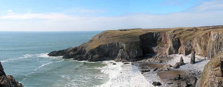
Crags of Flimston Bay (Photo by Nanuls).
| No. | Name | Length | Pitches | Adjectival Grade | Technical Grade | Quality | Restrictions |
|---|---|---|---|---|---|---|---|
| 1. | Stone Bridge | 70m | 3 | E5 | 6b, 5c, 5b/c |  | |
| 2. | Free Masonry | 64m | 3 | E6 | 6a, 6b, 6a |  | |
| 3. | Hanging by the Bridge | 43m | 2 | E5 | 6a, 6a |  | |
| 4. | In Suspension | 40m | 1 | E6 | 6b | | |
| 5. | Sieg Heil! | 34m | 1 | E5 | 6a |  | |
| 6. | The Great Escape | 40m | 1 | E5 | 6a/b | | |
| 7. | Jawohl Mein Fuhrer | 34m | 1 | E5 | 6a/b | | |
| 8. | Gestapo Grooves | 40m | 1 | E5 | 6a | | |
| 9. | Nostradamus | 46m | 1 | E4 | 5c | | |
| No. | Name | Length | Pitches | Adjectival Grade | Technical Grade | Quality | Restrictions |
|---|---|---|---|---|---|---|---|
| 10. | Flakaway | 15m | 1 | HS | 4a/4b | | |
| 11. | Thieves | 49m | 2 | E1 | 5b, 4c | | |
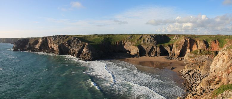
Flimstone Ridge and Flimstone Bay. Flimstone Stack is the most inland of the two small pillars in the centre of the bay (Photo by Nanuls).
| No. | Name | Length | Pitches | Adjectival Grade | Technical Grade | Quality | Restrictions |
|---|---|---|---|---|---|---|---|
| 12. | Kisses for Mayakovsky | 30m | 1 | E2 | 5b | | |
| 13. | Judith's Slab | 49m | 2 | HS | 4b, 4a | | |
| 14. | The Laughing Biscuit | 40m | 1 | E3 | 5c | | |
| 15. | Pinned to the Sun | 24m | 1 | E3 | 5c | | |
Further east is a huge rotten looking slab that is set back from the main cliffs and is cut off by high tide. |
| No. | Name | Length | Pitches | Adjectival Grade | Technical Grade | Quality | Restrictions |
|---|---|---|---|---|---|---|---|
| 16. | Excerpts | 46m | 1 | E1 | 4a/4b | | |
| 17. | Metropolis | 46m | 1 | E1 | 5b | | |
A little further east again is a small overhanging wall. |
| No. | Name | Length | Pitches | Adjectival Grade | Technical Grade | Quality | Restrictions |
|---|---|---|---|---|---|---|---|
| 18. | Teddy Bears Picnic | 21m | 1 | VS | 4c | | |
| 19. | Haven 17 | 23m | 1 | E3 | 5c | | |
| 20. | Thread City | 20m | 1 | HVS | 5b | | |
| 21. | Analgestic | 20m | 1 | VS | 4b | | |
| 22. | Hedgehog | 10m | 1 | HVS | 4c | | |


| No. | Name | Length | Pitches | Adjectival Grade | Technical Grade | Quality | Restrictions |
|---|---|---|---|---|---|---|---|
| 23. | Take it to the Bridge | 27m | 1 | E1 | 5b | | |
| 24. | Laughing and Forgetting | 30m | 1 | E3 | 6a | | |
| 25. | Frome the Sausage Tolls | 40m | 1 | S | 4a | | |
| No. | Name | Length | Pitches | Adjectival Grade | Technical Grade | Quality | Restrictions |
|---|---|---|---|---|---|---|---|
| 26. | Mississippi Mud Pie | ? | 1 | XS | 4a | | |
| 28. | Brassin Pocket | 40m | 1 | HS | 4a | | |
| 29. | Flimston Slab | 40m | 1 | VD | | | |
| 30. | Flimston Crack | 40m | 1 | VD | | | |
| 31. | Meet the Flimstones | 30m | 1 | S | 4a | | |
| 30. | Tideracer | 27m | 1 | VS | 4b | | |
| 31. | Range Rocks Keep Falling on My Head | 12m | 1 | HS | 4b | | |
| No. | Name | Length | Pitches | Adjectival Grade | Technical Grade | Quality | Restrictions |
|---|---|---|---|---|---|---|---|
| 32. | Armadillo Armadillo | 30m | 1 | D | | | |
| 33. | Splashdown | 24m | 1 | VD | | |
| No. | Name | Length | Pitches | Adjectival Grade | Technical Grade | Quality | Restrictions |
|---|---|---|---|---|---|---|---|
| 34. | Left Trio | 34m | 1 | D | | | |
| 35. | Central Trio | 32m | 1 | VD | | | |
| 36. | Right Trio | 34m | 1 | S | | | |
| 37. | Arch Buttress | 75m | 3 | S | | | |
| 38. | Watergate | 21m | 2 | HVS | 5a, 4b | | |
| 39. | Broken Ankle | 24m | 1 | VS | 4c | | |
| 40. | Cold Comfort | 24m | 1 | VS | 4c | | |
| 41. | The Scorpion | 64m | 2 | HVS | 4a, 5a | | |


| No. | Name | Length | Pitches | Adjectival Grade | Technical Grade | Quality | Restrictions |
|---|---|---|---|---|---|---|---|
| 42. | Bomb Corner | 41m | 1 | D | | | |
| 43. | Inset Slab | 40m | 1 | HS | 4b | | |
| 44. | Bow-Shaped Slab | 42m | 1 | HS | 4a | | |
| 45. | Bow-Shaped Corner | 44m | 1 | HS | 4b | | |
| 46. | Atlas | 43m | 1 | E3 | 5c | | |
| 47. | Eye of Battle | 30m | 1 | E4 | 6a | | |
Directly opposite but at right angles to Bow-Shaped Slab is a small compact cliff. |
| No. | Name | Length | Pitches | Adjectival Grade | Technical Grade | Quality | Restrictions |
|---|---|---|---|---|---|---|---|
| 48. | Whiz Bang | 24m | 1 | S | | | |
| 49. | Sweetness and Light | 30m | 1 | HVS | 5a | | |
Forming the west side of Crocksydam Point is an area of huge overhangs and rotten rock. Just right of this is a slanting slabby groove with predominate pink patch up its right hand side. The following routes are on the seaward arête of this slab. |
| No. | Name | Length | Pitches | Adjectival Grade | Technical Grade | Quality | Restrictions |
|---|---|---|---|---|---|---|---|
| 50. | Otherwise Engaged | 24m | 2 | E1 | 5b, 4a | | |
| 51. | Big Pink | 37m | 1 | VS | 4b | | |
| 52. | Alibi | 34m | 1 | HVS | 5b | | |
This photo of Bullslaughter Bay shows the position of Crocksydam Point when approaching from the east (Photo by Nanuls).
| No. | Name | Length | Pitches | Adjectival Grade | Technical Grade | Quality | Restrictions |
|---|---|---|---|---|---|---|---|
| 53. | Fach | 21m | 1 | S | | | |
| 54. | The Feather | 27m | 1 | HS | 4b | | |
| 55. | Stone Flower | 27m | 1 | VS | 4c | | |
| 56. | Crocksydam Groove | 21m | 1 | E1 | 5b | | |
| 57. | Sharp Taste | 27m | 1 | HVS | 5a | | |
| 58. | The Way the Cookie Crumbles | 30m | 1 | E2 | 5c | | |
| 59. | Yellow Brick Road | 30m | 2 | VS | 4a, 4b | | |
| 60. | Straw Man | 21m | 1 | VS | 4c | | |
| 61. | Lost in Space | 24m | 1 | VS | 4c | | |
| 62. | Ring of Bright Water | 76m | S | | |
Weather Conditions and Tides
Weather ForecastThis section displays the weather forecast for Bosherston, which is located just to the east of Flimston Bay. This gives a pretty good indication of what the weather will be like on the crag, as both Bosherston and the Flimston Bay area sit at around sea level. This weather forecast is generated by the Met Office Weather Widget Tide TimesTide times can have a significant impact on where and when one climbs. It is therefore extremely important to check the timetables before embarking on trip to the area. UK tides information for all standard and secondary ports is provided by the UK Hydrographic Office (UKHO), and displayed on the BBC's website. The link below provides a link to the nearest monitoring station to Flimston Bay: |

When to Climb and Essential Gear
The most reliable conditions are in the summer, but the low altitude of the crag may make it a viable option in winter. The gear needed depends entirely on the routes you plan to do. Easier routes will only require a moderate rack, while harder routes will require a something more comprehensive; a good compliment of friends or other camming devices will certainly help. A single 50 metre rope should serve well on most easy routes, however, double ropes would be a wise choice for the harder stuff. In addition to your usual gear, you might want to bring along an abseil rope to speed up access to the base of the crag. |
Getting There
Flimston Bay is located in the Range East portion of the Castlemartin Range.When approaching from Carmarthen (SN 405 196) take the A40 Truck Road signposted for Saint Clears (SN 274 160). At the Saint Clears roundabout, take the A477 Trunk Road towards Pembroke Dock (SM 969 036). Before reaching Pembroke Dock, turn left onto the A4075 (SN 019 027) to Pembroke (SM 989 012). In Pembroke, drive straight over the first small roundabout you reach and drive along the A4139 a few hundred metres and turn left and take the B4319 south towards Castlemartin (SR 915 983). Around 500m after the Merrion Camp (SR 939 968), take a left hand turn at a crossroads (SR 931 970) and drive down an unclassified road to the Stack Rocks Car Park (SR 925 946 ). |


Park at the Stack Rocks Car Park and walk west along the coastal path, past Elegug Stacks and The Cauldron. Flimstone Bay (SR 931 946) is the first large sandy bay after The Cauldron, it can be identified by the presence of two small sea stacks near its centre. The crags of this area stretch from Flimston Ridge (SR 930 944), which is on the western side of the bay to Crocksydam Point (SR 935 942), which is marked on the Ordnance Survey map as Moody Nose. The headland is easily identifiable by a large rock arch which sits on a landward slanting slab. All crags as best accessed via abseil. |
Camping and Accommodation
There’s an almost unlimited supply of accommodation within the Pembrokeshire Coast National Park so it would be inappropriate to list it all here. The city of St. David’s and its hinterland is particularly well provided for. For budget accommodation it’s worth checking out some of the following sites: Youth Hostel Association in Wales Independent Hostel Guide Campsites in Pembrokeshire For everything else and more see Visit Pembrokeshire’s website. |
Red Tape and Access
| Flimston Bay is located in the Range East portion of the Castlemartin Range. This area is an Army firing range, although they do not use exploding ammunition. Access is permitted whenever firing is not taking place, which is normally on weekends, Bank Holidays, and in the evenings (after 4.30). The night firing normally occurs on alternate Mon/Wed and Tues/Thurs nights. The Range is sometimes open during the week, but it is best to check before travelling. Phone the 24 hour help line on (01646) 662367. Because the Flimston Bay area forms part of a Special Protection Area and is an extremely important site for breeding and nesting choughs (Pyrrhocorax pyrrhocorax), parts of it are affected by seasonal bird restrictions. Between 1st March and 15th August climbing is completely banned on the west face of Flimston Ridge and the eastern side Crocksydam Point. It should be noted that Pembroke nesting restrictions are complex and vary annually. Please check the notice boards in Stack Rocks or St. Govan’s car parks for more information. For further information, the British Mountaineering Council (BMC) runs a Regional Access Database, which holds mountain/crag specific information on matters of conservation and access, including issues such as nesting restrictions, nature designations and preferred parking: If you are in any doubt about any particular access arrangement, or need to report an incident, you should contact your local BMC Access Representative or the BMC Access Officers for Wales: Elfyn Jones |  A warning sign (Photo by Nanuls) A warning sign (Photo by Nanuls) |
Maps
|
| Navigation Maps Ordnance Survey 1:25k Explorer Series OL 36 South Pembrokeshire/De Sir Benfro Ordnance Survey 1:50k Landranger Series 158 Tenby & Pembroke / Dinbych-y-pysgod & Penfro Road Maps |
Guidebooks
|


External Links
 Crocksydam Point (Photo by Nanuls) Crocksydam Point (Photo by Nanuls) Flimston Bay (Photo by Nanuls Flimston Bay (Photo by NanulsGovernment Bodies and Other Organisations Pembrokeshire Coast National Park Authority Association of National Park Authorities Royal Commission on Ancient & Historical Monuments in Wales Maritime and Coastguard Agency Outdoor Organisations and Companies British Mountaineering Council Pembrokeshire Outdoor Charter Group Weather and Tides Tourist Information Travel Information Welsh Public Transport Information Accommodation Youth Hostel Association in Wales Maps and Guidebooks
Cordee Travel and Adventure Sports Bookshop Wildlife and Conservation Joint Nature Conservation Committee Royal Society for the Protection of Birds |