Toggle navigation
Mountains
Routes
Images
Trip Reports
Forum
What's New
People
Areas & Ranges
Articles
Trailheads
Canyons
Huts & Campgrounds
Albums
Logistical Centers
Fact Sheets
Lists
Custom Objects
Gear
Plans & Partners
WELCOME TO SUMMITPOST
SIGN IN
REGISTER
Vista Peak
Additional Parents
Image
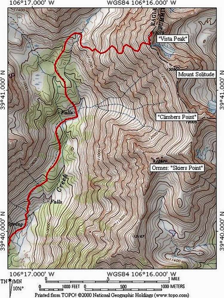
Topographic map of the route...
View High-Resolution Image
Topographic map of the route...
Topographic map of the route on
Vista Peak
. The Pitkin Creek route is 10 miles roundtrip, 4,500 feet elevation gain, and class 2. Software by National Geographic. Jon Bradford
« PREV
NEXT »
JonBradford
on
Jul 24, 2005 10:15 pm
Comments & voting
Other parents
Lat/Lon:
39.69010°N / 106.2652°W
Image ID:
116411
1918 Hits
73.06
% Score
3
Votes
Log in to vote
Comments
No comments posted yet.
to post!
Don't have an account?
Vista Peak
(Mountain/Rock)
« PREV
Viewing
#21 of 27
GALLERY
NEXT »
JonBradford's Image Gallery
« PREV
Viewing
#1138 of 1444
GALLERY
NEXT »
×
You need to login in order to vote!
User Name
Password
Remember me
Forgot your password?
Log me out when I close my browser.
Keep me logged in all the time.
sign in as a user
Don't have an account?
Register now for FREE
Rating available
Suggested routes for you
People who climb the same things as you
Comments Available
Create Albums
Register Here


