Details
Duration: 5:15 a.m. – 4:15 p.m.; 11 hours
Summits: Marshall: 9:00 a.m., Iroquois: 12:00
Route: ADK Loj – Avalanche Pass – Lake Colden – Herbert Brook Path – Marshall – Herd Path to Cold Brook Pass – Bushwhack Iroquois – Descend via East Algonquin Trail – Avalanche Lake – Loj
Total Mileage/Vertical Ascent: 18.6 miles/4900’ vertical
Trail Conditions: Maintained trails were dry to start then very wet from the storms, especially atop the McIntyre ridge; Herbert Brook Herd path was fine to muddy at elevation; Marshall Herd to Cold Brook was extremely muddy
Temperature: 70’s and humid.
Partner: None/Solo
Diet: 2 liters water, 2 protein bars, Chicken Fajita MRE, nuts, 2 blueberry scones
Clothing: Hiking pants with rain pants, Techwick shirt, Rain jacket, Golite trail running sneakers.
ADK Loj to Herbert Brook:
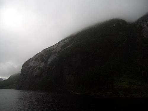
![Avalanche Lake]() Avalanche Lake in the clouds.
Avalanche Lake in the clouds.
July 3, 2008 began with a goal to traverse Mt. Marshall, Iroquois (bushwhack), Algonquin and Wright (with a descent down Wright Slide and subsequent bushwhack to Marcy Brook). The intent of this hike was further scouting for the 46 Traverse: Neither Rico or I had been up the Herbert Brook approach and Iroquois from Cold Brook pass needed further refining though Rico had already descended via the Shepherd Tooth in 2004. I changed my itinerary and decided to tackle Wright another day due to stormy weather.
The traverse began at the Adirondack Loj. I’ve written about the walk to Marcy Dam (2.4 miles) several times, so I won’t beat a dead horse except to say I jogged a couple short flat sections to test my legs and gain a little time on the forthcoming thunderstorms. I wasn’t terribly worried since a local weather station rarely predicted accurate outcomes, but I also didn’t want a “washout” hike in case they were correct. Heavy low clouds loomed above the southern view from the dam. It looked the station’s odds were improving. I’d taken the day off from work, so I planned to make the best of any situation. A quick photo for memory’s sake was my only rest. I continued at a brisk pace to Avalanche Pass/Lake, which I reached at 6:50 a.m., an hour and one half after beginning. I was happy with my pace and felt ready for more.
The trek to Avalanche Camp was relaxing. I stopped for my first bathroom break. A dark eyed junco joined me in the woods. It lectured me on my unacceptable proximity to its nest and all the reasons I should move along. Explicatives in the form of “clicks” emphasized her meaning.
Low clouds made the pass look ominous, yet uniquely beautiful as dramatic gray hues often do. I surveyed the Trap Dike for an upcoming hike on July 5th. It was quite dry, as I’d hoped. My route took me miles past the dike to Herbert Brook, about ½ mile beyond Lake Colden Dam. I stopped at Lake Colden to take pictures of Iroquois and the bushwhack from Cold Brook Pass. I immediately noticed that the auto-focus on my camera did not work. It was locked at infinity, which, if it had to happen, was a good place to be for distance pictures at least. Another quarter mile found me tearing a large hole across the top of my trail shoes. This only added insult to injury especially since I was hiking with trekking poles of different length since one was jammed. Soon after, I again agitated the local wildlife. Three chicks were, apparently, hiding along the moss covered shore and exploded toward open water as I unknowingly neared them. The mother duck picked up the lambasting where the junco left off miles earlier. All I needed now was to stumble on a few bear cubs with the mother! I reached the camping area at the southern end of Lake Colden at about 7:30 a.m. where I saw my first human emerging from a tent after just over seven miles of hiking. I love hiking alone, at times! The peace is unsurpassed.
Marshall:
![Herbert Brook]() Herbert Brook a few hundred yards from the maintained trail.
Herbert Brook a few hundred yards from the maintained trail.
Herbert Brook (at the intersection with Mount Marshall’s herd path) is roughly ten feet wide. I proceeded to drop my lens cap in to the flow…par for course…and ate an energy bar before beginning the gentle route along the crystal brook. Green blankets of sphagnum assaulted the senses as the brook narrowed and meandered. It was picturesque as well as easy on the legs. The grade finally increased as the brook began to display small pools and cascades. It had been a long time since I’d read a description of the trail and nothing in print described the beauty of the terrain. About twenty minutes after beginning the path, the route entered the slide portion. Open views up and back to the east called to my ailing camera. The low volume of water made walking the slide easy even with my old slippery friend…red algae…that covered various areas.
The narrow slide continued for some time until the path exited and began a slightly steeper ascent in the woods on a parallel to the, now narrow, brook. The path was longer than I’d imagined, but I suppose I subconsciously confused it with the herd path from Cold Brook Pass. After an hour, the telltale signs of an upcoming summit began to emerge: stunted growth and a “brighter” sky through the trees along with other more subtle differences in terrain. I finally broke the cloud ceiling and the views became more dull. A light rain prompted me to don my rain jacket and pack cover.
![Herbert Brook Slide]() Herbert Brook slide.
Herbert Brook slide.Another five minutes on the, now light grade trail, found me upon the summit rock at 9:00 a.m. In all the herd path was about one mile 4250 feet with an ascent of 1650 feet. I walked over to view the Santononis, but saw only clouds so I returned to eat a protein bar and slip into rain pants. Mud, clouds, strengthening rain and wind were my only partners.
My next leg was to Cold Brook Pass via the herd path from Marshall’s summit. While the Herbert Brook path was a beautiful meandering walk adjacent to a cascading brook, the subsequent herd path was a shorter, but ledge ridden, muddy, winding mess…exactly how I remembered it. I was a little chilled and couldn’t generate enough consistent speed to really warm up with the ledges, mud and tight fir. The next thirty-five minutes passed with memories of my first hike up and down Marshall in 2004 with my new comrade Rico.
Iroquois’ Bushwhack via the Shepherd’s Tooth:
![Iroquois Cliff Chute Bottom]() Bottom of the chute in Iroquois' cliffs.
Bottom of the chute in Iroquois' cliffs.
Upon seeing the cairn on the Cold Brook Pass trail, I realized the clouds were passing through the pass…they’d lowered as the storm was building. While Marshall was a nice goal and I logged a new trail, I didn’t want to have to return later in order to bushwhack Iroquois. On the other hand, I was searching for the “legendary” chute through the cliffs that blocked the way to my “tree swin” to the summit. As the height of land neared, I found one of several herd VERY faint herd paths. I chose one and, within several hundred feet, began a boulder hop riddled with deep sod holes. I stepped carefully, especially since my glasses were beginning to fog. I was alone about seven miles from the car and a broken leg would not be good. The herd path quickly led into the chute for which I was searching. It was a precipitous climb on all fours in places. The rain was intermittent. Once inside the chute, it was apparent that the cliff had been sheared or collapsed in an area about thirty feet wide. The boulders below were indicative of the collapse. Clouds blew by as I looked upward in excitement.
![Iroquois Cliff Chute]() Top of the chute in Iroquois' cliffs.
Top of the chute in Iroquois' cliffs.
The cliff top exit had two choices, between which, was an untouched area of cliff. A faint path led to the west exit. Both appeared to be a small rock climb. I chose the area of obvious traffic, but couldn’t find a handhold that felt “right” with a pack on. I decided to explore the adjacent exit. The ground led upward under a large piece of ledge, suspended by two walls. Beyond, the channel led a little farther under more suspended rubble. The wall to my east (now, about 4 feet away from the opposite wall) was somewhat stepped, and only slightly slippery. It required a precipitous climb up about twenty feet. I climbed into the crevasse a few steps further for leverage, found a lower step and jammed my back against the east wall. Handholds were abundant, and enough to enable me a secure stopping point on a six-inch ledge. I removed my pack and threw it up into the brush on the sloped “top”. Afterward, I slinked upward after finding several secure trees to aid my quest. I was thrilled, but only one obstacle was surpassed. A hard push of about 800 or so vertical feet through dense fir and stunted birch awaited. I took the time to get some energy gel in my system for the feat.
The bushwhack was everything I expected and dreaded. I had fun. The weather was growing considerably more miserable as I stayed on course for the Shepherd’s Tooth. My glasses had completely fogged so all was obscured. I took care, I couldn’t see well at all and it was a miracle that I’d gotten as far as I did virtually blind. My legs held their strength and the pushups, pull-ups and dips I’d done over the months had obviously paid off, as my upper body strength remained consistent as well. Much of the climb was really a crawl on hands and knees. When upright, the effort included pushing to each side. Small ledges appeared now and again. Herd paths briefly appeared on occasion, but were so undefined that even a chip monk would have problems after a few feet. Only humans would be stupid enough to hope they led somewhere. (Later that evening, Rico verified that a nearby drainage was a bit more loosely woven than the flank I traversed.)
I checked the GPS intermittently to make sure my bearing was sure. I walked a generally straight line toward the rocky tooth. Three hundred feet on a GPS feels like ten miles in the Adirondack off-trail summits. Fifty feet seems similar. The Shepherd’s Tooth finally appeared like a lost ship on a foggy sea when I was within about twenty feet. Wind whipped clouds ripped by against the anorthosite backdrop. The trees briefly opened for the southern boulder field. A small nook faced east and offered a zone of tranquility. I took a small food break to rekindle enthusiasm and strength before heading back south into the woods, around the drop offs just below the cone. Trees grew among the boulders. I still couldn’t see through my glasses and the small drop offs felt like chasms by feel. Faint herd paths to the west gradually led to a “real” rutted path. It lasted only long enough to get me by the tooth before fading back into the head high cripplebrush.
The remaining several hundred feet of the half-mile and nearly 1000 ft. bushwhack was through a thick blanket of intertwined cripplebrush. As the trees dwarfed and my protection diminished in turn, the wind increased along with the pummeling downpour from the west. It seemed endless, but the GPS and decreasing grade disagreed. Distant rocks appeared like mirages a hundred feet east over the sea of prickly green. Since I’d long ago fogged up, I didn’t know whether to believe my eyes so I looked again. It was true! I switched trajectory and crawled over to the exposed peak. The true fun began when I walked out of the protection of the trees. The wind was strong from the west, driving the rain against my back and now exposed pack since the pack cover had a new sixteen-inch tear. I stumbled my way up through the heavy cloud cover and to the anorthosite to the summit cairn. It seemed as if each vertical foot added wind speed and gave me the illusion that I might be blown off the mountain into the gray abyss to the east. It was, of course a perception, but I didn’t want to be blown into a rock or knocked off my feet.
It was noon when I finally threw myself down behind the three-foot cairn opposite the wind. The storm was at its apex and the gusts became stronger and more erratic. The cairn offered some meager protection for several minutes as I regained breath. The precipitation stung as it blew sideways and whipped my wet hair against my face. An odd sound gave me pause. “Rain” or rather sleet was bouncing off my numb hands.
The primary concern of the day was traversing the exposed peaks of Iroquois and Boundary before the thunderstorms hit the area. Thankfully, they did not. I didn’t know that until later, however, so I regained my footing and walked with trekking poles and bent knees as the wind assaulted me and blew the backpack sideways on my back. The protected northern side of the rocky crown decreased the wind speed so I could eat and regain my composure.
As disturbing as it may sound to some, I had fun on Iroquois’ south side in the rain and whipping wind. A valid description of the Iroquois whack might be (please excuse the run-on sentence): A great bushwhack to REALLY to experience the cozy feeling of Adirondack cripplebrush while doing squats combined with alternating dips and inclined pull-ups in obscured visibility (from trees and rain/fog) while navigating to an invisible target after a short rock climb. Its total toll was a sixteen-inch hole in the pack cover, multiple tears across my shoes, a hole in my rain pants and several lacerations. In short, it was a normal hike.
Boundary and the Finish:
After feeling Iroquois’ summit, I made the decision not to hike Algonquin or Wright. I had to walk over Boundary, just north. It’s not quite as high as Iroquois, but the wind was still an issue. The beaten herd path of the col between was a recipe for mud soup, but offered diversion. It mattered not, since the walk over washed it off. A walk of twenty-five minutes (from Iroquois) led me to my bailout trail down the steep east side of Algonquin. In retrospect, every side is steep. A few minutes descent lessened the rain as well as the driving wind. Clinging wisps of cloud stuck to the trees at various intervals.
As my fingers regained feeling, thoughts entered my mind: comparative thoughts and the diversity of the Adirondacks. The main focus was that of weather contrasts and in relation to hikers. The calm of the east side trail was deceptive to the reality just moments away and a few hundred feet in elevation. I couldn’t have imagined (if I was climbing upward) that the summit might be so windy that standing firmly was impossible or that the light rain would be indicative of horizontal sleet in July. After so many run-ins with weather like this in all seasons, I know the possibility always exists for stark contrasts and am always prepared with gear, but a new hiker to the ‘Daks might not be. Written signs in various areas along the trail serve as warnings, but how well are the heeded?
![Avalanche Lake, Mt. Colden and the Trap Dike]() Colden's western cliffs and Avalanche Lake.
Colden's western cliffs and Avalanche Lake.
The anorthosite base of the path, eroded from foot traffic was a current of runoff and not as slippery as one might expect. Eventually, the “paved” path gave way to rock hops and intermittent dirt. It intermingled with the stream as the elevation lessened over the two miles and over 2000 foot of descent to the intersection with the Avalanche Pass trail at the northern end of Lake Colden.
Avalanche Pass took on a new look as ominous as the view south earlier in the day. This time the clouds were much lower, obscuring the summit of Mt. Colden and dipping into the Trap Dike, which carried a much heavier flow of water. The gentle trickle had turned into a loud roar. Rain blew up the lake and soaked my attempts to take pictures. The protective lens of the camera fogged so I removed it to capture the moment. I was successful if not wet and chilled. The traverse north along the boulders of the lake passed quickly as did the remaining five miles. I arrived at the car at 4:15 p.m. content to have conquered two of my goals.
Subsequent Hike (2 days Later): Colden’s Trap Dike & Pics of Marshall-Iroquois Scout:
![MudRat on Colden s Great Slide]() On the Great Slide with Marshall and Iroquois in the background (photo by Mike T.
On the Great Slide with Marshall and Iroquois in the background (photo by Mike T.
Two days later (July 5, 2008) a FL friend (Mike T.) and I hiked Colden via the Trap Dike. This hike had several missions: 1. Take a friend hiking; 2: Obtain pics of Iroquois and Marshall as well as Wright/Algonquin slides for later climbs and 3: A chance to do my annual Trap Dike Hike. I had the pleasure to meet Neil L. for the first time at the trail head and then again on the summit. I knew him through the hiking forums and Rico, but not in person.
Conditions in the Trap Dike had subsided to a calm level. It was only slightly wet in the final climb up the Crux. The route up the dike and subsequent Great Slide gave me countless opportunities for my pictures including many of Mike. The bleak conditions of July 3rd had transformed into a bluebird blue day in the 80’s with late afternoon clouds. Previously bug-free conditions gave way to hordes of deer flies and swarming black flies bent on blood-letting. Mike did well on his first climb in the Adirondacks. Hiking in the woods was not foreign to him, but the terrain that I drug him up was! We descended via Lake Arnold and completed the hike in 9 hours and 45 minutes starting at 9:15 a.m.
Comments
No comments posted yet.