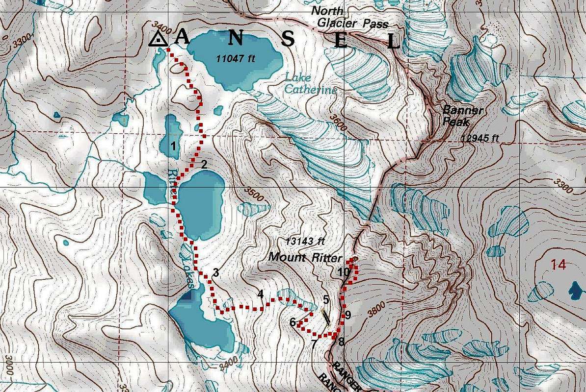
Caption: (1) avoid this most northern of the Ritter Lakes: there is no easy way around it, although it may look tempting, particularly on your way back; (2) on this steep slope north of the lower lake keep west, at the very edge of a rocky ridge; the route in the middle is a real slog; (3) follow the creek coming from the upper lake almost to the outlet; leave the creek in the last fifty feet, and exit to the lake's terrace via an opening just east of the creek bed; (4) scramble up the fan above the lake until you reach the lower bowl; once in the bowl, look for a V-notch on the ridge line south of you (to your right, on your way up); (5) if you continue too high in the lower bowl, you will reach the dreaded "chockstone chute"; it leads to the right place, but the level of difficulty is much higher than class-2; (6) in the upper half of the lower bowl, look for ledges that would allow you an easy traverse in the south-west direction to the V-notch; the "notch" is actually a bottom of the upper bowl; (7) the upper bowl is another real slog; when going up, it is probably easier to stay near the left (north-east) rocky edge and avoid the use trail in the middle of the bowl; when going down, it is fine to descend by the use trail; the bowl is split by a ridge in the upper half; when going up, take the left (easterly) segment, which looks like a dead-end chute; the wider right segment continues to one of peaks on the south ridge of Mount Ritter, and it is of no interest in this hike; (8) when near the top of the left chute, find an easy traverse to the main south ridge of Mount Ritter; (9) take about 180 steps downhill along the ridge (count the steps!) to the saddle, then continue up the south-east slope (but always close to the ridge line) towards the summit which is in plain view in front of you; (10) in the last two hundred feet, exit to a ridge just west of the top (on your way up, that would be left of the top), then walk to the summit. Find
more details about this route.


