

-
 59562 Hits
-
 83.01% Score
-
 17 Votes
|
|
Area/Range |
|---|---|
|
|
41.69701°N / 77.45773°W |
|
|
Hiking, Mountaineering, Toprope, Bouldering, Ice Climbing, Mixed, Scrambling, Skiing |
|
|
Spring, Summer, Fall, Winter |
|
|
Overview
The Allegheny Plateau stretches from central New York state southwest through Pennsylvania, West Virgina, Ohio, and into Kentucky, hugging the western edge of the Appalachian Mountains. However, the Northern Allegheny Plateau is typically the area in north-central and northwestern Pennsylvania, and at this point, will be the area that this page focuses on. This area holds 8 Pennsylvania State Forests, including Clear Creek, Elk, Loyalsock, Moshannon, Sproul, Susquehannock, Tiadaghton, and Tioga state forests and one National Forest, the Allegheny National Forest. This area is also now considered the 'Pennsylvania Wilds,' a new initiative by the state. Pennsylvania Wilds
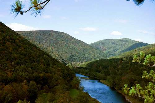
A fine vista from the Bob Webber Trail in the heart of the Allegheny Plateau in PA. Late September and early October is one of the best times of the year to explore this area, due to the incredible foliage and the still pleasant weather.
Although most of the hiking in this area isn't summit-related, there are several mountains, or in reality, hills, that provide a summit experience in this area. A few of these "mountains" are Gillespie Point, Hemlock Mountain, Half Dome, and Mount Tom. In our opinion, some of the best views in the state of Pennsylvania can be had from the top of Hemlock Mountain. Half Dome has a fun "climbers trail" for its route, due to a little scrambling over rock outcrops on the way up. Gillespie and Mount Tom are intensely steep (~ 1000 ft. elevation gain in roughly 1 mile), but fun hikes. All of these mountains have wonderful views from the top. The elevation of these mountains don't go anywhere near tree line, but the volunteers for the DCNR have created and maintain some great cleared "vistas" at the top of these hills so that there can be views of the surrounding area. Also, in our experience hiking up and around these mountains, we've only ran across a few people. If you like solitude, it can be found easily on these mountains and on most of the trails in this area. Eventually, we should have a page up for each of these mountains.
State Parks
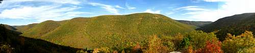
One of the gems of the Allegheny Plateau in PA is the Pennsylvania Grand Canyon, which is also known as the Pine Creek Gorge. Check out mtwashingtonmonroe's page on "The Grand Canyon of Pennsylvania." His page is excellent, and gives some great information about "the Canyon," as we like to call it. There are 2 state parks located in the canyon area - one on each side of the canyon - Leonard Harrison State Park and Colton Point State Park. These are two of the finest parks in the state, however, in the area known as the "Pennsylvania Wilds," which comprises a large chunk of the Allegheny Plateau in Pennsylvania, there are 25 other state parks. This is amazing due to the relatively small size of this area, but this just gives an idea of how wild and relatively undeveloped this area of the state is. Credit should be given too to the state of Pennsylvania - it has done a great job of buying, protecting, and preserving land in this area through designation of state parks, wild areas, and state forest lands.
Another unique state park is Cherry Springs State Park. It is also located in this area of PA, and has some of the very best stargazing in the Eastern United States, due to an almost complete lack of light pollution. The view of the stars at night is one of the best features of this area. When the weather is clear, the view of the stars is magnificent - paralleling some of the nighttime skies in the Western US.
Activities
The Allegheny Plateau in PA offers a variety of activities, depending on the season of the year. There are a number of great hiking trails that can be used throughout the year - for a quick day hike, a weekend backpacking trip, or an even longer backpacking adventure. Many of the trails in this area interconnect, creating the possibility of backpacking trips longer then a few days. See below for a list of some of the better hiking trails in the area.
Many of the same trails that are great for hiking all year long are also excellent for cross-country skiing during the winter months. There are even trails in this area that are specifically used for cross-country skiing. The conditions need to be right - so check the weather if interested - but this area of Pennsylvania receives 40+ inches of snow on average, and most years, snow will cover the ground from at least December through February, and it isn't uncommon to have heavy snows in November, March, and April. The Western part of this region also receives some lake-effect snow from the Great Lakes, and causes the snow-totals to be even larger in some years.

Allegheny Reservoir in the Allegheny National Forest
One of the most beautiful compliments to the great hiking in this area are the wonderful mountain streams. All of the hiking trails posted on this page trek across or along some of these streams, and it is common to come across waterfalls on these trails. There are several rivers, creeks, and lakes where canoeing, kayaking, or rafting is possible in this area. Also, some of the best fishing in the east is prevalent in the Allegheny Plateau region. Native trout are common in most of the small, wild streams in the hills, and there are stocked trout in many of the larger streams. There is excellent fly-fishing in several creeks, especially in Pine Creek and a few of its tributaries. Ice fishing is also a popular activity on some of the larger lakes and reservoirs throughout the region. If you like to fish, and are in this area, it can be a great way to experience the natural beauty that the Allegheny Plateau region has to offer.
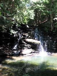
One of the many charming streams in the Allegheny Plateau in PA.
Pine Creek Rail-Trail
One of the best ways to explore the PA Grand Canyon is on the newly completed Pine Creek Rail-Trail. It follows an old railroad grade, most of the time along Pine Creek at the bottom of the canyon. It runs near and along Pine Creek for over 60 miles, from Ansonia, PA in the north to Jersey Shore, PA in the south. There are many access areas in between, for biking, fishing, and boating. There are also several camping areas on the way, as well as several towns with amenities. The towns of Blackwell, Slate Run, Cedar Run, Waterville, and Jersey Shore all have places to eat, and there are several hotels in a few of these towns too. In our opinion, this trail can be a fun and interesting way to explore the heart of the Allegheny Plateau in PA. It would be best to do it in the fall or spring (the most beautiful times of the year in this area), and if possible, over several weekdays. The weekends tend to be crowded with tourists, but the rest of the week is great for solitude.
In addition to these activities, there are quite a few good mountain biking routes, and we know people that do some climbing in the area. However, we don't have information about climbing routes or quality at this time.
Getting There
The main bulk of wild area in the Allegheny Plateau in PA is accessible via several roads: it is boxed in by I-80 and I-79 on the south and west sides, US Route 6 on the north side, and PA Route 287 on the east side. While this doesn't contain all of the wild area and hiking exactly, one of these roads will get you close to much of the best hiking and backpacking the state of Pennsylvania has to offer. These roads will also give access to Pennsylvania's only national forest, the Allegheny National Forest, as well as some of the largest and most wild state forests in Pennsylvania.
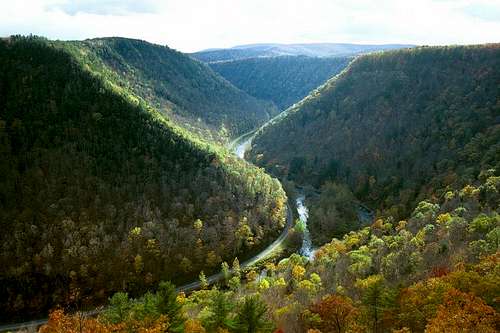
The view of the PA Grand Canyon from Barbour Rock is one of the best views of the canyon. This is one of the many beautiful areas located in the "Pennsylvania Wilds."
Red Tape
There is very little Red Tape for enjoying the outdoors in the Pennsylvania Allegheny Plateau. There are no permits required for hiking in PA.
Fees
There are minimal fees for camping in all PA state parks, usually ranging from $10-12 per night. Primitive camping is permitted on almost all state forest land in Pennsylvania for no fee, unless otherwise marked.
Permits for camping on state forest lands are not required, unless: you stay at a campsite for more than one night, a campfire is desired during fall or spring "fire" seasons, you are camping with a group of 10 or more people, you desire an emergency contact, or you need to camp with or from a vehicle. Also, a permit is required to camp in the Pine Creek Gorge in Tiadaghton, or in the Tioga State Forest, since these can be heavily used areas. There is no fee required to camp here. To acquire a permit, contact the PA state forest district office
There are very few parking fees, although you may encounter fees at some of the state parks. There are no fees to park at state forest lands, or at the Allegheny National Forest.
Although there are no fees to camp in the state forest lands of Pennsylvania, please follow the "Primitive Camping Guidelines and Ethics."
Hunting
DO take note of hunting seasons, since hunting is permitted in the Allegheny National Forest as well as all of the state forests in the area. Hunters do frequent some of this area, and from October - January, it's a very good idea to wear orange while on the trail. Hunters are only permitted to hunt Monday- Saturday, so if you're hiking on a Sunday, it won't be a worry. Be especially careful during deer season from the Monday after Thanksgiving until mid-December. Deer hunting is huge in this area, and you will definitely want to wear orange while hiking during this season.
Wildlife

Allegheny Plateau Salamander
This area of Pennsylvania is abundant in wildlife. It boasts healthy populations of wildlife that are not common in this part of the country. One of the main attractions is the largest wild herd of elk east of the Rocky Mountains. There are also healthy populations of black bears, whitetail deer, bobcats, coyotes, bald eagles, osprey, wild turkeys, river otter, and much more. There are supposed sitings of mountain lions, although the Pennsylvania Game Commission denies their existence in the state.
The Allegheny Plateau of Pennsylvania is also home to many species of snakes, some of which are venomous - including the Timber Rattlesnake and Copperheads. Be especially watchful for Timber Rattlesnakes while hiking in this area. They are quite common, and as long as you don't surprise them or threaten them, also quite harmless.
Pennsylvania Wild Elk Heard
The Northern Allegheny Plateau is home to the largest wild herd of elk east of the Rocky Mountains. Elk were originally native to the area, but were wiped out due to over-hunting. In 1913, the Pennsylvania Game Commission began to reintroduce elk to parts of PA with Rocky Mountain Elk from Yellowstone. The management of the herd continues to this day, and the population continues to thrive and grow, reaching around 800 elk. The range of the elk herd in Pennsylvania span 5 counties in the Allegheny Plateau, including Elk, Cameron, Potter, Clearfield, and Clinton Counties. The best places to encounter PA elk are in Elk and Cameron Counties, especially near the towns of Benezette (PA State Route 555) and Sinnemahoning. We have even encountered them (3 large bull elk) while backpacking the Bucktail Path in this area.
Black Bears and Porcupines
If backpacking or camping overnight in this area, the two animals you should be most concerned about are black bears and porcupines. Black bears in this part of the state are abundant, but rarely disturb humans. However, if you are irresponsible with your food at night, you could have an unwanted nighttime visitation. Take precautions by storing food in your car, or by hanging it in a bag in a tree away from your campsite. If you have a bear bin for backpacking, that would work too.
Porcupines are also abundant, and can be a nuisance to backpackers. It is recommended that you sprinkle mothballs around your car when you leave it for a couple of days. Porcupines are known to chew radiator hoses in your car (for the salt?), but will stay away if there are mothballs present...at least that's what I've heard. A good story of the nuisance and surprise of porcupines can be found here
Hiking Trails
The Allegheny Plateau has an incredible amount of hiking opportunities for the strolling day-hiker or the long-distance backpacker. There are almost an uncountable amount of trails but we will try to review a few of the more popular and maintained trails throughout this region. Listed below are some of these trails with short descriptions of each and links to find out more about these Pennsylvania gems.
ALLEGHENY FRONT TRAIL
The Allegheny Front Trail is a 40 mile circuit trail that does a loop around the Black Moshannon State Park. The trail itself is located in the Moshannon State Forest. It is located just a short drive north of State College, PA and offers many fine vistas, scenic streams, and wilderness areas. A portion of the trail follows the Allegheny Front (from which it gets its name) which is the dividing ridge between the ridge and valley section of the Appalachian Mountains and the Allegheny Plateau. On this ridge some fine views can be seen. The rest of the trail follows the contours of the Allegheny Plateau. For more information, click the trail name above.
BLACK FOREST TRAIL
A 42 mile loop trail that may be the best in Pennsylvania. This trail covers some of the most remote areas in the state and is a very rugged trail with plenty of up and downhill hiking. It boasts as many scenic vistas as there are miles on the trail, has numerous wild streams and stream crossings, and even has a virgin hemlock to boot. The trail starts near Slate Run, PA and works its way up Slate Run. Eventually it makes its way to County Line Branch of Young Woman's Creek, where it has 20 stream crossings (a few of which are wet), and then works its way through a number of small streams while overlooking the Pine Creek Gorge. A map and guide set can be purchased from Pine Creek Outfitters, listed under the 'External Links' below.
 A view from the Black Forest Trail
BUCKTAIL PATH
The Bucktail Path is a 34 mile linear trail that is one of the most seldom used in the state forest trail system. It crosses some remote country through the Elk State Forest in eastern Cameron County, Pennsylvania. There are some incredible views, picturesque streams, and steep descents and accents. One of the most dramatic views on the trail is when you reach a forest fire scarred hilltop, which only has shrubs about waist high, and you can see 360 degrees of rugged, remote Pennsylvania. The trail also passes through some state forest managed 'Wild Areas' and 'Natural Areas' in which logging and human activity is kept to a minimum. Be prepared for being alone on this hike. A map and guide set for this trail can be purchased online at The Hiking Spot, listed under 'External Links' below.
CHUCK KEIPER TRAIL
The Chuck Keiper Trail is a loop trail of 59 miles, making a circle through the Sproul State Forest in Clinton County. There are two different intersecting trails which one can make a few smaller loops from, instead of doing the entire trail at once. The trail is known for the many wild areas and natural areas that the state has designated as such. It was named for Chuck Keiper, who was a District Wildlife Conservationist in Clinton County from 1951 until his death in 1973. There have been recent relocations on the trail due to tornadoes and wildfires that have caused disruption. To learn more about the trail or to request a free map, click on the trail name above.
DONUT HOLE TRAIL
The Donut Hole Trail is a 90 mile linear trail that forms an upside-down U in northern Pennsylvania, cutting through the Sproul State Forest. It begins just to the north of Farrandsville and ends to the west in Jericho. The trail links up with the Susquehannock Trail for approximately 9 miles in northern Clinton County. The Donut Hole Trail gets its name from its shape (apparently it resembles a Donut Hole). It features scenic views, mountain streams, various forest types, wetlands, secluded backwoods areas, and a fire tower. A trail map can be found by clicking the name of the trail above.
GOLDEN EAGLE TRAIL
At 9.1 miles, many consider this the best day hike in Pennsylvania, since camping on the trail is not allowed. It has about everything that northern Pennsylvania can offer. It follows a few beautiful streams, has some steep climbing, has a few picturesque overlooks, and winds its way up the Raven's Horn, a ridge of exposed rock. The trailhead is located just a few miles south of Slate Run, PA. It is a loop trail on the eastern side of the Pine Creek Gorge and it climbs from Pine Creek up to the ridge-line far above the stream. A guide for this hike can be found in the Black Forest Trail guide or in Tom Thwaites' 50 Hikes in Central Pennsylvania both of which can be purchased at The Hiking Spot, listed under 'External Links' below.
LOYALSOCK TRAIL

A view from the Loyalsock Trail
The Loyalsock Trail is a 60 mile linear trail through Lycoming and Sullivan counties of Pennsylvania. It starts 10 miles north of Montoursville and heads northeast, finishing just 3 miles north of Laporte. It offers many spectacular vistas, knobs (or mountains), waterfalls, scenic streams, while crossing rugged and isolated terrain. The trail was originally laid out in 1951, using old railroad grades and logging roads. The Loyalsock Trail has since seen many relocations and even some extensions to its’ present day length. For more information on this trail, check out the Alpine Club of Williamsport, where a trail guide can be purchased.

Mountain laurel, Pennsylvania's state flower, can be found along trails in late May into June.
MID-STATE TRAIL
The Mid State Trail is still a work in progress. It currently strechtes from the PA-Maryland border to northern Pennsylvania. It will eventually span more than 300 miles as it goes from border to border through the state of Pennsylvania. It technically does not meet the Northern Allegheny Plateau until it crosses Rt 220 near Lock Haven in the northern section of the state. From there the trail traverses many ridge-lines and streams until it reaches the unfinished sections of Tioga County. Over the past few years the trail has been moving northward, but now a large section of private land intersects two pieces of trail. It will be an on-going process to expand the trail the entire height of the state. For more information on this trail or to purchase a map and guide set go to the Mid State Trail website, listed under 'External Links' below.
NORTH COUNTRY NATIONAL SCENIC TRAIL
The North Country National Scenic Trail cuts across northwestern Pennsylvania just like the Appalachian Trail cuts across the state in the southeast quadrant. It totals 180 miles throughout the state and cuts through the heart of the Allegheny National Forest in the northwestern corner of the state. For more information, or to purchase guides and maps, visit the trail website at North Country Trail Association.
OLD LOGGERS PATH
The Old Loggers Path is a 27 mile loop trail in northern Lycoming County of Pennsylvania. It follows many of the old railroad grades from the logging era and this is where it gets its name. The trail is a pleasant hike crossing streams with waterfalls and showcasing a few good vistas. The best vista, Sharp Top vista, is at mile 19. The Sharp Top vista has a gorgeous view of the surrounding plateau and ridge and valley areas of Pennsylvania. A guide to the Old Loggers Path can be found in either of the books 50 Hikes in Central Pennsylvania or Backpacking Pennsylvania listed below.
QUEHANNA TRAIL
The Quehanna Trail is one of the most remote and rugged trails in the state of Pennsylvania. It forms a 75 mile loop through the Moshannon and Elk State Forests and crossing through the Quehanna Wild Area. The trail offers vistas, mountain streams, remote back-country areas, various forest types, open meadows, and the beauty of north-central Pennsylvania. A guide to the Quehanna Trail can be found in either of the books 50 Hikes in Central Pennsylvania or Backpacking Pennsylvania listed below.
SUSQUEHANNOCK TRAIL
The Susquehannock Trail is an 85 mile loop trail through Potter and Clinton Counties. It begins (and ends) on top of Denton Hill, behind the DCNR ranger station, in central Potter County. This trail is known for views, wild streams, forest types, wetlands, and back-country areas. It traverses near or through 4 state parks, including Denton Hill State Park, Cherry Springs State Park, Ole Bull State Park, and Patterson State Park. It also goes through the town of Cross Fork, PA, so there is an opportunity to resupply if spending numerous days on the trail. In my opinion, the best area to visit on the trail is in the Hammersly Wild Area, in which the trail passes through an area devoid of roads and parallels the beautiful Hammersly Fork for approximately 7 miles. A map and guide set can be purchased from Pine Creek Outfitters, listed under the 'External Links' below.
WEST RIM TRAIL
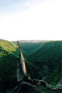
A view from the West Rim Trail
This 30 mile linear trail begins on the northern end in Ansonia and the southern terminus is below Blackwell, hugging the western rim of the Pine Creek Gorge (or Pennsylvania Grand Canyon). It has some of the most breathtaking views Pennsylvania has to offer, including Barbour Rock, an exposed rock wall along the rim. The trail ambles near the edge of the gorge or plunders down into beautiful hollows along the gorge, making two substantial deviances from the rim, one around a state park and the other around private land. This would be a great start for those who have never experienced the Pennsylvania Wilds. A map and guide set can be purchased from Pine Creek Outfitters, listed under the 'External Links' below.
Other Hiking Resources
These trails listed above are some of the most used and well-known trails throughout the Northern Allegheny Plateau. However, there are so many day-hiking and other backpacking adventures one could have in this area, that it would be impossible to list all of them. Below is a list of various guides to other trails that could lead to a vast array of hiking opportunities. These guides can be purchased at Pine Creek Outfitters or The Hiking Spot, listed under 'External Links' below.
50 Hikes in Central Pennsylvania
by Tom Thwaites
50 Hikes in Western Pennsylvania
by Tom Thwaites
Short Hikes in Pennsylvania's Grand Canyon
by Chuck Dillon
Short Hikes in God's Country
by Chuck Dillon
Backpacking Pennsylvania
by Jeff Mitchell
Hiking Pennsylvania
by Rhonda and George Ostertag
External Links
PA Hikes.com
Wild Asaph Outfitters
Rock Climbing
Pine Creek Outfitters
Allegheny National Forest
Department of Conservation and Natural Resources
Keystone Trails Association
Mid State Trail
The Hiking Spot