Overview
Lemmon Valley is located about 10 miles north of Reno, Nevada. It is the valley north of
Peavine Peak 8266’ and is thus obscured from view when looking north from the Biggest Little City in the U.S.
At the north end of Lemmon Valley sit two ridges separated only by a two-lane road. Each north-south ridge tops 6,000’ and terminates at the south end of Antelope Valley to the north.
Peak 6030 is on the west, the highest point on a four-mile long ridge sometimes referred to as Juniper Ridge. Peak 6021 is on the east, the highest point on a three-mile long ridge sometimes referred to as Coyote Ridge.
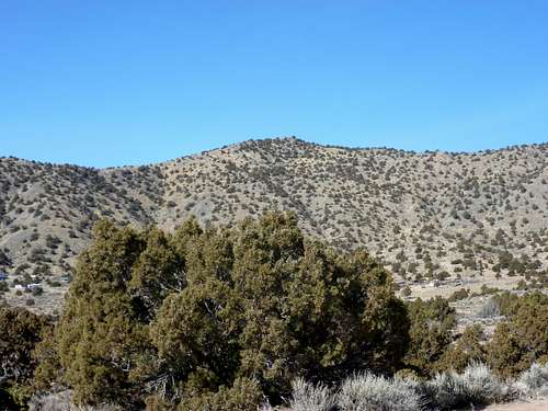
![Peak 6041 from the upper slopes of Peak 6021]() Peak 6030 East face
Peak 6030 East face![Looking up at Peak 6021 from the west]() Peak 6021 West face
Peak 6021 West face
There are multiple lower summits on these ridges, and they can be explored, jogged, or perhaps even mountain biked.
These summits are best approached from Matterhorn Blvd (the paved road between them). This area is on private and public lands, but access is mostly straightforward. Matterhorn Blvd provides the easiest access, because it is closest to Reno, Nevada, and not far off of Highway 395.
There are plenty of great views with the Sierra Nevada to the southwest and numerous desert peaks in all other directions.
The best time to hike here is probably in early winter, when it is still dry and often snow free. Spring is possible, but beware of muddy conditions. Late fall is possible, but only if it isn’t too warm. 50-60 degrees is ideal conditions here.
Peak 6030 coordinates are given for this page.
Peak 6021 coordinates are: 39.722528, -119.818238
Getting There
From Reno, drive north on Highway 395 to Exit 74. Drive north on Lemmon Valley Road for about 4 miles and continue as the road turns northwest towards to a residential area. Once near the residential area, take a right on Waterash, then a right on Tupelo, and a left on Matterhorn Blvd (aka CO HWY 165). Follow it out of town, and then continue for a little under a mile. The best place to park is at the Silver Arrow Ranch Regional Archery Facility. It is Washoe County Open Space land, although maps I have found show it to be on federal land. Whatever the case, it is safe to park here.
To hike Peak 6030, it is better to park on dirt just off Matterhorn Blvd. near the sign for the Archery Facility. For Peak 6021, it is better to drive up 1/3rd of a mile and park 100’ up at the parking area for the archery course.
An alternative, slightly longer route, is described below, accessed from closer to the residential area.
Route Information
Peak 6030
For Peak 6030, there are a couple of hiking options. The most straight-forward way is across the street from the entrance to the Arrow Ranch Regional Archery Facility. However, a sign on the road says it is private and no trespassing. What is not clear is whether this is simply intended to keep people away from a house on the right (north) side of the road or off the road itself. My understanding from maps is that the road shortly enters federal lands. The road then heads steeply up the slope, gaining nearly 400’ in a quarter mile. Once the road levels out a bit, it heads northbound and approaches the base of the summit. The summit can be reached via a 160' bushwhack.
If nervous about this route, and wanting to be certain that you are on federal lands in the approach, walk down Matterhorn Blvd southbound for about a quarter mile and find a road/trail heading west. Head towards a canyon, loosely following whatever trails are in the desert below.
![Heading towards the canyon up to Peak 6041]() Heading towards the canyon
Heading towards the canyon
In about a third of a mile from the road, you will enter the canyon which meanders up via a use trail that peters out towards the top, but ends at a road after about 15 minutes or so of walking. Take a right on the road as it winds around and towards the summit of Peak 6030.
This route is perhaps more enjoyable, but takes a little longer and involves about 1 ¾ miles of hiking and 850’ of elevation gain one way. This is a good descent route if taking the direct route described above.
Peak 6021
From the archery range parking area, head over a staircase over the fence and walk carefully through the course, heading mostly on main roads heading up the slope and northbound towards Peak 6021. Find your way to the main road heading up the slope. Ultimately you will have to cross over a fence on a main road heading as you head towards Peak 6021. The land past this fence is supposedly on federal lands, and indeed there are no signs indicating it is private lands. Use trails head up towards the rocky summit. The total distance is about 1 1/3rd miles with 790’ of elevation gain.
![Zoom shot of the rocky summit of Peak 6021]() Looking up at the rocky summit of Peak 6021
Looking up at the rocky summit of Peak 6021
An alternative route that is to take Hungry Mountain road just north of the residential area, before you get to the Archery Range turn off. Drive a half a mile or so up the road and there should be a place to park before it curves to the right at 39.7005, -119.8282 and 5178’.
Walk up another tenth of a mile and take your first left. There are homes nearby and you don’t want to get on private land. Head up the road for a mile until you reach the top of the ridge. Continue for another mile to the summit, mostly on dirt roads.
In total, the round trip distance is about 4 ¼ miles, with a one way elevation gain of about 975’. This parking area can be used for the canyon route to Peak 6030 as well, adding only one third of a mile in round-trip hiking distance.
Red Tape
There is a mix of private and federal land. Parking at the Silver Arrow Ranch Regional Archery Facility is a good start. For Peak 6030 there are some pegs in the ground that say No Trespassing on the road just below the peak. The summit itself is on private land. However, the rule of thumb I use is to not cross the pegs (which are on the west side of the road). There are no other signs. As for Peak 6021, there are no real issues. It is on federal lands. There is private land on the west face of the peak, and just north of it. However, you won’t encounter any signs indicating that you are not supposed to be there. There are fences on the road en route from the Archery Facility, but none of them have signs blocking access

 Peak 6030 East face
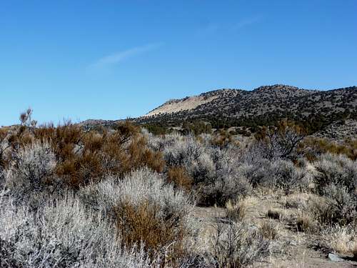 Peak 6021 West face
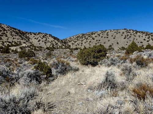 Heading towards the canyon
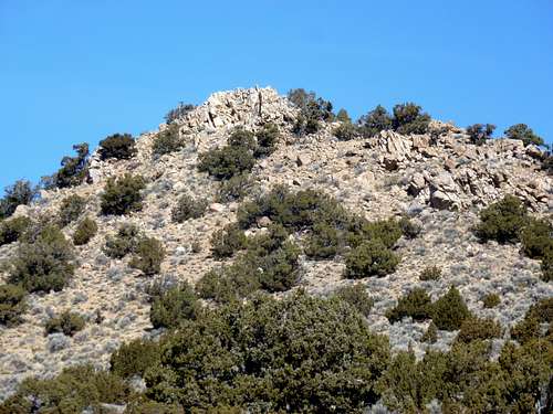 Looking up at the rocky summit of Peak 6021