New 3D Wall Maps of Pacific Northwest
Product Description
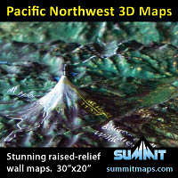
Summit Maps has just introduced two new stunning 3D raised-relief maps of the Pacific Northwest. One is centered on Seattle and covers the Olympic peninsula, the Northern Cascades, and down to Mount Rainier. The second is centered on Portland and covers the Pacific Coast and the Northern Oregon and Southern Washington mountains, including Mt Adams, Helens, Hood, and Jefferson. These precisely molded maps offer a beautiful and funcional display on a wall of home, office, or classroom. See these two new maps, and all of Summit's 3D maps, at www.summitmaps.com.Features
3D molded shape clearly shows the terrain detail.High-resolution satellite images provide a true-earth reference tool.
Mountain peaks, trails, mountain ranges, roads and towns are marked/labeled.
Can be framed with black metal, black oak or natural oak finish moldings.
A unique and attractive display for the home or office wall of any mountain enthusiast.
Images
 |