
-
 7423 Hits
-
 77.48% Score
-
 8 Votes
|
|
Mountain/Rock |
|---|---|
|
|
47.86488°N / 122.23645°W |
|
|
Snohomish |
|
|
Bouldering |
|
|
500 ft / 152 m |
|
|
Overview
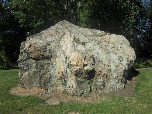
**Disclaimer! I am not in any way part of the wider Seattle bouldering community and the routes I describe are purely those I climbed during the spring and summer of 2012, if anyone has information on pre-existing routes at this location I will gladly update this page accordingly** The Airport Boulder is a glacial erratic located at what was originally the Martha Lake Airport, a small local airstrip that was active as recently as the 1990s. About 10 years ago it was closed, the buildings demolished, and the area fenced off. A public park was eventually built on the site, which now includes a picnic shelter, a ball-field, and skateboarding park. Bouldering opportunities on this erratic are limited, especially as several sides present nothing but walk-up routes, but still not bad considering the general state of climbing in the Mill Creek - Lynnwood Area (nonexistent). I have found a handful of v1 and v0 routes, as well as one somewhat highball v2. The full traverse is also probably around a v2 and sit-starts greatly increase the difficulty of the three overhanging routes. The rock quality varies greatly, the north and south sides are reasonably solid, while the east side is completely shattered and the west side has some large loose-ish chunks. With its routes of varying difficulty and length, the boulder would also be a good location for belay instruction, presumably for this purpose a bolt has been installed on the very top.
 The west and south aspects The west and south aspects | 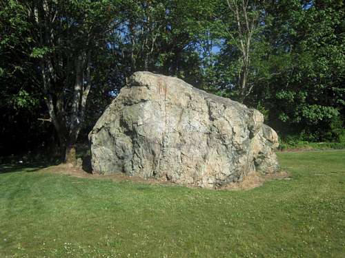 the north aspect the north aspect |
Getting There
From I-5 exit 183 for 164th St and head east, turn left on Meadow Rd and then right on 146th St, the park will be on your right.
Routes
These are what I would consider to be the seven best of the many routes and variations I have done. As I am not overly familiar with the Vermin system, I would welcome second opinions on these ratings.
Note: I have recently returned and re-climbed many of the routes, adding sit-starts to the West Corner, the South Rib, and the Southwest Corner (not pictured below, but visible in the west aspect photo above. For this reason some rating and names do not match the photos.
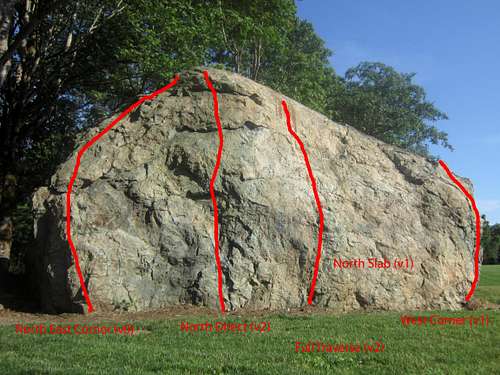
Takeoff [labeled North Direct] (v2+) - a difficult, somewhat delicate, route involving a series of underclings that ascends the steepest side of the high point. Without a crash pad a fall from the crux move could result in injury, making the finishing moves, which are not difficult once you find the right holds, feel a little desperate. This is probably the easiest route to top-rope solo.
North Slab (v1-) - climb a series of pockets, smearing in this low angle section is more secure than it may appear.
West Corner (v1+) - a short, overhanging route; one of the main holds is clearly loose, but doesn’t seem to be going anywhere. A sit start probably does not up the grade technically, but does adds 2-3 powerful moves right off the ground.
Southwest Corner (v1) - like the West Corner but shorter and not as overhanging, begins with a sit-start just left of the prow, a start to the right could be much more challenging.
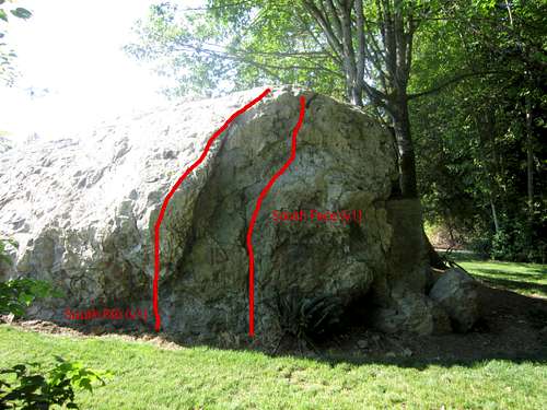
South Face (v1) - involves a slightly painful two-finger pocket.
South-East Corner (v1+) - a bit contrived, climb the features between the South Face route and the blocky edge of the east face; hands are good but you have to find the right feet.
Full Traverse (v2) - traversing this boulder without toping out and skipping moves can be challenging, particularly around the second (counter-clockwise) of the two west corners. For my own purposes I differentiate between the high traverse and the low traverse in the sections of the north and south faces where such options exist; thus far I have only been able to complete the route using the low traverse of the north face and the high traverse of the south face. The low traverse of the south face may very well be over v3, my attempts have been thwarted by loose rock on the footholds, and my inability to climb over v3. I have been too scared to attempt the high traverse on the north side without a crash pad(s).
Caveats and Warnings
Although I occasionally spot chalk stains, as far as I am aware the Airport Boulder is not a site frequented by climbers. Having lived in the area for most of the last 20 years, I have seen boulderers only a small handful of times; a large part of the reason I have created this page is to inspire others to change this pattern so that the following warnings do not need to be given.Beware of broken glass – a very popular skate park is a 30 second walk away. You make the connection. I pick up broken beer bottles every time I’m there.
Community relations – the Martha Lake Airport Park erratic is not considered a climbing location and I have gotten some very strange looks and comments from other users of the park, including one who assured me “don’t worry, she [the man’s three-year-old child] was was doing this [climbing the on boulder] before you got here.” Please be respectful of other users of the park and above all don’t get injured climbing! A ban on climbing here would not surprise me at all.