
|
|
Canyon |
|---|---|
|
|
35.16300°N / 83.014°W |
|
|
Mixed |
|
|
Spring, Summer, Fall, Winter |
|
|
Overview
Panthertown ValleyPanthertown Valley is a rare formation in the Southeast. Briefly, it’s a huge, U-shaped high elevation valley. This type of valley is extremely rare in the Eastern highlands, and especially rare when the area remains largely undeveloped.
Much of Panthertown Valley lies at, or just above 3,400 feet above sea level. It is surrounded by peaks that range from 4,000 to 4,800 feet. The valley floor is home to a number of rare high bogs and many streams cut through the valley before pouring out of the Panthertown area to tumble down the Blue Ridge escarpment to the east.
 Little Green dome.
The entire area from Highlands NC to Panthertown is often referred to as the “Yosemite of the East”. Not in least part because of the number of granite plutons that dot the region, and for the amazing number of spectacular waterfalls in this relatively compact vicinity. The two highest cliffs in the eastern USA are in this area, and the climbing opportunities are many and varied.

At several overlooks in and around Panthertown Valley, one becomes acutely aware of the climbing walls in the valley. At both Salt Rock overlook and on the cliffs of Little Green Mountain, there are large walls of granite to be seen in almost every direction. The valley remains a climbers delight, and yet is lightly visited. There are also great opportunities for whitewater rafting in the streams within this great valley.
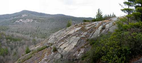
 Cliffs of Little Green Mountain.
In the mid-80s, when the undeveloped 7,000 acres of Panthertown were made available for sale, both the Nature Conservancy and the state of North Carolina expressed interest in nabbing this huge chunk of real estate so that it could be preserved as wilderness. However, the Duke Power Company, with its bottomless pockets, stepped in and grabbed the land before it could be preserved. They took a power line right of way that almost bisects the valley, into which they assembled a series of towers, and so what would otherwise be unbroken wilderness is cut by an enormous slash through the center of Panthertown. After Duke Power had taken their right of way and made this most painful cut, they “generously” sold off the remainder of the valley to the Nature Conservancy who then transferred ownership to the National Forest Service, thus grabbing a hefty period of good neighbor propaganda for the rapacious corporate titan.

Today, Panthertown Valley is a slowly recovering ecosystem. Long abused by timbering interests and the accompanying problems of wildfire and erosion, the forests there are just beginning to get back to something like normal. Of course the hemlocks trees there are doomed from the hemlock wooly adelgid infestation, but many of the other trees are doing well. The water table is relatively pristine and is home to native brook trout that ply the cold, clean waters to be found there. Panthertown is also good bear habitat, and coyotes have moved into the valley. High dollar real estate development encroaches on every side of Panthertown, and vistas that once revealed only unbroken forests now are marred by big homes sitting high on ridges owned by the wealthy elite.
Still and all, one can definitely find real solitude within the almost 7,000 acres of Panthertown. You won’t see or hear any panthers, but you will enjoy mountain vistas and amazing waterfalls and hear the sound of clear, free-running streams and cataracts. For something akin to a wilderness experience, Panthertown Valley is worth visiting.
 Schoolhouse Falls
Getting There
Directions East Entrance (Cold Mountain Road)From Asheville:
Take I-240 West to I-26 East to the Asheville Airport, exit 40. Turn right onto NC 280; follow this for 16 miles to Brevard. At the intersection with US 64/276, continue straight onto this dual highway. In downtown Breavard, US 276 heads right; stay straight on US 64. US 64 bears right after passing through brevard. Follow US 64 for about 15 miles (it becomes very curvy) to the intersection with NC 281; turn right. See below.
From Highlands:
Follow US 64 East to Cashiers. 13 miles past the stoplight in Cashiers, just past the Lake Toxaway dam, turn left on NC 281.
from NC 281, go 0.8 miles and turn left on Cold Mountain Road (the fire station is on the right). Proceed just under 6 miles up Cold Mountain Road; the road turns to gravel. At a sharp left turn, a sign will indicate the Panthertown parking is just ahead. It is 0.1 mile from the sharp left turn to a gravel road on the right signed for the parking area; the road is about 0.1 mile long and the parking area is just a wide spot at the end of the road.

Directions West Entrance (Salt Rock Gap)
From Asheville:
See above directions to NC 281, except continue past 281 on US 64 for 8 miles. Turn right on Cedar Creek Road, go 2.3 miles, then turn right on Breedlove Road. The parking area is at the end of the road in just under 4 miles.
From Highlands:
Take US 64 East to Cashiers. 2 miles past the stoplight, turn left on Cedar Creek Road. Go 2.3 miles and turn right on Breedlove Road. The parking area is at the end of the road in just under 4 miles.

Red Tape
None.Prime bear habitat. Hang all food. Keep food out of tents. Lots of coyotes in the area, too. Please do not build fires on the granite mountaintops. Also, do not clear old wood from these areas, and stay off of the rare plants that grown on the cliff faces and exposed rocky areas.

Camping
As these are National Forest lands, you can camp just about wherever you damned well please. Just use common sense. Don't camp in low areas that are prone to flash flooding.
External Links
National Forest Trail MapHiking in Western NC
NC Waterfalls
Nature Conservancy