
|
|
Area/Range |
|---|---|
|
|
Hiking, Mountaineering, Ice Climbing, Scrambling |
|
|
Spring, Summer, Fall, Winter |
|
|
820 ft / 250 m |
|
|
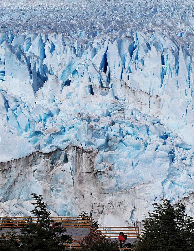

The Perito Moreno Glacier is a glacier located in the Los Glaciares National Park in the south west of Santa Cruz province, Argentina. It is one of the most important tourist attractions in the Argentine Patagonia.
The 250 km2 (97 sq mi) ice formation, and 30 km (19 mi) in length, is one of 48 glaciers fed by the Southern Patagonian Ice Field located in the Andes system shared with Chile. This icefield is the world's third largest reserve of fresh water.
The Perito Moreno Glacier is one of only three Patagonian glaciers that is growing. The reason remains debated by glaciologists. The terminus of the Perito Moreno Glacier is 5 kilometres (3 mi) wide, with an average height of 74 m (240 ft) above the surface of the water of Lake Argentino, in Argentina. It has a total ice depth of 170 metres (558 ft).
Periodically the glacier advances over the L-shaped "Lago Argentino" ("Argentine Lake") forming a natural dam which separates the two halves of the lake when it reaches the opposite shore. With no escape route, the water-level on the Brazo Rico side of the lake can rise by up to 30 meters above the level of the main lake. The enormous pressure produced by the height of the dammed water finally breaks the ice barrier holding it back, in a spectacular rupture event. This dam/rupture cycle is not regular and it recurs naturally at any frequency between once a year to less than once a decade.
The glacier first ruptured in 1917, taking with it an ancient forest of arrayán (Luma apiculata) trees. The last rupture occurred in July 2008, and previously in 2006, 2004, 1988, 1984, 1980, 1977, 1975, 1972, 1970, 1966, 1963, 1960, 1956, 1953, 1952, 1947, 1940, 1934 and 1917. It ruptures, on average, about every four to five years.
The Perito Moreno glacier, located 78 kilometres (48 mi) from El Calafate, was named after the explorer Francisco Moreno, a pioneer who studied the region in the 19th century and played a major role in defending the territory of Argentina in the conflict surrounding the international border dispute with Chile.
Due to its size and accessibility, Perito Moreno is one of the major tourist drawcards in southern Patagonia. It is less than two hours by bus from El Calafate, and many tour companies run daily visits. A large visitor centre at the site features a walking circuit which allows both faces, and the surface of the glacier to be seen. There is also a restaurant at the site.
In recent years, trekking tours on the ice have gained popularity. The two standard tours are a "mini-trekking" option, consisting of a short walk of about an hour and a half, and a "big ice" version, which is usually about five hours. Tour companies generally provide crampons to customers.

Strong waters, if people get into these waters, good chance of death.

Now the glacier without landscape, just ice!
To read...cool info

Atop Perito Moreno looking at a blue river
The Perito Moreno glacier also has several unique features. For one thing, it is, at the moment (according to some experts, at least) the only glacier in the world in a state of equilibrium—neither advancing nor retreating. Retreating is the norm, due to global warming—numerous glaciers have disappeared in recent decades, and many others are shrinking rapidly. The Perito Moreno glacier, however, advances at the same rate ice breaks off, and has done so for many years.
Its neighborhood Upsala glacier, a lot bigger, is melting very rapdly and at the last 12 months it lost 1km of its ice, very very fast.
Getting There
From El Calafate city/ Patagonia Argentina/ several agencies drive you up there, no need to drive by yourself but if you want to, very well signed way. From El Calafate it is only around 40 miles drive.Red Tape
Forbidden to hike this glacier by yourself since it is a natural wonder of the world, mandatory agency authorized guide. That sucks but it is probably for the best...Some links to find yourself a company to book the trekking, although it's not a big deal since every single agency at the city does the tour:
http://www.todocalafate.com/english/elcalafate_activities.php
http://www.interhabit.com/el_calafate/el_calafate_tourist_information_11.htm
http://www.allaboutar.com/ard_cala.htm
http://www.hieloyaventura.com/2010/eng_index.htm
(probably the best in town, I used this one)
http://www.tanguitotravel.com/plan-a-trip/excursion/ice-trekking-on-the-perito-moreno-glacier
http://www.adventureworld.com.au/tours-and-destinations/south-america/latin-america/argentina/tours/el-calafate-perito-moreno-glacier/
Camping
Just after the river cross on a boat, you will reach a refuge in which is possible to sleep. Before the cross there is a camping just before the Lengas forest, very cool place to see wild animals such as beavers, bunnies...Legal Issues
To hike/ climb is a dangerous activity and requires proper equipment and clothing, the owner of this page cannot be blamed by injuries caused to anyone who read this page for its info about the mountain, and eventually got hurt by doing so with reckless behaviour or bad weather conditions.
Paulo Roberto Felipe Schmidt – AKA: PAROFES
External Links
A brazilian website to get mountains info, including gps files to download:http://www.rumos.net.br/rumos/My youtube channel: www.youtube.com/parofes - Now with 260+ videos online!
The biggest brazilian website about climbing and mountaineering, for which I'm a columnist: