
|
|
Mountain/Rock |
|---|---|
|
|
40.52951°N / 116.06056°W |
|
|
Elko |
|
|
8282 ft / 2524 m |
|
|
Overview


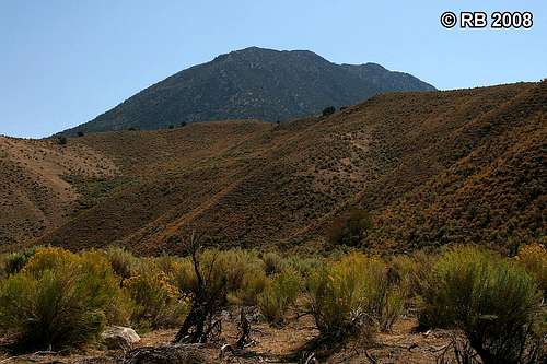
Pine Mountain is located in the Piñon Range south of Carlin in northeastern Nevada, about 28 miles southwest of the city Elko. Its elevation of 8,282 feet (prominence 742 feet) makes it only the sixth highest peak in this small range and is probably a big reason why it’s not a highly sought after summit objective, especially in a region in close proximity to the more popular Ruby Mountains. Pine Mountain has “curb appeal” though, especially when viewed from the west where this massive ridge towers 3,000+ feet above nearby Pine Valley. The north one-third of the Pine Mountain ridge is on private lands, while the remaining two-thirds to the south, including the summit, are on BLM administered lands. Surprisingly, I was not able to find much information on the WWW about this mountain.
The summit provides outstanding 360-degree views of a vast and remote region of the state. Centrally located in the Piñon Range, you can see the range, almost in its entirety, north to south. To the west and southwest lie Crescent Valley and Pine Valley, respectively. The Ruby Mountains are about 30 miles to the east.
 Summit view to E. Summit view to E. |
 Summit view to N. Summit view to N. |
 Summit view to NW. Summit view to NW. |
Getting There
From Interstate 80, take NV-221 (exit 280) south at Carlin. Proceed 0.25 miles south, turn left and proceed west through Carlin another 2.7 miles on NV-221/Chestnut Street. Turn left (south) onto NV-278 and proceed south for about 14.7 miles, then turn left (east) onto the dirt access road. You will see a Tomera Ranch “private property” sign. Continue past this sign through Ferdelford Canyon (along Ferdelford Creek). The road heads in a northeast general direction to the north side of Pine Mountain, where it changes to a southeast direction then winds south through the Piñon Range. The route on the dirt access roads is 13.2 miles in length and through a combination of BLM administered land and private property, much of it through the sprawling 70,000-acre Tomera Ranch. Please stay on the designated access roads and treat both the private and public lands with respect. Also, drive with caution as this is an open range area.
There are many roads in and around the Piñon Range and it can be easy to take a wrong turn. A good topo map of the area could be invaluable. Pine Mountain, although not the highest mountain in the range, is visually the most prominent. It also has significantly more trees on its slopes, particularly on the west side, than the other peaks in the area. The road in will pass to the north of Pine Mountain and wind around down the east side of it about three miles distant. When northeast of Pine Mountain, you will pass by a radio tower facility, which will be on the left (north) side of the road. Pass by the northwest ridge of Bunker Hill then follow the road as it curves to the northwest; park it the area just west of the summit of Point 8525 B. The latter portion of this route requires 4WD and high clearance.
The below topographic maps show the driving and hiking route for Pine Mountain.
 Route map 1 of 3. Route map 1 of 3. |
 Route map 2 of 3. Route map 2 of 3. |
 Route map 3 of 3. Route map 3 of 3. |
Route to Summit
The cross-country trek to Pine Mountain is a negative-gain route, with a starting elevation of 8,378 feet and ending at the summit at 8,282 feet. The basic route starts in the shadows of Point 8525 B and runs west along the ridge connecting Point 8525 B with Pine Mountain. There is not a use trail on this route, but I did see several game trails that could be followed for short distances. There are several ups and downs on the route which account for a gross elevation gain of 872 feet on the ascent and 986 feet on the descent. The final section of the ascent route involves a 742-foot gain from the saddle up the east slope through moderate density mountain mahogany and piñon pine woodlands. The three upslope sections of the descent route involve gains of 252, 200, and finally 534 feet at the end. The route is a mixture of Class I and Class 2 that involves crossing over shrub and grasslands, shale, scree slopes, and woodlands.This route is 4.1 miles round-trip with a gross elevation gain of 1,858 feet.
 Ascent view 1. Ascent view 1. |
 Ascent view 2. Ascent view 2. |
 Ascent view 3. Ascent view 3. |
 Descent view 1. Descent view 1. |
 Descent view 2. Descent view 2. |
 Descent view 3. Descent view 3. |