
|
|
Mountain/Rock |
|---|---|
|
|
32.84767°N / 108.23898°W |
|
|
Grant |
|
|
7609 ft / 2319 m |
|
|
Overview

Point 7,609 is located in the Pinos Altos (Spanish for "tall pines") Mountains (not to be confused with the nearby and larger Pinos Altos Range) west of the small town of Pinos Altos and north of Silver City, just beyond the borders of the Gila National Forest in southwestern New Mexico. Point 7,609 has a prominence of 309 feet and can be easy to miss were it not for the maintenance road leading to its summit, where there are several radio towers and maintenance buildings. This peak lies 1.5 miles southwest of Pinos Altos and is one of two peaks (the other is Pinos Altos Mountain) in this small range with a drive-up summit.
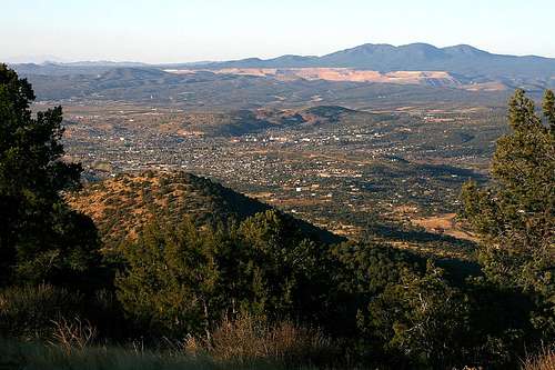
While the summit doesn’t have great 360-degree views, it does offer what is arguably the best view in the area of Silver City, which is less than five miles south of the summit and 1,700 vertical feet lower. So is it worth the drive up? In a word, yes!
Getting There
From U.S. Highway 180 just east of Silver City, take NM Highway 15 north for about 6 miles. About 0.3 miles south of Pinos Altos, turn left (west) onto the dirt road (marked “Radio Tower Road”). You will need to travel about 2.5 miles on this road to reach the summit. After going about 0.8 miles on this road, it will split -- stay to the left. 0.4 miles later, stay to the right where the road splits again. You will come across two intersections (that lead to Pinos Altos Mountain) about 0.2 miles after that where you will continue going straight. There will be a final intersection about 0.8 miles later after passing by Point 7,609 on its east side. Stay to the right and the road will lead to the summit from the south side.I recommend a high clearance vehicle for this route; I don’t think 4WD is necessary. A car might be able to reach the top, but I would recommend against it.
NOTE: Topographic maps do not show some of these 4WD/maintenance roads, such as the last three intersections described above.