
|
|
Route |
|---|---|
|
|
46.48358°N / 9.91750°E |
|
|
Ice Climbing |
|
|
Winter |
|
|
Most of a day |
|
|
WI 3 |
|
|
7 |
|
|
III |
|
|
Overview
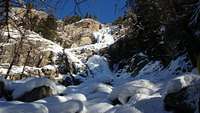 Pontresina Fall
The Pontresina Fall belongs to the classic ice falls of the Engadin, the upper Inn valley in the southeast of Switzerland. The 270 m high, southwest exposed fall offers pleasant climbing in 60-80° terrain (WI 3) over 7 pitches. There exists also a variation, known as the "Left Route" (III M5 WI5) for pitches 2-4.
Take care with much new snow and warmer temperatures, also during the course of the day. The fall rises from the altitude of 1940 m to 2180 m. Best conditions mid-January to mid-February.
Getting There
 Approach
From Chur over the Julier pass to Pontresina or from Austria following the Inn valley. Trains operate from Chur to Pontresina with a changeover in Samedan. Nearest train stop to the fall is Surovas, one stop behind Pontresina.
Along the Via da Bernina, 650 m southeast of the city of Pontresina to a public parking lot (parking meter, ca 1 CHF/hour) at the company Seiler (1827 m).
From the parking lot follow the slope through the forest directly to the fall (30 min).
Route Description
 Route
RoutePitch 1: 45m 75°. The climb starts at 1940 m with a 75° step which also can be bypassed flatter on the left (60°) or steeper on the right (80°). Belay with bolts below the slightly overhanging rock roof on the right. At this point the "Left Route" (III M5 WI5) branches off, aiming at the free-standing pillar on the left side of the Pontresina fall.
Pitch 2: 45m 50°. Round the corner and along the snowy ramp to a small cave on the right. Bolts can lay under ice. Eventually an ice column in the cave can be used for belay, if it's massive enough.
 First pitch
Pitch 3: 50m 80°. The second step directly (80°) or easier on its right side close to the rock (75°). Belay with bolts on the right wall.
Pitch 4: 30m 65°. Homogeneous terrain along a small rise. Head for the gully on the the right. Belay below it, bolts maybe under ice.
Pitch 5: 40m 65°. Either by the 65° gully or directly, but steeper, to the rock in the middle of the fall. Some lower angled meters lead to the bolted belay on the right. From here you can rappel down or continue to the end of the fall with another two pitches 60° ice with two nice steps, but some snow between.
Pitch 6: 50m 60°. Follow along easy snow covered ice to a small step (80°). Above again a snowy slope. The fall now turns more to the right. Belay on ice screws below the next step.
Pitch 7: 50m 70°. Climb a last step directly (70°) or along a nice face close the left wall (80°). Follow the narrowing stream with some snowy passages as the terrain lays back. Belay on the trees above the fall at ca 2180 m.
Descent
Descend either by a trail northwest of the Pontresina Fall or rappel down the fall, especially when there's much snow.Trail: Traverse to the left for approximately 100m until you reach the "Röntgenweg" trail, named by Wilhelm Conrad Röntgen, who discovered 1895 the X-rays and spent many summer holidays in Pontresina. This trail often is tracked even during winter and leads back to Pontresina in 30 min. As you reach a turn-off at 1840 m, follow the trail to the right to reach the Santa Maria church and Pontresina or the trail to the left to get back to the parking lot.
Rappel: Use trees or Abalakov threads to abseil pitches 6 and 7. There are only bolted belays in the lower five pitches located on the eastern edge of the fall, though some of them maybe buried under snow or ice. Additionally there are some trees on the right side of the fall, evaluation of stability is necessary.
Essential Gear
Regular ice climbing equipment (ice tools, crampons, helmet), 10 ice screws, 60 m double ropes, cords.Additional Information
 Hot Ice - Eisklettern in der Schweiz
Great guide book for 95 ice climbing areas in Switzerland - simply the reference.
Urs Odermatt, issue 1, 2005, ISBN 978-3-033-00635-5.
CHF 39,90 / € 29,80 / US$ 39,-
 Schweizer Landeskarten - Blatt 1257 St. Moritz
 Map scaled 1:25,000 by the Swiss Federal Office of Topography.
ISBN 978-3-302-01257-5.
CHF 14,- / € 10,90 / US$ 13,50 (discount for SAC members)
Link: SAC Online Shop
External Links
MapPlusFree online version of the Schweizer Landeskarten maps.
http://www.mapplus.ch/...
bergtour.ch
Information about mountain conditions in the Alps.
http://www.bergtour.ch/...
MeteoSwiss

Weather forecast for Switzerland by the Swiss Federal Office of Meteorology and Climatology.
http://www.meteoswiss.admin.ch