
|
|
Mountain/Rock |
|---|---|
|
|
34.46950°N / 111.8752°W |
|
|
Yavapai |
|
|
Spring, Fall, Winter |
|
|
6525 ft / 1989 m |
|
|
Overview
Porcupine Mountain is located south of Camp Verde. It is named "Squaw Peak" on topographic maps. The name "Squaw" is a derogatory term, which is the reason for efforts to change the name with USGS and the reason the mountain was officially changed to Porcupine Mountain in 2022.
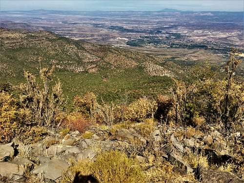
Porcupine Mountain is interesting because it resides high enough to have a forest but situated where it has views to desert topography far below its lofty summit.
Porcupine Mountain has 1,385’ of prominence, which makes it a wonderful vantage point.
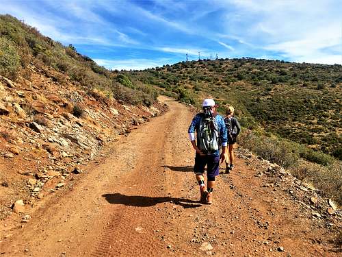
The mountain is a popular spot for ATVs and is a great destination for trail runners or mountain bikers. The summit is 10 1/2 miles off of I-17 via the 68D Forest Road, so it is easily accessible. However, after a few miles, the road deteriorates and a little past 5 miles, the road starts climbing and 4WD is preferred.
The true summit is located behind the last tower furthest east. From the true summit there are sweeping views of the Mogollon Rim. However, the summit area itself is broad, and from various vantage points there are excellent views towards Sedona, the Bradshaw Mountains and other mountains around Prescott, and even views towards the high peaks around Flagstaff. Quite simply, from the summit, you can peruse much of Central Arizona.
There are a couple other summits that can be reached from the 68D Road on the way to Peak 6,525. These include Peak 5,889’ and Bald Hill 6,089’ (which located about 4 miles west). These summits can be done in combination and require easy off-trail hiking with about 2 ¾ miles of round-trip hiking.
Porcupine Mountain can be hiked any time of year, since it is along a dirt road and relatively accessible. Avoid the road after rainstorms. The ideal time to hike here is probably March-May; September-November.
Getting There
To reach the mountain, take I-17 to the exit for Arizona Highway 169. Once on the exit, drive east and the pavement ends after a tenth of a mile. This becomes the 68D Road. Porcupine Mountain is about 10 ½ miles from I-17. There are signs pointing towards the summit along the way. 4WD can reach the summit.
Red Tape
There is some private land along the 68D Road. Be mindful of signs, and park where appropriate.