
|
|
Mountain/Rock |
|---|---|
|
|
38.11947°N / 107.53523°W |
|
|
Hinsdale |
|
|
Mountaineering |
|
|
Summer |
|
|
13144 ft / 4006 m |
|
|
Overview
 Precipice and Dunsinane (by Liba Kopeckova)
Precipice Peak, aptly named for the perilous cliffs nearly encompassing its summit, provides magnificent views of the surrounding Cimarron peaks of the famed San Juan Mountains of Colorado.
To the north, Dunsinane and Turret Ridge rise prominently over the West Cimarron Valley and the Gunnison River valley beyond. To the west, Chimney Rock and Courthouse Mountain provide stunning contrast to the aspen foliage surrounding Ridgway and Owl Creek Pass. To the east, the views of El Punto and other spectacular peaks are enough to inspire trepidation and anticipation. To the south, Fortress, Redcliff, Coxcomb, Uncompaghre, and Wetterhorn loom ominously, appearing unclimbable from these aspects due to a series of rotten hoodoos and rugged cliffs.
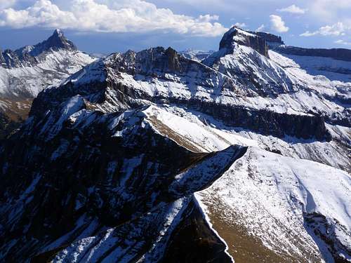 View to the south
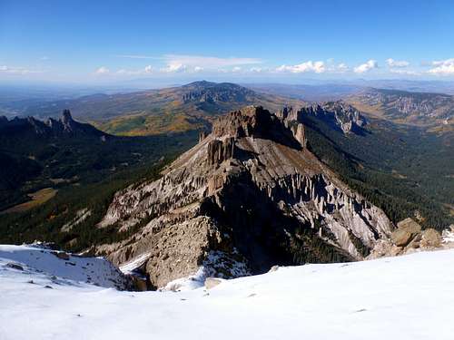 Dunsinane, et. al.
And indeed, most of these peaks have seen few, if any, ascents from the north. A fact mostly attributable to rock of horrendous quality - volcaniclastic remnants of Colorado's more explosive past.
 Unclimbed Uncompaghre's N face in shade
Getting There
West Cimarron TrailheadThe trailhead can be accessed from either US-550 just north of Ridgway and south of Montrose (western approach) or from US-50 between Gunnison and Montrose (northern approach). The northern approach is faster from Denver, though the I-70/550 route might be safer in evening deer terms. Both approaches are maintained dirt 2wd with the final 2 mi requiring high clearance, easy 4wd.
Directions here: Directions
Route - Western Slopes
Precipice is typically accessed via its western slopes. A traverse from Fortress is a daunting task requiring navigation of a large, loose cliffband and a series of hoodoos. The hoodoos can be bypassed by dropping a couple hundred feet. However, the cliff band would require sketchy rope work. Both peaks are best hit from the road. Precipice from the Fortress difficulties
Western Slopes: Brief class 3, ~3 mi RT/2500' (est.)
From the 4wd trailhead, follow the prominent debris flow/avalanche chute east towards a grayish, rocky chokepoint in the gulch where one begins climbing north/left. Prior to the outcrops/chokepoint, a savy hiker might spot a number of game trails gaining the left ridge. The game trails are highly recommended for alleviating a couple hundred feet of steep bushwacking.
Once the slope relents, climb east/right along the northern margins of the prominent chute. Again, social trails wind their way through the deadfall.
The trees will quickly give way to talus and tundra where a couple route options are present. The first option is slightly more difficult, but faster and less tedious.
1) Climb steeply NE until reaching the base of a cliff with a number of shallow caves at the base. Move right/east until reaching a break in the cliff after a loose section and continuing steeply NE (class 2+). Cairns are visible leading one east across a couple minor gullies before ascending tundra NE towards Precipice's south ridge. Aim right of the large towers.
2) Continue east along the left side of the prominent chute and curl around a bulk of rock on its right side (class 2). Hook a left on tundra towards the saddle, aiming right of the towers.
 Tundra to ridge
Briefly move north along the ridge before aiming NW towards an obvious notch between two large towers. A decent trail picks up here.
After passing the notch (class 3), continue ascending north along the ridge until reaching a false summit (class 2). From the false summit, hike east/right briefly to the true summit (class 2+).
 Notch from other side
Enjoy the views of the surrounding peaks before descending via the same route.
 Wetterhorn
Red Tape
The peak is located just outside of a wilderness area. Still, use common sense and practice LNT ethics.Camping
Developed campgrounds are located near Silver Jack Reservoir. Several meadows near the end of the 2wd section provide excellent free camping.External Links
ListsofjohnAlbum
14ers.com TR
metal4lyf - Aug 7, 2016 9:19 pm - Voted 10/10
Precipice-Fortress TraverseIt is possible to combine Precipice and Fortress via an easy class 2 traverse. From Precipice, continue along the south ridge over the first prominent bump and up the second one. Leave the ridge from the top of the second bump, descending south on steep, grassy slopes into a narrowing gully. Pass through a break in the cliffs at the bottom of the gully and continue southwest on talus and grass towards an obvious bluish hoodoo garden. Pass the blue hoodoos on the left and contour at 11800' across grassy meadows, intersecting the normal route on Fortress below the prominent cliff on its west ridge. This is a very scenic alternative to descending to the car, and it saves around 1000 feet of gain. It could be reversed easily, but I think clockwise is the way to go. Topo map here: http://www.summitpost.org/precipice-fortress-traverse/979243