

|
|
Mountain/Rock |
|---|---|
|
|
46.89827°N / 9.34320°E |
|
|
Mountaineering |
|
|
Spring |
|
|
10653 ft / 3247 m |
|
|
Overview
The Ringelspitz is the highest peak in the canton of St. Gallen even though its summit is divided between the cantons of Grisons and St. Gall.It's located 12km NW of Chur, the capital of Grisons.
You can climb the mountain during the whole year, although the best season is winter (as a mixed ski/ice/rock climb) and early summer (when there is still snow and the couloir is icy).
It is recommended to do it as a two days tour. The start from the tour is at the SAC (Swiss Mountaineering Club) Ringelspitz hut.
Here is a regional map:

Getting There
Getting to the RingelspitzhutThe closest access village is Tamins, which lies just about 10 minutes to the west of Chur. If you arrive with your own car, you can park there. Make sure you pay the parking fee, otherwise you will get a ticket.
If you arrive by public transportation, take the regional bus at the Chur Bus and Trainstation, direction Laax. It is a yellow bus. If you need assistance, ask one of the bus drivers they are very friendly and help you.
Once you have arrived in Tamins you have two options how to get to the Ringelspitz hut.
Option 1: via the "Lawoivalley"
Go to the northern end of Tamins where the forest starts. There are clearly marked trails (yellow sign). The Lawoi route is much harder (because it's very steep) but very nice and picturesque. The trail is very well maintained. Approx. time to the hut is 4 hours.
Option 2: via the mountainroad and "Kunkels" pass
Also from the northern end starts a mountainroad which is only for the forestry service. But you can walk on it all the way to "Kunkels" pass. If you have your mountainbike with you, you can bike all the way up to the pass. From the pass you take the NW route (marked with yellow trail signs) to the Ringelspitz hut. Approx time to the hut is 4 hours.
The Ringelspitz hut
The Ringelspitz hut is beautifully located and offers a very nice view of the surroundings.Here is the website of the hut:
SAC Ringelspitz hut
Unfortunately it's only in German, so I put the most important infos:
The hut has 40 Beds. On weekends, there is the hut warden there, which also cooks. If you come during the week or during off season, there is only a small room with 12 beds open. Prices are on the website.
Make sure you reserve your place in advance. Especially if you want to come during peak season (june-august).
Contact information of the hut warden:
Mr. Marcel Manhart
Serra 2
CH- 7315 Vättis
Switzerland
Tel. +41 (0)79 632 24 34
e-mail: info@ringelspitz.ch
It is not advisable to camp around the hut, since it is officially not allowed.

The Ringelspitz
There are many variations of routes but the best is for sure through the couloir or the middle-ridge.Getting to the base of the peak
From the Ringelspitz hut you follow the trail to the NW which lies in a small vaalley until you get to a small plateau called "Sandboeden". Turn to the W and shortly after N, you will see the couloir and the middle-ridge. All the way up the valley you can see the very distinctive peak.
If there is enough snow in spring, take your snow shoes to get to the base. In winter you ski up all the way to the base.
The climb
Even though it's not that much left of a glacier, you stand on the "Tamins Glacier". Ther are no crevasses left where you could fall in, but ther are some knee breaking holes, so watch out!
The couloir is about 42 degrees steep but offers very nice climbing, especially during spring and early summer. Go all the way through the couloir until you get on a ridge. From there turn W and do the last meters of rock climbing. There is a fix iron cable, which doesn't help much but still you can secure yourself on it. After this you stand on the summit.

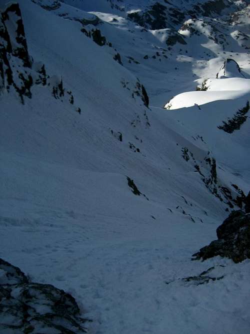
The middle-ridge is just E of the couloir. So you can either ascent trough the couloir and descent via the middle-ridge or vice versa. Or ascent and descent only through the couloir or the middle-ridge.

Be carefull in summer. The couloir gets really fast snow-free and everything which slides....well slides!. During summer the middle-ridge is definetly the better option.
On the summit you have a marvelous 360 degree view.
To the E you can see the "Panaerahörner", to the N the Gigerwaldlake and the very, very steep N-face of the Ringelspitz. To the S is the valley where you came from and to the W the "Galserhorn" and "Tristelhorn".
You see als in the Chur Rhine Valley (SE) and up to the Surselva Region (NW).
The descent is as described via an ascent route. Also getting back to the hut is basically the same way.
Other options
If you are early at the hut you have several things which you can do:About 10 minutes walk behind the hut is a well maintained climbing wall.
It offers 10 routes in various levels (UIAA 4 - 7).
In case you are a wildlife buff, bring you binoculars with you. Just E of the hut there are several grass/stone walls where in spring and summer lots of ibexes climb and eat. You can sit on one of the benches outside the hut, enjoy the sun and observe the fascinatingclimbing of this four footed freinds.
For those who still want to hike, SE of the hut is annother nice viewpoint called "Saessagit". Follow clearly vissible ridge from the hut until the ridge is finished, there it is. Beware of slippery terrain when it's covered with snow or is wet form the rain. Falling down there is a few hundred meter drop and there is no good way to secure yourself. So watch out.
Useful information and links
Maps:Swiss Topo Maps 1:25'000 Number 1175 "Vaettis" and Number 1195 "Reichenau".
Tamins and the Ringelspitz hut are on the Reichenau map, the Ringelspitz is on the Vaettis map.
Ringelspitz hut:
The hut
Public Transportation:
Transport
also in English (for trains and busses)
Weather:
Meteo
also in English
Avalanche Report:
Avalanche
Mountain Rescue:
Telephone Nr: 1414 (free number diable from every phone and cellphone)
Red Tape
Camping is not forbidden in the area but makes no real sense, since the hut offers very cheap accomodation, plus you can leave your stuff which you won't need for the climb there. Around the hut, it's forbidden to camp.Parking is available in Tamins, do not drive the forestry road since it's only for forestry service and locals. You will get a fine if your park along the road.
Permit for the mountain is not required.
Be carefull with climbing the couloir if there is not enough ice and snow, rockfall is very likely.