
|
|
Route |
|---|---|
|
|
17.6187°S / 149.50101°W |
|
|
Hike/scramble with fixed rope sections |
|
|
A few days |
|
|
Class 3, but slippery |
|
|
Approach
Despite the fact that the mountain is right next to the capitol city of French Polynesia, it isn’t that easy to get to the trailhead at Le Belvedere. There are several ways to get to the restaurant at the trailhead.Walk
If you are alone and have three-days to spare, you can walk to the trailhead. This is 10 kms/6.2 miles each way from downtown Papeete. You can shorten the walk by 3 kms/2 miles each way by taking a bus east from Papeete to the suburb of Parae.
Walk or take a bus to east of the Hippodrome stadium in Parae. This is about 200 meters/700 feet east of the Total Gas Station. From there, keep an eye out for the signs pointing out the road to Le Belvedere. There are several turns, but there are signs for the restaurant at every intersection. Follow the poor paved road to the restaurant (7 kms/4 miles from Parae). The restaurant and trailhead is at 600 meters/1970 feet elevation, and is a hot walk.
If you are lucky you may catch a ride to the restaurant, but don’t count on it.
Drive
Follow the directions above, but rental cars are very expensive on Tahiti. Parking can be a problem at the trailhead if you are not eating in the restaurant.
Restaurant Shuttle
If you have two or more people, the restaurant will pick you up, assuming of course, that you eat in the restaurant. The meals aren’t cheap, but are really no more than they are in the other upscale restaurants in Tahiti. Any travel agency along the main avenue in Papeete can hook you up with a shuttle. Make sure to let them know you are climbing the mountain and want to take the shuttle down the same day. You can also try calling the restaurant directly at 42 73 44.
Update:
The original restaurant "Le Belvedere" closed in 2013, changed owners in 2014, and is now open as "O Belvedere" as of 2015. It's unclear as to whether or not it still operates a shuttle... my guess is no, but they can be contacted at +689 89 403 403 or via email at contact@o-belvedere.com. Click here for the Restaurant Website.
Taxi
If you have the cash to spare, a taxi will take you to the trailhead, for $65 each way. It’s almost cheaper to eat in the restaurant and take the shuttle unless you have a group of more than three people.
Route Description
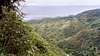
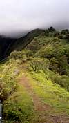
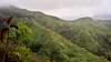
There is a large sign at the trailhead, so you can’t miss it. The trail is also next to the French Army Training Center. The trail climbs steeply up the ridge to the south. There is no water on the ridge, but you will hear many springs and waterfalls down below on either side of the ridge. You will notice several fixed ropes on some steep sections. If you are climbing the mountain when the weather is dry, you may question why the ropes are there, but try coming down the trail in the rain! It’s super slippery!Updates from SP member dballistic:
There is also a 10 foot section where the trail is gone due to a landslide that started right at the trail's edge. We were able to get around it on the steep right side of the trail by grasping grass for handholds while - but even by the time we returned we felt like the grass was getting pulled up and the handholds wouldn't last for long. Without them there's not a way to cross the chasm. Hopefully a local will install a rope to make it safely passable. I'd suggest wearing light long pants for this, as the trail is overgrown with bushes in many places and our legs got pretty scratched up.
The trail strays from the ridge in a few places and goes through a wonderful and dark rainforest before regaining the ridge. The first hut, Fare Mato is at 1400 meters elevation and is just after a steep section. The most difficult section of the climb is not far beyond the hut. You must climb up and along a fixed rope section, and it will be slippery if it has rained recently, or if it is raining. Fare Ata hut is at 1800 meters and is 8.6 kms/5.4 miles from the trailhead.
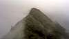
From the Fare Ata hut, the trail climbs along the knife-edge ridge to the summit of Aorai. If the weather is clear, you will have some great views of Papeete, the ocean, the island of Moorea, and many of the extremely steep surrounding peaks. The summit is 10.6 kms/6.6 miles one way from the trailhead.


T. White - Dec 30, 2017 1:25 am - Hasn't voted
Restaurant updatesThe original restaurant "Le Belvedere" closed in 2013, changed owners in 2014, and is now open as "O Belvedere" as of 2015. It's unclear as to whether or not it still operates a shuttle... my guess is no, but they can be contacted at +689 89 403 403 or via email at contact@o-belvedere.com. Website is http://www.o-belvedere.com/en/
Scott - Jan 4, 2018 3:31 am - Hasn't voted
Re: Restaurant updatesThanks for the updates. I will add them to the page.