
-
 10041 Hits
-
 74.01% Score
-
 4 Votes
|
|
Route |
|---|---|
|
|
38.30620°N / 78.7038°W |
|
|
Hiking, Trad Climbing, Scrambling |
|
|
Spring, Summer, Fall, Winter |
|
|
Half a day |
|
|
5.2 (YDS) |
|
|
Overview
The cliffs at Big Run really are a destination themselves, but they are not officially named on park or USGS maps, and I think it would be inappropriate to make a mountain/rock page for them. Therefore, this is just a route page, but I hope it will pique some wilderness-climbing lovers’ interest.
This route takes you into one of the most remote trail-accessible areas in the park. It is not the only way to reach the cliffs of Big Run, but it does give the chance to bag two interesting peaks en route.
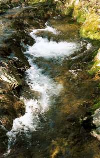
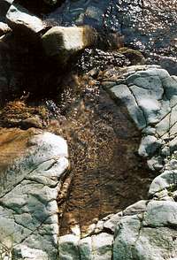
The main attraction, and the reason for making this page, is the cliffs around the lower end of Big Run. These cliffs, which rise 50-100’ above Big Run, are numerous and are not contiguous. The ones closest to the stream and the trail are on the north side of Big Run. Unlike the rock on cliffs in the Central District of the park, the rock here is loose; the cliffs’ compositions often remind me of those New England rock walls built of flat, non-cemented slabs of rock that look just as pretty as anything but which pull out so, so easily. For that reason, I wouldn’t feel comfortable relying on fixed protection and ropes here, but that’s your call. I recommend doing what you can by your own skills and your body alone. In my opinion, that makes it more fun, anyway.
Some of the cliffs will be too sheer, loose, or both for most people to want to try unroped, but keep an eye out and you will find something suitable sooner or later. The ones I climbed were close to the junction of the Big Run Portal and Rocky Mountain Run Trails, and the climbing was mostly Class 4 with a few Class 5 moves. Again, the trouble is the stability of the rock, so exercise due caution; this stuff does break off right in your hands and under your feet. However, it’s fun, and you can bushwhack down, though expect dense stands of mountain laurel, and watch for poison ivy. In other words, avoid the place in summer and wear pants and long sleeves. Otherwise, prepare to itch and bleed.
POACHERS ALERT! An unfortunate and ugly reality of Shenandoah’s backcountry in recent years has been the increasing presence of bear poachers. The poachers usually just cut off the paws and remove certain organs while leaving the rest of the carcass to rot. The Chinese belief in the efficacy of aphrodisiacs and medicines derived from ivory-bearing animals, tigers, and bears is the primary driver of the black market that threatens both to exterminate tigers and rhinoceroses and substantially deplete the numbers of other animals (such as black bears)— for example, after a period of decline, elephant poaching is again on the rise in Africa.
But my real purpose here with this, before I go too far off the topic, is to warn you that although it’s unlikely, you could encounter a poacher in this part of Shenandoah since it is remote and lightly used yet still served by a good trail system. The poacher will be armed, and, since he is knowingly engaged in criminal activity, he should be considered dangerous. Don’t challenge or follow him. Take good note of his appearance and location, perhaps even pretend to condone the fact that he’s out with a gun in a national park (he probably won’t have his kill out in plain sight), and then report his ass to rangers as soon as you can. I can’t incite you to commit a felony, but if you’re armed yourself (illegal here, though) and the poacher happens to suffer an “accident,” I certainly won’t think poorly of you.
Getting There
Enter Skyline Drive and drive to the Brown Mountain Overlook, just north of MP 77. This is the trailhead. There is no public access to Big Run in Shenandoah National Park from its lower end.Route Description

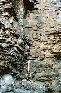
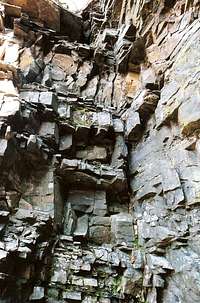

For climbing info, click on the cliff photos in this section.
Total Distance (trails only): 10 miles
Total Elevation Gain (trails only): 2100’
For 0.7 miles, Brown Mountain Trail drops 450’ to its junction with Rocky Mountain Run Trail. Continue straight ahead, though, and 0.9 miles and 450’ will get you to the first, and lower, of Rocky Mountain’s summits (2800’). The lower summit has the better views and rock outcrops, and scramblers can have plenty of fun here. After another 0.6 miles of hiking takes you past, but not onto, the higher summit, which requires a short off-trail hike to reach. If you’re interested in Brown Mountain and looking for its fossilized wormholes, that 2500’ summit is another 0.9 miles away.
After the summit of Brown Mountain, the trail descends steeply to Big Run. At times, you might think you’re in the Carolinas, Georgia, or even certain places in the West because of the dominance of pine trees and sandy soils. During the descent, there are great views of Rockytop, its talus fields, and some of the cliffs above Big Run; but for something even better, look northeast; jutting starkly from the nearby slopes will be some huge unnamed cliffs that no trails reach. Because of the difficulty involved with reaching those cliffs, it would not be surprising if no one had ever climbed them. Adventure, anyone?
The descent to Big Run from Brown Mountain covers 2.2 miles. When the trail bottoms out, a sign will point you left to the Big Run Portal Trail. The trail to the left is a use trail that leads to some campsites and some beautiful, difficult cliffs. Within a few feet of the aforementioned junction, another signpost will point you right to cross Big Run on a metal bridge and reach the Rockytop Trail or left to start heading back up. Take some time to explore the area to the right, but you ultimately need to take the left fork.
That fork leads for 1.3 miles and three stream crossings (shallow in summer and fall, but potentially deep in spring) to the junction with Rocky Mountain Run Trail, the upper terminus of which you passed high above as you approached Rocky Mountain.
Follow Rocky Mountain Run Trail for 2.7 miles to its junction with Brown Mountain Trail, and then turn right and rehike the 0.7 miles, all uphill, between there and the trailhead. Rocky Mountain Run is a small, typically pretty Blue Ridge stream, and it has no waterfalls. The trail along it is mostly gentle until the stream peters out, which is where the trail becomes quite steep and makes you atone for the easy hiking you had until there.
This can be done as a day hike, but it is more fun to backpack in and camp somewhere near Big Run. You must get a permit (free and available at entrance stations, ranger stations, and visitor centers), you must camp at least 100’ from the stream, you must store food properly so that bears and other food seekers (like the ever-clever raccoons) can’t get to it, and there are no campfires allowed (stoves are okay).
Essential Gear
Sturdy hiking boots. Long sleeves, pants. The rock quality and the length of the hike may preclude carrying and using rope and its associated gear, but that’s YOUR call.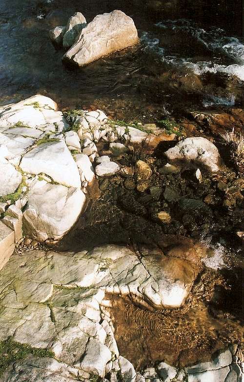
hgrapid - Apr 12, 2007 12:54 pm - Hasn't voted
TopographicThe topographic coordinates for this route show Arizona!
Bob Sihler - Apr 12, 2007 7:38 pm - Hasn't voted
Re: TopographicWhat, you didn't know this place was really near Yuma? Anyway, thanks for spotting it; I fixed that. It seems SP has some default coordinates set; I actually started a forum thread on this yesterday. I didn't make coordinates for the route since it was just a branch of its parent page, but I didn't realize the other ones got posted!