
|
|
Route |
|---|---|
|
|
39.34560°N / 106.2536°W |
|
|
Hiking, Mountaineering, Scrambling |
|
|
Spring, Summer, Fall, Winter |
|
|
One to two days |
|
|
Class 2 or easy snow |
|
|
Overview
This is probably the most popular route to the peak because of its proximity to the Sangree M. Froelicher Hut. From the Buckeye Gulch Trailhead, the marked route climbs 3.5 miles to the Sangree M. Froelicher Hut. From the hut the route climbs up to the saddle between two minor peaks before following the ridge north to the summit (with several variations available). In winter, this is a reasonable route, but there is one slope where caution is advisable since it is a potential avalanche slope (which probably can be avoided with careful route finding).This route is about 10 miles round trip with about 2900 feet elevation gain. This route can be completed reasonably in one day year round (in winter it can be a long day), but staying at the Sangree M. Froelicher Hut is also enjoyable.
Note: I have only done this route in late November, so the route description may vary in summer.
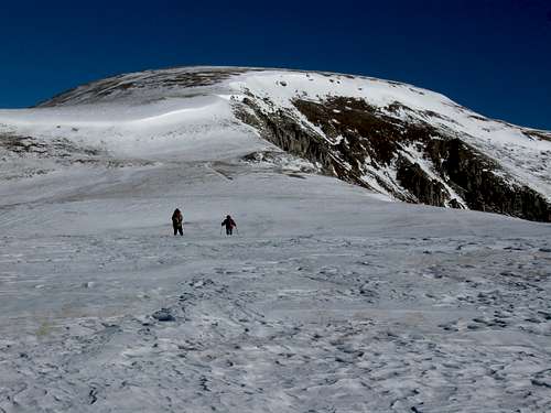 Ryan and Jeff approaching the summit of Buckeye Peak.
Getting There
The trailhead is north of Leadville and along Highway 91. To get to the trailhead from Leadville, from the junction of Highways 24 and 91, drive north along Highway 91 for 4.5 miles to the trailhead on the left (west) side of the road. The parking lot is marked for the 10th Mountain Division.If coming from the north, rather than driving all the way to Leadville, drive Highway 91 south of Climax and Fremont Pass to the turnoff which is located half way between mile markers 4 and 5.
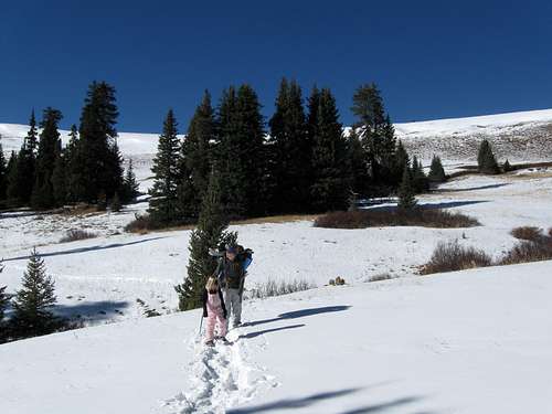 This is Shaylee and Kimberly on part of the approach to Buckeye Peak on November 26 2009.
Route Description
After a short distance up West Fork Buckeye Gulch, the trail leaves the 4wd road near a mine and heads up into the woods on the south side of the canyon.The trail eventually heads up a minor spur between two drainages and switchbacks a few times before circling the huge gentle bowl at the head of West Fork Buckeye Gulch. Keep your eye out for trail markers and the trail will head ENE contouring the slopes of Peaks 12156 and 12254 before reaching the Sangree M. Froelicher Hut. This is 3.5 miles from the trailhead.
From the hut, which is right below timberline, head northwest up the slopes (there are trail markers along the way) to the broad saddle between Peaks 12156 and 12254. From here, the route must be analyzed carefully. Observe the following photograph carefully:
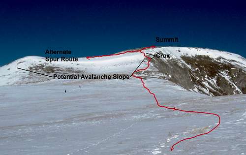 This is a detail of the South Ridge of Buckeye Peak.
Perhaps the easiest route is to head northeast to the South Ridge and follow it to the summit. The route close to the ridge has some rock scrambling and one very short steep snow slope (labeled the crux of the route and between elevations 12,400 and 12,600 feet elevation). It is possible that under the wrong conditions the short section could slide, but most of the time it is a reasonable winter route. If the short section of the route is not in condition, you can try an alternate route on the spur, but it too can have a potential avalanche slope if you aren't careful and don't drop low enough. Either way, choose the best route carefully.
Once above the crux section and avalanche slope, you are home free and it’s an easy climb north along the ridge to the flat summit. Unless you have a car shuttle to descend a different route, return the same way.
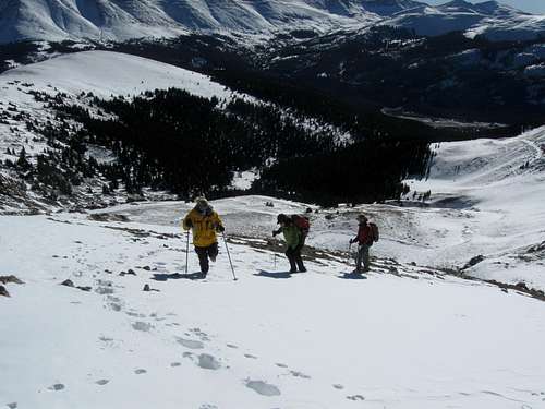 High on the South Ridge of Buckeye Peak.
Essential Gear
In the winter months, bring snowshoes or skis, ice axe, ski poles and proper winter clothing. Descending the upper slopes of Buckeye Peak on November 27 2009.