


-
 2358 Hits
-
 78.27% Score
-
 9 Votes
|
|
Route |
|---|---|
|
|
45.68066°N / 6.88416°E |
|
|
Mixed |
|
|
Spring |
|
|
Half a day |
|
|
Various according to the steepness of the slopes (by snowshoes) |
|
|
Note
|
La montagna chiama i suoi figli, ed essi rispondono fedelmente al suo appello… Osvaldo Cardellina, Diario alpinistico, 1964-65 Page texts: @ OsvaldoCardellina "Osva", passed away on May 2, 2022. Page owners: Christian Cardellina e Osvaldo Cardellina. Any updates from September 12, 2022: Antonio Giani, page administrator, friend and climbing companion. Testi della pagina: @ OsvaldoCardellina "Osva", scomparso il 2 maggio 2022. Proprietari pagina: Christian Cardellina e Osvaldo Cardellina. Eventuali aggiornamenti dal 12 settembre 2022: Antonio Giani, amministratore della pagina, amico e compagno di salite. |
Overview Partition
This page examines the three valleys more to the west of the South Slope with respect to the Central Valley: Rhêmes, Valgrisa and La Thuile; the latter with its extreme appendix which consists in the Walloon of the Little St. Bernard. All three possess the feature off, with parallel path, from the French border to the North flowing in Baltea. For the first two, being positioned along the axis of the South/North, generally the paths relate to the Eastern and Western sides of the same; for the third or La Thuile Valley the conformation in the manner of leaf exposures allows a little in all directions, while the valley aforesaid these change again, but reversed, in the North/South also for the relative paths. For these reasons the same geographic, unlike the Valleys of Cogne, Champorcher and Valsavarenche thanks to its vast Plateau Nivolé not offer great opportunities towards the snowshoes; in fact, the paths are, in the "high" that is in the heads of the valleys, very long and somewhat exposed to the fall of snowslides, or worse, avalanches; therefore require experience and excellent knowledge of the area. Surely they are more suitable for ski-mountaineering. The "low", ie at the beginning of the valleys themselves, on the other hand she does not present great opportunities, for which reason it is definitely the best choice, especially for newbies, contact itineraries partial or reduced to the "Minimum Route" certainly safer even if less gratifying. In any case, all three are worth a visit in late winter or spring in the valleys as they offer glimpses rather interesting and not without charm. Very often these paths are to be cataloged as mixed, as they require a continuous alternation between the put and take off the snowshoes; This is due to the fact that the snow is too low or on the ground that the cross slope is quite steep. You have to have Patience, always keeping in mind the small tips given here and the ability to know give up in the event of dangerous situations due to the state of the snow or, more simply, in particularly adverse weather conditions.
![]()
![]()
IMPORTANT NOTE: this work has been split at a later time, in order to make easier the consultation and reading. In practice, the area is divided on the Gran Paradiso National Park in the strict sense (Cogne and Valsavarenche Valleys), adding the Champorcher Valley which is outside of that, and excluding the Eastern slope of the Rhêmes that instead belongs still at it. So were separated by the valleys of the Graian Alps Southeast from the more Western to La Thuile Valley preceding the Chain of Mount Blanc; the areas most "internal" (Seventy-seven Streets in Central Valleys by Snow Shoes/2) and addressed to the Valley of Baltea have been treated in another page in its own right. So we will see the opportunity to hike through this ancient and at the same time the "new tool" currently back in fashion thanks to a new technology that no longer relies on wood and rope, but on plastics and metals; this allows a great progression with almost all types of snow, thanks to a better "floating".
Questa pagina esamina le tre valli più ad Occidente del Versante Meridionale rispetto alla Valle Centrale: Rhêmes, Valgrisa e La Thuile; questa ultima con la sua appendice estrema che consiste nel Vallone del Piccolo San Bernardo. Tutte e tre possiedono la caratteristica di scendere, con percorso parallelo, dai confini con la Francia sfociando a Settentrione nella Dora Baltea. Per le prime due, essendo posizionate lungo lo asse Sud/Nord, in genere i percorsi riguardano i lati Orientale ed Occidentale delle medesime; per la terza o Valle di La Thuile la conformazione a guisa di foglia consente esposizioni un poco in tutte le direzioni, mentre per il vallone suddetto queste cambiano nuovamente, ma rovesciate, in Nord/Sud anche per i relativi percorsi. Proprio per questi motivi geografici le stesse, a differenza delle Valli di Champorcher e Cogne nonché Valsavarenche grazie al suo vasto altipiano del Nivolé, non offrono grandi opportunità nei confronti delle racchette da neve; infatti i percorsi sono, nella parte "alta" cioé nelle testate delle valli, molto lunghi ed alquanto esposti alla caduta di slavine o, peggio, valanghe; perciò richiedono esperienza ed ottima conoscenza del territorio. Sicuramente sono più indicati per lo sci-alpinismo. La parte "bassa", ovvero all'inizio delle medesime, per contro anche lei non presenta grandi opportunità, per la qual cosa risulta scelta sicuramente migliore, soprattutto per i neofiti, rivolgersi ad itinerari più parziali o ridotti alle "Minimum Route", certamente più sicure anche se meno gratificanti. In ogni caso meritano tutte e tre una visita nel tardo inverno oppure in primavera poichè le vallate offrono scorci alquanto interessanti e non privi di suggestioni. Molto spesso questi percorsi son da catalogare come misti, poiché richiedono un alternanza continua tra il mettere e togliere le racchette da neve; questo é dovuto al fatto che o la neve é troppo bassa oppure per il motivo che l'attraversamento dei pendii risulta alquanto ripido. Bisogna ostentar Pazienza, sempre tenendo bene a mente i piccoli consigli qui riportati e la capacità di sapere rinunciare in caso di situazioni di pericolosità dovuto allo stato dell'innevamento o, più semplicemente, a condizioni metereologiche particolarmente avverse.
NOTA IMPORTANTE: questo lavoro é stato sdoppiato in un successivo momento, onde renderne più agevoli la consultazione e la lettura. In pratica s'é divisa l'area concernente il Parco Nazionale del Gran Paradiso in senso stretto (Valli di Cogne, Valsavarenche), aggiungendovi la Valle di Champorcher che risulta al di fuori del medesimo ed escludendo il versante Orientale di quella di Rhêmes invece appartenente ancora a questo. Quindi son state separate le valli delle Alpi Graie del Sudest da quelle più Occidentali insino alla Valle di La Thuile precedente la Catena del Monte Bianco; le zone maggiormente "interne" (Settantasette Vie nella Valle Centrale tramite Racchette da Neve/2) e rivolte alla Valle della Dora Baltea sono state trattate in altra pagina a se stante. Quindi vedremo le possibilità d'effettuar escursioni tramite questo antico e nello stesso tempo "nuovo attrezzo" ritornato attualmente di moda grazie ad una nuova tecnologia basantesi non più sul legno e la corda, bensì sulla plastica ed i metalli; questa consente un'ottima progressione con quasi tutte le tipologie di neve, grazie ad un miglior "galleggiamento".
![]()
NOTA IMPORTANTE: questo lavoro é stato sdoppiato in un successivo momento, onde renderne più agevoli la consultazione e la lettura. In pratica s'é divisa l'area concernente il Parco Nazionale del Gran Paradiso in senso stretto (Valli di Cogne, Valsavarenche), aggiungendovi la Valle di Champorcher che risulta al di fuori del medesimo ed escludendo il versante Orientale di quella di Rhêmes invece appartenente ancora a questo. Quindi son state separate le valli delle Alpi Graie del Sudest da quelle più Occidentali insino alla Valle di La Thuile precedente la Catena del Monte Bianco; le zone maggiormente "interne" (Settantasette Vie nella Valle Centrale tramite Racchette da Neve/2) e rivolte alla Valle della Dora Baltea sono state trattate in altra pagina a se stante. Quindi vedremo le possibilità d'effettuar escursioni tramite questo antico e nello stesso tempo "nuovo attrezzo" ritornato attualmente di moda grazie ad una nuova tecnologia basantesi non più sul legno e la corda, bensì sulla plastica ed i metalli; questa consente un'ottima progressione con quasi tutte le tipologie di neve, grazie ad un miglior "galleggiamento".

Getting There
BY CAR:
BY PLANE:
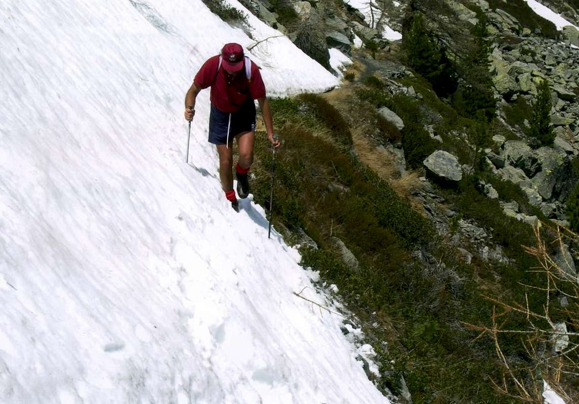
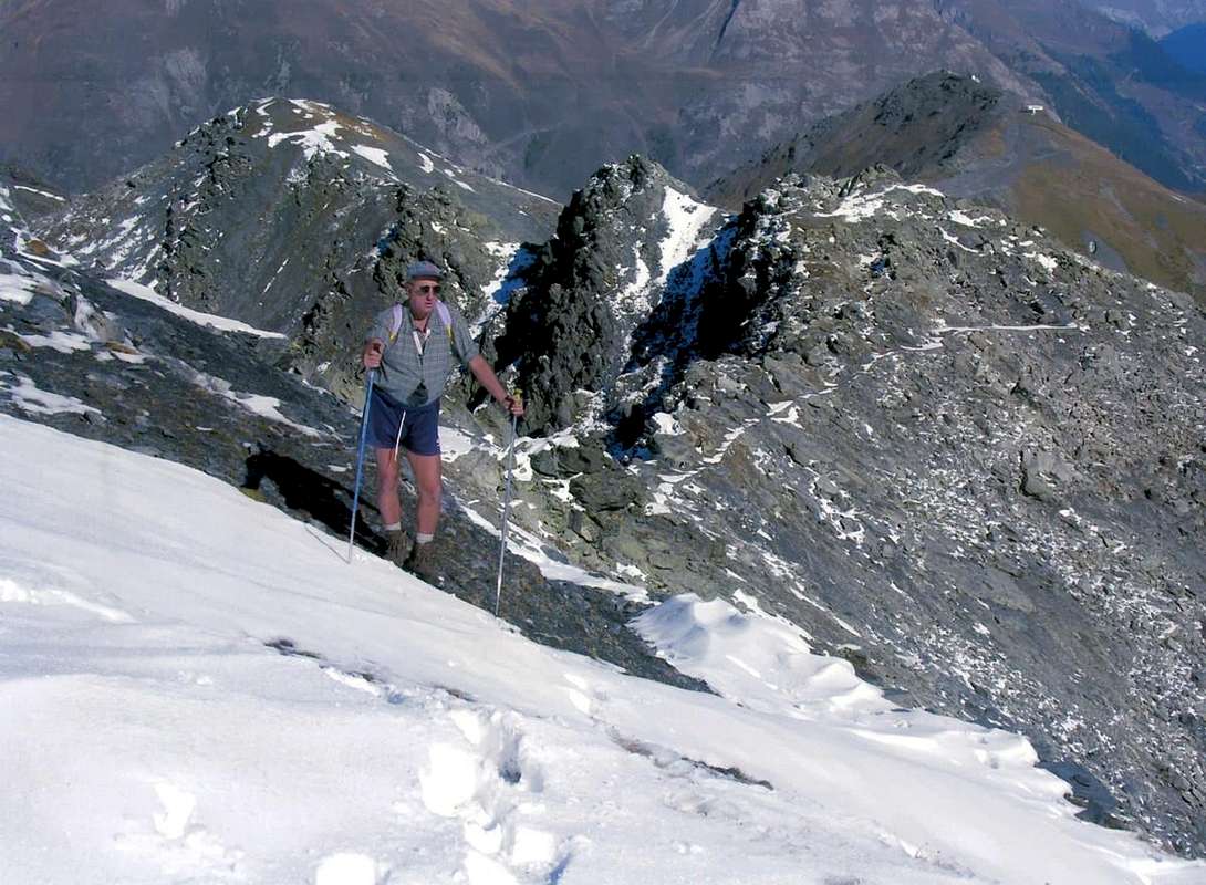
"Sometimes it is tiring already come this far ... / A volte l'é dura già giunger fin qui ...", by Mathias Zehring
![]()
- From TORINO, MILANO, etc: Motorway A5. Exit at AOSTA West (Aymaville) or Morgex Municipalities.
- From IVREA Town to Villeneuve, Arvier, Pré Saint Didier Municipalities.
- From Villeneuve to Rhêmes Valley
- From Villeneuve (670m) to Rhêmes Valley: Introd (880m), Rhêmes Saint Georges (1.171m), Notre Dame (1.725m) Communes, through Regional Main Road, up to the Thumel Village (1.887m) with Municipal Road and to Gian Federico Benevolo Refuge (2.280m), through dirt farms road or underlying path.
- From Liverogne (Arvier) to Valgrisenche
- From Arvier to Liverogne Fraction (730m) and from this to Valgrisenche Valley, up to the Valgrisenche Municupality (1.664m) and Mondanges, Surier, Us(s)eliéres Villages around the artificial Beauregard Dam, through Regional Road. Mario Bezzi at Vaudet and Chalet de l'Epée Refuges through paths.
- From Pré Saint Didier to La Thuile & Little Saint Bernard Valleys
- From Pré Saint Didier (1.010m), with State Road, to La Thuile Valley: Elévaz, Balme Villages, La Thuile Commune, 1.441m; from this to Little Saint Bernard Vallon towards the Little Saint Bernard Hill (2.188m), through State Road. To Albert Deffeyes Refuge with muletrack from La Joux Fraction.
- From FRANCE: through the Mont Blanc Tunnel to Entrèves-crossroads to Vény/Ferret Valleys - Mountain Guides of Courmayeur - La Saxe Rock Gym - Courmayeur. By Little Saint Bernard Pass, closed since November until half May to La Thuile Valley - Pré Saint Didier - Courmayeur. It is not necessary to take Motorway A5: you can drive on SR.26, in the direction of AOSTA - IVREA - TURIN.
BY PLANE:
- Aeroporto "Corrado Gex" Saint Christophe (Aosta).
Rhêmes (Benevolo Refuge Zone )
Even this valley, with its hiking Basei Bousson, Galisia, Basagne, Fond, Calabre and Tsatelèina, is full of proposals aimed at downhill skiing, while snowshoeing trails are limited to areas further reduced. In any case, both towards the ski to "our" gear wheel activity exclusively in the vicinity of Refuge Mario Bezzi, just above the Alp Lavassey. If the first practice is the starting point for the second surely is the point of arrival, except for a few "impromptu" trip to the distant Hills of Basei and Bassac Déré and realative Peaks Basei, Beak of Great Traversière or to the Tsantelèina Pass; but these are intended climbs to a few people, well trained, and, in any case, to be made at the end of spring or in early summer. In these cases the transformation agrees also long stretches without tool or often using part of the same, as surely in the end of Basei where steep rocks (equipped ) preclude their use. Also true that, sometimes, there is more success to find snow in August Holiday that in the beginning of the season, but these are exceptional situations demonstrating the unpredictability of the mountain. More semplecemente to look like the best routes are close to those of Thumel Village, starting point, or in the vicinity of the refuge, complicated enough point. The climb Notre Dame to the Entrelor Hill is rather more complex than the side Valsavarenche and certainly the most suitable ski-mountaineering. However interesting are the milestones at the shelter, they constitute trips workout in the beginning of the season. All other parts aimed at the low end may offer short trips of initiation, while between St. Georges and Notre Dame you can practice ice climbing.
Rhêmes, adjacent to Valdisère (France), Valsavarenche and Valgrisenche.
It reaches from Villeneuve (670m) towards Introd (880m), Rhêmes-Saint Georges (1.234m), Rhêmes-Notre Dame (1.723m) Communes to Thumel old Village (1.879m).
From Thumel Village to Basei Pass
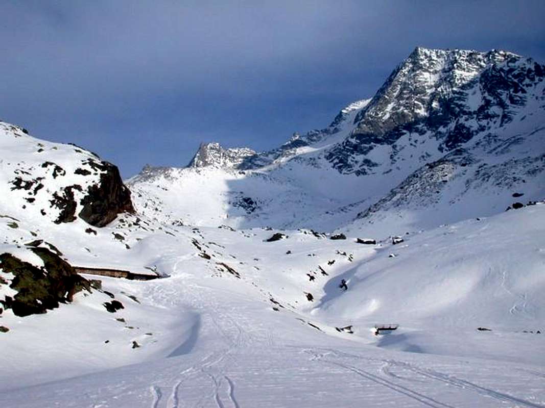
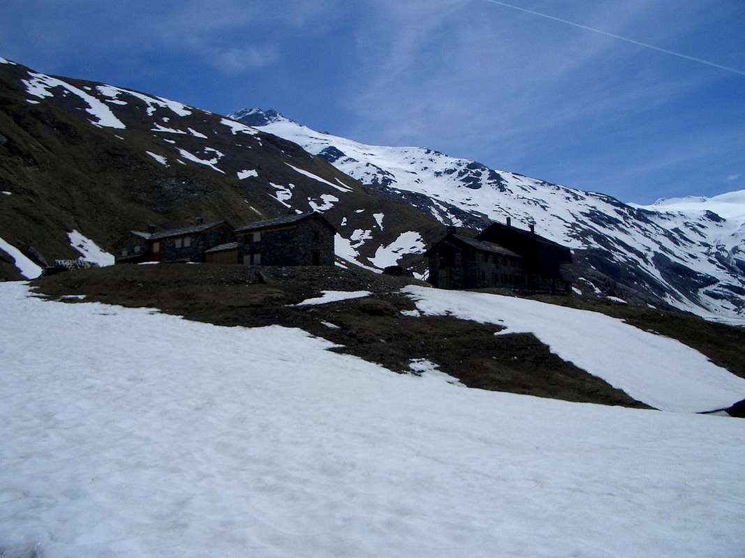
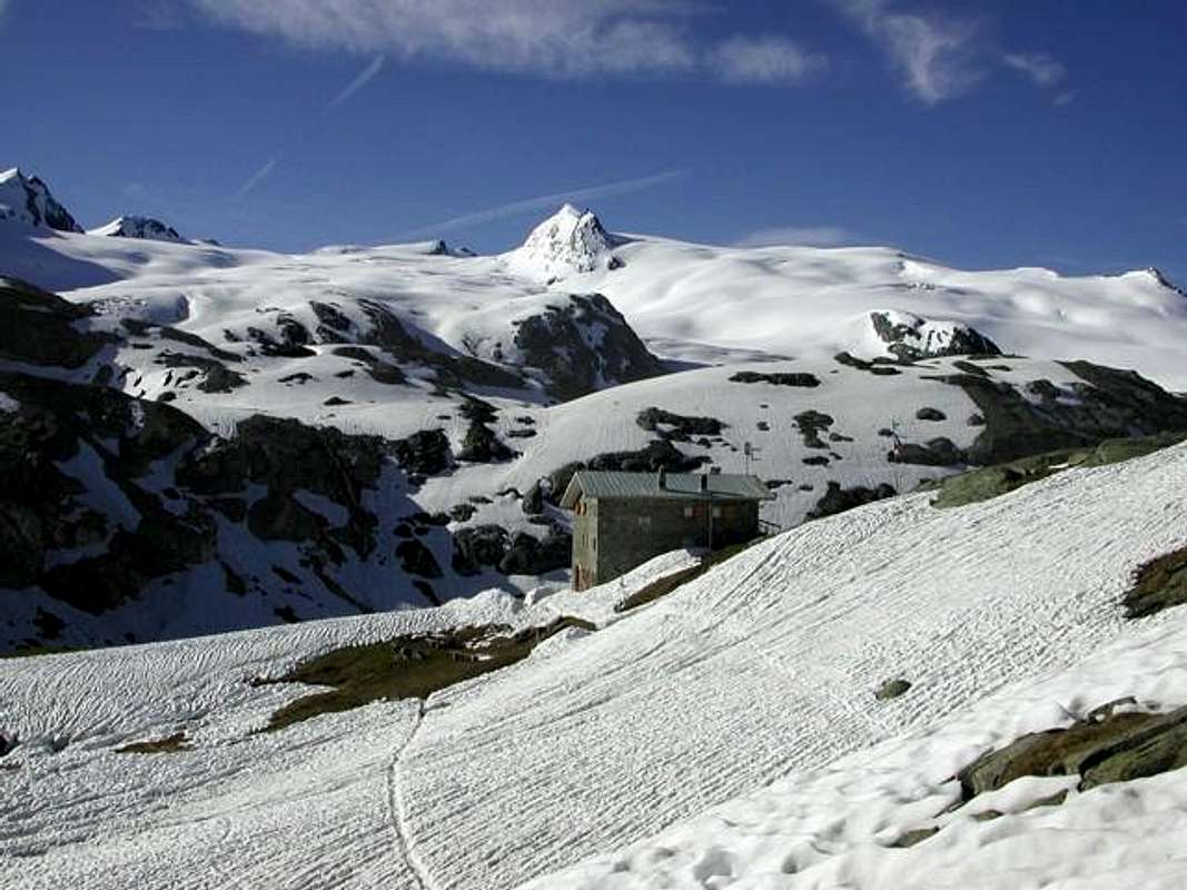
1) - Basic Itinerary n° 1: from Villeneuve Municipality to alternative Valsavarenche/Rhêmes Valleys with Regional Road; from fork towards Introd, Brenloz/Tache Hamlets, Rhêmes-Saint Georges Commune, Proussaz (1.445m; Holiday Farms"Le Baton 'Or" and "Le Vieux Creton" nearby Creton (1.447m, 1.548m) and"Edelweiss" (1.600m), below Melignon, Artalle (1.654m), Carré (1.664m) Villages to Main tourist center Rhêmes-Notre Dame (1.723m). Continue on asphalt road towards Bruil (1.723m), Moulin de Chaudanne/Pellaud (+; 1.811m) Villages to Thumel Villages neighbor the torrent into a grassy plaine (1.879m; great dirt parking immediately before the same in altitude 1.848m; signal no passage). From this, before with dirt farms road to winding road 1.901 meters (various signals, panels), after through path in South and towards Saint Pantaléon (2.010m; + chapel; *** fork paths to Grand Vaudala(z) Vallon) and immediately after a winding road North/South to following Barmaverain Pasture (2.037m). Continue through false level route with a long diagonal in South below the waterfalls (2.051m) and subsequent (2.087m); crossing Roman Bridge, by dirt road also with a shortcut of path to Benevolo Refuge (2.280m), above Lavassey Pasture (2.227m; (F+; 3h'30/4h'15).
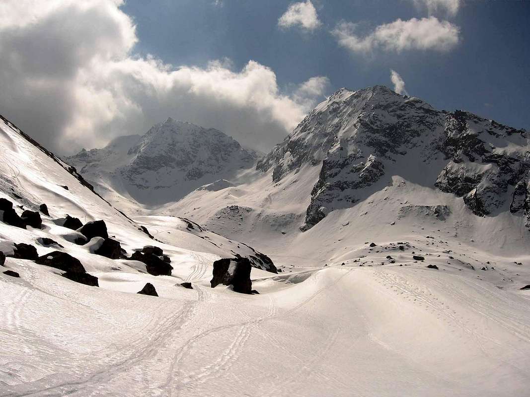
2) - Exceptional Via n° 1: from Refuge go before South and, crossing two stony small bridges on Rhêmes Doire, after change twice Northwest/South passing Sauches Alp (2.313m) and following fork (2.420m; in South path to Granta Parei/Tsantàleina Lakes); from cross instead tourning Northwest to overhanging rocky pomontory (2.615m; in South Normal Route to Granta Parei). Abandoning this last, continue on small path in Southwest reaching the effluent of Goletta Loch (2.698m). Doubling North the same e with route always Southwest, climb amongst moraines below South Face of Pointe Bassac Déré (keep a suitable distance due to the danger of falling rocks); reaching a zone more steep to cross towards a small trace into a serie of blocks and boulders rotten and broken. The subsequent slope should be carried out zigzagging between them (source hidden into rocks) and with a short traverse to the left to reach a small plateau, usually snowy. To cross with diagonal ascent on Southern border up to the final part under the pass; through an easy track to Bassac Déré Hill (3.082m); continue South on watershed Rhêmes/Valgrisenche and, through traces on North Ridge, after two Quotas (3.191m, 3.158m) to Becca of Traversière (3.337/8m) (D-; 4h'30/5h'15).
3) - Minimum Route n° 1: from Rhêmes Notre Dame (1.723m) with Municipal Road in South to winding road 1.901 meters (stony fountain) neighbor Thumel; from this to Barmaverain-Saint Pantaléon (2.010m, 2.037m) Alps through dirt road in West (better) also path more in East and above Rhêmes Doire (T; 1h'30/1h '45; 2h'00 on dirt road).
4) - Intermediate step n° 1: from Thumel, with three previous routes, to a first series of Waterfalls (2.051m; E; 1h'45/2h'15. Note: from Alp avalanches danger; requesting the snow is transformed), just after Barmaverain Pasture.
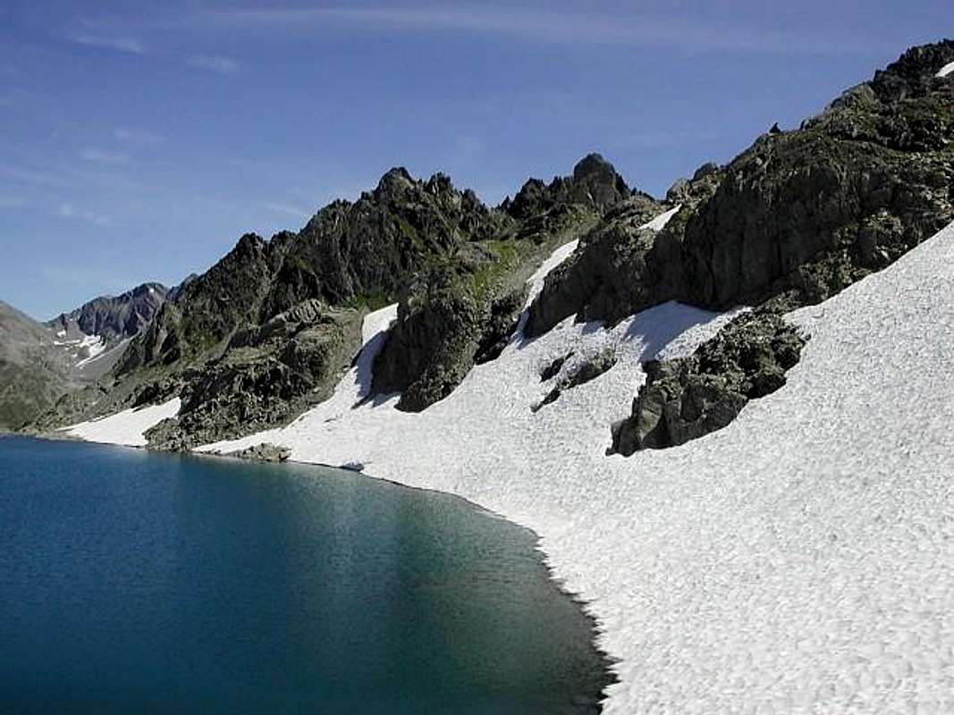
5) - Intermediate step n° 2: from shelter through path to rocky promontory 2.615 meters and following Goletta Lake (2.699m), under Glacier and North Face of Granta Parei (3.387m; F+; 2h'45/3h'15; same preceding remarks).
"From Tsantelèina above the Pass", by Marco Cossard "Crevassino"
![]()
^^^^^^^
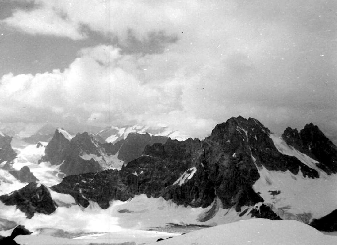
6) - Exceptional Via n° 2 (Granta Parei Tour): from refuge to fork 2.420m; continue South reaching before the small Granta Parei Lake (2.576m). Crossing the effluent and doubling West Truc de Tsantelèina (2.640m) to rocky promontory 2.706 meters before with path, after through a small trace less and less evident amongst the boulders; climbing on debris reach the point 2.706 meters just above Tsantelèina Loch (2.699m), below the vertical East Wall of Granta Parei. Passing over Western shore, through blocks and moraines, to reach the Tsantelèina and Sauches Glaciers. With delicate traverse on the same and bending more Southwest to Tsantelèina Pass (3.154m), between Pic Goletta/Tsantelèina Summits (M+; 4h'15/4h'45). Descent: before in Northwest on Rhêmes-Golette Glacier, after in North crossing completely the Northern Golette Glaciers bending Northeast below Granta Parei West and North Faces and above Goletta Lake; reached the Standard Route of the same to the base of the Northeast Ridge, with preceding routes through traces-path, to Benevolo (see the two next B&W pictures; F; 3h'00/3h'15 from pass to refuge.
*** Special footnote: all the aforesaid crossing glaciers requires extreme caution, especially so for those to be carried down; this tour is not open to all and requires experience and knowledge of glaciers to a certain level; also sometimes, it is not practicable due to the state of the glaciers; in this situation is preferable return with same via.
"From Tsantelèina Pass to Goletta Lake Route", by Marco Cossard "Crevassino"
![]()
^^^^^^^
7) - Intermediate step n° 3: from shelter to point 2.756 meters just over the Northeastern emissary of Goletta Lake; from this to Bassac Déré Pass (3.082m), between Becca of Traversière/Bassac Déré (3.353m) Summits (M+; 4h'00/4h'30. Remark: this path can be considered a variant of the previous shortened route; typically is the busiest via).
8) - Variant n° 1: from Thumel, leaving South the path to Shelter, crossing small wooden bridge on Dora Rhêmes (splendid canyon) and through a subsequent footbridge, through small path neighbor a series of waterfalls, to overcome the first ramp into forest; after a very narrow gorge and getting closer and closer Vaudaletta Torrent reach an alternative (2.500m; in East to homonym walloon to Leynir Hill 3.084m, below Taou Blanc 3.438m) nearby Vaudaletta(z) Alp (2.443m) and under the Forest Rangers P.N.G.P. Cabin (private; 2.480m); F+; 3h'00/3h'15).
9) - Variant n° 2: from fork just before Saint Pantaléon Alps (about 2.005 meters), crossing twice on small bridges up Dora Rhêmes and Vaudala Torrent, through path zigzagging in Southeast on Vaudala Walloon to Grand Vaudala Alp (+; 2.338m) at the entrance upper part of walloon (in East-southeast path along the torrent and following walloon to Rosset Hill 3.023m, between Leynir 3.230m/Rosset 3.100m Summits; E; 2h'50/3h'10 from Thumel).
"In the final part is best to remove snowshoes", by emilius
![]()
^^^^^^^
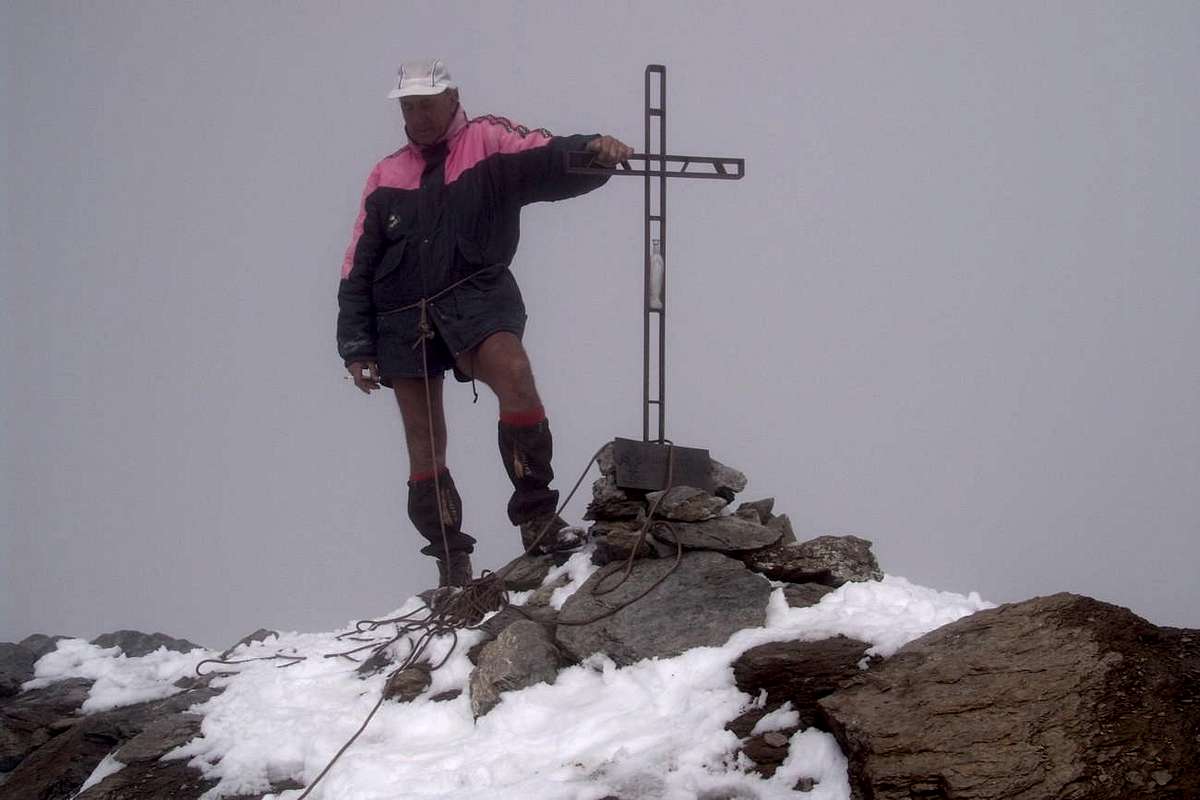
10) - Exceptional Via n° 3: from refuge through path in South-southeast and towards Basei Desot and Damon Pastures (2.309m, 2.412m), crossing various small walloons, to promontory 2.429 meters over the sources of Doire; bending more Southeast and crossing two secondaries torrent below Gran Croux (2.720m), with diagonal route amongst other height torrents and brooks reach the altitude 2.707 meters. From this, decisively East-southeast route above Northern flank of Lavassey Glacier, to fork around 3.020/30 meters under the two passes; in Northeast through path to 1) - Nivoletta(z) Pass (3130m). In Southeast through not always too obvious traces and very rotten blocks to 2) - Basei Hill (3.176m); from this through North Crest (better to remove snowshoes), crossing the Quota 3.196 meters, to terminal part. Doubling left (Est) and overcoming a small wall (exposed and equipped passage) towards final part of ridge to Basei (+ great Cross; 3.338m; D+; 4h'30/5h'15 from refuge; F; 8h'00/8h'15 from Thumel).
11) - Exceptional Via n° 4 and Variant n° 3: from Basei Pass to 1) -, with traverse on watershed Rhêmes/Nivolé Tableland, to Nivoletta Pass and neighbor Southern, Northern Summits (3.163m, 3.209m; M+; 1h'00/1h'15). Variant n° 3: also from fork around 3.020/30 meters through semicircular route Northeast/Southeast to pass and subsequent preceding route on enough easy South-southwest Crest. Possibility, good conditions, combine the pathways, but keep in mind that the hike is already very long for one of the two peaks: high degree of training required.
"But it does not always go so well ... / Ma non sempre va così bene ...", by Antonio
![]()
"As a self crucified alone ... / Come autocrocefiggersi da soli...", by emilius
![]()
"Here the Fatigue, beyond the Melody ... / Qui la Fatica, là la Melodia ...", by buxlex
![]()
It reaches from Villeneuve (670m) towards Introd (880m), Rhêmes-Saint Georges (1.234m), Rhêmes-Notre Dame (1.723m) Communes to Thumel old Village (1.879m).
From Thumel Village to Basei Pass
1) - Basic Itinerary n° 1: from Villeneuve Municipality to alternative Valsavarenche/Rhêmes Valleys with Regional Road; from fork towards Introd, Brenloz/Tache Hamlets, Rhêmes-Saint Georges Commune, Proussaz (1.445m; Holiday Farms"Le Baton 'Or" and "Le Vieux Creton" nearby Creton (1.447m, 1.548m) and"Edelweiss" (1.600m), below Melignon, Artalle (1.654m), Carré (1.664m) Villages to Main tourist center Rhêmes-Notre Dame (1.723m). Continue on asphalt road towards Bruil (1.723m), Moulin de Chaudanne/Pellaud (+; 1.811m) Villages to Thumel Villages neighbor the torrent into a grassy plaine (1.879m; great dirt parking immediately before the same in altitude 1.848m; signal no passage). From this, before with dirt farms road to winding road 1.901 meters (various signals, panels), after through path in South and towards Saint Pantaléon (2.010m; + chapel; *** fork paths to Grand Vaudala(z) Vallon) and immediately after a winding road North/South to following Barmaverain Pasture (2.037m). Continue through false level route with a long diagonal in South below the waterfalls (2.051m) and subsequent (2.087m); crossing Roman Bridge, by dirt road also with a shortcut of path to Benevolo Refuge (2.280m), above Lavassey Pasture (2.227m; (F+; 3h'30/4h'15).
2) - Exceptional Via n° 1: from Refuge go before South and, crossing two stony small bridges on Rhêmes Doire, after change twice Northwest/South passing Sauches Alp (2.313m) and following fork (2.420m; in South path to Granta Parei/Tsantàleina Lakes); from cross instead tourning Northwest to overhanging rocky pomontory (2.615m; in South Normal Route to Granta Parei). Abandoning this last, continue on small path in Southwest reaching the effluent of Goletta Loch (2.698m). Doubling North the same e with route always Southwest, climb amongst moraines below South Face of Pointe Bassac Déré (keep a suitable distance due to the danger of falling rocks); reaching a zone more steep to cross towards a small trace into a serie of blocks and boulders rotten and broken. The subsequent slope should be carried out zigzagging between them (source hidden into rocks) and with a short traverse to the left to reach a small plateau, usually snowy. To cross with diagonal ascent on Southern border up to the final part under the pass; through an easy track to Bassac Déré Hill (3.082m); continue South on watershed Rhêmes/Valgrisenche and, through traces on North Ridge, after two Quotas (3.191m, 3.158m) to Becca of Traversière (3.337/8m) (D-; 4h'30/5h'15).
3) - Minimum Route n° 1: from Rhêmes Notre Dame (1.723m) with Municipal Road in South to winding road 1.901 meters (stony fountain) neighbor Thumel; from this to Barmaverain-Saint Pantaléon (2.010m, 2.037m) Alps through dirt road in West (better) also path more in East and above Rhêmes Doire (T; 1h'30/1h '45; 2h'00 on dirt road).
4) - Intermediate step n° 1: from Thumel, with three previous routes, to a first series of Waterfalls (2.051m; E; 1h'45/2h'15. Note: from Alp avalanches danger; requesting the snow is transformed), just after Barmaverain Pasture.
5) - Intermediate step n° 2: from shelter through path to rocky promontory 2.615 meters and following Goletta Lake (2.699m), under Glacier and North Face of Granta Parei (3.387m; F+; 2h'45/3h'15; same preceding remarks).
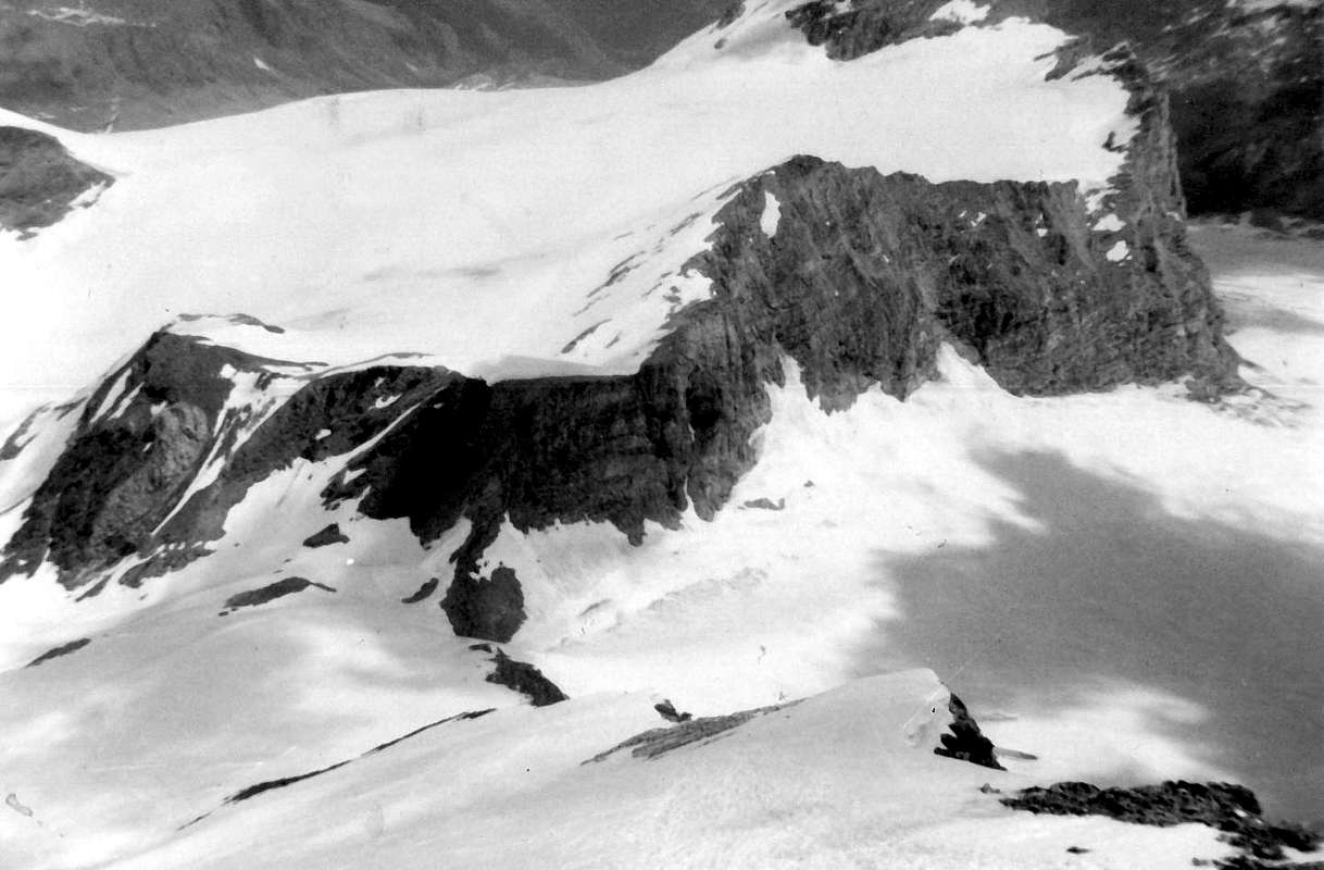
6) - Exceptional Via n° 2 (Granta Parei Tour): from refuge to fork 2.420m; continue South reaching before the small Granta Parei Lake (2.576m). Crossing the effluent and doubling West Truc de Tsantelèina (2.640m) to rocky promontory 2.706 meters before with path, after through a small trace less and less evident amongst the boulders; climbing on debris reach the point 2.706 meters just above Tsantelèina Loch (2.699m), below the vertical East Wall of Granta Parei. Passing over Western shore, through blocks and moraines, to reach the Tsantelèina and Sauches Glaciers. With delicate traverse on the same and bending more Southwest to Tsantelèina Pass (3.154m), between Pic Goletta/Tsantelèina Summits (M+; 4h'15/4h'45). Descent: before in Northwest on Rhêmes-Golette Glacier, after in North crossing completely the Northern Golette Glaciers bending Northeast below Granta Parei West and North Faces and above Goletta Lake; reached the Standard Route of the same to the base of the Northeast Ridge, with preceding routes through traces-path, to Benevolo (see the two next B&W pictures; F; 3h'00/3h'15 from pass to refuge.
*** Special footnote: all the aforesaid crossing glaciers requires extreme caution, especially so for those to be carried down; this tour is not open to all and requires experience and knowledge of glaciers to a certain level; also sometimes, it is not practicable due to the state of the glaciers; in this situation is preferable return with same via.

7) - Intermediate step n° 3: from shelter to point 2.756 meters just over the Northeastern emissary of Goletta Lake; from this to Bassac Déré Pass (3.082m), between Becca of Traversière/Bassac Déré (3.353m) Summits (M+; 4h'00/4h'30. Remark: this path can be considered a variant of the previous shortened route; typically is the busiest via).
8) - Variant n° 1: from Thumel, leaving South the path to Shelter, crossing small wooden bridge on Dora Rhêmes (splendid canyon) and through a subsequent footbridge, through small path neighbor a series of waterfalls, to overcome the first ramp into forest; after a very narrow gorge and getting closer and closer Vaudaletta Torrent reach an alternative (2.500m; in East to homonym walloon to Leynir Hill 3.084m, below Taou Blanc 3.438m) nearby Vaudaletta(z) Alp (2.443m) and under the Forest Rangers P.N.G.P. Cabin (private; 2.480m); F+; 3h'00/3h'15).
9) - Variant n° 2: from fork just before Saint Pantaléon Alps (about 2.005 meters), crossing twice on small bridges up Dora Rhêmes and Vaudala Torrent, through path zigzagging in Southeast on Vaudala Walloon to Grand Vaudala Alp (+; 2.338m) at the entrance upper part of walloon (in East-southeast path along the torrent and following walloon to Rosset Hill 3.023m, between Leynir 3.230m/Rosset 3.100m Summits; E; 2h'50/3h'10 from Thumel).
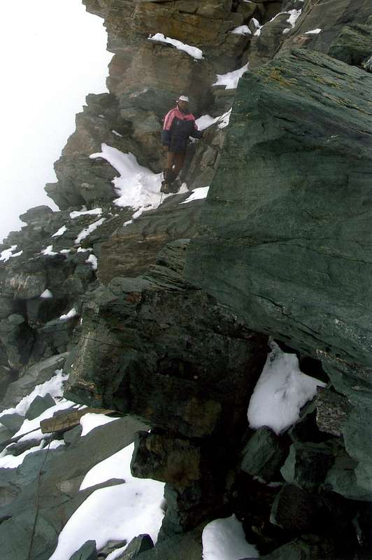
10) - Exceptional Via n° 3: from refuge through path in South-southeast and towards Basei Desot and Damon Pastures (2.309m, 2.412m), crossing various small walloons, to promontory 2.429 meters over the sources of Doire; bending more Southeast and crossing two secondaries torrent below Gran Croux (2.720m), with diagonal route amongst other height torrents and brooks reach the altitude 2.707 meters. From this, decisively East-southeast route above Northern flank of Lavassey Glacier, to fork around 3.020/30 meters under the two passes; in Northeast through path to 1) - Nivoletta(z) Pass (3130m). In Southeast through not always too obvious traces and very rotten blocks to 2) - Basei Hill (3.176m); from this through North Crest (better to remove snowshoes), crossing the Quota 3.196 meters, to terminal part. Doubling left (Est) and overcoming a small wall (exposed and equipped passage) towards final part of ridge to Basei (+ great Cross; 3.338m; D+; 4h'30/5h'15 from refuge; F; 8h'00/8h'15 from Thumel).
11) - Exceptional Via n° 4 and Variant n° 3: from Basei Pass to 1) -, with traverse on watershed Rhêmes/Nivolé Tableland, to Nivoletta Pass and neighbor Southern, Northern Summits (3.163m, 3.209m; M+; 1h'00/1h'15). Variant n° 3: also from fork around 3.020/30 meters through semicircular route Northeast/Southeast to pass and subsequent preceding route on enough easy South-southwest Crest. Possibility, good conditions, combine the pathways, but keep in mind that the hike is already very long for one of the two peaks: high degree of training required.

Anche questa valle, con le sue escursioni a Basei, Bousson, Galisia, Basagne, Fond, Calabre e Tsatelèina, é ricca di proposte rivolte allo sci-alpinismo, mentre i percorsi per le racchette da neve son limitati a spazi maggiormente ridotti. In ogni caso sia nei confronti dello sci che per il "nostro" attrezzo l'attività ruota esclusivamente nei dintorni del Rifugio Mario Bezzi, appena al di sopra dell'Alpe Lavassey. Se per la prima pratica lo stesso costituisce punto di partenza, per la seconda sicuramente é punto di arrivo, tranne qualche "estemporanea" escursione al lontani Colli di Basei e di Bassac Déré e realative Cime di Basei e Becca della Grande Traversière oppure al Colle della Tsantelèina; ma queste son ascensioni destinate a poche persone, bene allenate, e, in ogni caso, da effettuare al termine della primavera od in inizio di estate. In questi casi la trasformazione acconsente anche lunghi tratti senza l'attrezzo o spesso l'impiego parziale del medesimo, come sicuramente nella parte terminale della Basei dove rocce ripide (attrezzate) ne impediscono l'uso. Altresì vero che, a volte, ci é successo di trovare più neve a Ferragosto che in inizio di stagione, ma queste sono situazioni eccezionali a dimostrazione dell'imprevedibilità della montagna. Più semplecemente v'é da osservare come i percorsi migliori siano quelli di vicinanza a Thumel, punto di partenza, o nei dintorni del rifugio, già abbastanza complicato punto di arrivo. La salita da Notre Dame al Colle di Entrelor é invece più complessa rispetto al versante Valsavarenche e certamente indicata allo sci-alpinismo. Comunque interessanti sono le tappe intermedie al rifugio, tali da costituire gite di allenamento in inizio di stagione. Tutte le altre parti rivolte alla parte bassa possono offrire piccole gite di iniziazione, mentre tra St. Georges e Notre Dame si posson salir le cascate in ghiaccio.
Valgrisenche (Above Beauregard Dam & to Bezzi, Epée Huts)

Area queen of ski-mountaineering and, unfortunately, the heli skiing, Valgrisenche offers trips, like the previous one, which "rotate" to Bezzi Refuge. Apart from the long way to the Bivouac Ravelli, Lake of Saint Grat and Mont Hill (this is very dangerous for valanche), are the routes that surround the artificial Dam of Beauregard or climb to the Refuge Mario Bezzi or that of Refuge Chalet de l' Epee the most popular for snowshoeing. They become so interesting even shortest paths and milestones in the direction of the same proposals that may be nice to start the season. Similar situations can submit short trips above Planaval Hamlet targeting Villages Clousaz and Baulen overlying or, starting from the same visit to the beautiful Walloon of Fond up its lake, while achieving far Planaval Pass appears to be more prohibitive undertaking. Also in this case there are opportunities milestones, such as the Alp Glacier (2.162m) and the Barracks of Fond (2.310m) or the above Crosatie Pass (2.838m) and near Summit (2.933m); but in this last case, the trip itself is already long and demanding. Another small walk, not included in the panel, it can be carried out by the Village of Baulen (1.775m; small parking lot) to the North through the woods in the direction of Alp Milliery (1.656 m) to the homonym Hill (about 1.840 meters) and Mount Colombo (1.854m); with snowshoes expect some small passage complicated because of the impenetrable forest, which also forces the bypassing of some tree fell across the board.
Valgrisenche, adjacent to Valdisère (France), Rhêmes and La Thuile Valleys.
It reaches from Arvier (Liverogne) Municipality (776m, 740m) towards Main tourist center Valgrisenche below Beauregard Dam(1.661m), Bonne, Surrier to Us(s)elières Villages. Also to Planaval, Clusaz, Baulin Hamlets
From Bonne Village to Crosatie Pass
1) - Basic Itinerary n° 1: from Liverogne, with Regional Road, towards Valgrisenche (alternatives 1.661m, 1.788m), Bonne (1.788/1.810m), to Vieux Menthieu (1.848m; signal no passage) Villages, above Western shore of Beauregard Dam; abandoning South the road to Surrier/Usellières, continue West-southwest with dirt road and passing Bochal, Meillares (2.161m; direct path shortcut between the two) Pastures, through a wide and semicircular tour, to Arp Vieille Alp (2.220m; F; 2h'15/2h'30), under Mount Arp Vieille (2.963m)/Refuge of Angels (ex Clea Scavarda; 2.940m).
2) - Exceptional Via n° 1 and Variant n° 1: from Arp Vieille Pasture-shelter (path in North to Angels Refuge, ex Scavarda, burned down in 1990), through path before in West among grassy terrain to Captain Crova Shelter (2.405m; ruins) after through path in Northwest and, leaving South a secondary path to Mont Pelà (2.523m), continue to source in altitude 2.562m immediately below the pass. Climbing more in West and closely zigzagging switchbacks on the trail in terminal part reaching the Forclaz du Bré Pass (2.829m; ruins of Fiorio Shelter), between Southern Buttress of Testa del Rutor (3.486m)/Mont Arp Vieille. From this with few traces in South, through traces amongst great blocks on Northern Crest and crossing the Quota 2.950 meters, easily to Arp Vieille Summit (small military forts along the trail and of hunting right on Top with beautiful views on the azure St. Grat Loch; M+; 3h'00/3h'15 from Arp Vieille).
Variant n° 1: Possibility to continue the ridge watershed down to the Southeast Admissions Captain Ricci (2.751m, 2.688m) and from this small saddle at the junction 2.490 meters before reaching the dirt farm road near Arp Vieille.
"Unity is Strength", by Antonio
![]()
^^^^^^^
3) - Minimum Route n° 1: from Mondanges (1.652m), at the foot of dam, or from Bonne to Vieux Mentieu Villages (1.848m), with Main Road; from signal no passage at the beginning of dirt farms road to an alternative near the first winding road (path in North to Alpettaz Pasture 1.998m); instead continue in South-southwest and, after three hairpin bends (shortcut in parallel more to East) to Bochat Alp into a splendid larch-fir forest and with beautiful views in bottom on famous artificial Lake (about 1.900m; T; 1h'00/1h'15). Crossing possibility, pathless and through grassy, to neighbor Fètes Pasture more within the same forest, above the Arp Vieille Torrent (2.025m; 0h'15 more).
4) - Basic Itinerary n° 2 and Variant n° 1: from Mondanges, though Main Road with final short descent, to 1) - Surrier Villages (1.785m); from this, through path in Northwest to Grand'Alpe (1.988m; E/F+; 2h'00/2h'15).
Variant n° 1: or from Main Road near 2) Rognettaz Dèsott (about 1.975m; signal no transit), before the descent to Surrier, with dirt road to pasture. The both at the entrance of Saint Grat/Col du Mont Vallon (T/F; 1h'30/1h'45).
5) - Exceptional Via n° 2: from Grand'Alpe to Revèraz Desot Alpage (2.153m), through path in West to Col du Mont (2.639m; * much exposed to snowslides and avalanches in case of too high or unprocessed snow), between Western Archeboc (3.278m)-la Rocher Brune (2.720m)/Sachère Summits (3.209m; M; 3h'30/4h'00 from Grand'Alpe).
6) - Exceptional Via n° 3: from Grand'Alpe Pasture, reached through the preceding route, to Revèraz Desot Pasture (2.153m), with previous route; leaving left (West) the famous path to Col du Mont and tourning decisively North-northwest, to Saint Grat Loch (+; 2.462m), amongst Recoulaz Pass (2.867m) and Sachère also Gran Becca du Mont/Becca du Lac (3.405m)/Head of Rutor South Buttress/Mount Arp Vieille Summits (F; 3h'00/3h'15 from Gr. Alp).
7) - Minimum Route n° 2 and Basic Itinerary n° 3: from Surrier/Usellières Villages (1.785m, 1.790m), reached through a short descent on previous road, before through dirt road and after with small path in East-northeast to Arolla Pasture (1.921m; source); from this, before with path in East to 1) - Mont Fortchat Alpages (2.180m; source; E/F; 2h'40/3h'00) and subsequent crossing in Northeast. 2) - also, with more large tour on dirt farms road in Northeast/South from Arolla towards Nouva (2.135m; source) and following Mont Fortchat Pastures; from this to Epée Alps (2.345m) and just subsequent nrw Chalet de l'Epée Refuge (2.377m), into Southern side of homonym vallon and below Western (3.185m) and Eastern Mount Forciaz (3.244m)/Pointe Rabuigne (3.261m) (M-; 3h'30/4h'15).
"Infinite Space, Far Horizons ...", by buxlex
![]()
^^^^^^^
8) - Variant of Basic Itinerary n° 2: from Mont Fortchat Alp, through path in East above Mont Fortchat Torrent, to fork 2.397 meters; after with path-traces on lateral moraine of Fortchat/Invergnaou Glaciers to Ravelli Bivouac (2.860m; (M-; 3h'00/3h'15), below Western Face of Grande Rousse (3.607m, 3.577m) in homonym Western Basin.
9) - Basic Itinerary n° 3: from Surrier Village (1.785m; panels and signals), through dirt farms road path concomitant in South above main torrent, to Tsalé (1.931m) and Saxe Savoie Alpages (2.036m); from pasture, leaving West the deviation on dirt road to Saxe Ponton Alp (2.047m), continue through path along the Grisenche Doire reaching the point 2.172 meters just before Vaudet Alp (about 2.260 meters) and the following Mario Bezzi (2.284m; F+; 4h'00/4h'15), below Eastern Faces of Punta Plattes des Chamois (3.567m)/Becca de Suessa also de Schuetse (3.423m).
10) - Minimum Route n° 3: from Surrier , previous path, also from Usellières Villages passing through Arolla Pastures (1.921m) to the junction of two dirt roads in altitude about 1.850 meters; from this fork continue South, with path always along the torrent, to Salé (1.931m) and Saxe Savoie Alps (2.036m), near Grisenche Doire (E; 1h'45/2h'00).
"Everything escapes, but the Hutte is firm and solid ...", by Corvus
![]()
^^^^^^^
11) - Exceptional Via n° 4: from Regional Road, tourning briefly in West, to Planaval Hamlet (1.577/88m); continue North on Municipal Road to Clusaz Village (1.631m), immediately before Baule(i)n at the end of asphalt road (1.769m). From the first village, through path in West (an unique yellow signal in subsequent winding road), crossing a secondary torrent and towards Benevy Alp (1.950m; ruins), Alpage du Glacier (2.162m; path in North to Tignet Tower Pass 2.533m) to Fond Barracks (2.310m), below Fond Loch (2.439m). Reached the last and tourning North-northwdest through a small path (more steep in terminal part) to Crosatie Pass (2.838m) and, with easy, short Eastern Crest to nearby homonym Summit (2.838m; M+; 5h'00/5h'15), in West of Bec Taillà (2.983m), above Mollette Pass (2.774m).
"To Crosatie Pass & Summit", by Antonio
![]()
^^^^^^^
"The closer you get and the more you move away ... / Più t'avvicini, più s'allontana ...", by andrea.it
![]()
"Dejected, I'm going down ... / Demoralizzato, me ne torno giù ...", by emilius
![]()
"No longer hear the crackle of machine guns. Only Peace ... / Non si sente più il gracchiar di mitraglie. Sol Pace ...", by emilius
![]()
It reaches from Arvier (Liverogne) Municipality (776m, 740m) towards Main tourist center Valgrisenche below Beauregard Dam(1.661m), Bonne, Surrier to Us(s)elières Villages. Also to Planaval, Clusaz, Baulin Hamlets
From Bonne Village to Crosatie Pass
1) - Basic Itinerary n° 1: from Liverogne, with Regional Road, towards Valgrisenche (alternatives 1.661m, 1.788m), Bonne (1.788/1.810m), to Vieux Menthieu (1.848m; signal no passage) Villages, above Western shore of Beauregard Dam; abandoning South the road to Surrier/Usellières, continue West-southwest with dirt road and passing Bochal, Meillares (2.161m; direct path shortcut between the two) Pastures, through a wide and semicircular tour, to Arp Vieille Alp (2.220m; F; 2h'15/2h'30), under Mount Arp Vieille (2.963m)/Refuge of Angels (ex Clea Scavarda; 2.940m).
2) - Exceptional Via n° 1 and Variant n° 1: from Arp Vieille Pasture-shelter (path in North to Angels Refuge, ex Scavarda, burned down in 1990), through path before in West among grassy terrain to Captain Crova Shelter (2.405m; ruins) after through path in Northwest and, leaving South a secondary path to Mont Pelà (2.523m), continue to source in altitude 2.562m immediately below the pass. Climbing more in West and closely zigzagging switchbacks on the trail in terminal part reaching the Forclaz du Bré Pass (2.829m; ruins of Fiorio Shelter), between Southern Buttress of Testa del Rutor (3.486m)/Mont Arp Vieille. From this with few traces in South, through traces amongst great blocks on Northern Crest and crossing the Quota 2.950 meters, easily to Arp Vieille Summit (small military forts along the trail and of hunting right on Top with beautiful views on the azure St. Grat Loch; M+; 3h'00/3h'15 from Arp Vieille).
Variant n° 1: Possibility to continue the ridge watershed down to the Southeast Admissions Captain Ricci (2.751m, 2.688m) and from this small saddle at the junction 2.490 meters before reaching the dirt farm road near Arp Vieille.
3) - Minimum Route n° 1: from Mondanges (1.652m), at the foot of dam, or from Bonne to Vieux Mentieu Villages (1.848m), with Main Road; from signal no passage at the beginning of dirt farms road to an alternative near the first winding road (path in North to Alpettaz Pasture 1.998m); instead continue in South-southwest and, after three hairpin bends (shortcut in parallel more to East) to Bochat Alp into a splendid larch-fir forest and with beautiful views in bottom on famous artificial Lake (about 1.900m; T; 1h'00/1h'15). Crossing possibility, pathless and through grassy, to neighbor Fètes Pasture more within the same forest, above the Arp Vieille Torrent (2.025m; 0h'15 more).
4) - Basic Itinerary n° 2 and Variant n° 1: from Mondanges, though Main Road with final short descent, to 1) - Surrier Villages (1.785m); from this, through path in Northwest to Grand'Alpe (1.988m; E/F+; 2h'00/2h'15).
Variant n° 1: or from Main Road near 2) Rognettaz Dèsott (about 1.975m; signal no transit), before the descent to Surrier, with dirt road to pasture. The both at the entrance of Saint Grat/Col du Mont Vallon (T/F; 1h'30/1h'45).
5) - Exceptional Via n° 2: from Grand'Alpe to Revèraz Desot Alpage (2.153m), through path in West to Col du Mont (2.639m; * much exposed to snowslides and avalanches in case of too high or unprocessed snow), between Western Archeboc (3.278m)-la Rocher Brune (2.720m)/Sachère Summits (3.209m; M; 3h'30/4h'00 from Grand'Alpe).
6) - Exceptional Via n° 3: from Grand'Alpe Pasture, reached through the preceding route, to Revèraz Desot Pasture (2.153m), with previous route; leaving left (West) the famous path to Col du Mont and tourning decisively North-northwest, to Saint Grat Loch (+; 2.462m), amongst Recoulaz Pass (2.867m) and Sachère also Gran Becca du Mont/Becca du Lac (3.405m)/Head of Rutor South Buttress/Mount Arp Vieille Summits (F; 3h'00/3h'15 from Gr. Alp).
7) - Minimum Route n° 2 and Basic Itinerary n° 3: from Surrier/Usellières Villages (1.785m, 1.790m), reached through a short descent on previous road, before through dirt road and after with small path in East-northeast to Arolla Pasture (1.921m; source); from this, before with path in East to 1) - Mont Fortchat Alpages (2.180m; source; E/F; 2h'40/3h'00) and subsequent crossing in Northeast. 2) - also, with more large tour on dirt farms road in Northeast/South from Arolla towards Nouva (2.135m; source) and following Mont Fortchat Pastures; from this to Epée Alps (2.345m) and just subsequent nrw Chalet de l'Epée Refuge (2.377m), into Southern side of homonym vallon and below Western (3.185m) and Eastern Mount Forciaz (3.244m)/Pointe Rabuigne (3.261m) (M-; 3h'30/4h'15).
8) - Variant of Basic Itinerary n° 2: from Mont Fortchat Alp, through path in East above Mont Fortchat Torrent, to fork 2.397 meters; after with path-traces on lateral moraine of Fortchat/Invergnaou Glaciers to Ravelli Bivouac (2.860m; (M-; 3h'00/3h'15), below Western Face of Grande Rousse (3.607m, 3.577m) in homonym Western Basin.
9) - Basic Itinerary n° 3: from Surrier Village (1.785m; panels and signals), through dirt farms road path concomitant in South above main torrent, to Tsalé (1.931m) and Saxe Savoie Alpages (2.036m); from pasture, leaving West the deviation on dirt road to Saxe Ponton Alp (2.047m), continue through path along the Grisenche Doire reaching the point 2.172 meters just before Vaudet Alp (about 2.260 meters) and the following Mario Bezzi (2.284m; F+; 4h'00/4h'15), below Eastern Faces of Punta Plattes des Chamois (3.567m)/Becca de Suessa also de Schuetse (3.423m).
10) - Minimum Route n° 3: from Surrier , previous path, also from Usellières Villages passing through Arolla Pastures (1.921m) to the junction of two dirt roads in altitude about 1.850 meters; from this fork continue South, with path always along the torrent, to Salé (1.931m) and Saxe Savoie Alps (2.036m), near Grisenche Doire (E; 1h'45/2h'00).
11) - Exceptional Via n° 4: from Regional Road, tourning briefly in West, to Planaval Hamlet (1.577/88m); continue North on Municipal Road to Clusaz Village (1.631m), immediately before Baule(i)n at the end of asphalt road (1.769m). From the first village, through path in West (an unique yellow signal in subsequent winding road), crossing a secondary torrent and towards Benevy Alp (1.950m; ruins), Alpage du Glacier (2.162m; path in North to Tignet Tower Pass 2.533m) to Fond Barracks (2.310m), below Fond Loch (2.439m). Reached the last and tourning North-northwdest through a small path (more steep in terminal part) to Crosatie Pass (2.838m) and, with easy, short Eastern Crest to nearby homonym Summit (2.838m; M+; 5h'00/5h'15), in West of Bec Taillà (2.983m), above Mollette Pass (2.774m).
Area regina dello sci-alpinismo e, purtroppo, anche dello eli sci, la Valgrisenche offre gite, come quella precedente, che "ruotano" al Rifugio Bezzi. A prescindere dalle lunghe vie per il Bivacco Ravelli, Lago di San Grato e Col du Mont (questo molto pericoloso per le valanche), sono gli itinerari che circondano la Diga artificiale di Beauregard o la salita al Rifugio Mario Bezzi od a quello del Rifugio Chalet de l'Epée i più frequentati per le racchette da neve. Diventano così interessanti anche i percorsi minimi e le tappe intermedie in direzione dei medesimi che possono costituire simpatiche proposte di inizio stagione. Analoghe situazioni possono presentare brevi gite sopra Planaval rivolte ai Villaggi di Clousaz e Baulen soprastanti oppure, con partenza dai medesimi la bella visita al Vallone di Fond fino all'omonimo lago, mentre il raggiungimento del lontano Passo di Planaval appare come impresa più proibitiva. Anche in questo caso non mancano le possibilità di tappe intermedie, come ma in questo ultimo caso la gita diventa già lunga ed impegnativa. Un'altra piccola passeggiata, non inserita nel pannello, può essere effettuata dal Villaggio di Baulen (1.775 m; piccolo parcheggio) verso Settentrione attraverso il bosco in direzione dell'Alpe Milliery (1.656 m) del Colle (1.840 metri circa) e del Monte Colombo (1.854 m); con le racchette da neve attendersi qualche passaggetto complicato a causa della foresta intricata, tale da costringere anche ad alcuni piccoli scavalcamenti di qualche albero crollato trasversalmente.
La Thuile & Little Saint Bernard (Towards the fortifications of Valaisan & Deffeyes Shelter)
The analysis of this last great valley does not differ much from the previous ones. The Valley La Thuile can certainly be regarded as a queen among those orographic Southern about downhill skiing; In fact, a "domaine skiable" huge stretches over the Tourist Village Les Suches to connect also in La Rosière in Haute Tarentaise. With regard to the Eastern side, we recommend that the ascent to the Refuge Albert Deffeyes the beginning of the great glaciers that Rutor certainly not suited to this discipline. Then we go to "seek his fortune" on the opposite side, or in those great spaces that stretch from the Great Assaly (3.174m) towards the North-northwest in the direction of Valaisan and the Little Saint Bernard Hill; further and further to the North of the same long parallel walloons are directed towards Pointe Léchaud (3.127m) and Mount Berio Blanc (3.252m) but are very exposed to avalanches. We prefer to avoid sending them back, if anything, to hiking in summer. Instead, we "fall back" on the Vallons Bellecombe and Tachuy with their beautiful lakes and in the wild of Ponteilles from Les Suches door to the crest watershed Belvedere/Bella Valletta/Mount Valaisan. The small range of Fréduazs (2.938m) stands between these two areas just mentioned above. Many are the routes so-called "minimum" and some basic ones that lend themselves to multiple variants; the ascent to the Mount Valaisan can be considered as Exceptional Via, both the length (not excessive in relation to Bella Valletta) for problem situations that can be reserved at the end in case of snow. A trip in itself can be considered as a separate entrance to the valley of Mount Crammont (2.737m); it must be addressed in its Eastern Slopes along with snow absolutely beautifully transformed. Beyond, in the Val Veny, little or nothing for the closure of the winter road, which dates back from Courmayeur to the Notre Dame de la Guérison; the same may be considered a small path of initiation for snowshoeing.
La Thuile, adjacent to Valdisère/Haute Tarentaise (France), Veny Valley-La Lex Blanche Vallon, Arpy Basin and Valgrisenche.
It reaches from La Rosière (1.890m; France) by Little Saint Bernard Hill (2.202m). From Pré Saint Didier (1.017m) or Morgex (920m) Communes through San Carlo Hill (1.960m). From La Thuile Municipality (1.484m) to La Joux (1.603m) or to La Suche Resort (2.145 m); also to Village Main tourist center Little Saint Bernard Hill (2.185 m).
From La Suche de Cantamont Resort to Mont Crammont
1) - Basic Itinerary n° 1: from La Thuile, with State Road of Little Saint Bernard towards the alternatives 1.972 meters on Main Road (below Tête de Tsargian 2.708m) and 1.990 meters (to Combemar and "Fourclaz Express" ski lift) metres, where completely reversing direction with a long East straight to Les Suches de Cantamont Resort (2.145m; stone fountain near a small parking). From this, through dirt road in Southwest, passing under three ski lifts and abandoning North the little watershed Terre Noire (2.419m)/Chaz-Duraz (2.579m), to third fork 2.402 meters, neighbor the arrival of "Argillen Express". Continue on dirt, discarding left another, up to the following cross in Bedalla Tableland (2.465m; yellow signal); leaving Southwest the road to Fourclaz (2.486m), Mount Belvedere Hills (2.568m), through path decisively in South with short descent to subsequent walloon floor in Suche Tableland; tourning East through a diagonal ramp and doubling a rocky small spur enter into a following Ponteilles Walloon, in upper part. Changing direction completely again and the trail turns into a good military muletrack, reached a more steep section of debris-blocks (possibility snow presence) will gradually go below the ridge. Continuing to the South and crossing two altitudes (2.731m, 2.710m) reaches a grassy small shoulder (2.767m) and immediately after Bella Valletta Summit (2.811m) with small and occulted bunkers, above Ponteilles Vallon (M-; 3h'50/4h'10).
"Free spaces, no more cross-linked ...", by emilius
![]()
^^^^^^^
2) - Exceptional Via n° 1: from La Suche de Cantamont towards Bedalla Tableland to Bella Valletta through preceding route; from this, with easy, short descent, to following large Saddle (2.743m). Bending progressively West and, always through military muletrack just under the crest and crossing amongst various boulders, to terminal part on Eastern Slope. Here the trail becomes narrow and steep path and, passing near a bunker, with a short crossing to the South goes over a tiny rocky promontory; continue through a small rocky spur reaching the conclusive part. Generally, the route ends on the Southeast Ridge (signal output at the Top), which descends the Grand Glacier Pass (2.809m; alternative route through traverse from previous saddle and crossing on Mont Valaisan Glacier with numerous dangerous crevasses in Northern border) below Western Mont Fréduaz or Pointe de la Louie Blanche (2.932m). But in high snow presence (sometimes the rocks are covered with big sticks of ice) should bypass the small turret final with a delicate crossing on the Northern Slope and, finally, to Mont Valaisan (2.891m; D-; 5h'15/5h'30 Les Suches).
3) - Intermediate step with Variant n° 1 and n° 2: from La Suche-Cantamont, previous routes in Southwest, to:
Variant n° 1) - alternative 2.402 meters, below Grande Tête (2.379m); from fork, through dirt road in North and crossing under the two ski lifts "Chaz Duraz Express/Chaz Duraz" to upper alternative (2.527m; junction of three dirt roads). Finally, through diagonals South/North, up to the Mount Chaz-Duraz (2.579m; even path-traces on crest from Terre Noire) on small watershed above Fourclaz Pass in Southwest and Les Suches in Northeast (T; 1h'45/2h'00).
Variant n° 2: from the first alternative just after Cantamont, with dirt road in West-northwest, to arrival of ski lift "Chalet"; from this continue and, through a small trace on South Slope and in North, to Terre Noire little Summit (E/T; 1h'20/1h'30), at the end of watershed from Mont Belvedere (2.641m)/Fourclaz Pass/Mont Chaz-Duraz.
"Then it declines towards the Little Saint Bernard Hill ...", by Antonio
![]()
^^^^^^^
4) - Intermediate step with Variant n° 3: from Cantamont to Bedalla/Suche Tablelands (2.465m), with prrvious routes; from fork 2.465 meters continue on dirt and in West to an upper small saddle (2.516m; to Lac de Touriasse and Plan Abondance below Little Saint Bernard Hill). Tourning Southwest through the same to Belvedere Hill (2.568m; junction with route from ski lift "Little Saint Bernard"); from this, in a short time on South Slope, to Mount Belvedere Hill (2.568m) and Mount Belvedere (2.641m; F; 3h'30/3h'45), above Verney Lake (2.088m) and Little St. Bernard.
5) - Basic Itinerary n° 2: from La Joux and following parking (1.646m, 1.603m; triple signals no passage on three different dirt roads; reastaurant) continue South-southeast through muletrack Alta Via number 2 along Ruitor Torrent and towards First Rutor Waterfall (about 1.700 meters), Parcet (1.770m), Plan Fruitier (1.820m around; source; "Belvedere" just above in Southwest) Pastures, Second and Third Waterfall (1.996m) to subsequent double forks (2.108m; from a mini narrowing with signals, in West to Bellecombe Walloon and two magnificent Lakes; 2.197m; in South, with more small path, to Seracs Lake 2.387m). Leaving the two last and from the first cross go East to Alpage du Glacier neighbor the homonym Lake (2.158m, source; 2.140m) and, through semicircular route to Rutor Alp and just following Albert Deffeyes (2.500m; near fork to Ussellettes Walloon, continuing on Alta Via; M-; 4h'15/4h'30).
"Isolated but safe, even in Winter ...", by Antonio
![]()
^^^^^^^
6) - Minimum Route: from La Joux Parking to First Waterfall (1.720m), Parcet Pasture (1.770m), Second and Third Waterfalls (1.996m), following fork (2.108m) in a small narrowing with preceding route (E/T/F+; 2h'15/2h'30).
7) - Variant n° 4: from fork 2.108 meters, changing in Southwest, through a good path along Belle Combe Torrent and leaving North the deviation to Comba Sozin Loch (2.081m), to an isolated and unnamed alp (around 2.300m; semi-ruined) preceding two next Bellecombe Lochs (2.379m; E/F+; 3h'30/3h'45), below Monts Fréduaz Range.
8) - Variant n° 5: from the junction of two Belle Combe Lakes, tourning decisively South through a small path, to various splendid Tachuy Lochs (2.550m, 2.569m), between Great Assaly/Mount Favre (M-; 4h'30/4h 45 La Joux).
"Even the snow shoes not can scratch & damage this Peace ...", by Antonio
![]()
^^^^^^^
9) - Variant n° 6: from Belle Combe Lakes continue West-southwest through small path on vallon floor to easy La Lex Blanche Pass (2.570m), between Serre Pass (2.705m)/Tête du Charvet (2.742m; M-; 4h '45/5h '00 from La Joux).
10) - Variant n° 7 with small Variant n° 8: from La Joux Alp (1.646m; signal no passage), with short dirt road in Southeast, to unnamed and isolated pasture 1.682 meters at the end of the same; changing direction in North, through a small path, to Arnouva Désott. From tyis, abandoning in North the deviation to Posaz Pasture and through better path before in Southwest towards Maison Grange (1.938m; source), Arnouvaz Damon (1.975m), after more in West, discarding a little detour to the Cerellaz Pasture, to Ponteilles (2.060m) Alp in Ponteilles Vallon (E/F+; 2h'30/2h'45).
* Small Variant n° 8: with dirt road from La Joux, passing alpage 1.862 meters and through a path near a large hairpin bend, reaching Ponteilles Torrent and towards Maisonnettes Pastures (1.894m) to Ponteilles Alps (E/F+; same time).
"Even in Winter ... but ...", by Antonio
![]()
^^^^^^^
11) - Exceptional Via n° 1 and Mini Mixed Variant n° 9 : from Pré Saint Didier near "Station Thermal" (1.017m), with Regional Road in South, towards three tunnels, to Elévaz Hamlet (1.302m; + "Notre Dame de la Visitation" Chapel); leaving the same and with Municipal Road in North to Torrent small Village (1.344m; signal no transit), at the beginning of Plan Praz Vallon. From this continue North and towards Quiedroz Désott (1.464m) and Damon Pastures (1.386m) again reach the dirt farms road nearby Chamossin Pasture (1564m). With a large tour North/Southwest on dirt road to attain Maisonnettes Pasture (1.714m; even path shortcut) and in North Chanton Alpages (1.817m; source); again changing South, to reach the following Alps of Mialey (1.868m; source). Continue North/South on dirt road into Chanton Forest and, leaving right (North-northeast) the good path to Mont or Becca de Nona (2.106m), reach Plan Praz Alp (2.099m), at the end of private dirt farms road. Before through path in West, along the torrent, and after tourning North get on Eastern round Crest of Crammont in altitude around 2.450 meters; by the same, which merges with East-southeastern wide Slope (** very exposed to snowslides and avalanches in case of too high or unprocessed), through path easy but progressively steep to Summit (2.737m; great Virgin Mary statue; "Pavillon de Saussure" ruins) (E/M-; 5h'30/5h'45).
"Madonna & emilius in Summit", by Antonio
![]()
^^^^^^^
*** Footnote: this peak has been reached for the first time by the famous Genevan Naturalist Horace de Saussure in 1774 and in 1778; Section C.A.I. of Aosta built a shelter on the Top in 1880. Having become very popular for its great views over the Mount Blanc Mountain Chain, was also climbed by Queen Margherita of Italy, August 16, 1886 accompanied by the Guide of Courmayeur Henry Séraphin. Hut now only ruins near a trigonometric signal near the Top.
**** Technical climbing remark: it is besides possible to access the true Summit of this mountain (Tête du Grand-Mont 2.748/9m; around 120 meters more to the Southwest), which lies just to the South, with an easy crossing on grass tracks and a short passage, after a brief descent to a carving with no good rocks; easily but exposed more to the Northwest (a quarter hour later, half hour for the round trip; it is essential to remove snow rackets in final part).
"From Crammont to Mount Blanc Mountain Chain", by self-timer photo
![]()
^^^^^^^
Mini Mixed Variant n° 9 (dirt road/paths): up to here (Mialey) with a ride on the private road off to the West through two isolated and unnamed Pastures (1.405m, 1.533m) and through the Alps Combembey (1.506m); after a subsequent winding road and through a shortcut to Maisonnettes. From this two possibilities: 1) - dirt road in West to Chanton; 2) - directly through path to Mialey (E/F+; a quarter hour more or less, depending on the route chosen).
"In the silence, please review the scenes of border war ... / Nel silenzio rivedi le scene di guerra di confine ... ", by Emilio Bertona
![]()
^^^^^^^
"Then the Crammont leaves space to Her Majesty ... / Poi il Crammont lascia spazio a Sua Maestà ...", by emilius
![]()
It reaches from La Rosière (1.890m; France) by Little Saint Bernard Hill (2.202m). From Pré Saint Didier (1.017m) or Morgex (920m) Communes through San Carlo Hill (1.960m). From La Thuile Municipality (1.484m) to La Joux (1.603m) or to La Suche Resort (2.145 m); also to Village Main tourist center Little Saint Bernard Hill (2.185 m).
From La Suche de Cantamont Resort to Mont Crammont
1) - Basic Itinerary n° 1: from La Thuile, with State Road of Little Saint Bernard towards the alternatives 1.972 meters on Main Road (below Tête de Tsargian 2.708m) and 1.990 meters (to Combemar and "Fourclaz Express" ski lift) metres, where completely reversing direction with a long East straight to Les Suches de Cantamont Resort (2.145m; stone fountain near a small parking). From this, through dirt road in Southwest, passing under three ski lifts and abandoning North the little watershed Terre Noire (2.419m)/Chaz-Duraz (2.579m), to third fork 2.402 meters, neighbor the arrival of "Argillen Express". Continue on dirt, discarding left another, up to the following cross in Bedalla Tableland (2.465m; yellow signal); leaving Southwest the road to Fourclaz (2.486m), Mount Belvedere Hills (2.568m), through path decisively in South with short descent to subsequent walloon floor in Suche Tableland; tourning East through a diagonal ramp and doubling a rocky small spur enter into a following Ponteilles Walloon, in upper part. Changing direction completely again and the trail turns into a good military muletrack, reached a more steep section of debris-blocks (possibility snow presence) will gradually go below the ridge. Continuing to the South and crossing two altitudes (2.731m, 2.710m) reaches a grassy small shoulder (2.767m) and immediately after Bella Valletta Summit (2.811m) with small and occulted bunkers, above Ponteilles Vallon (M-; 3h'50/4h'10).
2) - Exceptional Via n° 1: from La Suche de Cantamont towards Bedalla Tableland to Bella Valletta through preceding route; from this, with easy, short descent, to following large Saddle (2.743m). Bending progressively West and, always through military muletrack just under the crest and crossing amongst various boulders, to terminal part on Eastern Slope. Here the trail becomes narrow and steep path and, passing near a bunker, with a short crossing to the South goes over a tiny rocky promontory; continue through a small rocky spur reaching the conclusive part. Generally, the route ends on the Southeast Ridge (signal output at the Top), which descends the Grand Glacier Pass (2.809m; alternative route through traverse from previous saddle and crossing on Mont Valaisan Glacier with numerous dangerous crevasses in Northern border) below Western Mont Fréduaz or Pointe de la Louie Blanche (2.932m). But in high snow presence (sometimes the rocks are covered with big sticks of ice) should bypass the small turret final with a delicate crossing on the Northern Slope and, finally, to Mont Valaisan (2.891m; D-; 5h'15/5h'30 Les Suches).
3) - Intermediate step with Variant n° 1 and n° 2: from La Suche-Cantamont, previous routes in Southwest, to:
Variant n° 1) - alternative 2.402 meters, below Grande Tête (2.379m); from fork, through dirt road in North and crossing under the two ski lifts "Chaz Duraz Express/Chaz Duraz" to upper alternative (2.527m; junction of three dirt roads). Finally, through diagonals South/North, up to the Mount Chaz-Duraz (2.579m; even path-traces on crest from Terre Noire) on small watershed above Fourclaz Pass in Southwest and Les Suches in Northeast (T; 1h'45/2h'00).
Variant n° 2: from the first alternative just after Cantamont, with dirt road in West-northwest, to arrival of ski lift "Chalet"; from this continue and, through a small trace on South Slope and in North, to Terre Noire little Summit (E/T; 1h'20/1h'30), at the end of watershed from Mont Belvedere (2.641m)/Fourclaz Pass/Mont Chaz-Duraz.
4) - Intermediate step with Variant n° 3: from Cantamont to Bedalla/Suche Tablelands (2.465m), with prrvious routes; from fork 2.465 meters continue on dirt and in West to an upper small saddle (2.516m; to Lac de Touriasse and Plan Abondance below Little Saint Bernard Hill). Tourning Southwest through the same to Belvedere Hill (2.568m; junction with route from ski lift "Little Saint Bernard"); from this, in a short time on South Slope, to Mount Belvedere Hill (2.568m) and Mount Belvedere (2.641m; F; 3h'30/3h'45), above Verney Lake (2.088m) and Little St. Bernard.
5) - Basic Itinerary n° 2: from La Joux and following parking (1.646m, 1.603m; triple signals no passage on three different dirt roads; reastaurant) continue South-southeast through muletrack Alta Via number 2 along Ruitor Torrent and towards First Rutor Waterfall (about 1.700 meters), Parcet (1.770m), Plan Fruitier (1.820m around; source; "Belvedere" just above in Southwest) Pastures, Second and Third Waterfall (1.996m) to subsequent double forks (2.108m; from a mini narrowing with signals, in West to Bellecombe Walloon and two magnificent Lakes; 2.197m; in South, with more small path, to Seracs Lake 2.387m). Leaving the two last and from the first cross go East to Alpage du Glacier neighbor the homonym Lake (2.158m, source; 2.140m) and, through semicircular route to Rutor Alp and just following Albert Deffeyes (2.500m; near fork to Ussellettes Walloon, continuing on Alta Via; M-; 4h'15/4h'30).
6) - Minimum Route: from La Joux Parking to First Waterfall (1.720m), Parcet Pasture (1.770m), Second and Third Waterfalls (1.996m), following fork (2.108m) in a small narrowing with preceding route (E/T/F+; 2h'15/2h'30).
7) - Variant n° 4: from fork 2.108 meters, changing in Southwest, through a good path along Belle Combe Torrent and leaving North the deviation to Comba Sozin Loch (2.081m), to an isolated and unnamed alp (around 2.300m; semi-ruined) preceding two next Bellecombe Lochs (2.379m; E/F+; 3h'30/3h'45), below Monts Fréduaz Range.
8) - Variant n° 5: from the junction of two Belle Combe Lakes, tourning decisively South through a small path, to various splendid Tachuy Lochs (2.550m, 2.569m), between Great Assaly/Mount Favre (M-; 4h'30/4h 45 La Joux).
9) - Variant n° 6: from Belle Combe Lakes continue West-southwest through small path on vallon floor to easy La Lex Blanche Pass (2.570m), between Serre Pass (2.705m)/Tête du Charvet (2.742m; M-; 4h '45/5h '00 from La Joux).
10) - Variant n° 7 with small Variant n° 8: from La Joux Alp (1.646m; signal no passage), with short dirt road in Southeast, to unnamed and isolated pasture 1.682 meters at the end of the same; changing direction in North, through a small path, to Arnouva Désott. From tyis, abandoning in North the deviation to Posaz Pasture and through better path before in Southwest towards Maison Grange (1.938m; source), Arnouvaz Damon (1.975m), after more in West, discarding a little detour to the Cerellaz Pasture, to Ponteilles (2.060m) Alp in Ponteilles Vallon (E/F+; 2h'30/2h'45).
* Small Variant n° 8: with dirt road from La Joux, passing alpage 1.862 meters and through a path near a large hairpin bend, reaching Ponteilles Torrent and towards Maisonnettes Pastures (1.894m) to Ponteilles Alps (E/F+; same time).
11) - Exceptional Via n° 1 and Mini Mixed Variant n° 9 : from Pré Saint Didier near "Station Thermal" (1.017m), with Regional Road in South, towards three tunnels, to Elévaz Hamlet (1.302m; + "Notre Dame de la Visitation" Chapel); leaving the same and with Municipal Road in North to Torrent small Village (1.344m; signal no transit), at the beginning of Plan Praz Vallon. From this continue North and towards Quiedroz Désott (1.464m) and Damon Pastures (1.386m) again reach the dirt farms road nearby Chamossin Pasture (1564m). With a large tour North/Southwest on dirt road to attain Maisonnettes Pasture (1.714m; even path shortcut) and in North Chanton Alpages (1.817m; source); again changing South, to reach the following Alps of Mialey (1.868m; source). Continue North/South on dirt road into Chanton Forest and, leaving right (North-northeast) the good path to Mont or Becca de Nona (2.106m), reach Plan Praz Alp (2.099m), at the end of private dirt farms road. Before through path in West, along the torrent, and after tourning North get on Eastern round Crest of Crammont in altitude around 2.450 meters; by the same, which merges with East-southeastern wide Slope (** very exposed to snowslides and avalanches in case of too high or unprocessed), through path easy but progressively steep to Summit (2.737m; great Virgin Mary statue; "Pavillon de Saussure" ruins) (E/M-; 5h'30/5h'45).

*** Footnote: this peak has been reached for the first time by the famous Genevan Naturalist Horace de Saussure in 1774 and in 1778; Section C.A.I. of Aosta built a shelter on the Top in 1880. Having become very popular for its great views over the Mount Blanc Mountain Chain, was also climbed by Queen Margherita of Italy, August 16, 1886 accompanied by the Guide of Courmayeur Henry Séraphin. Hut now only ruins near a trigonometric signal near the Top.
**** Technical climbing remark: it is besides possible to access the true Summit of this mountain (Tête du Grand-Mont 2.748/9m; around 120 meters more to the Southwest), which lies just to the South, with an easy crossing on grass tracks and a short passage, after a brief descent to a carving with no good rocks; easily but exposed more to the Northwest (a quarter hour later, half hour for the round trip; it is essential to remove snow rackets in final part).
Mini Mixed Variant n° 9 (dirt road/paths): up to here (Mialey) with a ride on the private road off to the West through two isolated and unnamed Pastures (1.405m, 1.533m) and through the Alps Combembey (1.506m); after a subsequent winding road and through a shortcut to Maisonnettes. From this two possibilities: 1) - dirt road in West to Chanton; 2) - directly through path to Mialey (E/F+; a quarter hour more or less, depending on the route chosen).
L'analisi di quest'ultima grande vallata non si discosta di molto dalle precedenti. La Valle di La Thuile può essere indubbiamente considerata quale regina, tra quelle orografiche Meridionali, riguardo lo sci di discesa; infatti un "domaine skiable" enorme si estende al di sopra del Villaggio Turistico di Les Suches per collegarsi anche a La Rosière nella Haute Tarentaise. Per quanto concerne il lato più Orientale, consigliamo la sola salita al Rifugio Deffeyes all'inizio dei grandi Ghiacciai del Rutor che certamente non s'addicono a questa disciplina. Andiamo quindi a "cercar fortuna" sul lato opposto, ovvero in quei grandi spazi che dalla Grande Assaly si protendono verso Nord-nordovest in direzione del Mont Valaisan e del Colle del Piccolo San Bernardo; oltre ed ancora più a Nord del medesimo lunghi valloni paralleli s'indirizzano verso la Punta Léchaud e Berio Blanc ma son alquanto esposti a valanghe. Preferiamo evitarli demandandoli, semmai, all'escursionismo estivo. Noi invece "ripieghiamo" sui Valloni di Bellecombe e Tachuy con i loro splendidi laghi, in quello selvaggio di Ponteilles e nell'area che da Les Suches porta verso la cresta spartiacque Monte Belvedere/Bella Valletta/Mont Valaisan. La piccola catena dei Fréduazs si frappone tra queste due zone appena sopr'indicate. Molti sono i percorsi cosiddetti "minimi" ed alcuni quelli di base che si prestano a molteplici varianti; la sola salita al Mont Valaisan può essere considerata qual Via Eccezionale, sia per la lunghezza (non eccessiva rispetto a Bella Valletta) che per le situazioni problematiche riservabili alla parte finale in caso di neve alta. Una gita a se stante può essere considerata quella del Mont Crammont all'ingresso della valle; essa va affrontata nel suo lungo Versante Est con neve assolutamente ben trasformata. Al di là, in Val Veny, poco o nulla per la chiusura invernale della strada che da Courmayeur la risale verso Notre Dame de la Guérison; la medesima può essere considerata qual piccolo percorso di iniziazione alle racchette da neve.
Campings
Remember that free camping is forbidden (except for emergency reasons, over 2.500m, from darkness until dawn).Mountain Condition
- Meteo: you can find all the needed informations at the official site of the Valle d'Aosta Region:
- Valle d'Aosta Meteo
Important Information
- REGIONE AUTONOMA VALLE D'AOSTA the official site.
- FONDAZIONE MONTAGNA SICURA Villa Cameron, località Villard de la Palud n° 1 Courmayeur (AO) Tel: 39 0165 897602 - Fax: 39 0165 897647.
- A.I.NE.VA. (Associazione Interregionale Neve e Valanghe).
Useful numbers
- Protezione Civile Valdostana località Aeroporto n° 7/A Saint Christophe (Ao) Tel. 0165-238222.
- Bollettino Meteo (weather info) Tel. 0165-44113.
- Unità Operativa di Soccorso Sanitario Tel. 118.