

-
 16655 Hits
-
 72.08% Score
-
 2 Votes
|
|
Route |
|---|---|
|
|
40.70700°N / 111.7592°W |
|
|
Hiking |
|
|
Spring, Summer, Fall, Winter |
|
|
Half a day |
|
|
Walk-up |
|
|
Getting There
From I-215 on the east side of Salt Lake valley, take either the 3300 or 3900 South exit, and proceed east to Wasatch Boulevard. Follow Wasatch Boulevard to 3800 South, and look for signs to Mill Creek Canyon. Proceed approximately 3.75 miles up Mill Creek Canyon to the Church Fork picnic area on the left. Park either along the road or in the small parking area at the trailhead, approximately ½ mile from the main road.The parking lot usually fills up early on Saturdays.
 Winter on the Church Fork Trail.
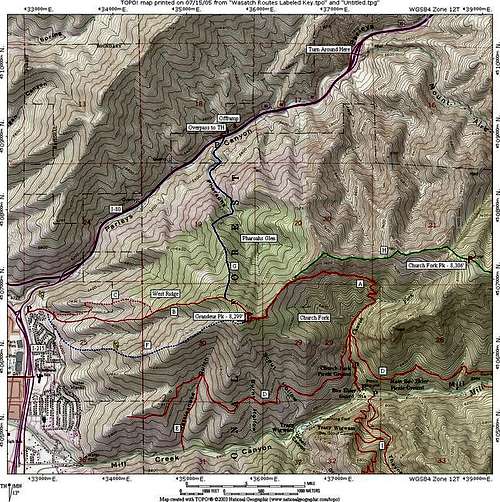 The Church Fork Route is marked "A" on the map.
Route Description
From the trailhead, follow the trail for the first 0.7 miles up through the forested Church Fork drainage. From there, the trail continues up hill in a series of switchbacks for another 0.5 of a mile. At this point the trail starts heading in a more Westerly direction towards the peak.Continue along the trail in a westerly direction for 0.8 miles to the top of Mill Creek Ridge. From this point you can see down into Parleys Canyon (I-80). Continue Westerly for another 0.6 miles to the top. This is the steepest part of the trail, but the trail is well graded and well used.
As you approach the summit, the views of the Salt Lake Valley really open up. You can head the faint hum of traffic echoing up from the city, which is a stark contrast to the rather quiet trail that you ascended.
The route is 5.2 miles round trip with 2340 feet elevation gain.
 Descending the Church Fork Trail.
 Photo taken from east of Grandeur Peak. Much of the Church Fork Route can be seen in the photo.
 Essential Gear
Normal hiking gear.In winter, snowshoes and trekking poles are usually needed.