
|
|
Route |
|---|---|
|
|
40.81020°N / 110.6231°W |
|
|
Scramble |
|
|
A few days |
|
|
Class 2+ |
|
|
Getting There
From the traffic light in Kamas and the intersection of Route 248 and 32, head north 0.1 to SR 150 (Mirror Lake Highway). Turn Right onto SR 150 and follow for 49 miles to FR 058 aka "North Slope Road", and follow for 21.2 miles (From SR 150) to the intersection with another dirt road heading north-south. Turn right and follow the road a very short distance and to where it crosses the West Fork Blacks Fork River. Shortly after this, look for a minor turn-off on the right. Drive this short road to the trailhead.
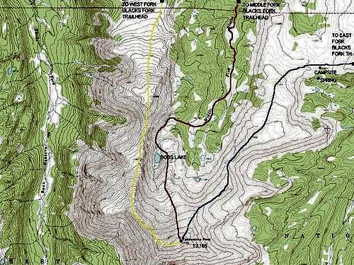 Red = Bobs Lake Route.
Route Description
This is probably the most used route to Tokewanna Peak, but the trail is still not used that much and can be hard to follow.
From the trailhead follow the gentle trail all the way south to Bobs Lake. The trail is hard to follow in places, so take a good map. You can't get too lost, as the trail follows the river the entire way, so as long as you are near the river, you are at or near the trail. There are several boggy places and un-bridged stream/river crossings.
Half way to Bobs Lake, you will cross the Bear River-Smiths Fork Trail, but it is very easy to miss the junction. The trail gets harder to find after the junction. Continue on the trail to where the stream has a major divide and where two cirque basins are visible near the headwaters. The cirque on the left (east) contains a small lake and good campsites. The cirque on the right (west) contains Bobs Lake just above timberline. Either cirque has routes to the summit of Tokewanna, and both cirques are about 10.5 miles from the trailhead.
From Bobs Lake, you can climb south for 2,000 feet towards the highly visible summit of Tokewanna. Photo of route. Parts of the route are rocky, and parts are grassy. From the eastern cirque, you can climb southeast to the Northeast Ridge of Tokewanna and follow it to the summit. This route is a bit more rugged than the Bobs Lake route because of more boulders and steeper slopes, but neither route has any major difficulties.
The total round trip distance is 25 miles round trip and usually takes two long or three shorter days.
Essential Gear
A good pair of boots is needed.