
|
|
Mountain/Rock |
|---|---|
|
|
40.64430°N / 115.9911°W |
|
|
Elko |
|
|
7368 ft / 2246 m |
|
|
Overview


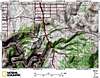
Spring Canyon Mountain has an elevation of 7,368 feet and a prominence of 948 feet and is located in the northern Pinon Range, about 8 miles southeast of Carlin and 18 miles southwest of Elko in northeastern Nevada. Much of the surrounding area, including the summit, are on BLM administered lands.
From the summit, you can see the small city of Elko beyond nearby Grindstone Mountain to the northeast and the town of Carlin to the northwest. The northwest view also provides an outstanding vantage of Carlin Canyon, just east of Carlin, and the dual-bore Carlin Tunnel through which pass the westbound and eastbound lanes of Interstate 80. Immediately to the south of the Carlin Tunnel are the Union Pacific’s twin tunnels. The views from the northeast to the south-southeast are dominated by the East Humboldt Range and the Ruby Mountains.
 Summit view to NW. Summit view to NW. |
 Summit view to NE. Summit view to NE. |
 Summit view to E. Summit view to E. |
Getting There
From I-80 at Elko, Nevada, take exit 301 (Mountain City Highway/NV-225). Proceed south on Mountain City Highway about 0.9 miles, then turn left onto Idaho Street. Proceed northeast on Idaho Street about 0.8 miles, then turn right onto Fifth Street/NV-227. Proceed southeast on Fifth Street about 0.5 miles, then turn right onto Wilson Avenue. Proceed southwest on Wilson Avenue, which becomes Bullion Road after about 0.25 miles. After about 2.6 miles from making the turn onto Wilson Avenue, the pavement ends and Bullion Road becomes a hardpack road and then later a dirt road.From the point where the paved Bullion Road ends, 27.1 miles of hardpack and mostly dirt roads will take you to the base of Carlin Benchmark. Turn off the main dirt road after 11.5 miles. From there it is another 15.6 miles on unimproved roads that are not maintained. There are deep ruts in areas and may be impassable after rain. Also, there are some sharp turns along this route as well as open range, so please drive with caution.
 Dixie Flats, Grindstone Mtn. Dixie Flats, Grindstone Mtn. |
 Woodlands view. Woodlands view. |
 BLM sign. BLM sign. |
These roads take you through the sagebrush and juniper woodlands of the Dixie Flats, some of it along and across the same route that westward bound emigrants took in the 1840s and 1850s on the Hastings Cutoff along the South Fork Humboldt River. Leaving the flats, the route winds into the lower reaches of the northern Pinon Range.
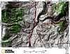
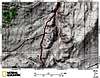
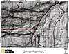
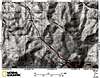
Due to the number of dirt roads in the area and the resulting complexity, the below 1:24,000 scale topo maps are provided to guide you in. There is a cattle guard at the end of the driving route at the southwest base of the mountain and you’ll see a road to the right just before the cattle guard. From this point, you can park off to the side of the road and begin your hike, or you can drive up the other road to the summit.


 9 of 9
The road runs up the southwestern slope of the mountain then cuts to the east before approaching the summit from the south. The road ends at a radio facility with an antenna tower, solar panels, and maintenance building – not quite to the summit. At the road’s end, you’ll see a rock formation. This is not the summit, which is on a higher rock formation to the north a short distance. This road is 1.55 miles long with several areas where high clearance is needed if you’re in a vehicle. Aside from that, it’s a good road; I don’t believe I had to use 4WD on this. An additional 0.15 miles on foot with a net gain of 93 feet gets you to the summit. If hiking, this is a Class 1 hike from the road at the base of the mountain with a one-way distance of 1.70 miles and 703 feet net elevation gain.
 West slope view. West slope view. |
 Below the summit. Below the summit. |
 Final approach to summit. Final approach to summit. |