
|
|
Mountain/Rock |
|---|---|
|
|
38.10110°N / 119.323°W |
|
|
Mono |
|
|
11778 ft / 3590 m |
|
|
Overview
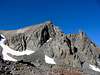
This is one of the best-looking peaks overlooking the Bridgeport Valley, but due to its location amongst taller peaks, can only be seen from certain vantage points. The hanging valley at the base of this peak has a series of lakes with some of the best fly fishing in the entire state.You won't find the name of this peak on the 15' map, or even on the 7.5'. It has no official name, but unofficialy, according to the locals, it is Tamarack Peak, with Tamarack Creek running from its base, emptying into Tamarack Lake before heading down into the Big Valley.
From the summit, there are fine views of Twin Peaks, Matterhorn Peak, Dunderberg Peak, Mt. Conness, North Peak, and many others. The trailhead is high, the terrain is fun, and the distances are good for a half-day scramble.
 |  |  |  |  |
Getting There
The directions to the trailhead are not difficult, but for once I have to offer the caveat that four wheel drive is probably necessary, both for clearance and for traction.From Bridgeport: Proceed southbound on Hwy 395 for about 4.5 miles, and watch for the Green Creek turnoff on the right. It is marked by a road sign and a stone marker inset with a bronze plaque.
From south of Bridgeport: About 5 miles before arriving in Bridgeport on Hwy 395, you will pass the Virginia Creek Settlement, a restaurant, campground, and motel, on the left side of the road (good food to be had here). Across the road, on the right, is Willow Springs, an RV park. Continue for a half mile, and the turnoff to the left is marked with a road sign and a stone marker inset with a bronze plaque.
Once on the Green Creek Road, continue for 1-2 miles, and watch for a right-hand turnoff marked as Upper Summers Meadows. Take this right turn, and stay on the main road, ignoring many lesser-used side roads. Soon you will reach Upper Summers Meadows, and the road will climb up the hillside to the south of the Meadows. As you climb above the Meadows, the road will narrow and steepen, and eventually the aspens will close in on both sides and scrape your car. A couple of miles before road end, there is a steep, loose section, and just before road end, the road steepens dramatically, with large exposed rocks and tree roots mixed with loose gravel and soil. When the road ends at a turn-around, you are there.
This peak is also accessible via West Lake from the Green Creek trailhead, but this is further and more difficult.
 |  |
Red Tape
No red tape. The land is public, free camping is available at the trailhead, free parking, no wilderness permits required.When To Climb
Unless you want a long slog to the trailhead, climb this peak in the late spring, summer, or early fall. The trailhead is high (~8,900'), so snow arrives early and stays late. This basin sees very little traffic anytime, but in the winter next to none, except on the Crater Crest which is popular with skiers.Camping
Free camping everywhere. The trailhead is an excellent spot, with Tamarack Creek close by, plenty of shade trees, and no hassles. Most anywhere along the Summers Meadows Road not bordered by a fence is good too. But the trailhead is the best spot.Mountain Conditions
Web-cam? I don't think so. Your best bet for weather is the NWS. The Bridgeport Ranger Station may be able to offer some insights.Gasoline
Caution -- Extremely high fuel prices in Bridgeport!Unreasonably high fuel prices in Bridgeport motivated me to add this section. There are 2 filling stations in Bridgeport, and both are owned by the same shyster. The fuel prices are often a dollar or more per gallon higher than surrounding areas. With this in mind, I want to recommend to everyone using a trailhead in the Bridgeport area to fill up well before you arrive.
If arriving from the north, fill up in Minden/Gardnerville, or next best, at Topaz Lake. Coming in over Tioga, Lee Vining is also expensive, but (slightly) less than Bridgeport. From the south, Bishop is the best bet, but Mammoth is 40 - 50 cents per gallon less than Bridgeport. Coming over Sonora Pass, I guess you're out of luck unless you buy enough in Sonora to get over and back.
If you for some reason do find yourself in need of fuel in the Bridgeport area, Mono Village (at Upper Twin Lake) has fuel for 20-30 cents cheaper than in town.
While the fuel prices are a rip-off, other merchants in town are more reasonable, especially restaurants.