
-
 20186 Hits
-
 72.08% Score
-
 2 Votes
|
|
Route |
|---|---|
|
|
43.02968°N / 42.99502°E |
|
|
Mountaineering |
|
|
Summer |
|
|
A few days |
|
|
Russian 2B / +PD |
|
|
Overview
Summit: Mt TetnuldiRoute: Normal Route / SW Ridge
Grade: Russian 2B
Region: Upper Svaneti, Georgia
Height: 4858m
Date: 13/07/17
Approach and General Information
From either Tbilisi or Kutaisi international airport you will need to get a bus / transfers to the town of Mestia in Upper Svaneti. Here you will find some small shops for basic supplies, but anything remotely specific that you need should be brought from Tbilisi / your home country. Gas canisters are available in a few shops in Mestia, but not much else you are likely to need.
There are 3 options to start this route; either from the village of Adishi, Zabeshi or from Tetnuldi ski-resort. There are no public bus services that we were aware of, so you will need to take a taxi to any one of these places.
We started from the ski resort at around 2700m, which is the highest point you can drive to. This is accessed by dirt road from the Ughviri Pass, around 13km on the road from Mestia to Ushguli. Follow this track up through the lower stations and look out for a signposts (Tetnuldi is signposted!) and a path on the right on a hairpin bend at around 2700m, just below a mid-station.
Accommodation
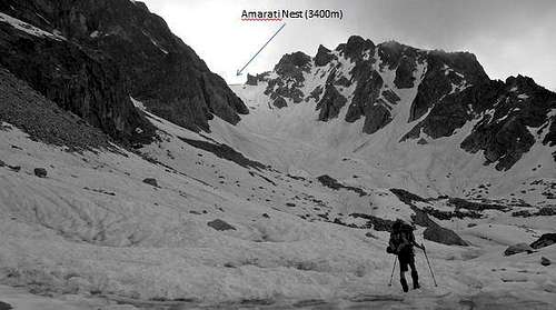
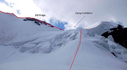
Camping is the only option on Tetnuldi. There are three camp sites. Camp 1 is situated below the moraine on the grassy slopes high above Adishi, before you ascent up the snow fields to the glacier. Camp 2 is situated on the lower section of the glacier. Camp 3 is at the point at which the route joins the SW ridge, and is only 500m below the summit. There is some relatively steep snow climbing to do before reaching this Camp 3, which would be difficult and certainly very tiresome with heavy packs.There is also an intermediate camp, Amarati Nest, on a col between Camp 1 and Camp 2 at around 3400m.
Route Description
The route is intermittently sign posted from both Zabdeshi and Adishi. From our start at the Tetnuldi ski resort a sign-posted track at just under 2700m traverses grassy slopes for around 2-3 hours taking you to the bottom of the moraine field and Camp 1 (circa 3000m), a sensible place to spend the night. From Camp 1, some discreet cairns will (may) lead you through the moraine to the bottom of a snow slope leading up to a col and the intermediate camp site, Amarati Nest (1-2 hours).From Amarati Nest the route heads directly up the snow slopes to the glacier. These slopes are fairly steep and a demanding climb with a heavy pack, best to tackle it in the morning when the snow is still firm.
Time from Amarati Nest to Camp 2 is 1.5-2 hours.

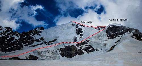
When you reach the glacier you will find Camp 2 (3700m), which we felt was the best place to use as a base. The route then traverses the relatively flat (and apparently stable) glacier north towards a small cliff to the left of some big seracs. To the left of these cliffs is a steep snow slope (maybe 45 degrees in parts) of about 100m which leads you to the upper section of the glacier where the route starts to traverse under the West Face towards the SW Ridge. There was evidence of some rock fall below this cliff, so don’t hang about. The route then continues to climb staying to the right, fairly close to the top of the seracs, until you reach a high point about 200m below Camp 3. From here the route undulates a little before a steep but obvious line up to Camp 3 and the point at which the route joins the ridge.
Time from Camp 2 to Camp 3 is between 2.5 – 3.5 hours.
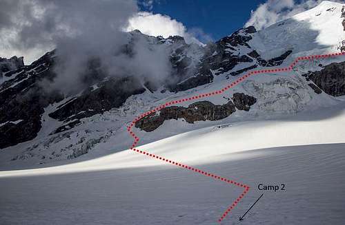
On the section that traverses under the West Face the glacier appears to be quite unstable and there are a number of large crevasses. Thankfully, there is a good amount of distance between you and the rather intimidating seracs on the face above.
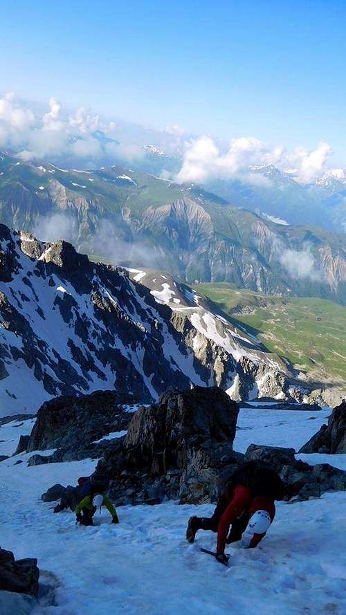
From Camp 3 the route follows the ridge for about 1km with a 550m incline along the ridge. Unfortunately we were unable to complete this section due to weather conditions on summit day, but having spoken to climbers that managed it the day before, it seems that some easy rock scrambling is required and depending on conditions you may find some icy sections up to 45 degrees.
Time from Camp 3 – Summit is circa 3 hours.
Essential Gear
Boots, crampons, ice axe (2 axes may be useful if the summit ridge is icy), rope etc., helmet, ice screws. Camping gear.Maps and Guidebook
A rudimentary trekking map and a useful guidebook are available for free from the tourist information office in Mestia.Other trekking maps are available in some shops in Mestia, but aren’t that much better than the information available from the Tourist Information.