


Bodhi - Oct 8, 2003 3:39 pm - Hasn't voted
3 gates that I counted (need clarification) ...I counted three gates from the dirt parking lot just off of Hwy 75 that I had to pass. The first one was @ the very bottom by the parking lot. The second was painted red & just after the fork in the road on Yonah Mountain Road. And the third was on the way to the "Staging Area" w/ a sign on it that read: "Road Closed." Which gate are you referring to that it is 2.7 miles to the summit from that point? Also, what is the total distance from the dirt parking lot at the very botton just off of Hwy 75 to the "Upper Landing Zone?" Thanks.

marcminish - Oct 15, 2003 3:19 pm - Hasn't voted
Re: 3 gates that I counted (need clarification) ...It's 2.7 miles from the first gate (the one right by the main road and the parking lot) to the Staging Area. Look on the Yonah Mountain page, I added the PIN code to the "red tape" section. The second gate is just as you described it, right after the fork in the road at the top of a rather steep section of gravel road. Usually this gate is unlocked and standing open, but occassionaly it too is shut tight. The third gate, which I have never seen unlocked, is just past the last house and, as far as I know, is only used by the army.
The map was actually drawn by somebody else. The next time you climb there you might see an older gentleman with a skipper's hat (one like the "skipper" wore in Gilligan's Island), walkie talkie, medical alert necklace and packing heat. He walks up the mountain every day and is very friendly and informative. He gave me the map. The difference between his map and my directions may be the source of the confusion. Let me know if you find mistakes in the Yonah page and I'll fix it pronto.
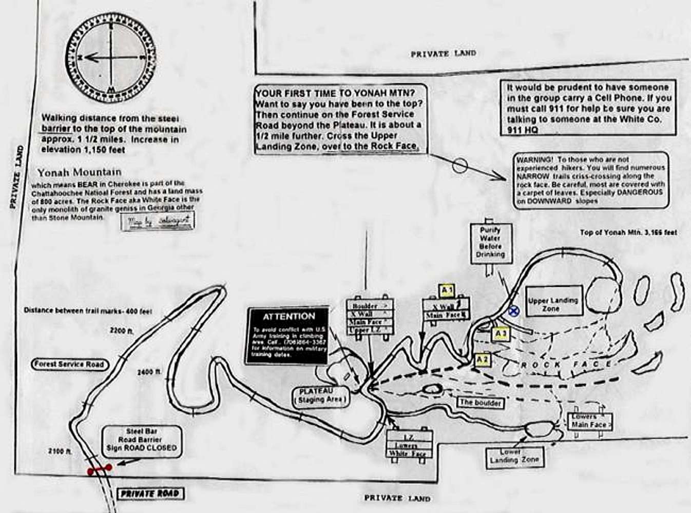
trackerbill - Jun 20, 2004 5:31 pm - Hasn't voted
Can't bring up mapFrom the "old gentleman" that packs heat! I wanted to see just what my map looks like on your sit but I've tried several times and all I get is an x in a small box and "Yonah Mountain Photo _id 23297. ( my computer appears to be scanning for the item) What am I doing wrong.?{ I joined the list with the user name "trackerbill" so I should have authorization to view.
I was somewhat hurt by you referring to my map as "crude and hand drawn." It was made by an overlay method of an govt aerial map. Compass point and elevation markers are reasonably accurate as are 400 ft. distance road markers.
As for the steel bar across the road at the beginning of the FSR ( Forest Service Road ) be advised the 5th Ranger Training Batt. train on the mountain on Wednesdays and Thursdays. Not every week but at least 26 times a year. If you are considering climbing mid week it would be prudent to call them ahead of time.
FREE SOLO IS THE ULTIMATE CLIMBING ADVENTURE!
trackerbill - Jun 21, 2004 12:29 pm - Hasn't voted
I can now pull the map!I haven't got a clue as to why my previous attempsts would not dislay the map. The size is rather small for down loading. Perhaps I should place a larger version on my profile along with some photos of the rock face.
I have a warning for those who obtain the access code
to the gate at the entrance to the private road. I would stongly suggest you do not drive up and park near the steel bar. The "mayor" of the road is quick to call the Law Enforcement team of the Forest Service. It is possible you might find a ticket on your vehicle when you come back down from your climb.
Take heart, it has been years in the works but the Forest Service has put out bids for "timber cutting"
at the planned parking area at the base of the the rock face.
marcminish - Jun 25, 2004 4:00 pm - Hasn't voted
Re: I can now pull the map!Ditto to what trackerbill says about the gate. Only use the code (#2323) to ferry gear.
I was there last weekend and the natives are as hostile as ever towards climbers. A couple of folks firmly told me to turn my truck around which I did so as not to engender further climber resentment.
I sure wish the 2nd access road would hurry up and get built.


Comments
Post a Comment