
|
|
Area/Range |
|---|---|
|
|
59.12523°N / 159.85107°W |
|
|
Spring, Summer, Fall, Winter |
|
|
Overview
Togiak National Wildlife Refuge is about 7300 square miles (4.7 million acres) and is located in Southwest Alaska. It is the third largest wildlife refuge.It is North of the Alaska peninsula and is bordered by the Bering Sea. It is remote and undeveloped in a way that does not compare with with wilderness in the lower 48. Much of this wilderness will not see a human being for years at a time.
The Refuge is adjacent to both Wood-Tikchik State Park and Yukon Delta National Wildlife Refuge. The combined size of these contiguous public wilderness areas is over 38,000 square miles. 13 states including states like Indiana are smaller than this wilderness. This entire area is amazingly remote, undeveloped and unpopulated.
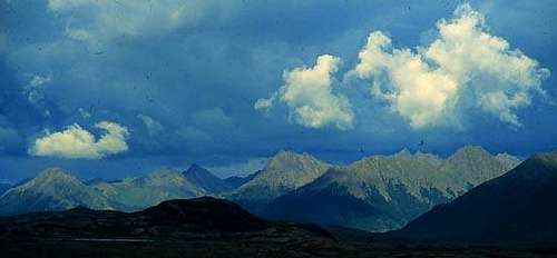 The southwestern Ahklun Mountains. Jason Briner (with permission)
Ahklun Mountains dominate the refuge in the north and Bristol Bay to the south. The Ahklun Mountains encompass 80 percent of the refuge. The Ahklun Mountains form the highest range in this part of Alaska. The range is about 150 miles long in a Northeast-Southwest direction and reaches its highest elevations in the northeast, where summits exceed 5000 feet. There are dozens of glaciers.
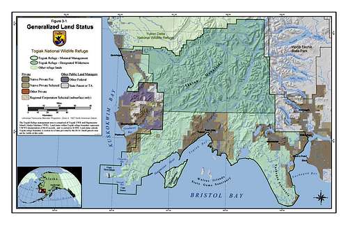 Togiak National Wildlife Refuge is Adjacent to Wood-Tickchik State Park
The Kuskokwim River is on the Northwest side and The village of Togiak is on the South end. Tundra covers most of the mountains and valley bottoms. Black spruce and white spruce are patchy. Birch and alder cover the low hills along the major rivers. The large rivers are full of salmon in the summer and beavers are numerous in the creeks. Rainbow trout are common.
Climate. Average annual precipitation ranges from 19 to 25 in (480 to 640 mm). Average annual temperature ranges from 29 to 33 oF (-2 to 1 oC).
Getting There
The most common way to get the the refuge is by plane, it could be done by boat but is not very practical, it is only theoretically possible by foot and completely impossible by road. June conditions, Seth Beaudrealt
It's about 350 miles from Anchorage to Dilligham and there are daily flights. Dillingham is where the refuge office is located. From Dillingham you can charter a bush pilot to fly you into the refuge. In the summer landing in the bush means finding an unimproved landing "spot", usually on water (more predictable) or a gravel bar in a river (take your chances on finding one within miles of where you want to go).
If you are flying into the refuge, I have a great deal of experience with this Bush Pilot and can guarantee he is the best.

If you are entering the Northeast side of the refuge, like if you are trying to get to somewhere near the Kanektok River it would probably be best to go from Anchorage to Bethel and enter the refuge from there.
Rivers
Most trips into this area are float trips from headwater lakes to a river's mouth. Nearly everyone entering Togiak Refuge does a fly-in trip with a bush pilot. All businesses must have permits to operate within Togiak Refuge. Contact Togiak Refuge with questions regarding permitted operators. More information on permits can be obtained from Alaska fish and Wildlife.The Kanektok, Goodnews, and Togiak drainages containing salmon, Dolly Varden, and rainbow trout. The rivers are all free flowing, there are no dams in this area. Parts of all three of these rivers are in the Togiak Wilderness.
Kanektok River
(map)Length: 92 miles; 73 miles within the Togiak Refuge Wilderness Area.
River Conditions: Rocky and swift in upper half; lower half has many braided channels, fast water and sweepers; Heavy motorboat traffic in the lower 20 river miles. The Kanektok River is the most visited river in Togiak Refuge.
Goodnews River
Length: 55 miles, 27 within the Togiak Refuge Wilderness Area.
River Conditions: Moderately braided channel, fast moving water in the upper portion, lower river tidally influenced; limited camping downstream of confluence. Jetboat traffic, especially in downstream portion of river.
Togiak River
Length: 58 miles, 40 in the wilderness area.
River Conditions: One main channel, gentle current, lower 5-8 miles tidally influenced; boat traffic entire length of river. Especially during the salmon fishing season.
History
The indigenous peoples here are the Yup'ik Eskimos. There is evidence of human habitation in this area for 5000 years. Many people living in this region today live a subsistence lifestyle. Locals rely on wildlife for meat, it is easily possible to provide all the meat a family can eat from the land. One of the main purposes of Togiak National Wildlife Refuge is to continue to provide subsistence opportunities for local people.Togiak Refuge was established in 1969 to protect and preserve the outstanding wildlife values. The refuge was expanded to 4,156,522 acres and established as Togiak National Wildlife Refuge in 1980. Congress enacted the Alaska National Interest Lands Conservation Act saying,
it is the intent of Congress in this Act to preserve unrivaled scenic and geological values associated with natural landscapes; to provide for the maintenance of sound populations of, and habitat for, wildlife species of inestimable value to the citizens of Alaska and the Nation, including those species dependent on vast relatively undeveloped areas; . . . to protect the resources related to subsistence needs; to protect and preserve historical and archeological sites, rivers, and lands, and to preserve wilderness resource values and related recreational opportunities including but not limited to hiking, canoeing, fishing, and sport hunting, within large Arctic and subarctic wildlands and on free-flowing rivers; and to maintain opportunities for scientific research and undisturbed ecosystems
Togiak National Wildlife Refuge conserves habitat for hundreds of bird species. Birds from the North American Pacific Flyway and other migration routes fly through the area. Over a million seabirds nest on ledges and in burrows along the refuge's sea cliffs, primarily in the Cape Peirce area.
external links
US Fish and Wildlife TogiakWalrus Islands State Game Sanctuary
Warehouse Mountain Hike
OK this one is remote. Honestly you will not travel to the area to do this hike even though it is very nice, but if you are in South West Alaska, specifically in Dillingham, don't miss it. From Dillingham drive out Kanakanak road to Aleknagik Lake road. Take this road about 10 miles to Nunavauguluk Lake road. Warehouse Mnt is along side this road on the right as you head toward the lake. In all seasons except winter, walk up the North side, in winter I hear that snow machines bring the skiers to the top.
It is an easy couple mile hike that is not very steep up to a spectacular view of Togiak National Wildlife refuge, Nunavaguluk Lake, Aleknagik Lake and the Nushagak river. There is evidence of a very old native camp in a saddle. An archaeologist suggested that it was probably a caribou hunting site, because the view is so expansive, the traveling herds could be spotted.
Lakes
more to come in this section.....Lakes in the Ahklun Mountains, Alaska
Alaknagik Lake
Amanka Lake
Arolik Lake
Awayak Lake
Canyon Lake
Cascade Lake
Elva Lake
Gechiak Lake
Gold Lake
Goodnews Lake
Heart Lake
High Lake
Ilanik Lakes
Kagati Lake
Kanuktik Lake
Kisaralik Lake
Klak Lake
Kukaktlim Lake
Lake Aleknagik
Lake Nerka
Lake Nunavaugaluk
Little Togiak Lake
Lynx Lake
Middle Fork Lake
Mikchalk Lake
Nagugun Lake
Nanavochtshak Lake
Nanvakfak Lake
Nenevok Lake
Nimgun Lake
Norseman Lake
Nunavachak Lake
Ongivinuk Lake
Pegati Lake
Pungokepuk Lake
Togiak Lake
Tshachaling-Atachtoli Lake
Ualik Lake
Upper Togiak Lake
West Togiak Lake