


-
 3077 Hits
-
 79.04% Score
-
 10 Votes
|
|
Route |
|---|---|
|
|
45.77554°N / 7.57566°E |
|
|
Hiking |
|
|
Spring, Summer, Fall, Winter |
|
|
Half a day |
|
|
F (Easy) |
|
|
Note
|
La montagna chiama i suoi figli, ed essi rispondono fedelmente al suo appello… Osvaldo Cardellina, Diario alpinistico, 1964-65 Page texts: @ OsvaldoCardellina "Osva", passed away on May 2, 2022. Page owners: Christian Cardellina e Osvaldo Cardellina. Any updates from September 12, 2022: Antonio Giani, page administrator, friend and climbing companion. Testi della pagina: @ OsvaldoCardellina "Osva", scomparso il 2 maggio 2022. Proprietari pagina: Christian Cardellina e Osvaldo Cardellina. Eventuali aggiornamenti dal 12 settembre 2022: Antonio Giani, amministratore della pagina, amico e compagno di salite. |
All Saints Overview
This crossing is part of the wide Basin Verrayes and Saint Denis Communes. Many, I would say almost all, are intended for hikers as well as for those taking their first steps towards the Mountain. Both for ease of routes to the Southern exposition which eliminates many problems in the beginning and in the end of season. All these routes are rewarding and allow great views over the whole Valley of Aosta with remarkable photographic possibilities. Among these you want to point out here the "Tour de Saint Evence", beautiful summer stroll among magnificent forests and beautiful hike through snow shoes starting from the bottom from the little and tiny Villages of Del, Plau and Semon, or from the top with reverse path from Col Saint Pantaleon accessible by car even in winter on the South and from the opposite or Torgnon Municipality through the Regional Road, where is normally closed and you still can quite extend to the tour in question. A "tour of green", green as the color that we gave to the title, as is done over large areas meadows (the "Plan de Verrayes") stretching between these two municipalities reaching the East and those of Saint Denis the next Forest Cheresoula or Chérisoulaz at the foot of the Hill Saint Pantaleon (1.650m). As the green slopes that rise from East to West to Becca d'Avèr (2.469m), the highest elevation of this whole wide basin, the Cima di Longhede (2.416m), the second as elevation, and, down below to the West, to more modest Monte Andér (1.901m) and Cima de la Pesse (1.738m), now on the edge with the adjacent Valley of Saint Barthélemy. But also a "tour white" as the color of snow that blankets in winter these modest summit and then slowly diluted with the arrival of spring, leaving here and there patches of snow fields among the meadows, typical autumn colors, go, lighting up to revert to vast stretches of countryside with the advance of the same in a perpetual natural cycle. A white that offers good and "comfortable" winter excursions on skis or by snowshoes. Even and especially in Saint Evence ...
![]()
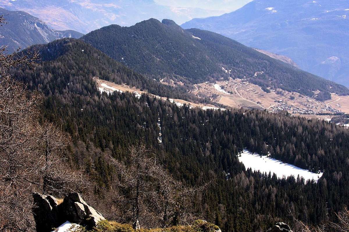
St. Pantaleon Hill towards Saint Evence above St. Denis, ascending on Cima di Longhede, by Antonio
Questa traversata rientra in quelle della Conca di Verrayes/St. Denis. Molte, anzi direi quasi tutte, sono rivolte agli Escursionisti ed anche a coloro che muovono i primi passi verso la Montagna. Sia per la facilità degli itinerari che per l'esposizione a Mezzogiorno che elimina molte problematiche in inizio e termine di stagione. Tutti questi percorsi sono gratificanti e permettono grandi vedute sull'intera Valle di Aosta con notevoli possibilità fotografiche. Tra questi si vuole qui segnalare il "Tour de Saint Evence", bella passeggiata estiva tra magnifiche foreste, nonché splendida escursione tramite racchette da neve con partenza dal basso dai Villaggetti di Del, Plau e Semon oppure dall'alto con percorso inverso dal Col Saint Pantaleon, raggiungibile in auto anche in inverno sul lato Meridionale mentre dall'opposto o del Comune di Torgnon la Strada Regionale viene di norma chiusa e comunque si può prolungare di non molto la gita in questione. Un "tour verde, verde come il colore che abbiamo dato al titolo, poiché viene effettuato al di sopra di grandi estensioni prative (il "Plan de Verrayes") che si allungano tra questi due comuni raggiungendo ad Oriente quelli di St. Denis e la successiva foresta di Cheresoula o Chérisoulaz ai piedi del Colle St. Pantaleon (1.650 m). Verde come i pendii che salgono da Est verso Ovest alla Becca d'Avèr (2.469 m), massima elevazione di tutta questa ampia conca, alla Cima di Longhede (2.416 m) e, laggiù in fondo verso Occidente, ai più modesti Monte Andér (1.901 m) e Cima de la Pesse (1.738 m), ormai ai margini con l'adiacente di St. Barthélemy. Ma anche un "tour bianco", come il colore della neve che ammanta in inverno queste modeste Sommità per poi lentamente diluirsi con l'arrivo della primavera lasciando qua e là chiazze di nevai tra i prati che, dai colori tipicamente autunnali, van accendendosi sino a ritrasformarsi in vaste distese verdeggianti con l'avanzare della medesima in un ciclo naturale perpetuo. Un bianco che consente belle e "comode" gite invernali con gli sci o le racchette da neve. Anche e soprattutto a Saint Evence ...
![]()
From Del, Plau, Semon Hamlets or from Col San Pantaleon?, by Osw
But from where? From Conca Verrayes / Saint Denis Municipalities or from Valtournanche adjacent Valley? Let's say the first, because the Regional Road that leads from the Municipality of Torgnon towards the Col Saint Pantaleon in winter is rarely open and then in this case the starting point is unique, while the opposite side is accessible even in the bad season. Also, while in the first case it is necessary only to turn the starting point from the hill, by the Saint Denis is possible to opt for different solutions:
1) - with departure from the hill with the two alternatives of a) - start crossing the watershed reaching the Chapel St. Evence and this down towards Semon and then up to the same; b) - now down the hill towards Semon (1.359m) and Plau (1.305m) and then reach the chapel and reverse path crossing on watershed with Valtournanche (Torgnon).
2) - starting with the same, or, wanting to stretch a little path, from the adjacent Village of Del (1.260m) and from these c) - climb immediately towards the hill and take the circular path as in the first case; d) - as in the second, up now to St. Evence, cross the divider toward the St. Pantaleon and finally "quietly" to descend again to the same little villages. We recommend this very last choice, as more logical and "comfortable", but often we made the opposite. Maybe the light of a beautiful full moon ...
Ma partendo da dove? Dalla Conca Verrayes/St. Denis o dalla Valtournanche? Diciamo dalla prima, perché la Strada Regionale che dal Comune di Torgnon porta al Colle di St. Pantaleon in inverno é assai raramente aperta e poi in questo caso il punto di partenza risulta univoco, mentre sul versante opposto é agibile anche nella cattiva stagione. Inoltre, mentre nel primo caso é necessario esclusivamente rivolgere il punto di partenza dal colle, dal Comune di St. Denis risulta possibile optare per diverse soluzioni:
1) - partendo dal colle con le alternative di a) - iniziare la traversata sullo spartiacque raggiungendo la Cappella di St. Evence e da questa scendere verso il Villaggio di Semon per poi risalire al medesimo; b) - scendere subito dal colle verso i Villaggi di Semon (1.359 m) e Plau (1.305 m) e quindi raggiungere la Cappella e con percorso inverso attraversare.
2) - iniziando dai medesimi, oppure, volendo allungare d'un poco il percorso, dall'attiguo di Del (1.260 m) e da questi c) - salire subito al colle e compiere il percorso circolare come nel primo caso; d) - come nel secondo, salire subito a St. Evence, attraversare il divisorio verso il St. Pantaleon ed infine "tranquillamente" discendere nuovamente ai medesimi. Noi consigliamo proprio quest'ultima scelta, poiché più logica e "comoda", anche se spesso abbiam realizzato il contrario. Magari al lume d'una bella Luna piena ...
From St. Pantaleon Hill (1.650m) with homonym Chapel crossing on watershed between St. Denis/Torgnon towards St. Evence, by Osw 2015
![]()
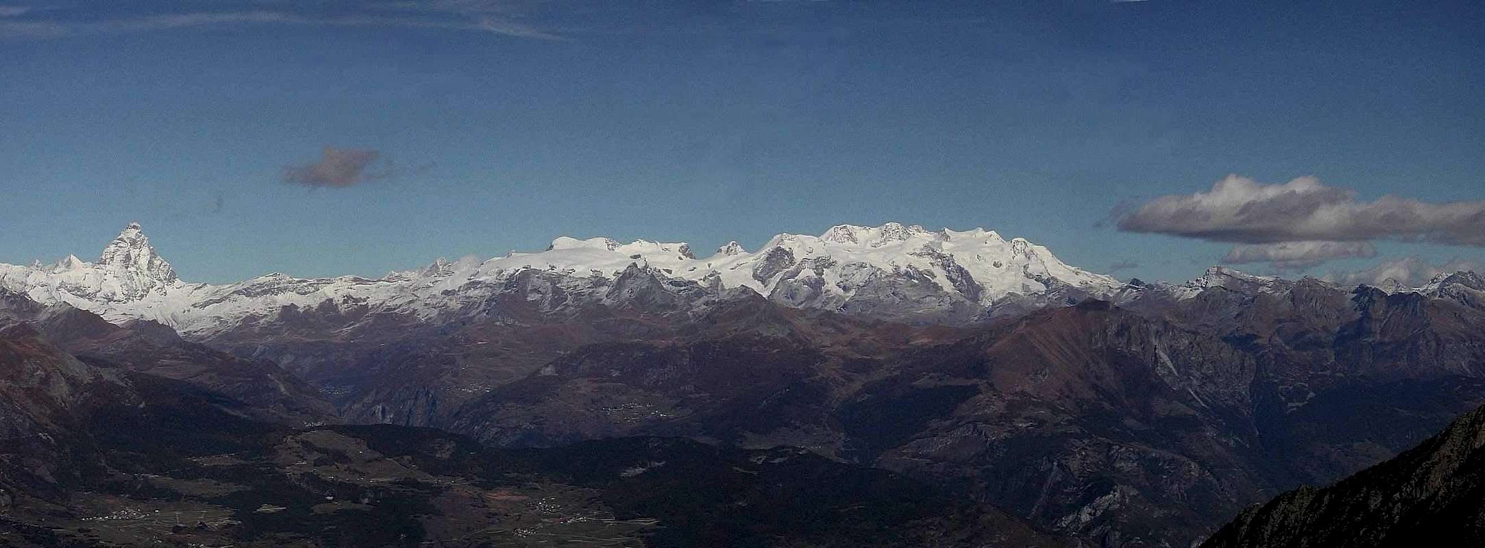
Tour of St. Evence above St. Denis and under Monte Rosa, by Maria Grazia Schiapparelli
1) - partendo dal colle con le alternative di a) - iniziare la traversata sullo spartiacque raggiungendo la Cappella di St. Evence e da questa scendere verso il Villaggio di Semon per poi risalire al medesimo; b) - scendere subito dal colle verso i Villaggi di Semon (1.359 m) e Plau (1.305 m) e quindi raggiungere la Cappella e con percorso inverso attraversare.
2) - iniziando dai medesimi, oppure, volendo allungare d'un poco il percorso, dall'attiguo di Del (1.260 m) e da questi c) - salire subito al colle e compiere il percorso circolare come nel primo caso; d) - come nel secondo, salire subito a St. Evence, attraversare il divisorio verso il St. Pantaleon ed infine "tranquillamente" discendere nuovamente ai medesimi. Noi consigliamo proprio quest'ultima scelta, poiché più logica e "comoda", anche se spesso abbiam realizzato il contrario. Magari al lume d'una bella Luna piena ...
 |
 |
 |
 |
 |
A little Legend & History
Why Saint Evence? The Legend of the Holy Evanzio, such as San Besso in Cogne over the Hill of Arietta and San Porciero in Champorcher, is brought back to the famous "Theban Legion" was completely destroyed. As Emeric of Villair de Quart, also Evanzio was a Hermit who had retired after the defeat of this headland. A bluff, at least visually, I reconnected with his two brothers Julien, who retired on the mountain above Fénis and Pantaleon near the Horn of Teodulo. But passing from Legend to History we must observe how the Chapel of St. Pantaleon, which stood on the site of a much older chapel of the thirteenth century, always dedicated to the same saint and which had both oratory, just below the hill of the same name (1.650m, 1.645m), is traced back to 1845/6 and inaugurated by Bishop Jourdain in the following year. Continuing on from this towards the South with a continuous series of ups and downs of the path, after about twenty minutes to reach, in the middle of the Forest Chérisoulaz, the deviation to the left (East), the Section de Creuvö and continuing on crinal meet some benches wood from which you can admire the beautiful panorama that opens onto the Central Valley of Baltea until the City of Aosta and beyond. With a last short downhill and bending slightly to the left you reach a grassy plateau with half a dozen wooden benches arranged in a circle and unfortunately at a TV repeater. Just to the right is the Chapel with entrance facing West. Inaugurated in 1727 and restored 30 June 1996 is dedicated to St. Evence, as we said a veteran of the Theban Legion, who on promontory built a primitive hermitage. So at least says in 1882 the famous writer-mountaineer Giuseppe Giacosa. This in ""Dans la Vallée d'Aoste Manuel du Touriste"", A. Lombardi Edition, Milan 1882, pages 27/31. It follows that Sant'Evanzio would liaise between the two brothers Giuliano Teodulo, inhabiting the hill located at the mouth of the Valtournenche and above Châtillon (South) and St. Denis (West); this is in fact the view reaches the tip of the Horn of Teodulo (3.468m) to the northeast and soon after Cervin or Matterhorn, is the Hermitage of San Giuliano located to the South-southwest over Fénis Common and now over the Baltea. As for the second, there are still traces of a remote cave above which has been built a chapel, as regards the first are not existence of signals of hermitages or chapels and moreover the place is not visible from this promontory since hidden by Cime Bianche (White Peaks). St. Evence, which legend says was founded by St. Evence brother of St. Théodule" Bishop of Sion into Valais Swiss, one can observe a forty bell towers scattered on average Valley of Aosta. But the legend is always and only legend, as history is history; sometimes the first has historical foundations and the second touches the legend. An intermediate step that can transform almost the Legend and History in the second turn into History romanticized or, if you prefer, legendary. This also applies to the figures of St. Pantaleon and St. Denis ...
But who was St. Pantaleon, which was dedicated on the Chapel Hill and just below, and Saint Denis from which it receives the name of the town below?
Let us return to the above, noting that in the "History of the Saints" are some of one and a little of the other, but above all, highlighting how the Western tradition comes from the East and that in the latter the boundaries between history and legend They are somewhat soft and labile. This applies to St. Théodule, St. Pantaleon that St. Denis who, like Julien, Porciero and Besso, Saints are not born and raised very religious in Aosta Valley, but imported. Even in some cases despite their nickname it was Frenchified. So from this famous "Theban Legion" which, apparently, produced more saints legionnaires arrived all these Saints & Hermits, among which is "saved" certainly St. Emeric was born and raised in Villair de Quart and then Bishop of Aosta. And the "Grecian" St. Pantaleon revered throughout most of Europe and in the Valley is protector of Commons of Chamois and Valpelline and chapels which are scattered throughout (Gimillan, Erèsaz at Emarese and the hill of the same name). Pantaleone, or even Pantaleo and greek Panteleimon was born in Nicomedia in 275 AD and died here on July 27 305), was an ancient greek holy. Christian and medical staff of Caesar Galerius was martyred during the persecution of Diocletian. It is considered, with the Saints Cosmas and Damian, as the patron saint of doctors and midwives, and is revered as such by many Christian Churches some throughout Europe. Pantaleon is venerated throughout the East, where it is called "The Great Martyr" and is invoked as a miracle worker. On Mount Athos, Greece, the monastery of the Russian community, one of the twenty still exist today on the holy mountain, is dedicated to him (Monastery of St. Panteleimon). his saint's relics are at the Basilica of Saint-Denis in Paris and the other in the city of Porto in Portugal. Saint Denis de Lutèce (in Paris of III° Century and always in Italy of the same III°) was the first Bishop of Paris, originally from the neighboring autonomous Municipality of St. Denis and venerated as a saint by the Catholic Church and then the first bishop of the French capital. The Catholic Church venerates him as a Saint, Martyr and Patron Saint of Paris and the Seine-Saint-Denis. Was martyred around 250 or 270 AD and was buried on the spot where they were first they erected the Basilica and then, on the same, or the Abbey or "Abbuy" of Saint Denis. The small religious building, with its bell tower is visible from several municipalities in the Aosta Valley. Here then we have to document a "more modern connection" between religious worship between France and Aosta Valley without having recourse, as for St. Evence, St. Théodule, St. Julien, San Besso and San Porciero, the usual Legend of the Theban Legion.
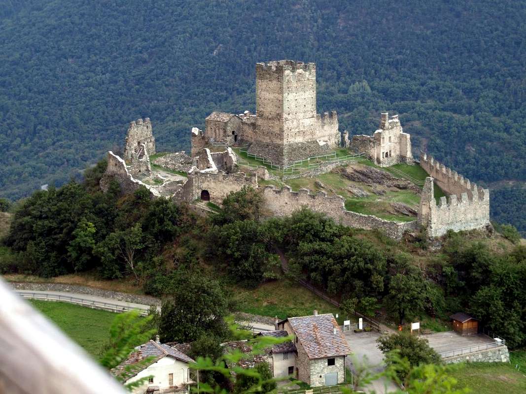
![]()
Cly Castle of 1351 neighboring St. Denis Common, by Osw
But who was St. Pantaleon, which was dedicated on the Chapel Hill and just below, and Saint Denis from which it receives the name of the town below?
Let us return to the above, noting that in the "History of the Saints" are some of one and a little of the other, but above all, highlighting how the Western tradition comes from the East and that in the latter the boundaries between history and legend They are somewhat soft and labile. This applies to St. Théodule, St. Pantaleon that St. Denis who, like Julien, Porciero and Besso, Saints are not born and raised very religious in Aosta Valley, but imported. Even in some cases despite their nickname it was Frenchified. So from this famous "Theban Legion" which, apparently, produced more saints legionnaires arrived all these Saints & Hermits, among which is "saved" certainly St. Emeric was born and raised in Villair de Quart and then Bishop of Aosta. And the "Grecian" St. Pantaleon revered throughout most of Europe and in the Valley is protector of Commons of Chamois and Valpelline and chapels which are scattered throughout (Gimillan, Erèsaz at Emarese and the hill of the same name). Pantaleone, or even Pantaleo and greek Panteleimon was born in Nicomedia in 275 AD and died here on July 27 305), was an ancient greek holy. Christian and medical staff of Caesar Galerius was martyred during the persecution of Diocletian. It is considered, with the Saints Cosmas and Damian, as the patron saint of doctors and midwives, and is revered as such by many Christian Churches some throughout Europe. Pantaleon is venerated throughout the East, where it is called "The Great Martyr" and is invoked as a miracle worker. On Mount Athos, Greece, the monastery of the Russian community, one of the twenty still exist today on the holy mountain, is dedicated to him (Monastery of St. Panteleimon). his saint's relics are at the Basilica of Saint-Denis in Paris and the other in the city of Porto in Portugal. Saint Denis de Lutèce (in Paris of III° Century and always in Italy of the same III°) was the first Bishop of Paris, originally from the neighboring autonomous Municipality of St. Denis and venerated as a saint by the Catholic Church and then the first bishop of the French capital. The Catholic Church venerates him as a Saint, Martyr and Patron Saint of Paris and the Seine-Saint-Denis. Was martyred around 250 or 270 AD and was buried on the spot where they were first they erected the Basilica and then, on the same, or the Abbey or "Abbuy" of Saint Denis. The small religious building, with its bell tower is visible from several municipalities in the Aosta Valley. Here then we have to document a "more modern connection" between religious worship between France and Aosta Valley without having recourse, as for St. Evence, St. Théodule, St. Julien, San Besso and San Porciero, the usual Legend of the Theban Legion.
Perché Saint'Evence? La leggenda di Sant'Evanzio, come quella di San Besso a Cogne oltre il Colle della Arietta e di San Porciero a Champorcher, viene ricondotta alla famosa "Legio Tebea" andata completamente distrutta. Come Emerico del Villair de Quart, anche Evanzio era un Eremita ritiratosi, dopo la disfatta, su questo promontorio. Un promontorio che, almeno visualmente, lo ricollegava ai suoi due fratelli Julien, fuggito sul monte sopra Fénis e Pantaleon al Corno del Teodulo. Ma transitando dalla Leggenda alla Storia dobbiamo osservare come la Cappella di Saint-Pantaleon, che sorgeva sui resti di una ben più antica cappella del XIII° Secolo sempre dedicata allo stesso santo e che aveva funzioni d'oratorio, appena al di sotto dell'omonimo colle (1.650 m, 1.645m), venga fatta risalire al 1845/6 ed inaugurata dal Vescovo Jourdain nell'anno successivo. Proseguendo da questa verso Mezzogiorno con una serie continua di saliscendi del sentiero, dopo circa una ventina di minuti si raggiunge, nel mezzo della Foresta di Chérisoulaz, la deviazione, a sinistra (Est), per il Sez de Creuvö e proseguendo sul crinale s'incontrano alcune panche in legno dalle quali si può ammirare il bellissimo panorama che apresi sulla Valle Centrale della Dora insino alla Città d'Aosta ed oltre. Con un ultima breve discesa e flettendo leggermente verso sinistra si raggiunge un vasto pianoro erboso con una mezza dozzina di panche in legno disposte circolarmente e, purtroppo, presso un ripetitore televisivo. Appena a destra sorge la caratteristica Cappella con ingresso rivolto ad Occidente. Inaugurata nel 1727 e ristrutturata il 30 giugno 1996 è dedicata a St. Evence, come abbiamo detto reduce della Legione Tebea, che su questo promontorio costruì un primigenio povero eremo. Così almeno racconta nel 1882 il famoso scrittore ed alpinista Giuseppe Giacosa. Questo in "Dans la Vallée D’Aoste Manuel du Touriste", Edizione A. Lombardi, Milano 1882, pag. 27/31. Da ciò risulta che Sant’Evanzio avrebbe fatto da collegamento tra i due fratelli Giuliano e Teodulo, abitando l’altura sita all’imbocco della Valtournenche e al di sopra di Châtillon (Sud) e St. Denis (Ovest); da questa infatti la vista raggiunge sia la punta del Corno del Teodulo (3.468 m) verso Nordest e subito dopo il Cervino, sia l’Eremitaggio di San Giuliano che trovasi verso Sud-sudovest sopra Fénis ed ormai oltre la Dora Baltea. Mentre per il secondo esistono ancora le tracce remote d'una grotta sopra la quale é stata edificata una cappella, per quanto concerne il primo non risultano segnali di esistenza di eremitaggi o cappelle e per di più il luogo non é visibile da questo promontorio, poiché occultato dalle Cime Bianche. Da St. Evence, che la leggenda racconta sia stato fondato da St. Evence fratello di St. Théodule Vescovo di Sion, si posson osservare una quarantina di campanili sparsi su sulla media Valle di Aosta. Ma la Leggenda rimane sempre e solo leggenda, come la Storia rimane storia; a volte la prima ha fondamenta storiche e la seconda sfiora la leggenda. Un intermedio che può tramutare la Leggenda quasi in Storia e la seconda tramutarsi in Storia romanzata o, se preferite, leggendaria. Val pur per le figure di St. Pantaleon e St. Denis ...
Ma chi eran St. Pantaleon, al quale é stato dedicato il Colle nonché la Cappella appena sotto, e St. Denis dal quale riceve il nome il Comune sottostante?
Ritorniamo a quanto appena esposto, facendo osservare che nella "Storia dei Santi" troviamo un pò dell'uno ed un poco dell'altro ma, soprattutto, evidenziando come la tradizione Occidentale deriva da quella Orientale e che in quest'ultima i confini tra storia e leggenda sono alquanto labili e sfumati. Questo vale sia per St. Théodule, St. Pantaleon che per St. Denis che, come Julien, Porciero e Besso, non sono Santi nati e cresciuti nella molto religiosa Valle di Aosta, bensì importati. Anche in qualche caso nonostante il loro appellativo sia stato francesizzato. Così da questa famosa "Legione Tebea" che, a quanto pare, produceva più Santi che legionari sono arrivati tutti questi Santi & Eremiti, tra i quali si "salvano" sicuramente St. Emeric nato e cresciuto al Villair de Quart e poi Vescovo di Aosta. Nonché il "greco" St. Pantaleon venerato in quasi tutta Europa e che in Valle risulta protettore dei Comuni di Chamois e Valpelline e del quale si trovano cappelle sparse su tutto il territorio (Gimillan, Erèsaz presso Emarese ed al colle omonimo). Pantaleone, o anche Pantaleo ed in greco Panteleimon é nato a Nicomedia nel 275 dopo Cristo e qui morto il 27 luglio 305), è stato un antico santo greco. Cristiano e medico personale del Cesare Galerio subì il martirio durante le persecuzioni di Diocleziano. Viene considerato, con i Santi Cosma e Damiano, come Santo Patrono dei medici e delle ostetriche, e risulta venerato come tale da numerose Chiese Cristiane un pò in tutta Europa. Pantaleone è oggetto di venerazione in tutto lo Oriente, dove viene chiamato "il grande Martire" ed è invocato come taumaturgo. Sul monte Athos, Grecia, il monastero della comunità russa, uno dei venti ancora oggi esistenti sulla santa montagna, è a lui dedicato (Monastero di San Panteleimon). le sue reliquie del santo si trovano nella basilica di Saint-Denis a Parigi e altre nella città di Porto in Portogallo. Saint Denis de Lutèce (Italia, III° Secolo – Parigi, III° Secolo) é stato il primo Vescovo di Parigi, originario dal limitrofo Comune di St. Denis e venerato come santo dalla Chiesa Cattolica e quindi primo vescovo della capitale della Francia. La Chiesa cattolica lo venera come santo, martire e patrono di Parigi e della Seine-Saint-Denis. Morì martire verso il 250 o il 270 dopo Cristo e sul luogo dove fu sepolto furono erette dapprima la Basilica e poi, sopra la stessa, l'Abbazia o "Abbuy"di Saint Denis. Il piccolo edificio religioso, con il suo campanile, è visibile da diversi comuni della Valle di Aosta. Qui dobbiamo documentare quindi una "più moderna connection" tra il culto religioso tra Francia e Val d'Aosta senza dovere ricorrere, come per St. Evence, St. Théodule, St. Julien, San Besso e San Porciero, alla solita Leggenda della Legione Tebea.
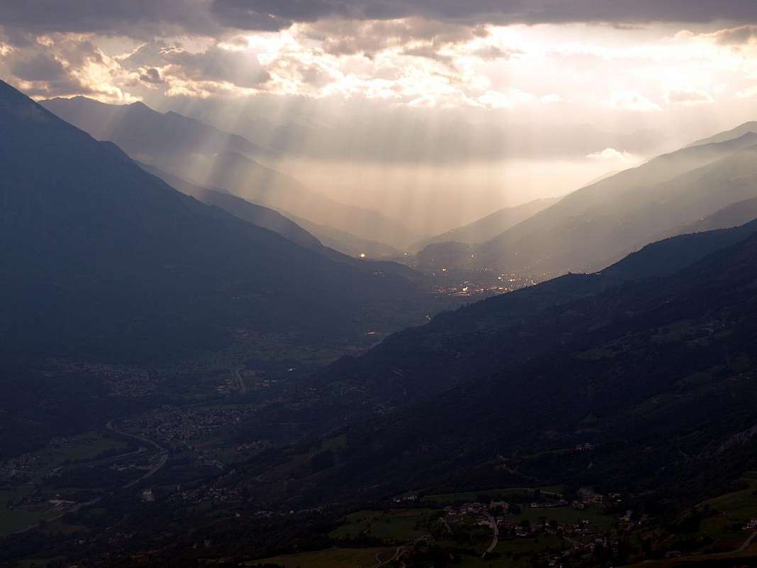
![]()
Aosta Town from neighboring St. Evence Summit, by Osw
BY PLANE:
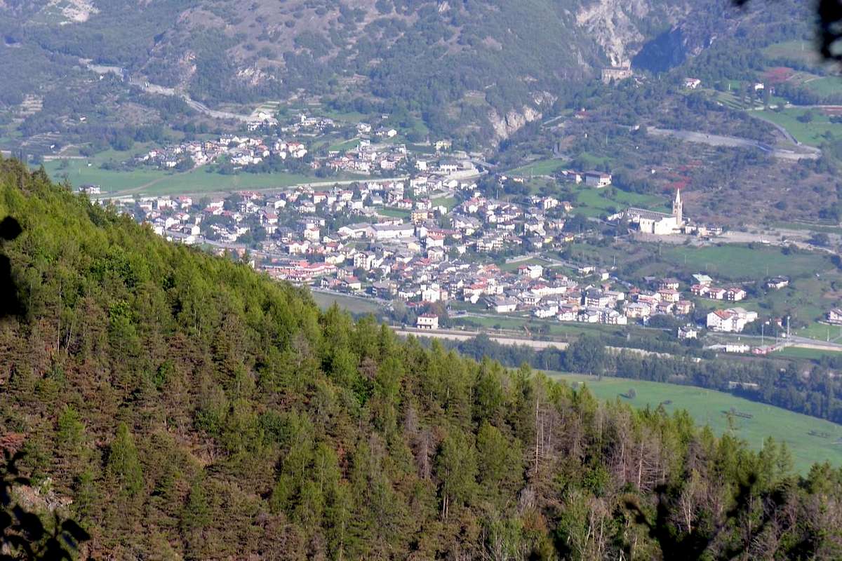
![]()
St. Denis Area below St. Evence & above Châtillon, by Osw
Route A (In the Verrayes/St. Denis Basin with departure by the Villages of Semon, Plau or Del)
1) - Starting from Semon (1.359m) or Plau (1.305m) with private dirt road up to the Hostel Nature of Lavesé (1.500m) and then on path n° 2 or directly from one of Plau always and completely with trail n° 2, reaching the Chapel St. Evence and its crossing on the watershed with Torgnon to Colle St. Pantaleon; down from this through the path n° 1, which starts from the homonymous Chapel reaches Semon and Plau tiny Hamlets and then continue to the below Village Sessina (781 m), at the beautiful Castle of Cly.
2) - Or, wanting a little stretch of the route, dall'attiguo Del (1.260m) and from these go up the hill immediately making the circular path as in the first case above described.
Route B (Through St. Pantaleon Hill from St. Denis or by Torgnon Communes)
3) - Starting from the hill start crossing the watershed and, immediately below and the Chapel of the same name (1.640/5 meters; panel to start and reports in yellow) to proceed with continuous and short ups and downs through the trail n° 2, reaching the Chapel of St. Evence and this fall, always with the path numbered 2 to Semon and then up through the same (logical continuation of the path n° 1, that comes from that of Bedeugaz in the valley floor, at the Chambave Common) towards the St. Pantaleon Hill.
4) - Now down the hill towards the Villages of Semon (1.359m) and Plau (1.305m) and then reach the chapel and reverse path crossing on watershed with Valtournanche.
Route C (By Torgnon with diagonal trail on East Face)
5) - Torgnon also by Antey St. André passing through Petit Berzin Village on Eastern Slope: it is also possible to walk along the Eastern slope with two distinct departures:
a) - from Antey St. André Municipality in Low Valtournanche Valley, locations Grand Moulin (1.038m), go up with the Municipal Road towards the Southwest progressively reaching the Villages of Navillod (1.146m), Villettaz, Petit Berzin and Berzin (1.196m, 1.161m), where the same in asphalt he ends. From here the route n° 14 which, via a long diagonal between the "Bois de Chessin, Bois de Berzi" and crossing the "Comba de l'Enfer" or "Hell Basin" on the Eastern Slope, goes to join after the Alpage Praz de Tard (1.308m) to the path n° 2 that comes from the other side, or Verrayes/St. Denis Basin, with which it concludes towards the Chapel of Saint Evence (E/F; 1h'45/2h'00).
b) - Otherwise start Torgnon, at the Village adjacent to Mognod (1.522m), through the Municipal Road always towards Berzin but passing through the Villages Valleil (1.359m), Champagnod (1.333/44m), junction before Chesod (1.307m) and next at altitude 1.269 meters reaching Pt. Berzin and Berzin. So always with the same itinerary n° 14; from the latter to cross 1.565/70 meters with the trail n° 2 from San Pantaleon Hill and Villages Del, Plau, Semon (E/F; 1h'15/1h'30 from Berzin; 2h'30/2h'45 by Torgnon-Mognod).
![]()
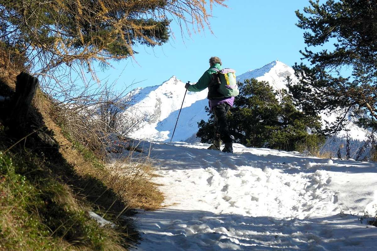
Torgnon towards Col des Bornes by snowshoes, by Osw
Route D (By Torgnon before passing on Col des Bornes with trail even for the MTB)
6) - Directly from Torgnon with tour "more large": by Torgnon Municipality, Fraction Septumian (1547m), or through the locations of Pecou (1.618m) and Chatrian (1.650m) go up through a little asphalt road towards the crossroads 1.715 meters at the Farmhouse "Les 4 Saisons", whence the junction 1.747 meters at the small Village of Goletta (1.770m). Continue South-southwest until Proz Rion or Plan Prorion little Village with small area where ends the road in asphalt (1.772m; "Picnic Area" and small field of Football). From here through the path n° 1 to the Southwest concomitant with the private dirt road to the interior of the Forests "Bois de Ronc, Bois de Pointy" to the Col des Bornes (1.781m), with great views of the Matterhorn, near the mountain pasture of the same name already in the Basin of Verrayes / St. Denis (1.725m; T; 1h'00/h'15 from Goletta), below the Eastern Slope of Becca d'Aver (2.469m). From the hill to move towards the Southeast through the path-mule track n° 4 that, coming and going through the Forest "Bois du Col St. Pantaléon" with a short ascent, flexes more to the East reaching the Regional Road just before the Col Saint Pantaleon (1.650m; T/F; 0h'30/0h'45; up the hill 2h'00/2h'15. By this means the routes before the Chapel of St. Evence (total from Torgnon Torgnon E/F; 5h'00/5h'30; by snowshoes even EE/F+; 7h'00/7h'30). This route, as well as skiing and snowshoeing, is also carried out with mountain bikes.
Route E (From valley floor by the "Chameran" locality neighboring Châtillon Commune)
7) - Châtillon around with "longer route" starting from the place called "Chameran" (football field) of Châtillon to 560 meters near the roundabout (with boulder depicting the Matterhorn) at the beginning of the road that goes up the Valtournanche Valley. It climbs through the houses encountering a first report to the trail n° 4 to the Village of Semon. The same continues Eastward with beautiful views over the course of Baltea reached not long after the "Ru Chandianaz" to 900 meters around. From this and turning to the left you continue crossing a old landslide, immediately beyond which begins a private dirt road. Browse to the location of the path next to the Northwest in the woods at an altitude of 900 meters about you get to a stone quarry where still work equipment. Reached a plateau panoramic (illustrative panels and reports) at the end of the trail continues through the road that goes West to the Village of Grand Bruson (1.139m; fountain and oven); from here you get to Moral small Hamlet (1.140m) and the road to the Northwest, after about 100 meters you'll find on an altitude of 1.200 meters about the road that then becomes a mule track in altitude of 1.170 meters around; with fairly steep path we return in the forest before crossing a dirt road and arriving to a second in about 1.320/5 meters of altitude. From this point there are two possibilities of ascent:
c) - Again with the path to reach the Northwest Village of Plau (1.305m) to the East of the Del and below that of Semon (1.359m), where the preceding path n° 2.
d) - Through an alternative route more to the East, evident and shorter but not reported, Eastward is still first on the farms private dirt road to a height of about 1.330/40 meters and through the path with wide turns in the beautiful Chérisoulaz Forest to the North-northeast towards the junction 1.565/70 meters around meeting the reports to the left for Saint Evence, which is reached by tighter and small hairpin bends. Beyond the junction, where it crosses the route n° 14 from Berzin below small Village, and then go up to the North with several guards the headland to the large grassy esplanade final with the white Chapel in longitudinal East/West axis disposed (E/F; 3h'30/4h'00).
![]()
Torgnon Common from neighboring St. Pantaleon Hill at the beginning of the route, by Osw
Via A (Nella Conca Verrayes/St. Denis con partenze dai Villaggi di Semon, Plau o Del)
Ma chi eran St. Pantaleon, al quale é stato dedicato il Colle nonché la Cappella appena sotto, e St. Denis dal quale riceve il nome il Comune sottostante?
Ritorniamo a quanto appena esposto, facendo osservare che nella "Storia dei Santi" troviamo un pò dell'uno ed un poco dell'altro ma, soprattutto, evidenziando come la tradizione Occidentale deriva da quella Orientale e che in quest'ultima i confini tra storia e leggenda sono alquanto labili e sfumati. Questo vale sia per St. Théodule, St. Pantaleon che per St. Denis che, come Julien, Porciero e Besso, non sono Santi nati e cresciuti nella molto religiosa Valle di Aosta, bensì importati. Anche in qualche caso nonostante il loro appellativo sia stato francesizzato. Così da questa famosa "Legione Tebea" che, a quanto pare, produceva più Santi che legionari sono arrivati tutti questi Santi & Eremiti, tra i quali si "salvano" sicuramente St. Emeric nato e cresciuto al Villair de Quart e poi Vescovo di Aosta. Nonché il "greco" St. Pantaleon venerato in quasi tutta Europa e che in Valle risulta protettore dei Comuni di Chamois e Valpelline e del quale si trovano cappelle sparse su tutto il territorio (Gimillan, Erèsaz presso Emarese ed al colle omonimo). Pantaleone, o anche Pantaleo ed in greco Panteleimon é nato a Nicomedia nel 275 dopo Cristo e qui morto il 27 luglio 305), è stato un antico santo greco. Cristiano e medico personale del Cesare Galerio subì il martirio durante le persecuzioni di Diocleziano. Viene considerato, con i Santi Cosma e Damiano, come Santo Patrono dei medici e delle ostetriche, e risulta venerato come tale da numerose Chiese Cristiane un pò in tutta Europa. Pantaleone è oggetto di venerazione in tutto lo Oriente, dove viene chiamato "il grande Martire" ed è invocato come taumaturgo. Sul monte Athos, Grecia, il monastero della comunità russa, uno dei venti ancora oggi esistenti sulla santa montagna, è a lui dedicato (Monastero di San Panteleimon). le sue reliquie del santo si trovano nella basilica di Saint-Denis a Parigi e altre nella città di Porto in Portogallo. Saint Denis de Lutèce (Italia, III° Secolo – Parigi, III° Secolo) é stato il primo Vescovo di Parigi, originario dal limitrofo Comune di St. Denis e venerato come santo dalla Chiesa Cattolica e quindi primo vescovo della capitale della Francia. La Chiesa cattolica lo venera come santo, martire e patrono di Parigi e della Seine-Saint-Denis. Morì martire verso il 250 o il 270 dopo Cristo e sul luogo dove fu sepolto furono erette dapprima la Basilica e poi, sopra la stessa, l'Abbazia o "Abbuy"di Saint Denis. Il piccolo edificio religioso, con il suo campanile, è visibile da diversi comuni della Valle di Aosta. Qui dobbiamo documentare quindi una "più moderna connection" tra il culto religioso tra Francia e Val d'Aosta senza dovere ricorrere, come per St. Evence, St. Théodule, St. Julien, San Besso e San Porciero, alla solita Leggenda della Legione Tebea.
Getting There
BY CAR:- From TORINO, MILANO, etc: Motorway A5. Exit at IVREA or Quincinetto (PIEDMONT).
- From IVREA Town: in West towards Pont St. Martin, Donnas, Arnad, Verrès, Bard, St. Vincent, Châtillon, Chambave, Nus, Verrayes, St. Denis Municipalities in the Central Valley of Dora Baltea also from Châtillon towards Antey - St. André and Torgnon Communes in Valtournanche.
- From Courmayeur Resort: in East to Morgex, La Salle, St. Pierre, Aosta, Nus, Chambave, Verrayes, St. Denis also towards Châtillon, Antey - St. André and Torgnon.
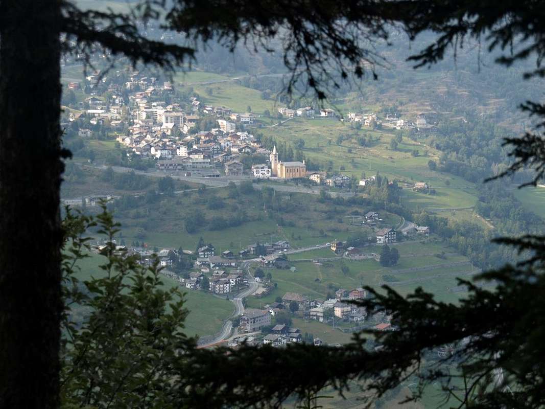
![]()
Nus Common just before Chambave, by emilius - From Aosta Town towards St. Christophe, Quart, Nus, Chambave, Châtillon and Torgnon Municipalities: From SS.26, nearby Chambave, to Regional Road; towards Ollières, Marseiller (801m) to Verrayes (991m). With Municipal Road towards Tessellaz, Marquis, Dorinaz (1.323m), Charrière Villages to Grand-Villa Hamlet (1.423m), in Verrayes/Saint Denis Basin and to Aver-Longhede Area.
- From A) - Verrayes, with Regional Road, towards Del (1.260m), Plau (1.305m), Semon to Cheresoulaz (1.487m) Villages. Also from B) - Saint Denis (803m; reached from Chambave, Marseiller) with Regional Road towards Gubioche, Etrobleyaz, Petit Bruson, to Del Villages. C*** Road Connection towards Roves, Lozon (1.520m), Clavon, Fontane Villages, Pastures to Bornes Alp). From Cheresoulaz, through Municipal/Regional Roads, to Saint Pantaléon Hill (1.650m).
- From Châtillon (549m), with Regional Road of the Valtournanche towards Antey - St. André and Torgnon (1.080m, 1.489m) Municipalities ; from this last, through Regional Road in South-southwest, to Pantaleon Hill (1.650m), amongst Becca d'Avèr, Col des Bornes and "Tour de Saint Evence".
![]()
Cly Castle in St.-Denis Common, by R. Ferronato - From FRANCE: through the Mont Blanc Tunnel to Entrèves-crossroads to Vény/Ferret Valleys - Mountain Guides of Courmayeur - La Saxe Rock Gym - Courmayeur. By Little Saint Bernard Pass, closed since November until half May to La Thuile Valley - Pré Saint Didier - Courmayeur. It is not necessary to take Motorway A5: you can drive on SS.26, in the direction of AOSTA - IVREA - TURIN.
BY PLANE:
- Aeroporto "Corrado Gex" Saint Christophe (Aosta).
Routes Description
Route A (In the Verrayes/St. Denis Basin with departure by the Villages of Semon, Plau or Del)
1) - Starting from Semon (1.359m) or Plau (1.305m) with private dirt road up to the Hostel Nature of Lavesé (1.500m) and then on path n° 2 or directly from one of Plau always and completely with trail n° 2, reaching the Chapel St. Evence and its crossing on the watershed with Torgnon to Colle St. Pantaleon; down from this through the path n° 1, which starts from the homonymous Chapel reaches Semon and Plau tiny Hamlets and then continue to the below Village Sessina (781 m), at the beautiful Castle of Cly.
2) - Or, wanting a little stretch of the route, dall'attiguo Del (1.260m) and from these go up the hill immediately making the circular path as in the first case above described.
Route B (Through St. Pantaleon Hill from St. Denis or by Torgnon Communes)
3) - Starting from the hill start crossing the watershed and, immediately below and the Chapel of the same name (1.640/5 meters; panel to start and reports in yellow) to proceed with continuous and short ups and downs through the trail n° 2, reaching the Chapel of St. Evence and this fall, always with the path numbered 2 to Semon and then up through the same (logical continuation of the path n° 1, that comes from that of Bedeugaz in the valley floor, at the Chambave Common) towards the St. Pantaleon Hill.
4) - Now down the hill towards the Villages of Semon (1.359m) and Plau (1.305m) and then reach the chapel and reverse path crossing on watershed with Valtournanche.
Route C (By Torgnon with diagonal trail on East Face)
5) - Torgnon also by Antey St. André passing through Petit Berzin Village on Eastern Slope: it is also possible to walk along the Eastern slope with two distinct departures:
a) - from Antey St. André Municipality in Low Valtournanche Valley, locations Grand Moulin (1.038m), go up with the Municipal Road towards the Southwest progressively reaching the Villages of Navillod (1.146m), Villettaz, Petit Berzin and Berzin (1.196m, 1.161m), where the same in asphalt he ends. From here the route n° 14 which, via a long diagonal between the "Bois de Chessin, Bois de Berzi" and crossing the "Comba de l'Enfer" or "Hell Basin" on the Eastern Slope, goes to join after the Alpage Praz de Tard (1.308m) to the path n° 2 that comes from the other side, or Verrayes/St. Denis Basin, with which it concludes towards the Chapel of Saint Evence (E/F; 1h'45/2h'00).
b) - Otherwise start Torgnon, at the Village adjacent to Mognod (1.522m), through the Municipal Road always towards Berzin but passing through the Villages Valleil (1.359m), Champagnod (1.333/44m), junction before Chesod (1.307m) and next at altitude 1.269 meters reaching Pt. Berzin and Berzin. So always with the same itinerary n° 14; from the latter to cross 1.565/70 meters with the trail n° 2 from San Pantaleon Hill and Villages Del, Plau, Semon (E/F; 1h'15/1h'30 from Berzin; 2h'30/2h'45 by Torgnon-Mognod).
Route D (By Torgnon before passing on Col des Bornes with trail even for the MTB)
6) - Directly from Torgnon with tour "more large": by Torgnon Municipality, Fraction Septumian (1547m), or through the locations of Pecou (1.618m) and Chatrian (1.650m) go up through a little asphalt road towards the crossroads 1.715 meters at the Farmhouse "Les 4 Saisons", whence the junction 1.747 meters at the small Village of Goletta (1.770m). Continue South-southwest until Proz Rion or Plan Prorion little Village with small area where ends the road in asphalt (1.772m; "Picnic Area" and small field of Football). From here through the path n° 1 to the Southwest concomitant with the private dirt road to the interior of the Forests "Bois de Ronc, Bois de Pointy" to the Col des Bornes (1.781m), with great views of the Matterhorn, near the mountain pasture of the same name already in the Basin of Verrayes / St. Denis (1.725m; T; 1h'00/h'15 from Goletta), below the Eastern Slope of Becca d'Aver (2.469m). From the hill to move towards the Southeast through the path-mule track n° 4 that, coming and going through the Forest "Bois du Col St. Pantaléon" with a short ascent, flexes more to the East reaching the Regional Road just before the Col Saint Pantaleon (1.650m; T/F; 0h'30/0h'45; up the hill 2h'00/2h'15. By this means the routes before the Chapel of St. Evence (total from Torgnon Torgnon E/F; 5h'00/5h'30; by snowshoes even EE/F+; 7h'00/7h'30). This route, as well as skiing and snowshoeing, is also carried out with mountain bikes.
Route E (From valley floor by the "Chameran" locality neighboring Châtillon Commune)
7) - Châtillon around with "longer route" starting from the place called "Chameran" (football field) of Châtillon to 560 meters near the roundabout (with boulder depicting the Matterhorn) at the beginning of the road that goes up the Valtournanche Valley. It climbs through the houses encountering a first report to the trail n° 4 to the Village of Semon. The same continues Eastward with beautiful views over the course of Baltea reached not long after the "Ru Chandianaz" to 900 meters around. From this and turning to the left you continue crossing a old landslide, immediately beyond which begins a private dirt road. Browse to the location of the path next to the Northwest in the woods at an altitude of 900 meters about you get to a stone quarry where still work equipment. Reached a plateau panoramic (illustrative panels and reports) at the end of the trail continues through the road that goes West to the Village of Grand Bruson (1.139m; fountain and oven); from here you get to Moral small Hamlet (1.140m) and the road to the Northwest, after about 100 meters you'll find on an altitude of 1.200 meters about the road that then becomes a mule track in altitude of 1.170 meters around; with fairly steep path we return in the forest before crossing a dirt road and arriving to a second in about 1.320/5 meters of altitude. From this point there are two possibilities of ascent:
c) - Again with the path to reach the Northwest Village of Plau (1.305m) to the East of the Del and below that of Semon (1.359m), where the preceding path n° 2.
d) - Through an alternative route more to the East, evident and shorter but not reported, Eastward is still first on the farms private dirt road to a height of about 1.330/40 meters and through the path with wide turns in the beautiful Chérisoulaz Forest to the North-northeast towards the junction 1.565/70 meters around meeting the reports to the left for Saint Evence, which is reached by tighter and small hairpin bends. Beyond the junction, where it crosses the route n° 14 from Berzin below small Village, and then go up to the North with several guards the headland to the large grassy esplanade final with the white Chapel in longitudinal East/West axis disposed (E/F; 3h'30/4h'00).
Via A (Nella Conca Verrayes/St. Denis con partenze dai Villaggi di Semon, Plau o Del)
1) - Iniziando da Semon (1.359 m) o Plau (1.305 m) con poderale fino allo Ostello Ecosostenibile di Lavesé (1.500 m) per poi inserirsi sul sentiero n° 2, oppure direttamente da quello di Plau sempre e completamente con sentiero n° 2, raggiungendo la Cappella di St. Evence e relativa traversata sullo spartiacque con Torgnon fino al Colle St. Pantaleon; discesa da questo tramite il sentiero n° 1, che partendo dall'omonima Cappella raggiunge Semon e Plau ed indi continuare fino al Villaggio Sessina (781 m), al Castello di Cly.
2) - Oppure, volendo allungare d'un poco il percorso, dall'attiguo di Del (1.260 m) e da questi salire subito al colle compiendo il percorso circolare come nel primo sovradescritto.
Via B (Dal Colle San Pantaleon partendo dai Comuni di St. Denis oppure da Torgnon)
3) - Partendo dal colle iniziare la traversata sullo spartiacque e, subito dalla sottostante ed omonima Cappella (1.640/5 metri circa; pannello illustrativo dell'intero percorso all'inizio), con segnalazioni in giallo n° 2 dietro la stessa e verso sinistra (attenzione il sentiero a destra scende) procedere con continui e brevi saliscendi tramite il sentiero n° 2 raggiungendo la Cappella di St. Evence, sita in un grande spiazzo erboso al limitar del bosco. Scendere, sempre con sentiero numerato 2 verso il Villaggio di Semon per poi risalire per mezzo del medesimo (logica continuazione del sentiero n° 1 che arriva da quello di Bedeugaz nel fondovalle, presso il Comune di Chambave) al Colle St. Pantaleon.
4) - Scendere subito dal colle verso i Villaggi di Semon (1.359 m) e Plau (1.305 m); indi raggiungere la Cappella e con percorso inverso attraversare lo spartiacque con Torgnon.
Via C (Da Torgnon oppure da Antey St. André per il Villaggio di Pt. Berzin con via diagonale sulla Faccia Est)
5) - Da Torgnon o da Antey Saint André passando per Berzin sul Versante Orientale. Inoltre é possibile percorrere il Versante Orientale con due partenze ben distinte:
a) - da Antey St. André, località Grand Moulin (1.038 m) salire con la Municipale verso Sudovest raggiungendo i Villaggi di Navillod (1.146 m), Villettaz, Petit Berzin e Berzin (1.196 m, 1.161 m), dove la stessa termina. Da qui parte il sentiero n° 14 che, tramite lungo diagonale tra i "Bois de Chessin, Bois de Berzì" ed attraversando la "Comba de l'Enfer" sul Versante Orientale, va a congiungersi dopo l'Alpe Praz de Tard (1.308 m) al sentiero n° 2 proveniente dall'altro versante (St. Denis) col quale si conclude (E/F; 1h'45/2h'00).
b) - Altrimenti variando la partenza dal Comune di Torgnon, presso il Villaggetto attiguo di Mognod (1.522 m), tramite la Strada Municipale sempre verso Berzin ma passando con un giro semicircolare per i Villaggi di Valleil (1.359 m), Champagnod (1.333/44 m), bivio prima di Chesod (1.307 m) e successivo in quota 1.269 metri, raggiungendo in successione i Villaggi di Petit Berzin e Berzin (1.161 m). Quindi da questo punto di partenza a piedi procedere sempre col medesimo itinerario n° 14; da quest'ultimo all'incrocio 1.565/70 metri circa col sentiero n° 2 proveniente dal Colle San Pantaleon e da Del, Plau e Semon (E/F; 1h'15/1h'30 da Berzin; 2h'30/2h'45 da Torgnon-Mognod).
Via D (Da Torgnon passando prima al Col des Bornes con percorso anche per MTB)
6) - Direttamente da Torgnon con tour "più largo": da Torgnon Frazione di Septumian (1.547 m) oppure dalle località di Pecou (1.618 m) e Chatrian (1.650 m) risalire verso il bivio 1.715 metri presso lo Agriturismo "Les 4 Saisons" donde al bivio 1.747 metri presso il Villaggetto di Golette (1.770 m); continuare fino a Proz Rion o Plan Prorion con piccolo comprensorio dove termina la strada in asfalto (1.772 m; Area Pic Nic e campetto di calcio). Da qui tramite il sentiero n° 1 verso Sudovest concomitante con la poderale allo interno delle Foreste "Bois de Ronc e Bois de Pointy" fino al Col des Bornes, con grande vista sul Cervino, presso lo omonimo alpeggio ormai nel bacino di Verrayes/St. Denis (1.725 m; T; 1h'00/1h'15 da Golette), sotto il Versante Orientale della Becca d'Aver (2.469 m). Dal colle indirizzarsi verso Sudest tramite il sentiero-mulattiera n° 4 che, rientrando ed attraversando la Foresta "Bois du Col Saint Pantaléon" con breve risalita, flette più ad Est raggiungendo la Strada Regionale appena prima del Col San Pantaleon (1.650 m; T/F; 0h'30/0h'45; fino al colle 2h'00/2h'15). Da questo tramite gli itinerari precedenti alla Cappella di Saint Evence (complessivamente da Torgnon a Torgnon E/F; 5h'00/5h'30; con racchette da neve anche EE/F+; 7h'00/7h'30). Questo percorso, oltre che con gli sci e le racchette da neve, viene effettuato anche con le mountain bikes.
Via E (Dal fondovalle presso la località di "Chameran" a Châtillon)
7) - Da Châtillon con giro "più lungo" partendo dalla località detta "Chameran" (campo di calcio) di Chatillon a 560 metri circa nei pressi della rotonda (con masso che raffigura il Monte Cervino) all’inizio della strada che risale la Valtournanche Cervino. Si risale in mezzo alle case incontrando una prima segnalazione per il sentiero n° 4 verso il Villaggio di Semon. Lo stesso continua verso Oriente con belle vedute sopra il corso della Dora Baltea raggiungendo non molto tempo dopo il Ru Chandianaz verso i 900 metri circa; da questo e girando verso sinistra si continua attraversando un vecchia frana, subito oltre la quale inizia una strada poderale. Individuato il percorso successivo del sentiero verso Nordovest nel bosco alla quota di 900 metri circa si arriva ad una cava di pietra dove permangono attrezzature di lavoro. Raggiunto un pianoro panoramico (pannelli illustrativi e segnalazioni) al termine del sentiero si continua tramite la strada che sale ad Ovest verso il Villaggio di Grand Bruson (1.139 m; fontana e forno); da qui si raggiunge quello di Moral (1.140 m) e con la strada a Nordovest, dopo un circa 100 metri si incontra a quota 1.200 metri circa la strada che poi diventa mulattiera 1.170m; con percorso abbastanza ripido si ritorna nella foresta attraversando una prima poderale ed arrivando ad una seconda in altitudine di 1.320/5 metri circa. Da questo punto esistono due possibilità:
c) - Sempre con percorso a Nordovest raggiungere il Villaggio di Plau (1.305 m) ad Oriente di quello di Del e sotto a quello di Semon (1.359 m), dove parte il sentiero n° 2.
d) - In alternativa, più corta ma non segnalata, si continua ad Oriente dapprima sulla poderale fino a quota 1.330/40 metri circa e con il sentiero con larghi tornanti verso Nord-nordest nel bosco sino al bivio 1.565/70 metri circa incontrando le segnalazioni verso sinistra per St. Evence, che si raggiunge con più stretti e piccoli tornanti. Oltre il bivio, dove si incrocia il sentiero n° 14 da Berzin, e quindi verso Settentrione si risale con diverse protezioni il promontorio verso la larga spianata erbosa finale (E/F; 3h'30/4h'00).
From St. Pantaleon Hill (1.650m) towards the homonym Chapel & St. Evence Promontory (1.767m) with Area & Chapel (1.750m), by Osw 2015
2) - Oppure, volendo allungare d'un poco il percorso, dall'attiguo di Del (1.260 m) e da questi salire subito al colle compiendo il percorso circolare come nel primo sovradescritto.
Via B (Dal Colle San Pantaleon partendo dai Comuni di St. Denis oppure da Torgnon)
3) - Partendo dal colle iniziare la traversata sullo spartiacque e, subito dalla sottostante ed omonima Cappella (1.640/5 metri circa; pannello illustrativo dell'intero percorso all'inizio), con segnalazioni in giallo n° 2 dietro la stessa e verso sinistra (attenzione il sentiero a destra scende) procedere con continui e brevi saliscendi tramite il sentiero n° 2 raggiungendo la Cappella di St. Evence, sita in un grande spiazzo erboso al limitar del bosco. Scendere, sempre con sentiero numerato 2 verso il Villaggio di Semon per poi risalire per mezzo del medesimo (logica continuazione del sentiero n° 1 che arriva da quello di Bedeugaz nel fondovalle, presso il Comune di Chambave) al Colle St. Pantaleon.
4) - Scendere subito dal colle verso i Villaggi di Semon (1.359 m) e Plau (1.305 m); indi raggiungere la Cappella e con percorso inverso attraversare lo spartiacque con Torgnon.
Via C (Da Torgnon oppure da Antey St. André per il Villaggio di Pt. Berzin con via diagonale sulla Faccia Est)
5) - Da Torgnon o da Antey Saint André passando per Berzin sul Versante Orientale. Inoltre é possibile percorrere il Versante Orientale con due partenze ben distinte:
a) - da Antey St. André, località Grand Moulin (1.038 m) salire con la Municipale verso Sudovest raggiungendo i Villaggi di Navillod (1.146 m), Villettaz, Petit Berzin e Berzin (1.196 m, 1.161 m), dove la stessa termina. Da qui parte il sentiero n° 14 che, tramite lungo diagonale tra i "Bois de Chessin, Bois de Berzì" ed attraversando la "Comba de l'Enfer" sul Versante Orientale, va a congiungersi dopo l'Alpe Praz de Tard (1.308 m) al sentiero n° 2 proveniente dall'altro versante (St. Denis) col quale si conclude (E/F; 1h'45/2h'00).
b) - Altrimenti variando la partenza dal Comune di Torgnon, presso il Villaggetto attiguo di Mognod (1.522 m), tramite la Strada Municipale sempre verso Berzin ma passando con un giro semicircolare per i Villaggi di Valleil (1.359 m), Champagnod (1.333/44 m), bivio prima di Chesod (1.307 m) e successivo in quota 1.269 metri, raggiungendo in successione i Villaggi di Petit Berzin e Berzin (1.161 m). Quindi da questo punto di partenza a piedi procedere sempre col medesimo itinerario n° 14; da quest'ultimo all'incrocio 1.565/70 metri circa col sentiero n° 2 proveniente dal Colle San Pantaleon e da Del, Plau e Semon (E/F; 1h'15/1h'30 da Berzin; 2h'30/2h'45 da Torgnon-Mognod).
Via D (Da Torgnon passando prima al Col des Bornes con percorso anche per MTB)
6) - Direttamente da Torgnon con tour "più largo": da Torgnon Frazione di Septumian (1.547 m) oppure dalle località di Pecou (1.618 m) e Chatrian (1.650 m) risalire verso il bivio 1.715 metri presso lo Agriturismo "Les 4 Saisons" donde al bivio 1.747 metri presso il Villaggetto di Golette (1.770 m); continuare fino a Proz Rion o Plan Prorion con piccolo comprensorio dove termina la strada in asfalto (1.772 m; Area Pic Nic e campetto di calcio). Da qui tramite il sentiero n° 1 verso Sudovest concomitante con la poderale allo interno delle Foreste "Bois de Ronc e Bois de Pointy" fino al Col des Bornes, con grande vista sul Cervino, presso lo omonimo alpeggio ormai nel bacino di Verrayes/St. Denis (1.725 m; T; 1h'00/1h'15 da Golette), sotto il Versante Orientale della Becca d'Aver (2.469 m). Dal colle indirizzarsi verso Sudest tramite il sentiero-mulattiera n° 4 che, rientrando ed attraversando la Foresta "Bois du Col Saint Pantaléon" con breve risalita, flette più ad Est raggiungendo la Strada Regionale appena prima del Col San Pantaleon (1.650 m; T/F; 0h'30/0h'45; fino al colle 2h'00/2h'15). Da questo tramite gli itinerari precedenti alla Cappella di Saint Evence (complessivamente da Torgnon a Torgnon E/F; 5h'00/5h'30; con racchette da neve anche EE/F+; 7h'00/7h'30). Questo percorso, oltre che con gli sci e le racchette da neve, viene effettuato anche con le mountain bikes.
Via E (Dal fondovalle presso la località di "Chameran" a Châtillon)
7) - Da Châtillon con giro "più lungo" partendo dalla località detta "Chameran" (campo di calcio) di Chatillon a 560 metri circa nei pressi della rotonda (con masso che raffigura il Monte Cervino) all’inizio della strada che risale la Valtournanche Cervino. Si risale in mezzo alle case incontrando una prima segnalazione per il sentiero n° 4 verso il Villaggio di Semon. Lo stesso continua verso Oriente con belle vedute sopra il corso della Dora Baltea raggiungendo non molto tempo dopo il Ru Chandianaz verso i 900 metri circa; da questo e girando verso sinistra si continua attraversando un vecchia frana, subito oltre la quale inizia una strada poderale. Individuato il percorso successivo del sentiero verso Nordovest nel bosco alla quota di 900 metri circa si arriva ad una cava di pietra dove permangono attrezzature di lavoro. Raggiunto un pianoro panoramico (pannelli illustrativi e segnalazioni) al termine del sentiero si continua tramite la strada che sale ad Ovest verso il Villaggio di Grand Bruson (1.139 m; fontana e forno); da qui si raggiunge quello di Moral (1.140 m) e con la strada a Nordovest, dopo un circa 100 metri si incontra a quota 1.200 metri circa la strada che poi diventa mulattiera 1.170m; con percorso abbastanza ripido si ritorna nella foresta attraversando una prima poderale ed arrivando ad una seconda in altitudine di 1.320/5 metri circa. Da questo punto esistono due possibilità:
c) - Sempre con percorso a Nordovest raggiungere il Villaggio di Plau (1.305 m) ad Oriente di quello di Del e sotto a quello di Semon (1.359 m), dove parte il sentiero n° 2.
d) - In alternativa, più corta ma non segnalata, si continua ad Oriente dapprima sulla poderale fino a quota 1.330/40 metri circa e con il sentiero con larghi tornanti verso Nord-nordest nel bosco sino al bivio 1.565/70 metri circa incontrando le segnalazioni verso sinistra per St. Evence, che si raggiunge con più stretti e piccoli tornanti. Oltre il bivio, dove si incrocia il sentiero n° 14 da Berzin, e quindi verso Settentrione si risale con diverse protezioni il promontorio verso la larga spianata erbosa finale (E/F; 3h'30/4h'00).
 |
 |
 |
 |
 |
Campings
Remember that free camping is forbidden (except for emergency reasons, over 2.500m, from darkness until dawn).Mountain Condition
- Meteo: you can find all the needed informations at the official site of the Valle d'Aosta Region:
- Valle d'Aosta Meteo
Important Information
- REGIONE AUTONOMA VALLE D'AOSTA the official site.
- FONDAZIONE MONTAGNA SICURA Villa Cameron, località Villard de la Palud n° 1 Courmayeur (AO) Tel: 39 0165 897602 - Fax: 39 0165 897647.
- A.I.NE.VA. (Associazione Interregionale Neve e Valanghe).
Useful numbers
- Protezione Civile Valdostana località Aeroporto n° 7/A Saint Christophe (Ao) Tel. 0165-238222.
- Bollettino Meteo (weather info) Tel. 0165-44113.
- Unità Operativa di Soccorso Sanitario Tel. 118.