


-
 2909 Hits
-
 81.18% Score
-
 13 Votes
|
|
Route |
|---|---|
|
|
45.60407°N / 7.49450°E |
|
|
Hiking, Mountaineering |
|
|
Spring, Summer, Fall |
|
|
Half a day |
|
|
Note
|
La montagna chiama i suoi figli, ed essi rispondono fedelmente al suo appello… Osvaldo Cardellina, Diario alpinistico, 1964-65 Page texts: @ OsvaldoCardellina "Osva", passed away on May 2, 2022. Page owners: Christian Cardellina e Osvaldo Cardellina. Any updates from September 12, 2022: Antonio Giani, page administrator, friend and climbing companion. Testi della pagina: @ OsvaldoCardellina "Osva", scomparso il 2 maggio 2022. Proprietari pagina: Christian Cardellina e Osvaldo Cardellina. Eventuali aggiornamenti dal 12 settembre 2022: Antonio Giani, amministratore della pagina, amico e compagno di salite. |
Ponton Tower Northern Overview
The primary objective of this Route from the North is to offer a range of educational ascents aimed at younger or better, the Guys who come to Climbing and want to make their first experience of a "real" Mountain. The support of the Refuge near Sogno di Berdzé facilitates the purpose dividing into two moments of the experience to be lived:
1) - after a brisk walk (which never hurts) from Lillaz Hamlet, reach the refuge along the whole length and wild Vallon Urtier in Cogne Valley. On the opposite side, ie from the Champorcher Valley, you should instead from one of Dondena or by the same name and near the shelter to achieve, in an area full of lakes, the Hills Fénis and immediately after Pontonnet. In both cases you will be able to "pass" a night in a shelter which for many may be the first experience. The second moment is to go up
2) - Ponton Tower easy for one of the routes that we recommend; the same increase of little difficulty progressively starting from the most to the East (* Where there is the way of the first ascent of the mountain, that is of the famous Giovanni Bobba with the Cogne "Mountain Guide" Pietro Perret, 12th September 1897. For the truth is another first ascent, most likely as RM C.A.I. 1917 pag. 116, by the Cogne Abbot Pierre Chanoux in 1849, to substantiate the above, but without specifying the path followed. A classic of those times, where only interested in reaching a Summit still a virgin; see among the various Monte Emilius in 1823, Pic Garin in 1856 and that same year the Lavina Tower. It was more important to state the starting point and sometimes neglected even the name of his companions. But, starting from Cogne, it is easy to understand for the same North-northwest Crest or Bobba Via, also through the Northwest Slope) to get to the most in the West, that ends with an Edge West-northwest, is not difficult if done with workarounds in the North and more interesting if path on the edge of the ridge; in each case the same offers large "escape routes" immediately on the left going up. This is the way most "demanding" side of this large and has several educational opportunities, especially if you walk integrally on the edge, or to start the climb. It is also to be highlighted as the length of the approaches from both valleys has meant that this mountain has been "discovered" much later in time (but the Hunters of His Majesty Vittorio Emanuele II said "The King Hunter" has long organized hunting chamois and ibex in the underlying Hills Fénis, Pontonnet and Champorcher Fenêtre; do not have to hurt the good Bobba, but probably some of these had already been on the Summit. Perhaps even the Italy's King). However, to emphasize what we just said and climbing talking about, you have to wait 13th July 1916 to record another ascension by Amedeo De Gustavo Petro salt for the same route. A time frame that is too large to understand that in the meantime, something else must be verified. In any case, all increases and enhances the appeal of the approach to this mountain, a factor that can help Young People to go over the History ...
![]()
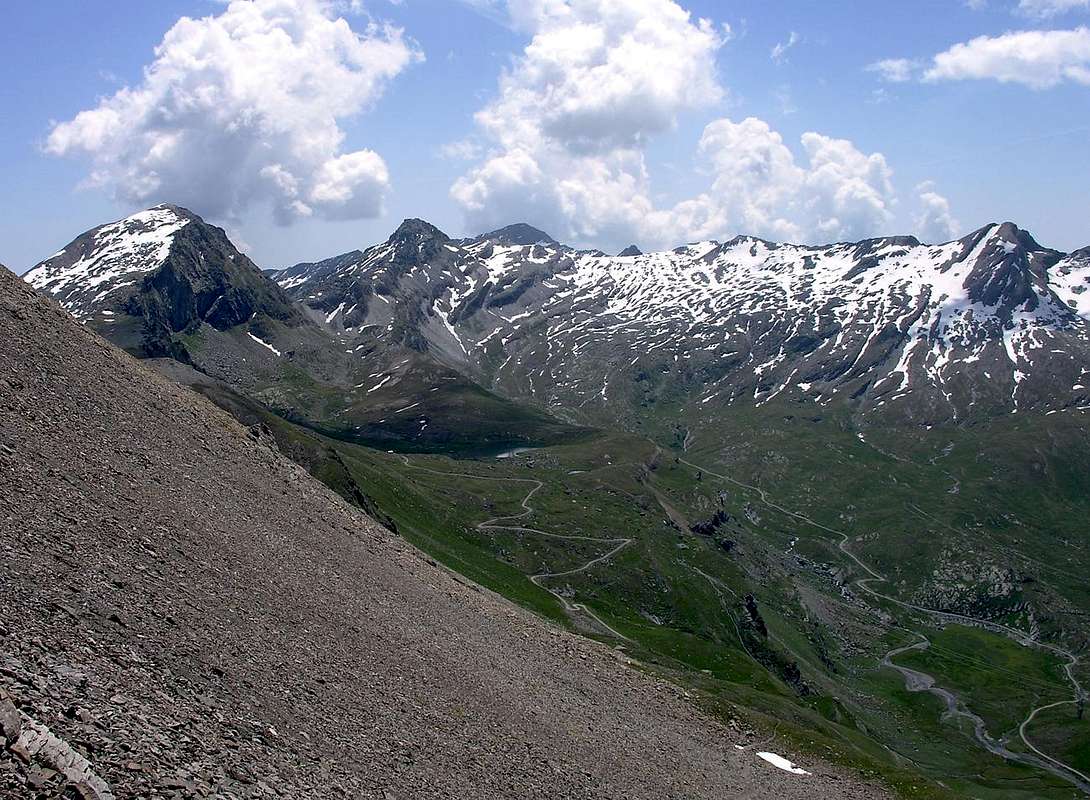
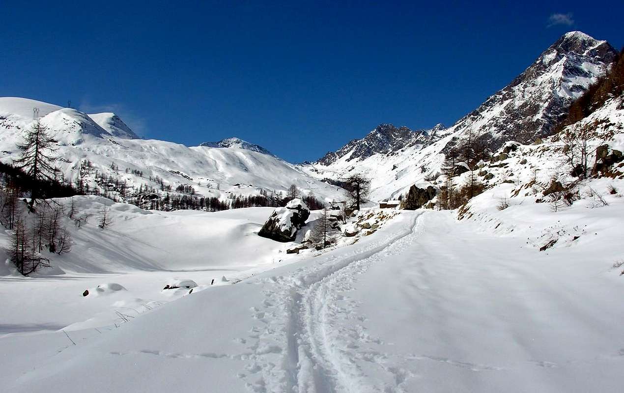
"From Invergneux Pass to Urtier Valley." Left: N Crest & N-NW Slope, W-NW Edge, W and SW Faces & S Ridge to Fenêtre. By Antonio
L'obiettivo primario di questa Route da Settentrione é quello d'offrire una gamma di ascensioni didattiche rivolte ai più giovani o, meglio, ai Ragazzi che s'avvicinano all'Alpinismo e voglion compiere le prime esperienze su di una "vera" Montagna. L'appoggio al vicino Rifugio Sogno di Berdzé facilita lo scopo dividendo in due i momenti dell'esperienza da vivere:
1) - dopo una bella camminata (che non fà mai male) dal Villaggio di Lillaz, raggiungere il rifugio percorrendo l'intero, lungo e selvaggio Vallone dell'Urtier in Valle di Cogne. Sul versante opposto, ovvero dalla Valle di Champorcher, si deve invece partir da quello di Dondena oppure dall'omonimo e viciniore rifugio per raggiungere, in una area ricca di laghi, i Colli di Fénis e subito dopo del Pontonnet. In entrambi i casi si potrà "passare" una notte in un rifugio che per molti può consistere nella prima esperienza. Nel secondo momento si tratta di salire
2) - la facile Torre Ponton per una delle vie che consigliamo; le stesse aumentano di poca difficoltà partendo progressivamente da quelle più ad Oriente (* Ove esiste la via dei primi salitori della montagna, cioé del celebre Giovanni Bobba con la "Guida" di Cogne Pietro Perret, il 12 Settembre 1897. Per la verità risulta un'altra prima salita, più probabile come da RM C.A.I. 1917, pag. 116, da parte dell'Abate di Cogne Pierre Chanoux nel 1849, a suffragio di quant'esposto, ma senza specificarne la via seguita. Un classico di quei tempi, dove interessava esclusivamente il raggiungimento d'una Sommità ancor vergine; vedi tra le varie il Monte Emilius nel 1823, il Pic Garin nel 1856 e nello stesso anno la Torre di Lavina. Era più importante affermare il punto di partenza ed a volte si trascurava persin il nome dei compagni.) per arrivare a quelle più ad Occidente che finiscono con uno Spigolo Ovest-nordovest, non difficile se effettuato con aggiramenti a Nord e più interessante se percorso sul fil di cresta; in ogni caso lo stesso assicura ampie "vie di fuga" subito sulla sinistra salendo. Questa risulta la via più "impegnativa" di quest'ampio versante e presenta varie opportunità didattiche, soprattutto se percorsa integralmente, per l'avviamento all'arrampicata. Inoltre é da evidenziarsi come la lunghezza degli approcci da entrambe le valli ha fatto si che questa montagna sia stata "scoperta" molto tardi nel tempo (ma i Cacciatori di Sua Maestà Vittorio Emanuele II° detto "Il Re Cacciatore" già da molto tempo organizzavano le battute di caccia al camoscio ed allo stambecco nei sottostanti Colli Fénis, Pontonnet e Fenêtre de Champorcher; non ne abbia a male il bravo Bobba, ma probabilmente qualcun di questi sulla Sommità era pur stato. Magari anche il Re d'Italia). Comunque, a sottolinear quanto appena detto ed alpinisticamente parlando, bisogna attendere il 13 Luglio 1916 per registrare un'altra ascensione da parte di Gustavo Amedeo De Petro, solo, per l'identica via. Un lasso troppo esteso tal da far intender che nel frattempo qualcos'altro deve pur essersi verificato. In ogni caso il tutto aumenta e valorizza il fascino per l'avvicinamento a questa montagna, fattore che può aiutare i Giovani a ripassar Storia ...
![]()
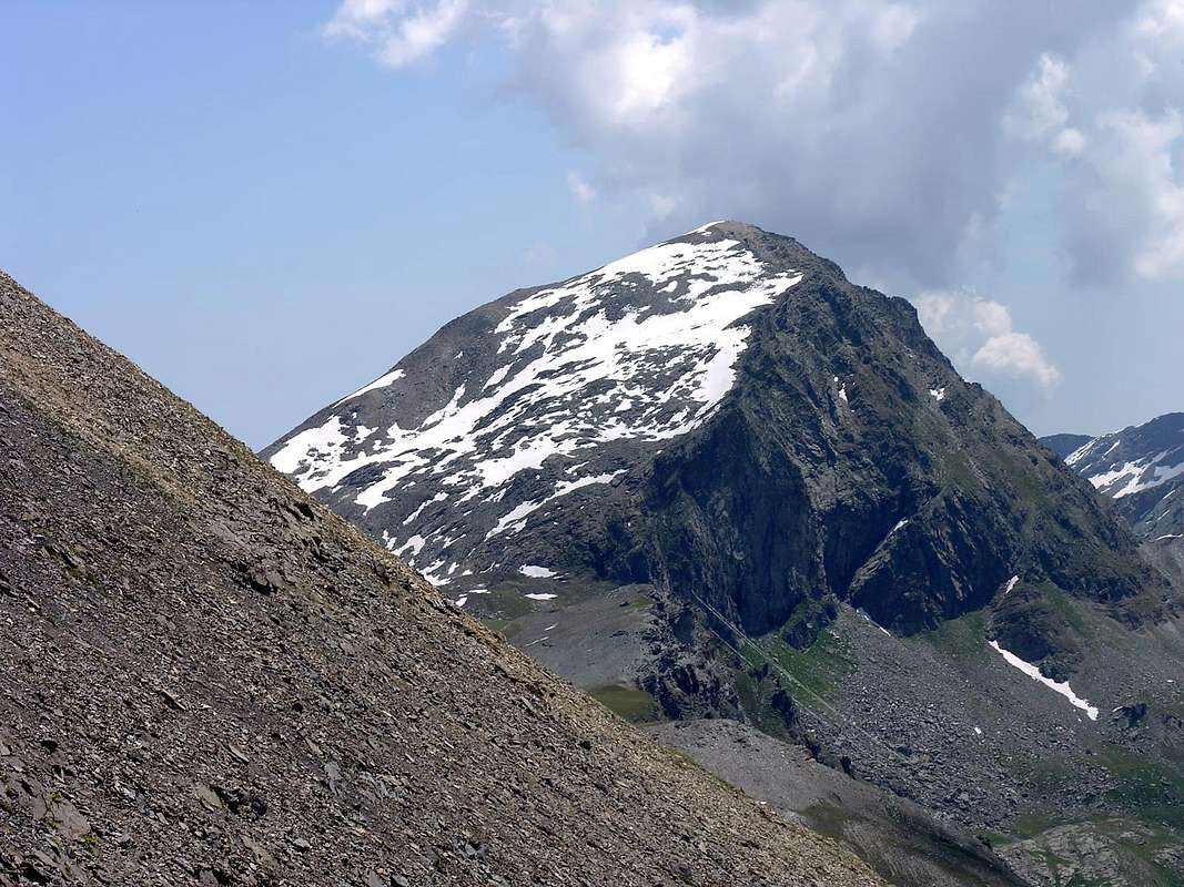
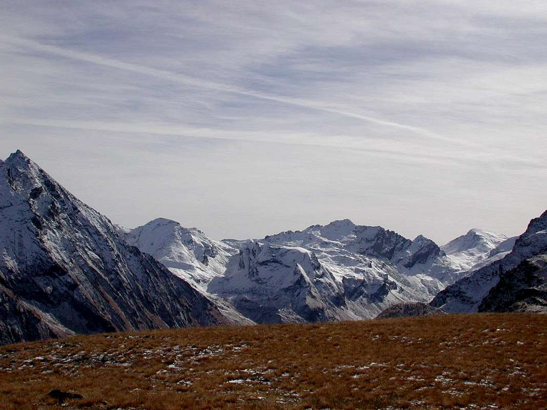
"From Dondena towards Champorcher Valley." Left: E-NE & N-NE Slopes, N-NW Crest to Pontonnet Hill. by Corvus
Getting There
BY CAR:
![]()
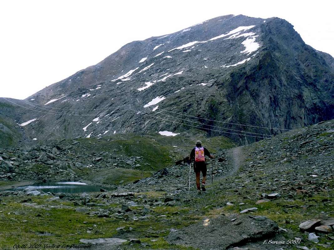
"Summer from Urtier & Winter Dondena Approaches", by livioz and emilius
- From TORINO, MILANO, etc: Motorway A5. Exit at IVREA or Quincinetto (PIEDMONT) also Pont Saint Martin, Verrès, Chatillon, AOSTA East (Nus) and West (Aymavilles) Municipalities (AOSTA Valley).
- From IVREA Town to Hone-Bard, Pont Bozet, Champorcher, Aymavilles.
From Hone-Bard to Champorcher Valley - From Pont Bozet (775m) to Champorcher Valley: Camporcher-Château (1.427m), Petit, Grand Mont Blanc, La Cort Villages, to Dondena Village (2.092m), Dondena & Miserin Refuges, through Royal Road & secondary dirt roads; Barbustel Refuge, through Royal Road, path towards Champdepraz Vallon.
From Aymavilles to Cogne Valley - From Aymavilles (646m) towards Cogne Valley with Regional Main Road: Vieyes (1.132m) Fraction. Continue to Silvenoire, Epinel & Crétaz Hamlets, Cogne (1.534m) Resort, through Main Road. From Lillaz Fraction (1.607m) to Sogno di Berdzé Refuge, by dirt road, muletrack or paths in Urtier Valley. It is not necessary to take Motorway A5: you can drive on SS.26, in the direction of AOSTA - IVREA - TURIN.
"From here the Valley royally domains ... / Da qui regalmente domini la Valle ..." ![]()
- Aeroporto "Corrado Gex" Saint Christophe (Aosta).
Approaches

Approach A (from Cogne Valley through Urtier Valley):
Starting from Cogne Resort (1.534m) you must arrive (bus or car) to the car parking of Lillaz (1.617m). Follow the paths n° 10/13/Haute Route n° 2 with the same also below upaved road, until reach Gollies Upper Pasture (1.869m; *** it is possible to make a small connection between the two routes: a) - go up the path through the vallon floor, more naturalistic, to Alpe Goilles Dèsott (1.831m) and navigate to those above; b) - cover the entire dirt farm road with wide turn to the North, more scenic but no cars). Move on until tiny Church of Crêt or Crest (+ 2.020m; dedicated to the Troops Alpine and home of the ancient and primeval settlement of Cogne; fountain; T/E; 1h'20/1h'35), clearly visible from lowlands. Once gone beyond Tsavanis (2.296m) and Manda Pastures (2.370 m), the shelter is reached (E; 3h'30/3h'45, Lillaz; 2h'00/2h'15 from Crêt).
Coming from Lillaz through Urtier: Tour Ponton, down there, comes out compressed between Punta Tersiva/Tours Pontonnet and Bec Costazza; this side showcases the South Ridge, from Fenetre de Champorcher, the Southwest Face, West Wall and the profile Edge West-northwest. Only in the highest part, flexing further North towards the Pas des Hevergnes, the nearby Ponton and Lakes Pontonnet also showcases the wide Slope Northwest, accompanied on the left by North-northwest Crest also Standard Route.
Avvicinamento A (dalla Val di Cogne per il Vallone dell'Urtier):
Dall'abitato di Cogne (1.534 m) in bus o in auto raggiungere la ridente frazione di Lillaz (1.617 m), dove si parcheggia l'auto nel grande piazzale sito quasi al centro del villaggio. Percorrere i sentieri n° 10/13/Alta Via n°2 con la medesima oppure al disotto della strada poderale fino alle Baite di Gollies di Sopra o Damon (1.869 m; *** risulta possibile effettuare una piccola connessione tra i due itinerari: a) - salire tramite il sentiero sul fondo del Vallone, più naturalistico, fino all'Alpe Goilles Dèsott (1.831 m) ed attraversare a quelle di Sopra; b) - percorrere l'intera strada poderale con largo giro a Settentrione, più panoramico ma vietato alle auto) e continuare fino alla Chiesetta del Crêt o Crest (+ 2.020 m dedicata alle truppe degli Alpini; fontana; sede dell'antico e primordiale insediamento di Cogne; T/E; 1h'20/1h'35), ben visibile dabbasso, e, oltrepassati gli alpeggi di Tsavanis (2.296 m) e Manda (2.370 m), percorrendo un lungo diagonale (sorgente) ad Est si perviene al Sogno di Berdzé. (E; 3h'30/3h'45 da Lillaz; 2h'00/2h'15 dal Crest).
Arrivando da Lillaz attraverso l'Urtier: la Tour Ponton, là in fondo, esce fuori compressa tra Punta Tersiva/Tours Pontonnet e Bec Costazza; da questo lato mette in mostra la Cresta Sud, dalla Fenêtre de Champorcher, le Facce Sudovest ed Ovest e di profilo lo Spigolo Ovest-nordovest. Solo nella parte più alta, flettendo più a Settentrione verso il Pas des Hevergnes, il vicino Ponton ed i Laghi del Pontonnet mette in mostra anche il largo Versante Nordovest, accompagnato a sinistra dalla Cresta Nord-nordovest o Via Normale.
![]()
Approach B (from Champorcher Valley withe the Savoias Royal Road to Dondena Village):
From the center of Château turn right (North) reaching upward and passing the Hamlets of Petit/Grand Mont Blanc (1.683m) through the asphalt road up to the and near the Village of La Cort (1.775m); going from here to the West there is a small parking lot ((around 1.805 meters; on the right way for the Regional Park of Mount Avic and the Refuge Barbustel, in the Valley of Champdepraz). Instead continue on the "dusty" private road for Dondena (2.110m), crossing, after a junction for Chapy Alp through the Pastures of Brenvey, Long Champ (1.845m) and Leituerie (2.066m) up to a small parking lot followed by a short descent to the Torrent Ayasse. From this, passing near the homonym Refuge (2.192m) to follow the dirt farm road, concomitant with the path n° 7B/7C, Haute or High Route of the Valley of Aosta n° 2, as well as Historical Real Road built by the Savoias; (shortcut to North after the bridge actually to the Alp/Village Dondena (2.171m) and to the following alternative 2.242 meters) for the Fenêtre of Champorcher (Window) actually to the small and attractive bridge that crosses the Torrent Ayasse to altitude 2.334 meters. To continue at the moment along the path n° 8B for the Moussaillon Pass (2.853m), leaving to the right (Northeast) that (path n° 8C) for the Pass Fussì and nearby Mount Glacier, with a first deviation toward these destinations. Through to brief diagonal to the left (Northwest) and subsequent four hairpin bends that finishes in an to little longer diagonal in the opposite sense, it is reached to second ramification of the paths: continue with the deviation to the left (West-northwest) the initialed one n° 8A, that it is addressed to the Fénis Hill, for the homonym Vallon, and of Pontonnet, that crosses to the Upper Urtier Valley, in Valley of Cogne (E; 2h'00 from Dondena; 2h'45/3h'00 from the parking after La Cort; 3h'30/4h'30 Château).
What can be seen from Champorcher/Dondena?: exclusively the North-northeast Slope and the Eastern extensions, while in the upper right corner looms the North-northwest Crest rising from the Pontonnet Hill; indeed at the beginning of the "Royal Road Savoia" only the Top of Tower, surrounded by Rasciàs, Moussaillon, Delà and Glacier.
Avvicinamento B (dalla Valle di Champorcher con la Strada Reale dei Savoia per il Villaggio di Dondena):
Dal centro di Château svoltare a destra (Nord) portandosi verso l'alto ed attraversando i Villaggi di Petit/Grand Mont Blanc (1.683 m) con la strada in asfalto fino nei pressi del Villaggio di La Cort (1.775 m); da qui salendo verso Ovest si raggiunge un piccolo parcheggio (1.805 metri circa; a destra via per il Parco Regionale del Monte Avic ed il Rifugio Barbustel, nel Vallone di Champdepraz). Continuare invece sulla "polverosa" strada poderale per Dondena (2.110 m), attraversando, dopo un bivio per l'Alpe Chapy, verso gli Alpeggi di Brenvey, Champ Long (1.845 m) e Leituerie (2.066 m) fino ad un piccolo parcheggio seguito da una corta discesa verso il Torrent Ayasse. Dal villaggetto, passando presso l'omonimo Rifugio (2.192 m) seguire la strada sterrata poderale, concomitante con il sentiero n° 7B/7C, Alta Via della Valle d'Aosta n° 2, nonché Storica Strada Reale costruita dai Savoia; (scorciatoia a Settentrione dopo il ponte sino all'Alpe Dondena (2.171 m) ed al successivo bivio 2.242 metri) per la Finestra di Champorcher sino al piccolo e grazioso ponticello che attraversa il Torrente Ayasse a quota 2.334 metri. Proseguire momentaneamente lungo il sentiero n° 8B per il Colle Moussaillon (2.853 m), lasciando a destra (Nordest) quello (sentiero n° 8C) per il Col Fussì ed il vicino Mont Glacier, con una prima deviazione verso queste mete. Con un breve diagonale a sinistra (Nordovest) e susseguenti quattro tornanti terminanti in un poco più lungo diagonale nell'opposto senso, si perviene ad una seconda ramificazione dei sentieri: lasciando ancora sulla destra (Nord) quello per il Colle Moussaillon e transitando sottostantemente alla Parete Sud dell'omonima Torre, continuare tramite la deviazione di sinistra (Ovest-nordovest) siglata n° 8A, indirizzantesi ai Colli di Fénis, per l'omonimo vallone, e di Pontonnet, adducenti nell'Alto Vallone dell'Urtier presso i due Laghetti Pontonnet, la "Baita dei Cacciatori Orlando", all'Alpe e Lago Ponton ed alle "Hevergnes" nell'Urtier, in Val di Cogne (E; 2h'00 da Dondena; 2h'45/3h'00 dal parcheggio dopo Le Cort ; 3h'30/4h'30 da Château).
Cosa si vede dalla Valle di Champorcher/Dondena ?: esclusivamente il Versante Nord-nordest ed i suoi prolungamenti Orientali, mentre in alto a destra si profila la Cresta Nord-nordovest che sale dal Col Pontonnet; anzi all'inizio della "Strada Reale dei Savoia solo la Sommità della Tour, circondata dai Monti Rasciàs, Moussaillon, Delà e Glacier.
Approach C (Barche Fraction towards Fénis-Clavalite/Upper Comba Tersiva Valley):
From Fénis little town (more precisely Barche Village; 607m; to follow the brown panels) along the dirt road (no access mark), after Lovignana Pasture (1.162m; 9km) that, boarding the Clavalitè Torrent ascends the whole very long Fénis-Clavalité Valley, passing towards Les Fontaines, Margheron, Robioz, Bioley, Beneyte, Le Bayet e Meney Alpages, up to the Grand'Alpe Pastures (2.120m), at the beginning of the Tall Comba Tersiva, below Fénis Hill (2.857m). From the same to follow toward South, just West of the torrent, the paths n° 6/6A up to a junction about 300 meters after; leaving here in the East the last two that moves towards the Alp of the Cuneux, continue to the first or main that runs, crossing two secondaries small torrents side, the entire bottom of the vallon to the foot of the Eastern Slope of the Tour Pontonnet (3.173m). With a series of small and tight bends, followed by a diagonal toward the Southeast, easy to reach the hill (E; 3h'00 from Grand'Alpe; 5h'45/6h'00 Lovignana; 7h'00/7h'30 by Barche).
Seen approaching from Fénis-Clavalité Valley, High Comba Tersiva: coming from the North through this long walloon, almost a valley, the Tour Ponton appears above the Fénis Hill completely in all its sides facing North, but only in the last part because previously hidden from the pyramids of Mont Moussaillon, two Pontonnet Towers, Tersiva.
Avvicinamento C (dalla Frazione di Barche attraverso il Vallone di Fénis-Clavalite/Alta Comba Tersiva):
Partendo da Fénis, (più precisamente in località Barche; 607 m; seguire le indicazioni su cartelli marron), percorrere la lunga strada poderale (palina di divieto dopo l'Alpeggio di Lovignana; (1.162 m, dopo 9 Km) che, costeggiando il Torrente Clavalité, risale l'intera omonima valle, transitando per gli Alpeggi di Margheron, Robioz, Beneyte, Le Bayet e Meney, sino a quello di Grand Alpe (2.120 m), all'inizio dell'Alta Comba Tersiva, sottostante il Colle di Fénis (2.857 m). Dallo stesso seguire verso Meridione, subito ad Ovest del torrente, il sentiero n° 6/6A fino ad un bivio circa 300 metri appresso; qui abbandonando ad Est l'ultimo dei due che procede verso l'Alpe del Cuneux, continuare con il primo o principale che percorre, attraversando due torrenti secondari, tutto il fondo del vallone fino ai piedi del Versante Orientale della Tour Pontonnet (3.173 m). Con una serie di stretti e piccoli tornanti, seguita da un diagonale verso Sudest, agevolmente si raggiunge il colle (E; 3h'00 da Grand'Alpe; 5h'45/6h'00 da Lovignana; 7h'00/7h'30 da Barche).
Da Nord attraverso il Vallone di Fénis-Clavalité/Alta Comba Tersiva: arrivando da Settentrione attraverso questo lungo vallone, quasi una valle, la Tour Ponton appare, sopra il Colle di Fénis, completamente in tutti i suoi lati rivolti a Nord, ma solo nell'ultima parte perché prima occultata dalle piramidi del Mont Moussaillon, Tour Pontonnet e Tersiva.
![]()
"Approach from Fénis-Clavalité/Comba Tersiva Vallon", by Maria Grazia Schiapparelli
Starting from Cogne Resort (1.534m) you must arrive (bus or car) to the car parking of Lillaz (1.617m). Follow the paths n° 10/13/Haute Route n° 2 with the same also below upaved road, until reach Gollies Upper Pasture (1.869m; *** it is possible to make a small connection between the two routes: a) - go up the path through the vallon floor, more naturalistic, to Alpe Goilles Dèsott (1.831m) and navigate to those above; b) - cover the entire dirt farm road with wide turn to the North, more scenic but no cars). Move on until tiny Church of Crêt or Crest (+ 2.020m; dedicated to the Troops Alpine and home of the ancient and primeval settlement of Cogne; fountain; T/E; 1h'20/1h'35), clearly visible from lowlands. Once gone beyond Tsavanis (2.296m) and Manda Pastures (2.370 m), the shelter is reached (E; 3h'30/3h'45, Lillaz; 2h'00/2h'15 from Crêt).
Coming from Lillaz through Urtier: Tour Ponton, down there, comes out compressed between Punta Tersiva/Tours Pontonnet and Bec Costazza; this side showcases the South Ridge, from Fenetre de Champorcher, the Southwest Face, West Wall and the profile Edge West-northwest. Only in the highest part, flexing further North towards the Pas des Hevergnes, the nearby Ponton and Lakes Pontonnet also showcases the wide Slope Northwest, accompanied on the left by North-northwest Crest also Standard Route.
Avvicinamento A (dalla Val di Cogne per il Vallone dell'Urtier):
Dall'abitato di Cogne (1.534 m) in bus o in auto raggiungere la ridente frazione di Lillaz (1.617 m), dove si parcheggia l'auto nel grande piazzale sito quasi al centro del villaggio. Percorrere i sentieri n° 10/13/Alta Via n°2 con la medesima oppure al disotto della strada poderale fino alle Baite di Gollies di Sopra o Damon (1.869 m; *** risulta possibile effettuare una piccola connessione tra i due itinerari: a) - salire tramite il sentiero sul fondo del Vallone, più naturalistico, fino all'Alpe Goilles Dèsott (1.831 m) ed attraversare a quelle di Sopra; b) - percorrere l'intera strada poderale con largo giro a Settentrione, più panoramico ma vietato alle auto) e continuare fino alla Chiesetta del Crêt o Crest (+ 2.020 m dedicata alle truppe degli Alpini; fontana; sede dell'antico e primordiale insediamento di Cogne; T/E; 1h'20/1h'35), ben visibile dabbasso, e, oltrepassati gli alpeggi di Tsavanis (2.296 m) e Manda (2.370 m), percorrendo un lungo diagonale (sorgente) ad Est si perviene al Sogno di Berdzé. (E; 3h'30/3h'45 da Lillaz; 2h'00/2h'15 dal Crest).
Arrivando da Lillaz attraverso l'Urtier: la Tour Ponton, là in fondo, esce fuori compressa tra Punta Tersiva/Tours Pontonnet e Bec Costazza; da questo lato mette in mostra la Cresta Sud, dalla Fenêtre de Champorcher, le Facce Sudovest ed Ovest e di profilo lo Spigolo Ovest-nordovest. Solo nella parte più alta, flettendo più a Settentrione verso il Pas des Hevergnes, il vicino Ponton ed i Laghi del Pontonnet mette in mostra anche il largo Versante Nordovest, accompagnato a sinistra dalla Cresta Nord-nordovest o Via Normale.
Approach B (from Champorcher Valley withe the Savoias Royal Road to Dondena Village):
From the center of Château turn right (North) reaching upward and passing the Hamlets of Petit/Grand Mont Blanc (1.683m) through the asphalt road up to the and near the Village of La Cort (1.775m); going from here to the West there is a small parking lot ((around 1.805 meters; on the right way for the Regional Park of Mount Avic and the Refuge Barbustel, in the Valley of Champdepraz). Instead continue on the "dusty" private road for Dondena (2.110m), crossing, after a junction for Chapy Alp through the Pastures of Brenvey, Long Champ (1.845m) and Leituerie (2.066m) up to a small parking lot followed by a short descent to the Torrent Ayasse. From this, passing near the homonym Refuge (2.192m) to follow the dirt farm road, concomitant with the path n° 7B/7C, Haute or High Route of the Valley of Aosta n° 2, as well as Historical Real Road built by the Savoias; (shortcut to North after the bridge actually to the Alp/Village Dondena (2.171m) and to the following alternative 2.242 meters) for the Fenêtre of Champorcher (Window) actually to the small and attractive bridge that crosses the Torrent Ayasse to altitude 2.334 meters. To continue at the moment along the path n° 8B for the Moussaillon Pass (2.853m), leaving to the right (Northeast) that (path n° 8C) for the Pass Fussì and nearby Mount Glacier, with a first deviation toward these destinations. Through to brief diagonal to the left (Northwest) and subsequent four hairpin bends that finishes in an to little longer diagonal in the opposite sense, it is reached to second ramification of the paths: continue with the deviation to the left (West-northwest) the initialed one n° 8A, that it is addressed to the Fénis Hill, for the homonym Vallon, and of Pontonnet, that crosses to the Upper Urtier Valley, in Valley of Cogne (E; 2h'00 from Dondena; 2h'45/3h'00 from the parking after La Cort; 3h'30/4h'30 Château).
What can be seen from Champorcher/Dondena?: exclusively the North-northeast Slope and the Eastern extensions, while in the upper right corner looms the North-northwest Crest rising from the Pontonnet Hill; indeed at the beginning of the "Royal Road Savoia" only the Top of Tower, surrounded by Rasciàs, Moussaillon, Delà and Glacier.
Avvicinamento B (dalla Valle di Champorcher con la Strada Reale dei Savoia per il Villaggio di Dondena):
Dal centro di Château svoltare a destra (Nord) portandosi verso l'alto ed attraversando i Villaggi di Petit/Grand Mont Blanc (1.683 m) con la strada in asfalto fino nei pressi del Villaggio di La Cort (1.775 m); da qui salendo verso Ovest si raggiunge un piccolo parcheggio (1.805 metri circa; a destra via per il Parco Regionale del Monte Avic ed il Rifugio Barbustel, nel Vallone di Champdepraz). Continuare invece sulla "polverosa" strada poderale per Dondena (2.110 m), attraversando, dopo un bivio per l'Alpe Chapy, verso gli Alpeggi di Brenvey, Champ Long (1.845 m) e Leituerie (2.066 m) fino ad un piccolo parcheggio seguito da una corta discesa verso il Torrent Ayasse. Dal villaggetto, passando presso l'omonimo Rifugio (2.192 m) seguire la strada sterrata poderale, concomitante con il sentiero n° 7B/7C, Alta Via della Valle d'Aosta n° 2, nonché Storica Strada Reale costruita dai Savoia; (scorciatoia a Settentrione dopo il ponte sino all'Alpe Dondena (2.171 m) ed al successivo bivio 2.242 metri) per la Finestra di Champorcher sino al piccolo e grazioso ponticello che attraversa il Torrente Ayasse a quota 2.334 metri. Proseguire momentaneamente lungo il sentiero n° 8B per il Colle Moussaillon (2.853 m), lasciando a destra (Nordest) quello (sentiero n° 8C) per il Col Fussì ed il vicino Mont Glacier, con una prima deviazione verso queste mete. Con un breve diagonale a sinistra (Nordovest) e susseguenti quattro tornanti terminanti in un poco più lungo diagonale nell'opposto senso, si perviene ad una seconda ramificazione dei sentieri: lasciando ancora sulla destra (Nord) quello per il Colle Moussaillon e transitando sottostantemente alla Parete Sud dell'omonima Torre, continuare tramite la deviazione di sinistra (Ovest-nordovest) siglata n° 8A, indirizzantesi ai Colli di Fénis, per l'omonimo vallone, e di Pontonnet, adducenti nell'Alto Vallone dell'Urtier presso i due Laghetti Pontonnet, la "Baita dei Cacciatori Orlando", all'Alpe e Lago Ponton ed alle "Hevergnes" nell'Urtier, in Val di Cogne (E; 2h'00 da Dondena; 2h'45/3h'00 dal parcheggio dopo Le Cort ; 3h'30/4h'30 da Château).
Cosa si vede dalla Valle di Champorcher/Dondena ?: esclusivamente il Versante Nord-nordest ed i suoi prolungamenti Orientali, mentre in alto a destra si profila la Cresta Nord-nordovest che sale dal Col Pontonnet; anzi all'inizio della "Strada Reale dei Savoia solo la Sommità della Tour, circondata dai Monti Rasciàs, Moussaillon, Delà e Glacier.
Approach C (Barche Fraction towards Fénis-Clavalite/Upper Comba Tersiva Valley):
From Fénis little town (more precisely Barche Village; 607m; to follow the brown panels) along the dirt road (no access mark), after Lovignana Pasture (1.162m; 9km) that, boarding the Clavalitè Torrent ascends the whole very long Fénis-Clavalité Valley, passing towards Les Fontaines, Margheron, Robioz, Bioley, Beneyte, Le Bayet e Meney Alpages, up to the Grand'Alpe Pastures (2.120m), at the beginning of the Tall Comba Tersiva, below Fénis Hill (2.857m). From the same to follow toward South, just West of the torrent, the paths n° 6/6A up to a junction about 300 meters after; leaving here in the East the last two that moves towards the Alp of the Cuneux, continue to the first or main that runs, crossing two secondaries small torrents side, the entire bottom of the vallon to the foot of the Eastern Slope of the Tour Pontonnet (3.173m). With a series of small and tight bends, followed by a diagonal toward the Southeast, easy to reach the hill (E; 3h'00 from Grand'Alpe; 5h'45/6h'00 Lovignana; 7h'00/7h'30 by Barche).
Seen approaching from Fénis-Clavalité Valley, High Comba Tersiva: coming from the North through this long walloon, almost a valley, the Tour Ponton appears above the Fénis Hill completely in all its sides facing North, but only in the last part because previously hidden from the pyramids of Mont Moussaillon, two Pontonnet Towers, Tersiva.
Avvicinamento C (dalla Frazione di Barche attraverso il Vallone di Fénis-Clavalite/Alta Comba Tersiva):
Partendo da Fénis, (più precisamente in località Barche; 607 m; seguire le indicazioni su cartelli marron), percorrere la lunga strada poderale (palina di divieto dopo l'Alpeggio di Lovignana; (1.162 m, dopo 9 Km) che, costeggiando il Torrente Clavalité, risale l'intera omonima valle, transitando per gli Alpeggi di Margheron, Robioz, Beneyte, Le Bayet e Meney, sino a quello di Grand Alpe (2.120 m), all'inizio dell'Alta Comba Tersiva, sottostante il Colle di Fénis (2.857 m). Dallo stesso seguire verso Meridione, subito ad Ovest del torrente, il sentiero n° 6/6A fino ad un bivio circa 300 metri appresso; qui abbandonando ad Est l'ultimo dei due che procede verso l'Alpe del Cuneux, continuare con il primo o principale che percorre, attraversando due torrenti secondari, tutto il fondo del vallone fino ai piedi del Versante Orientale della Tour Pontonnet (3.173 m). Con una serie di stretti e piccoli tornanti, seguita da un diagonale verso Sudest, agevolmente si raggiunge il colle (E; 3h'00 da Grand'Alpe; 5h'45/6h'00 da Lovignana; 7h'00/7h'30 da Barche).
Da Nord attraverso il Vallone di Fénis-Clavalité/Alta Comba Tersiva: arrivando da Settentrione attraverso questo lungo vallone, quasi una valle, la Tour Ponton appare, sopra il Colle di Fénis, completamente in tutti i suoi lati rivolti a Nord, ma solo nell'ultima parte perché prima occultata dalle piramidi del Mont Moussaillon, Tour Pontonnet e Tersiva.
Routes
NOTE. It should give a brief explanation on the North Slope of Ponton Tower: the same is between the North-northwest Crest that descends the Col Pontonnet (between the tower and the Tour Pontonnet or Southeast Shoulder Tersiva (3.173m)) and a buttress, which becomes low in a corner, facing West-northwest ending on a carving-fork, very evident in the North to the South but accentuated marked by a deep gorge at an altitude of about 2.840/5 meters (in the "Guide for Monte Emilius Rosa Parco dei Banchi of M.Avic", 2005, 2.773m, but this altitude instead corresponds to a point much further West). The same, but more to the East of the crest before we have an North-northeast Slope that leads down to the Lakes Pontonnet (2.709m; not to be confused with those in the West) and Blanc (2.527m), in Valley of Champorcher, in turn, is divided into two parts by a little obvious ridge that comes from Northwest Antesummit (around 3.085/90m): first, close and shell-shaped snowy, it is definitely aimed at the North; the second to the Northwest. In turn this last also, wider and crushed, the slope is divided into two parts (Northwest and West-northwest) by a thin ridge formed by quartz jalin, that only a keen eye can detect. Debris flows down its sides, slabs and boken plates of rotten rock in large blocks, a gym ideal for learning to climb on small and discontinuous problems. Finally, as already mentioned, its Western Side is bounded by an edge that ends at a fork in the the last of the electrical pylons of conduct "Superphoenix", which carries large amounts of electric current between Piedmont, Aosta Valley, France passing on Pontonnet Hill. Beyond this, the mountain has a large vertical wall nearly 300 metres above the Alp Ponton (2.631m) with its Lake (2.600m), but this area does not belong to our discussion and is mentioned only in order to clarify the explanation (see photo below).
"For the third time through West-northwest Edge with descent towards Pontonnet Hill" 2005,
![]()
"To North-northwestern Slopes, 2007", by emilius
Route A (Standard Route):
From Sogno di Berdzè Refuge (Dream of Shepherd; 2.526m), to continue on the path of High Via N° 2 for the Fenetre de Champorcher (2.826m) until the alternative 2.682 meters; to ascend in direction Northwest up to the fork the Lakes (2.742m, 2.873m), to continue on the dirt farms road until the "Hunters Baita Orlando". To go back before through a steep path in initial part with North direction turning left a boulder and then by a long diagonal false level route East to the Pontonnet two Lochs (2.808m, 2.816m) and to the overhanging Pontonnet Pass through the same path, passing a small torrent with a tiny source, it becomes a thin track. To go back the easy Crest North-northwest that leads to the mountain exceeding the rise to altitude 2.922 meters; the same, though with deep snow, it may be a problem because of the large blocks broken and agrees to perform a bypass on the left (East). Then the track goes "quieter" and, after ver reached the junction with the West-northwest Edge in altitude around 3.085/90 meters, easily and in a short time leads to big stone cairn of the Top (EE/A/F; 3h'30; from Sogno di Berdzé Refuge; 1h'30/1h'45 from "Hunters Baita Orlando"; 4h'40/4h'50 Lillaz).
Variant (through the North-northeast Slope):
Coming from Dondena you can avoid reaching the Col Pontonnet; come to the hut in ruins at the Col Fénis (2.857m; not enter because it was very unsafe) continue for a short distance towards the Pontonnet, but not reach it. At first small hairpin bend abandon the same path, starting to rise instead to the left (Southwest); various tracks increasingly evident and bear witness to the frequent passage, broken down by their features, they do understand that they are used more for faster downhill excluding the hill or coming to the same end with a short crossing to the left. The same upstream reach the rocky promontory with large overlapping blocks avoiding, in the case of snow, annoyingly having to go through the same; from here in a short time to the Top (more or less the same time as from the hill, but certainly much more rapid in descent, especially to Dondena).
"On West-northwest Crest also Standard Via from Pontonnet Hill" 2001, 2002 & 2006, by emilius
Via A (Normale):
Dal Rifugio Sogno di Berdzè (Sogno del Pastore; 2.526) continuare sul sentiero dell'Alta Via N° 2 per la Finestra di Champorcher (2.826 m) sino al bivio 2.682 metri; salire in direzione Nordovest fino ai laghetti (2.742 m, 2.873 m) e continuare sulla strada poderale fino alla "Baita dei Cacciatori Orlando". Risalire con inizialmente ripido sentierino in direzione Nord, doppiando sulla sinistra un masso, eppoi tramite un lungo diagonale in falsopiano verso Est (richiede un minimo d'attenzione perché esposto a Mezzogiorno) seguito da una discesina al primo dei Laghi Pontonnet (2.808 m), ed al secondo (2.816 m) effettuando ginkana tra grandi blocchi. Da questi al soprastante Colle Pontonnet (2.897 m) per mezzo dello stesso sentiero che, passando un torrentello con piccola sorgente, diventa vieppiù esile traccia. Risalire la facile cresta Nord-nordovest tramite un facile sentierino adducente alla vetta, oltrepassando una gobba formata da una caotica serie di blocchi instabili a quota 2.922 metri. La medesima, se con neve alta, può costituire un noioso piccolo problema a causa dei grandi blocchi spezzati dove la neve ricopre la possibilità d'appoggio certo per cui conviene effettuare un aggiramento subito sulla sinistra (Est). Poi la traccia prosegue più tranquilla" e, dopo ver raggiunto la congiunzione con lo Spigolo Ovest-nordovest a quota 3085/90 metri circa, più che facilmente ed in breve tempo conduce al grande ometto in pietra della Vetta (EE/A/F; 3h'30; dal Sogno di Berdzé; 1h '30/1h'45 dalla "Baita dei Cacciatori Orlando"; 4h'40/4h'50 da Lillaz).
Variante (tramite il Versante Nord-nordest):
Arrivando da Dondena può evitarsi di raggiungere il Col Pontonnet; giunti alla baracca in rovina presso il Col di Fénis (2.857 m; non entrare perché pericolante) continuare per breve tratto verso il Pontonnet, ma non raggiungerlo. Al primo piccolo tornante abbandonare lo stesso sentiero iniziando invece a salire verso sinistra (Sudovest); varie tracce sempre più evidenti testimoniano del frequente passaggio e, dalle loro fattezze scomposte, fanno intendere che sono utilizzate maggiormente per una più rapida discesa escludendo il colle od arrivando al medesimo con una corta traversata finale verso sinistra. Le stesse raggiungono a monte il promontorio roccioso con grandi blocchi sovrapposti evitando, in caso di neve, di doverli fastidiosamente attraversare; da qui in breve alla Cima (più o meno stesso tempo che dal colle, ma soprattutto in discesa su Dondena).
Via B (North Slope "Clamshell"):
From Pontonnet Hill move to the right and climb the North Slope long enough, always snowy, with a slope not too high (from 30° to 33°) but with hard snow, residual of spring snowslides and windy accumulation; the same goes up against a band of quartz jalin rocks; leaving this to the right (West) you arrive at a slope of broken rock and debris that goes to join in the precevious route. This way is convenient downhill, but it may be a good opportunity to climb to put crampons on the part of novices; in any case it is of a small climb, sometimes with ice, safe and fun during descent. An opportunity not to be missed, combining it with another route; in any case it is the only side of this shattered snowy mountain at least currently (beginning of the Years 2000/2010) throughout the year (F/F+; 1h'45/2h'00 from Hunters House "Baita Orlando"; 4h'45/5h'00 Lillaz).
Downhill: agreed by the confluence of the two ridges North-northwest and West-northwest (around 2.090/85 meters), turn more to the right (East) against a band of red rocks and broken, having in front of the white "seracs of quartzite"; keep this line with an initial rather steep, especially if in "verglass phenomena". Then the slope gradually becomes less steep and allows a nice "skiing through the boots" at the end coming in a small round basin immediately to the side of the nearby Pontonnet Hill (see fourth photo below).
"Descent on Northern Slope, shaped Shell, to Pontonnet Hill, 2002", by emilius
Via B (Versante Nord a "conchiglia"):
Dal Colle Pontonnet spostarsi sulla destra (Sud) e risalire l'abbastanza lungo Versante Nord, sempre innevato, con una pendenza non eccessiva (dai 30° ai 33°) ma con neve sempre indurita, residuo delle slavine primaverili e dell'accumulo ventoso; lo stesso si porta verso l'alto contro una fascia rocciosa di quarzo jalino; lasciandola sulla destra (Ovest) s'arriva ad un pendio di rocce rotte e detriti che va a congiungersi con la via precedente a quota (3.090/85 metri circa), presso l'Antecima Nordovest. Questa via é conveniente in discesa, ma può rivelarsi una ottima occasione in salita per mettere i ramponi da parte dei debuttanti; in ogni caso si tratta d'una piccola salita, a volte con ghiaccio, sicura e divertente in fase di discesa. Un'occasione da non perdere, combinandola con altro itinerario; in ogni caso risulta l'unico versante di questa frantumata montagna innevato almeno attualmente (inizio degli Anni 2000/2010) durante tutto l'anno (F/F+; 1h'45/2h'00 dalla Casa dei Cacciatori "Baita Orlando"; 4h'45/5h'00 dal parcheggio di Lillaz)).
In discesa: conviene dalla confluenza tra le creste Nord-nordovest ed Ovest-nordovest (a circa 2.090/85 metri) tenersi più verso destra (Est) contro una fascia di rocce rossicce e rotte, avendo di fronte il bianco "seracco di quarziti"; tenere questa linea con un tratto iniziale piuttosto ripido, soprattutto se in "verglass". Poi il pendio progressivamente diventa meno scosceso e permette una bella "sciata in scarponi" nella parte finale giungendo in una conchetta subito affianco del Colle Pontonnet (vedi quarta foto sopra).
Via C (North-northwest Slope or "Via of the Jalin Quartzs"): the "Baita Orlando" climb through the trail to the Lakes and Col Pontonnet up to a grassy esplanade (last pylon) at a cut edge where it starts West-northwest; fork from about 2.840/5 meters (walking, as did the first climbers of the same in 1999, through a steep gorge to the South over the Ponton Alp; inadvisable for the steep rock, crumbly and wet) to leave this to the front and through a short descent, move to a small source of which you can hear the noise. Crossing a little more to the East and then move towards a vein of quartz, that is barely visible just above. continuing on the same and, with a little research and imagination, continue with easy and always fun climbing on jalin quartzs; reach so that a white wall appears as a serac ice, but instead consists of sharp and cutting blades by quartzs. Climb to about 10 meters above the veins coming out more and more slender, and when they "die" in the debris, bend progressively quickly reaching the edge West-northwest at the Antesummit (around 3.085/90m) and immediately after the Top. The sides at the side of this grain are suitable and certainly popular in the practice of Ski-Mountaineering, while just below the West blocks are suitable for the training in the climbing of average difficulty (F+/PD-; 1h'00/1h'15 from the small fork around 2.840/5 meters; 1h'10/1h'25 from Pontonnet two Lakes; 2h'00/2h'15 from Hunters House "Baita Orlando"; 5h'00/5h'15 from parking by Lillaz Fraction)).
"On West-northwest Slope also Jaline Quarzts Via" 2005, by emilius
Via C (Versante Nord-nordovest o "Via dei Quarzi Jalini"): dalla "Baita Orlando" salire tramite il sentiero per i Laghi e Col Pontonnet insino ad una spianata erbosa (ultimo pilone) presso un'intaglio ove s'inizia lo spigolo Ovest-nordovest; dalla forcella circa 2.840/5 metri (raggiungibile anche, come fecero i primi salitori del medesimo nel 1999, tramite una ripida gola a Sud sopra l'Alpe Ponton; sconsigliabile per la roccia ripida, friabile e bagnata) lasciare questo di fronte e, tramite una corta discesa, portarsi verso una piccola sorgente della quale s'ode il rumore. Attraversare ancora un poco ad Est e poi indirizzarsi verso una vena di quarzi, che si intravvede appena sopra. Continuare sulla medesima e, con un pò di ricerca e fantasia, proseguire con facile e divertente arrampicata sempre su quarzi jalini; raggiungere così un muro biancastro apparente qual seracco ghiacciato, ma invece costituito da affilate lame quarzitiche. Scalarlo per circa 10 metri uscendo sopra a vene sempre più esili ed affilate; quando queste "muoiono" nei detriti, piegare progressivamente raggiungendo in breve tempo lo Spigolo Ovest-nordovest presso l'Antecima (circa 3.085/90 m) e subito dopo la Sommità. I lati a fianco di questa venatura sono adatti e sicuramente frequentati nella pratica dello Sci-Alpinismo, mentre appena più in basso ad Ovest esiston blocchi adatti all'allenamento nell'arrampicata di media difficoltà (F+/PD-; 1h'00/1h'15 dalla forcella 2.840/5 metri circa; 1h'10/1h'25 dai Laghi Pontonnet; 2h'00/2h'15 dalla "Baita dei Cacciatori"; 5h'00/5h'15 da Lillaz).
Via D (West-northwest Edgee or "Route of the Gorge"): from the small fork about 2.840/5 meters, achieved as in the previous route, a few meter down right in the lowest point of the notch and at the beginning of the corner, here decidedly addressed to West. Start on the wire with a difficult passage (III°+), or avoid a few meter to the left by a steep gully with wet rocks and covered with grass (+ I°/II°-; 25-30 meters plus 20 more metres of rock route with more debris); passed this little wall on the back edge of the ridge and climb easily reaching a "plateau-rounded" of debris. Follow again the edge that bends to the right (South-southeast), reaching with fun climbing (from II°- to II°+) a sharp rocky promontory (50/60 meters, large balcony on the West Wall); this stretch is easy to circumvent prejudice the lower left (North). From this point the edge flexes more towards Southeast and through broken rocks, always with exposure to the right on the wall, reach a second and more pronounced promontory (around 3.035/40 metres; from the II° - to the III°+, depending on the selected passages; 80-90 meters); avoidable as before, but further down between large blocks or easy snowfields even more to the left. Here is addressed decisively to the East and, with path always easier (short steps I°/I°+ on reddish rock), reaches the Antesummit (about 3.085/90m), at the junction with the North-northwest Crest from Pontonnet Hill, and immediately after bending more to the right (South) Top (F+/PD+; 1h'15/1h'30 from the small fork 2.840/5 meters).
"On West-northwest Spur/Edge, 1999 & 2002", by emilius
Via D (Spigolo Ovest-nordovest o "Via della Gorge"): dalla forcella 2.840/5 metri circa, raggiunta come nel precedente itinerario, scendere di qualche metro proprio nel punto più depresso dell'intaglio ed all'inizio dello spigolo, qui decisamente rivolto ad Ovest. Iniziare sul filo con un passaggio difficile (III°+), oppure evitarlo di qualche metro a sinistra tramite un ripido canalino con rocce umide e ricoperte d'erba (I°+/II°-; 25/30 metri più altri 20 metri su roccia più rotta con detrito); superato questo muretto ritornare sul filo di cresta e salire più facilmente raggiungendo un "plateau arrotondato" di detriti. Seguire nuovamente lo spigolo che adesso piega a destra (Sud-sudest) raggiungendo con divertente arrampicata (dal II°- al II°+) un aguzzo promontorio roccioso (50/60 metri; gran balcone sulla Parete Ovest); questo tratto é facilmente aggirabile restando più in basso a sinistra (Nord). Da questo punto lo spigolo flette maggiormente verso Sudest e tramite rocce rotte, sempre con esposizione a destra sulla parete, raggiunge un secondo e più marcato promontorio (3.035/40 metri circa; dal II°- al III°+, a seconda dei passaggi scelti; 80/90 metri ); aggirabile come prima, ma più in basso tra grandi blocchi o facili nevati ancor più verso sinistra. Qui s'indirizza decisamente ad Est e, con percorso sempre più facile (brevi passaggi di I°/I°+ su roccia rossiccia), raggiunge l'Antecima (circa 3.085/90 m), presso la congiunzione con la Cresta Nord-nordovest dal Col Pontonnet, e subito dopo piegando più a destra la Cima (F+/PD+; 1h'15/1h'30 dalla forcella).
![]()
"North-northwest Slope "Quarzts Jalin Route", by emilius
Dal F al PD- per le tre vie descritte.
The other Way (D) ranging progressively from PD- to AD-.
L'altra Via (D) può variare progressivamente da PD- fino a AD-.
For Hiking, preferably with rope exclusively for the Route D.
Da Escursionismo, meglio se con corda esclusivamente per la Via D.
 |
 |
 |
 |
 |
NOTA. Conviene dare una breve esplicazione concernente il Versante Settentrionale della Torre Ponton: lo stesso é compreso tra la Cresta Nord-nordovest che scende al Colle Pontonnet (tra questa torre e la Tour Pontonnet o Spalla Sudest della Tersiva (3.173 m)) ed un Contrafforte, che in basso diventa uno spigolo, rivolto ad Ovest-nordovest e terminante sopra un intaglio-forcella, poco evidente a Nord ma accentuato a Sud segnato da una profonda gola, a quota circa 2.840/5 metri (in "Guida del Monte Emilius Rosa dei Banchi Parco del M.Avic", 2005, 2.773 metri, ma questa quota invece corrisponde ad un punto decisamente più ad Ovest). Lo stesso, mentre più ad Est della prima cresta abbiamo un Versante Nord-nordest discendente verso i Laghi Pontonnet (2.709 m; da non confondersi con quelli ad Occidente) e Blanc (2.527 m), in Valle di Champorcher, viene a sua volta diviso in due parti da una poco evidente cresta che proviene dall'Antecima Nordovest (3.085/90 metri circa m): la prima, stretta ed a forma di conchiglia nevosa, é rivolta decisamente a Nord; la seconda verso Nordovest. A sua volta anche quest'ultimo, più largo e frantumato, versante viene suddiviso in due parti (Nordovest e Ovest-nordovest) da un'esile cresta formata da quarzo jalino, che soltanto un occhio attento può evidenziarne la linea. Ai suoi lati scendono colate detritiche, lastre spezzate e placche di roccia rotta a grandi blocchi, palestra ideale per imparare ad arrampicare su piccole e discontinue difficoltà. Infine, come già detto, il suo lato più Occidentale viene limitato da uno sperone concludentesi ad una forcella presso l'ultimo dei piloni della condotta elettrica "SuperPhoenix", trasportante grandi quantità di corrente tra il Piemonte, la Valle di Aosta e la Francia passando sopra il Colle Pontonnet. Al di là di questo la montagna presenta una grande parete verticale di quasi 300 metri sopra l'Alpe Ponton (2.631 m) con il suo Lago (2.600 m), ma questo settore non appartiene più al nostro discorso e viene accennato solo a scopo di rendere più chiara la spiegazione (vedi foto sottostante).
Route A (Standard Route):
From Sogno di Berdzè Refuge (Dream of Shepherd; 2.526m), to continue on the path of High Via N° 2 for the Fenetre de Champorcher (2.826m) until the alternative 2.682 meters; to ascend in direction Northwest up to the fork the Lakes (2.742m, 2.873m), to continue on the dirt farms road until the "Hunters Baita Orlando". To go back before through a steep path in initial part with North direction turning left a boulder and then by a long diagonal false level route East to the Pontonnet two Lochs (2.808m, 2.816m) and to the overhanging Pontonnet Pass through the same path, passing a small torrent with a tiny source, it becomes a thin track. To go back the easy Crest North-northwest that leads to the mountain exceeding the rise to altitude 2.922 meters; the same, though with deep snow, it may be a problem because of the large blocks broken and agrees to perform a bypass on the left (East). Then the track goes "quieter" and, after ver reached the junction with the West-northwest Edge in altitude around 3.085/90 meters, easily and in a short time leads to big stone cairn of the Top (EE/A/F; 3h'30; from Sogno di Berdzé Refuge; 1h'30/1h'45 from "Hunters Baita Orlando"; 4h'40/4h'50 Lillaz).
Variant (through the North-northeast Slope):
Coming from Dondena you can avoid reaching the Col Pontonnet; come to the hut in ruins at the Col Fénis (2.857m; not enter because it was very unsafe) continue for a short distance towards the Pontonnet, but not reach it. At first small hairpin bend abandon the same path, starting to rise instead to the left (Southwest); various tracks increasingly evident and bear witness to the frequent passage, broken down by their features, they do understand that they are used more for faster downhill excluding the hill or coming to the same end with a short crossing to the left. The same upstream reach the rocky promontory with large overlapping blocks avoiding, in the case of snow, annoyingly having to go through the same; from here in a short time to the Top (more or less the same time as from the hill, but certainly much more rapid in descent, especially to Dondena).
 |
 |
 |
 |
 |
Via A (Normale):
Dal Rifugio Sogno di Berdzè (Sogno del Pastore; 2.526) continuare sul sentiero dell'Alta Via N° 2 per la Finestra di Champorcher (2.826 m) sino al bivio 2.682 metri; salire in direzione Nordovest fino ai laghetti (2.742 m, 2.873 m) e continuare sulla strada poderale fino alla "Baita dei Cacciatori Orlando". Risalire con inizialmente ripido sentierino in direzione Nord, doppiando sulla sinistra un masso, eppoi tramite un lungo diagonale in falsopiano verso Est (richiede un minimo d'attenzione perché esposto a Mezzogiorno) seguito da una discesina al primo dei Laghi Pontonnet (2.808 m), ed al secondo (2.816 m) effettuando ginkana tra grandi blocchi. Da questi al soprastante Colle Pontonnet (2.897 m) per mezzo dello stesso sentiero che, passando un torrentello con piccola sorgente, diventa vieppiù esile traccia. Risalire la facile cresta Nord-nordovest tramite un facile sentierino adducente alla vetta, oltrepassando una gobba formata da una caotica serie di blocchi instabili a quota 2.922 metri. La medesima, se con neve alta, può costituire un noioso piccolo problema a causa dei grandi blocchi spezzati dove la neve ricopre la possibilità d'appoggio certo per cui conviene effettuare un aggiramento subito sulla sinistra (Est). Poi la traccia prosegue più tranquilla" e, dopo ver raggiunto la congiunzione con lo Spigolo Ovest-nordovest a quota 3085/90 metri circa, più che facilmente ed in breve tempo conduce al grande ometto in pietra della Vetta (EE/A/F; 3h'30; dal Sogno di Berdzé; 1h '30/1h'45 dalla "Baita dei Cacciatori Orlando"; 4h'40/4h'50 da Lillaz).
Variante (tramite il Versante Nord-nordest):
Arrivando da Dondena può evitarsi di raggiungere il Col Pontonnet; giunti alla baracca in rovina presso il Col di Fénis (2.857 m; non entrare perché pericolante) continuare per breve tratto verso il Pontonnet, ma non raggiungerlo. Al primo piccolo tornante abbandonare lo stesso sentiero iniziando invece a salire verso sinistra (Sudovest); varie tracce sempre più evidenti testimoniano del frequente passaggio e, dalle loro fattezze scomposte, fanno intendere che sono utilizzate maggiormente per una più rapida discesa escludendo il colle od arrivando al medesimo con una corta traversata finale verso sinistra. Le stesse raggiungono a monte il promontorio roccioso con grandi blocchi sovrapposti evitando, in caso di neve, di doverli fastidiosamente attraversare; da qui in breve alla Cima (più o meno stesso tempo che dal colle, ma soprattutto in discesa su Dondena).
Via B (North Slope "Clamshell"):
From Pontonnet Hill move to the right and climb the North Slope long enough, always snowy, with a slope not too high (from 30° to 33°) but with hard snow, residual of spring snowslides and windy accumulation; the same goes up against a band of quartz jalin rocks; leaving this to the right (West) you arrive at a slope of broken rock and debris that goes to join in the precevious route. This way is convenient downhill, but it may be a good opportunity to climb to put crampons on the part of novices; in any case it is of a small climb, sometimes with ice, safe and fun during descent. An opportunity not to be missed, combining it with another route; in any case it is the only side of this shattered snowy mountain at least currently (beginning of the Years 2000/2010) throughout the year (F/F+; 1h'45/2h'00 from Hunters House "Baita Orlando"; 4h'45/5h'00 Lillaz).
Downhill: agreed by the confluence of the two ridges North-northwest and West-northwest (around 2.090/85 meters), turn more to the right (East) against a band of red rocks and broken, having in front of the white "seracs of quartzite"; keep this line with an initial rather steep, especially if in "verglass phenomena". Then the slope gradually becomes less steep and allows a nice "skiing through the boots" at the end coming in a small round basin immediately to the side of the nearby Pontonnet Hill (see fourth photo below).
 |
 |
 |
 |
 |
Via B (Versante Nord a "conchiglia"):
Dal Colle Pontonnet spostarsi sulla destra (Sud) e risalire l'abbastanza lungo Versante Nord, sempre innevato, con una pendenza non eccessiva (dai 30° ai 33°) ma con neve sempre indurita, residuo delle slavine primaverili e dell'accumulo ventoso; lo stesso si porta verso l'alto contro una fascia rocciosa di quarzo jalino; lasciandola sulla destra (Ovest) s'arriva ad un pendio di rocce rotte e detriti che va a congiungersi con la via precedente a quota (3.090/85 metri circa), presso l'Antecima Nordovest. Questa via é conveniente in discesa, ma può rivelarsi una ottima occasione in salita per mettere i ramponi da parte dei debuttanti; in ogni caso si tratta d'una piccola salita, a volte con ghiaccio, sicura e divertente in fase di discesa. Un'occasione da non perdere, combinandola con altro itinerario; in ogni caso risulta l'unico versante di questa frantumata montagna innevato almeno attualmente (inizio degli Anni 2000/2010) durante tutto l'anno (F/F+; 1h'45/2h'00 dalla Casa dei Cacciatori "Baita Orlando"; 4h'45/5h'00 dal parcheggio di Lillaz)).
In discesa: conviene dalla confluenza tra le creste Nord-nordovest ed Ovest-nordovest (a circa 2.090/85 metri) tenersi più verso destra (Est) contro una fascia di rocce rossicce e rotte, avendo di fronte il bianco "seracco di quarziti"; tenere questa linea con un tratto iniziale piuttosto ripido, soprattutto se in "verglass". Poi il pendio progressivamente diventa meno scosceso e permette una bella "sciata in scarponi" nella parte finale giungendo in una conchetta subito affianco del Colle Pontonnet (vedi quarta foto sopra).
Via C (North-northwest Slope or "Via of the Jalin Quartzs"): the "Baita Orlando" climb through the trail to the Lakes and Col Pontonnet up to a grassy esplanade (last pylon) at a cut edge where it starts West-northwest; fork from about 2.840/5 meters (walking, as did the first climbers of the same in 1999, through a steep gorge to the South over the Ponton Alp; inadvisable for the steep rock, crumbly and wet) to leave this to the front and through a short descent, move to a small source of which you can hear the noise. Crossing a little more to the East and then move towards a vein of quartz, that is barely visible just above. continuing on the same and, with a little research and imagination, continue with easy and always fun climbing on jalin quartzs; reach so that a white wall appears as a serac ice, but instead consists of sharp and cutting blades by quartzs. Climb to about 10 meters above the veins coming out more and more slender, and when they "die" in the debris, bend progressively quickly reaching the edge West-northwest at the Antesummit (around 3.085/90m) and immediately after the Top. The sides at the side of this grain are suitable and certainly popular in the practice of Ski-Mountaineering, while just below the West blocks are suitable for the training in the climbing of average difficulty (F+/PD-; 1h'00/1h'15 from the small fork around 2.840/5 meters; 1h'10/1h'25 from Pontonnet two Lakes; 2h'00/2h'15 from Hunters House "Baita Orlando"; 5h'00/5h'15 from parking by Lillaz Fraction)).
 |
 |
 |
 |
 |
Via C (Versante Nord-nordovest o "Via dei Quarzi Jalini"): dalla "Baita Orlando" salire tramite il sentiero per i Laghi e Col Pontonnet insino ad una spianata erbosa (ultimo pilone) presso un'intaglio ove s'inizia lo spigolo Ovest-nordovest; dalla forcella circa 2.840/5 metri (raggiungibile anche, come fecero i primi salitori del medesimo nel 1999, tramite una ripida gola a Sud sopra l'Alpe Ponton; sconsigliabile per la roccia ripida, friabile e bagnata) lasciare questo di fronte e, tramite una corta discesa, portarsi verso una piccola sorgente della quale s'ode il rumore. Attraversare ancora un poco ad Est e poi indirizzarsi verso una vena di quarzi, che si intravvede appena sopra. Continuare sulla medesima e, con un pò di ricerca e fantasia, proseguire con facile e divertente arrampicata sempre su quarzi jalini; raggiungere così un muro biancastro apparente qual seracco ghiacciato, ma invece costituito da affilate lame quarzitiche. Scalarlo per circa 10 metri uscendo sopra a vene sempre più esili ed affilate; quando queste "muoiono" nei detriti, piegare progressivamente raggiungendo in breve tempo lo Spigolo Ovest-nordovest presso l'Antecima (circa 3.085/90 m) e subito dopo la Sommità. I lati a fianco di questa venatura sono adatti e sicuramente frequentati nella pratica dello Sci-Alpinismo, mentre appena più in basso ad Ovest esiston blocchi adatti all'allenamento nell'arrampicata di media difficoltà (F+/PD-; 1h'00/1h'15 dalla forcella 2.840/5 metri circa; 1h'10/1h'25 dai Laghi Pontonnet; 2h'00/2h'15 dalla "Baita dei Cacciatori"; 5h'00/5h'15 da Lillaz).
Via D (West-northwest Edgee or "Route of the Gorge"): from the small fork about 2.840/5 meters, achieved as in the previous route, a few meter down right in the lowest point of the notch and at the beginning of the corner, here decidedly addressed to West. Start on the wire with a difficult passage (III°+), or avoid a few meter to the left by a steep gully with wet rocks and covered with grass (+ I°/II°-; 25-30 meters plus 20 more metres of rock route with more debris); passed this little wall on the back edge of the ridge and climb easily reaching a "plateau-rounded" of debris. Follow again the edge that bends to the right (South-southeast), reaching with fun climbing (from II°- to II°+) a sharp rocky promontory (50/60 meters, large balcony on the West Wall); this stretch is easy to circumvent prejudice the lower left (North). From this point the edge flexes more towards Southeast and through broken rocks, always with exposure to the right on the wall, reach a second and more pronounced promontory (around 3.035/40 metres; from the II° - to the III°+, depending on the selected passages; 80-90 meters); avoidable as before, but further down between large blocks or easy snowfields even more to the left. Here is addressed decisively to the East and, with path always easier (short steps I°/I°+ on reddish rock), reaches the Antesummit (about 3.085/90m), at the junction with the North-northwest Crest from Pontonnet Hill, and immediately after bending more to the right (South) Top (F+/PD+; 1h'15/1h'30 from the small fork 2.840/5 meters).
 |
 |
 |
 |
 |
Via D (Spigolo Ovest-nordovest o "Via della Gorge"): dalla forcella 2.840/5 metri circa, raggiunta come nel precedente itinerario, scendere di qualche metro proprio nel punto più depresso dell'intaglio ed all'inizio dello spigolo, qui decisamente rivolto ad Ovest. Iniziare sul filo con un passaggio difficile (III°+), oppure evitarlo di qualche metro a sinistra tramite un ripido canalino con rocce umide e ricoperte d'erba (I°+/II°-; 25/30 metri più altri 20 metri su roccia più rotta con detrito); superato questo muretto ritornare sul filo di cresta e salire più facilmente raggiungendo un "plateau arrotondato" di detriti. Seguire nuovamente lo spigolo che adesso piega a destra (Sud-sudest) raggiungendo con divertente arrampicata (dal II°- al II°+) un aguzzo promontorio roccioso (50/60 metri; gran balcone sulla Parete Ovest); questo tratto é facilmente aggirabile restando più in basso a sinistra (Nord). Da questo punto lo spigolo flette maggiormente verso Sudest e tramite rocce rotte, sempre con esposizione a destra sulla parete, raggiunge un secondo e più marcato promontorio (3.035/40 metri circa; dal II°- al III°+, a seconda dei passaggi scelti; 80/90 metri ); aggirabile come prima, ma più in basso tra grandi blocchi o facili nevati ancor più verso sinistra. Qui s'indirizza decisamente ad Est e, con percorso sempre più facile (brevi passaggi di I°/I°+ su roccia rossiccia), raggiunge l'Antecima (circa 3.085/90 m), presso la congiunzione con la Cresta Nord-nordovest dal Col Pontonnet, e subito dopo piegando più a destra la Cima (F+/PD+; 1h'15/1h'30 dalla forcella).

Difficulties & Equipment
From F to PD- for the three ways described above.Dal F al PD- per le tre vie descritte.
The other Way (D) ranging progressively from PD- to AD-.
L'altra Via (D) può variare progressivamente da PD- fino a AD-.
 |
 |
 |
For Hiking, preferably with rope exclusively for the Route D.
Da Escursionismo, meglio se con corda esclusivamente per la Via D.
Campings
Remember that free camping is forbidden (except for emergency reasons, over 2.500m, from darkness until dawn).Mountain Condition
- Meteo: you can find all the needed informations at the official site of the Valle d'Aosta Region:
- Valle d'Aosta Meteo
Important Information
- REGIONE AUTONOMA VALLE D'AOSTA the official site.
- FONDAZIONE MONTAGNA SICURA Villa Cameron, località Villard de la Palud n° 1 Courmayeur (AO) Tel: 39 0165 897602 - Fax: 39 0165 897647.
- A.I.NE.VA. (Associazione Interregionale Neve e Valanghe).
Useful numbers
- Protezione Civile Valdostana località Aeroporto n° 7/A Saint Christophe (Ao) Tel. 0165-238222.
- Bollettino Meteo (weather info) Tel. 0165-44113.
- Unità Operativa di Soccorso Sanitario Tel. 118.