


-
 1622 Hits
-
 81.84% Score
-
 14 Votes
|
|
Route |
|---|---|
|
|
45.76670°N / 7.16409°E |
|
|
Hiking |
|
|
Spring, Summer, Fall |
|
|
Half a day |
|
|
I |
|
|
Note
|
La montagna chiama i suoi figli, ed essi rispondono fedelmente al suo appello… Osvaldo Cardellina, Diario alpinistico, 1964-65 Page texts: @ OsvaldoCardellina "Osva", passed away on May 2, 2022. Page owners: Christian Cardellina e Osvaldo Cardellina. Any updates from September 12, 2022: Antonio Giani, page administrator, friend and climbing companion. Testi della pagina: @ OsvaldoCardellina "Osva", scomparso il 2 maggio 2022. Proprietari pagina: Christian Cardellina e Osvaldo Cardellina. Eventuali aggiornamenti dal 12 settembre 2022: Antonio Giani, amministratore della pagina, amico e compagno di salite. |
Red Overview Bat
All pictures of this page are by Emilio Bertona aka emilius, Antonio Giani also Antonio, ronfo, Maria Grazia Schiapparelli & Osw
A shavel or a bat also a reddish mountain?
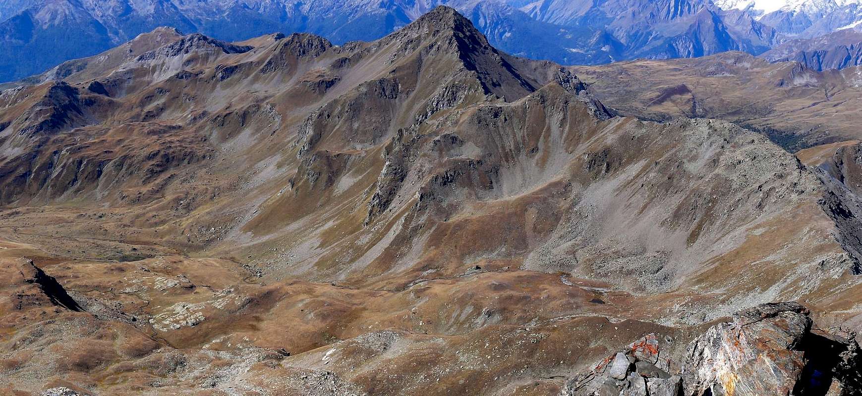
Both because, when viewed from the East, this small chain proposes, after Punta Leisse (+; 2.771m) or "Abandoned" but today more popular than ever, with a watershed of Vertosan Vallone adjacent (to the West), after the strait and similar "abandoned" Colle di Paletta (2.707m), form a small triangular-shaped tip spade and Mount Vertosan Rosso (2.940m), the higher elevation. So the same "down" to the next Mont Vertosan (2.822m), where the watershed begins to flex more in Northeast acting as a partition with the Vallone or Comba Flassin, reaches the Col Finestra (2.729m) to climb to the Mont definitely Fallère (3.061m), the highest elevation of this whole area above the municipalities of St. Nicolas, St. Pierre, Aosta and in the South, to the West Gignod and Etroubles toward the North in the Valle del Gran San Bernardo.
A crossing which can also be intrappresa from farther away starting from Aouillette (2.618m) in high Comba Northwest with Mass and bypassing the Punta Leissé or Leysser (2.771m), once virtually unknown and today highly sought after so much that you dispute a ' important race Ski-Mountaineering has been included in the world circuit. But we are interested more to go exploring the Eastern slope just above the Alpe Le Crotte (2.385/2.392m; singular stables with vaulted barrel-shaped) in a small valley more known by the hunters do not hikers. Or with a variant that runs the next more to North leaning directly against the Eastern Ridge of Mount Rosso (convenient in case of high or dangerous snow) "discarding" then both the Pass that the Punta Paletta. In any case should take its direction from South to the North, although it is not forbidden to cross the contrary as well as the extension of the trip (organize the return logistics) towards the adjacent in Southwest Punta Leissé or towards Aouilletta or Aouillette.
 |
Un piccolo badile, una vanga od anche una paletta oppure una montagna dal colore rosseggiante?
Entrambe tutte queste cose perché, se vista da Oriente ovvero dall'oblungo Vallone di Verrogne ai piedi della Becca France o dal Lago Morto sotto il versante Ovest del Fallère, questa piccola catena montuosa propone, dopo la Punta Leissé (+; 2.771 m) ovvero "Abbandonata" ma oggi più in voga che mai, uno spartiacque con l'attiguo Vallone di Vertosan (ad Ovest) che, dopo lo stretto ed ugualmente "abbandonato e semisconosciuto" Colle di Paletta (2.707 m), forma una puntina triangolare a forma di vanga ed il Monte Rosso di Vertosan (2.940 m), l'elevazione maggiore in questo tratto. Quindi il medesimo "disceso" al successivo Mont Vertosan (2.822 m), dove lo spartiacque inizia a flettere maggiormmente a Nordest fungendo da divisorio con il Vallone o Comba di Flassin a Settentrione, raggiunge il Col Finestra (2.729 m) per risalire definitivamente al Mont Fallère (3.061 m), massima elevazione di tutta questa, più che larga, vasta area sopra i Comuni di St. Nicolas, St. Pierre, Sarre ed Aosta a Meridione, Gignod verso Occidente ed Etroubles a Settentrione ormai decisamente nella Valle del Gran San Bernardo.
Una traversata che può essere intrappresa anche da più lontano partendo dall'Aouillette (2.618 m) nell'alta Comba Nordovest di Vetan e scavalcando la Punta Leissé o Leysser (2.771 m), una volta pressoché sconosciuta ed oggi assai frequentata tanto che si disputa un'importante gara di Sci-Alpinismo che é stata anche inserita nel circuito mondiale. Ma a noi interessa maggiormente di andare ad esplorare il Versante Orientale subito al di sopra dell'Alpe Les Crottes (2.392 m; stalle singolari con volte a forma di botte) in un piccolo vallone più noto ai cacciatori che non agli escursionisti. Oppure con una variante che percorre il successivo più verso Nord appoggiandosi direttamente contro la Cresta Orientale del Monte Rosso (conviene in caso di neve alta o pericolosa) "scartando" quindi sia il Passo che la Punta di Paletta. In ogni caso conviene tenere il senso di marcia da Sud al Nord, anche se non é vietata la traversata al contrario così come il prolungamento della gita (organizzare la logistica di rientro) alla Punta Leissé o all'Aouilletta.
Una traversata che può essere intrappresa anche da più lontano partendo dall'Aouillette (2.618 m) nell'alta Comba Nordovest di Vetan e scavalcando la Punta Leissé o Leysser (2.771 m), una volta pressoché sconosciuta ed oggi assai frequentata tanto che si disputa un'importante gara di Sci-Alpinismo che é stata anche inserita nel circuito mondiale. Ma a noi interessa maggiormente di andare ad esplorare il Versante Orientale subito al di sopra dell'Alpe Les Crottes (2.392 m; stalle singolari con volte a forma di botte) in un piccolo vallone più noto ai cacciatori che non agli escursionisti. Oppure con una variante che percorre il successivo più verso Nord appoggiandosi direttamente contro la Cresta Orientale del Monte Rosso (conviene in caso di neve alta o pericolosa) "scartando" quindi sia il Passo che la Punta di Paletta. In ogni caso conviene tenere il senso di marcia da Sud al Nord, anche se non é vietata la traversata al contrario così come il prolungamento della gita (organizzare la logistica di rientro) alla Punta Leissé o all'Aouilletta.
Getting There
Northwestern & Northeastern Getting There
BY CAR:
- From TORINO, MILANO, etc: Motorway A5. Exit at IVREA or Quincinetto (PIEDMONT).
- From IVREA Town: in West towards Pont Saint Martin, Donnas, Hône-Bard, Champdepraz, Saint Vincent, Châtillon Pontey, Fénis, Saint Marcel, Grand Brissogne, Pollein, Charvensod, Gressan, Jovençan, Aymavilles, to Villeneuve, St. Pierre, St. Nicolas, Arvier, AviseMunicipalities. From Courmayeur Resort: in East to Morgex, La Salle, Saint Pierre, Sarre, Aosta Municipalities.
![]()
From Aosta in West or by Courmayeur to the East towards Sarre, St. Pierre and St. Nicholas Communes - From Saint Pierre-Pommier (783m) towards Champretavy, Rumiod, alternative just after Persod (1.351m), Ravoise, Chaillod, Clavel, Cerlogne (1.580m) and Vens small Villages (1.750m), with Regional Road in West-northwest. From this last to Joux Saddle (1.930m); through short, always by dirt road, descent to Vertosan small Valley.
- From Saint Pierre-Château Sarriod de la Tour, Rumiod, Petit and Grand Sarriod (1.444/5m), Gerbore, Vetan Dessous (1.670m) and Dessus (1.737m), with Regional Road to Vetan Basin. From this, through dirt road, towards Genevrine Pasture, Chatalanez, Toules, Grand Arpilles Alps to Chaz Creuse small Basin (2.398m).
- From Sarre (657m), with Regional Road, towards Plèod, Vert Dessous and Dessus, Vareille, Caillod/Ville sur Sarre/Remondet, Moulin/la Cort, forks 1.225, 1.301 meters, Salet, Chavalançon (1.426m) small Villages to Thouraz Dessous and Dessus Hamlets (1.652m); from the last to Closella and Met small Valleys.
![]()
- From FRANCE: through the Mont Blanc Tunnel to Entrèves-crossroads to Vény/Ferret Valleys - Mountain Guides of Courmayeur - La Saxe Rock Gym - Courmayeur. By Little Saint Bernard Pass, closed since November until half May to La Thuile Valley - Pré Saint Didier - Courmayeur. It is not necessary to take Motorway A5: you can drive on SS.26, in the direction of AOSTA - IVREA - TURIN.
BY PLANE:
- Aeroporto "Corrado Gex" Saint Christophe (Aosta).
Approach & Route Description

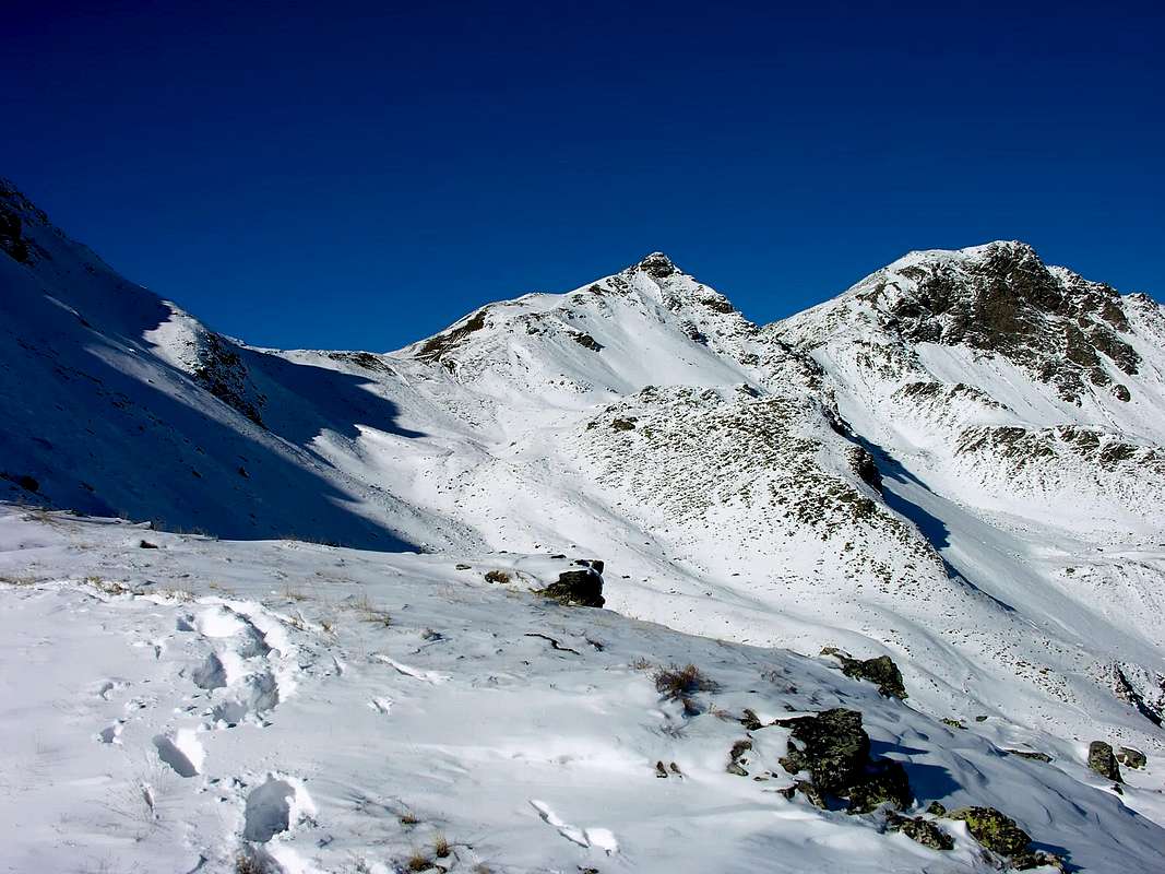
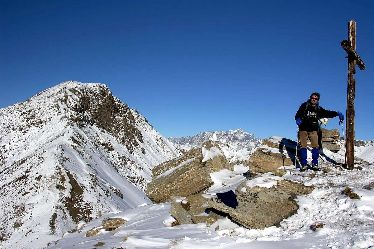
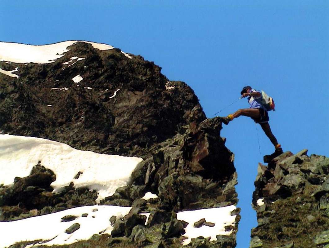
Traverse Col and Punta di Paletta to Monte Rosso of Vertosan (2.707m, 2.810m, 2.940m) with Approach from Verrogne Hamlet or by Vetan's Basin Verrogne (1.595 m) with the trail n° 10A/11 to the Loé Pasture (1.986m) from where you continue with that n° 11A/10 to the Lac de Grenouilles (2.363m; E/F; 2h'20/2h'40). From the pond through the trail n° 13 to the other 2.377 meters and Alp les Crottes (2.385m; 0h'15). From this, crossing toward the Southwest in a small vallon can be reached with the path n° 13A the paletta(z) Pass (2.707m; E/F; 1h'00/1h'15); following the ridge watershed is easy to reach the Punta Paletta (2.810m), from which it descends through the short but exposed North Ridge to a notch (I°+/II-, exposed and to circumvent to the West by a grassy ledge). From this easily along the wide South Crest to Monte Rosso (2.940m; EE/F+ with a sudden stretch of PD-; 2h'15/2h'45 Les Crottes; 4h'30/5h'00 by Verrogne also by Vetan wide and adjacent Basin).
Variation: from Le Crottes Alp (2.385/92m) or from water intake (2.329m), immediately before the same, reaching Westward, always following the trail n° 13A, the small above rocky-grassy promontory 2.474 meters up to the crossroads at 'junction with the trail from Alpe Les Crottes. From this point leave the same, which continues to the left (Southwest) reaching Col Paletta or Palettaz, continuing instead right on Ridge East-southeast, just a little evident, towards the Monte Rosso. After reaching the altitude of 2.570 meters and the next 2.746 meters, in a short time and with a few more "fun" passage that is difficult to reach the Summit (EE/F with the stroke F+; 1h'45/2h'15 from Les Crottes; 3h'30/4h'00 from Village of Verrogne also from Vetan). This Variant that is a "loophole" in the event of dangerous snow conditions, but circumvents the original route.
Traversata dal Colle e Punta di Paletta al Monte Rosso di Vertosan (2.707 m, 2.810 m, 2.940 m) con Avvicinamento dal Villaggio di Verrogne oppure da Vetan, da Verrogne (1.595 m) con il sentiero n° 10A/11 per l'Alpe di Loé (1986 m) dalla quale si prosegue con quello n° 11A/10 fino al Lac de Grenouilles (2.363 m; E/F; 2h'20/2h'40). Dal laghetto tramite il sentiero n° 13 all'altro 2.377 metri ed all'Alpe Les Crottes (2.385/92 m; 0h'15). Da questa, traversando verso Sudovest in un valloncello si raggiunge con il sentiero 13A il Colle di Paletta oppure Palettaz (2.707 m; E/F; 1h'00/1h'15); seguendo lo spartiacque si raggiunge facilmente la Punta di Paletta(z) (2.810 m), dalla quale si scende tramite la corta ma esposta Cresta Nord ad un intaglio (I°+/II°-, esposto ed aggirabile ad Ovest per cengia erbosa). Da questo facilmente al Monte Rosso lungo la facile e larga Cresta Sud (2.940 m; EE/F+ con un tratto PD-; 2h'15/2h'45 da Les Crottes; 4h'30/5h'00 da Verrogne o dal vasto nonché adiacente Bacino di Vetan).
Variante: dall'Alpe Les Crottes (2.385/92 m) oppure dalla presa dell'acqua (2.329 metri) subito antecedente raggiungere verso Ovest, sempre seguendo il sentiero n° 13A, il piccolo promontorio roccioso-erboso soprastante fino al bivio 2.474 metri all'incrocio con il sentiero dall'Alpe Le Crotte. Da questo punto abbandonare il medesimo, che prosegue verso sinistra (Sudovest) raggiungendo il Colle Paletta, continuando a destra sulla Cresta Est-sudest, appena in rilievo, del Monte Rosso. Raggiunta l'altitudine di 2.570 metri e la successiva di 2.746 metri, in breve tempo e con qualche passaggio più "divertente" che difficile si raggiunge la Sommità (EE/F con un tratto F+; 1h'45/2h'15 da Les Crottes; 3h'30/4h'00 dal Villaggio di Verrogne o da Vetan). Variante che costituisce una "scappatoia" in caso di condizioni pericolose di innevamento, ma eludendo il percorso originario.
![]()
Equipaggiamento: da Escursionismo.
Difficulty: this route can be considered EE/F+, with a "delicate" step just in North of Punta Paletta.
Difficoltà: l'itinerario è da classificare in EE/F+, con un passaggio "delicato" a Nord della Punta Paletta.
Variante: dall'Alpe Les Crottes (2.385/92 m) oppure dalla presa dell'acqua (2.329 metri) subito antecedente raggiungere verso Ovest, sempre seguendo il sentiero n° 13A, il piccolo promontorio roccioso-erboso soprastante fino al bivio 2.474 metri all'incrocio con il sentiero dall'Alpe Le Crotte. Da questo punto abbandonare il medesimo, che prosegue verso sinistra (Sudovest) raggiungendo il Colle Paletta, continuando a destra sulla Cresta Est-sudest, appena in rilievo, del Monte Rosso. Raggiunta l'altitudine di 2.570 metri e la successiva di 2.746 metri, in breve tempo e con qualche passaggio più "divertente" che difficile si raggiunge la Sommità (EE/F con un tratto F+; 1h'45/2h'15 da Les Crottes; 3h'30/4h'00 dal Villaggio di Verrogne o da Vetan). Variante che costituisce una "scappatoia" in caso di condizioni pericolose di innevamento, ma eludendo il percorso originario.
Essential Gear
Equipement: for Hiking.Equipaggiamento: da Escursionismo.
Difficulty: this route can be considered EE/F+, with a "delicate" step just in North of Punta Paletta.
Difficoltà: l'itinerario è da classificare in EE/F+, con un passaggio "delicato" a Nord della Punta Paletta.
Campings
Remember that free camping is forbidden (except for emergency reasons, over 2.500m, from darkness until dawn).Mountain Condition
- Meteo: you can find all the needed informations at the official site of the Valle d'Aosta Region:
- Valle d'Aosta Meteo
Important Information
- REGIONE AUTONOMA VALLE D'AOSTA the official site.
- FONDAZIONE MONTAGNA SICURA Villa Cameron, località Villard de la Palud n° 1 Courmayeur (AO) Tel: 39 0165 897602 - Fax: 39 0165 897647.
- A.I.NE.VA. (Associazione Interregionale Neve e Valanghe).
Useful numbers
- Protezione Civile Valdostana località Aeroporto n° 7/A Saint Christophe (Ao) Tel. 0165-238222.
- Bollettino Meteo (weather info) Tel. 0165-44113.
- Unità Operativa di Soccorso Sanitario Tel. 118.