


-
 3148 Hits
-
 80.49% Score
-
 12 Votes
|
|
Route |
|---|---|
|
|
45.83810°N / 7.46824°E |
|
|
Mountaineering, Trad Climbing |
|
|
Summer, Fall |
|
|
A long day |
|
|
PD+/PD- (Shortly Difficult Average) |
|
|
Note
|
La montagna chiama i suoi figli, ed essi rispondono fedelmente al suo appello… Osvaldo Cardellina, Diario alpinistico, 1964-65 Page texts: @ OsvaldoCardellina "Osva", passed away on May 2, 2022. Page owners: Christian Cardellina e Osvaldo Cardellina. Any updates from September 12, 2022: Antonio Giani, page administrator, friend and climbing companion. Testi della pagina: @ OsvaldoCardellina "Osva", scomparso il 2 maggio 2022. Proprietari pagina: Christian Cardellina e Osvaldo Cardellina. Eventuali aggiornamenti dal 12 settembre 2022: Antonio Giani, amministratore della pagina, amico e compagno di salite. |
Overview
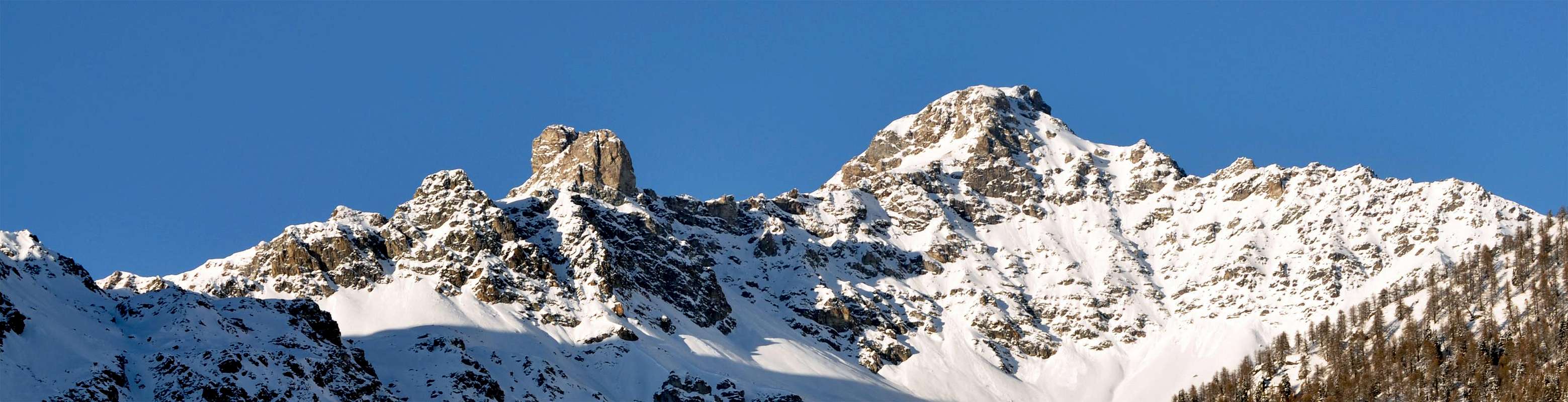
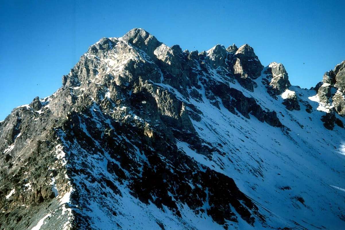
These two beautiful and adjacent Summit dominate, along with the nearby Becca del Merlo (3.237m), the area of Sanctuary of the Cuney (2.656m) and the opposite Comba de Montagnaye collocated above the Bionaz Common at the end of Valpelline.
Both are very rarely haunted because the apparent difficulty that flaunt on the side St. Barthélemy, while in the opposite of Montagnaye the access is very long and does not have the support points if not the Bivouac of the Forest Rangers of Aosta Valley (2.019m; private and always closed) nearby the l'Arp Damon. Formed by rocks not very good, yet worth a visit if only for the wonderful views that offer above the same and towards the entire circle of Pennine Alps and the nearby famous and beautiful pyramid of Becca di Luseney (3.503m), while just below and to the Southwest rises the "Gothic Catedral" of Monte Faroma (3.073m). For these specific reasons their Mountaineering History is rather limited and fairly recent in time. So much so that, while the Mont Pisonet was increased in June 25th, 1893 by the "classic & proven" Piedmontese rope consisting by Ettore Canzio, Cesare Fiorio, Felice Mondini, Nicola Vigna with the famous of Val d'Aosta Guido Rey, for Cima Franco Nebbia (initially nameless and dedicated to the Climber of Turin Franco Nebbia, that he fell at the age of thirty years on the icy Northern Wall of the Obergabelhorn in August 16th, 1957) you have to even wait for the September 11th, 1961 to record the first absolute ascent. In fact, after an attempt made in June 27th, 1920 by Gustavo A. De Petro with Pompeo Viglino they are Garimoldi Giuseppe and Enrico Lavagno who can climb the summital turret or most elevated point. A majority support of this just expressed, are not some winter ascents on both peaks. But, always performing an accurate distinction, while as regards the Mont Pisonet (from local place names "pisson or peson and even pisson", ie that piss with small torrents and tiny cascades of water on the slabs of the rocks) the climbs of its ridges and walls have already been, even if not known, made for the ease of routes, regarding the Cima Franco Nebbia there still something to explore maybe discovering new ways on Eastern Face right above the famous and popular Shreene of Cuney. We Refer to young people of good will with the invitation, the task and the proof ...
Both are very rarely haunted because the apparent difficulty that flaunt on the side St. Barthélemy, while in the opposite of Montagnaye the access is very long and does not have the support points if not the Bivouac of the Forest Rangers of Aosta Valley (2.019m; private and always closed) nearby the l'Arp Damon. Formed by rocks not very good, yet worth a visit if only for the wonderful views that offer above the same and towards the entire circle of Pennine Alps and the nearby famous and beautiful pyramid of Becca di Luseney (3.503m), while just below and to the Southwest rises the "Gothic Catedral" of Monte Faroma (3.073m). For these specific reasons their Mountaineering History is rather limited and fairly recent in time. So much so that, while the Mont Pisonet was increased in June 25th, 1893 by the "classic & proven" Piedmontese rope consisting by Ettore Canzio, Cesare Fiorio, Felice Mondini, Nicola Vigna with the famous of Val d'Aosta Guido Rey, for Cima Franco Nebbia (initially nameless and dedicated to the Climber of Turin Franco Nebbia, that he fell at the age of thirty years on the icy Northern Wall of the Obergabelhorn in August 16th, 1957) you have to even wait for the September 11th, 1961 to record the first absolute ascent. In fact, after an attempt made in June 27th, 1920 by Gustavo A. De Petro with Pompeo Viglino they are Garimoldi Giuseppe and Enrico Lavagno who can climb the summital turret or most elevated point. A majority support of this just expressed, are not some winter ascents on both peaks. But, always performing an accurate distinction, while as regards the Mont Pisonet (from local place names "pisson or peson and even pisson", ie that piss with small torrents and tiny cascades of water on the slabs of the rocks) the climbs of its ridges and walls have already been, even if not known, made for the ease of routes, regarding the Cima Franco Nebbia there still something to explore maybe discovering new ways on Eastern Face right above the famous and popular Shreene of Cuney. We Refer to young people of good will with the invitation, the task and the proof ...
Queste due belle ed adiacenti Cime dominano, insieme alla vicina Becca del Merlo (3.237 m), il Santuario del Cuney (2.656 m) e la Comba di Montagnaye.
Entrambe risultano veramente molto di rado frequentate per l'apparente difficoltà che ostentano sul lato St. Barthélemy, mentre in quell'opposto di Montagnaye (sopra il Comune di Bionaz e non molto prima della Diga di Place des Moulins in Valpelline) l'accesso risulta molto lungo e non presenta punti d'appoggio se non il Bivacco della Forestale Valdostana (2.019m; privato e sempre chiuso) nelle vicinanze de l'Arp Damon. Formate da roccia non molto buona, ciononostante meritano una visita se non altro per gli splendidi panorami che offrono sulla medesima e sull'intera cerchia delle Alpi Pennine nonché sulla vicina, famosa e splendida piramide della Becca di Luseney (3.503 m), mentre appena al di sotto e verso Sudovest si eleva quella dell'apparente "Cattedrale Gotica" del Monte Faroma (3.073 m). Per queste specifiche motivazioni la loro Storia Alpinistica risulta piuttosto limitata ed abbastanza recente nel tempo. Tanto che, mentre il Mont Pisonet é stato salito nel Giugno 1893 dalla "classica" cordata piemontese composta da Ettore Canzio, Cesare Fiorio, Felice Mondini, Nicola Vigna con il celeberrimo valdostano Guido Rey, per la Cima Franco Nebbia (inizialmente priva di nome e dedicata all'Alpinista Torinese Franco Nebbia, caduto all'età di trent'anni sulla Parete Nord dell'Obergabelhorn il 16 Agosto 1957) si deve addirittura attendere l'11 di Settembre 1961 per registrare la prima ascensione assoluta. Infatti, dopo un tentativo effettuato nel 27 di Giugno del 1920 da parte di Gustavo A. De Petro con Pompeo Viglino, sono Giuseppe Garimoldi ed Enrico Lavagno che riescono a scalare la torretta sommitale o punto maggiormente elevato. A maggior suffragio di quanto appena espresso, non risultano ascensioni invernali di alcun tipo su di entrambe le Vette. Ma, sempre effettuando un preciso distinguo, mentre per quanto concerne il Mont Pisonet (dai toponimi locali "pisson, peson e Pisson", ovvero che piscia con cascatelle d'acqua sulle placche rocciose) le salite delle sue creste e pareti sono già state, anche se non conosciute, effettuate vista la facilità degli itinerari, per quanto riguarda la viciniora Cima Franco Nebbia esiste ancora qualcosa da esplorare scoprendo magari nuove vie sul Versante Orientale giusto al di sopra del Santuario di Cuney. Ai giovani di buona volontà demandiamo invito, compito e prova ...
![]()
In the Summit: Garimoldi Giuseppe and Enrico Lavagno; September 11th, 1961, after a try by Gustavo A. De Petro with Pompeo Viglino; June 27th, 1920
In winter: Unknown.
East Slope (Gully or Standard Via from Cuney): by Gustavo A. De Petro with Pompeo Viglino; June 27th, 1920.
East-northeast Wall: by Osvaldo Cardellina, Marco Cossard and Giuseppe Lamazzi; August 15th, 1982 with traverse to Mont Pisonet and descent to Vessona Pass.
First Ascents
Cima Franco NebbiaIn the Summit: Garimoldi Giuseppe and Enrico Lavagno; September 11th, 1961, after a try by Gustavo A. De Petro with Pompeo Viglino; June 27th, 1920
In winter: Unknown.
East Slope (Gully or Standard Via from Cuney): by Gustavo A. De Petro with Pompeo Viglino; June 27th, 1920.
East-northeast Wall: by Osvaldo Cardellina, Marco Cossard and Giuseppe Lamazzi; August 15th, 1982 with traverse to Mont Pisonet and descent to Vessona Pass.
 |
 |
 |
Mont Pisonet
In the Summit: by Ettore Canzio, Cesare Fiorio, Felice Mondini, Nicola Vigna and Guido Rey; June 25th, 1893.
In winter: Unknown.
Northeast Slope and North Crest: by Ettore Canzio, Cesare Fiorio, Felice Mondini, Nicola Vigna and Guido Rey; June 25th, 1893.
Eastern Face: by Osvaldo Cardellina, lone; June 13th, 1985, with descent directly on North-northeast Slope.
Southeast Ridge: Osvaldo Cardellina, Mario David and Danilo Garzotto; November 08th, 1986, in ascent and in descent from Becca Fontaney round trip.
South Wall: by Pompeo Viglino, solo; June 27th, 1920.
West-southwest Wall: by Gustavo A. De Petro, lone; June 27th, 1920.
West Face (Rib): by Osvaldo Cardellina, Marco Cossard and Giuseppe Lamazzi; August 15th, 1982, with descent towards Vessona's three Jags and Pass.
North-northwest Slope (Normal Via by Oyace): Unknown.
BY PLANE:
![]()
From Saint Barthélemy Valley
In the Summit: by Ettore Canzio, Cesare Fiorio, Felice Mondini, Nicola Vigna and Guido Rey; June 25th, 1893.
In winter: Unknown.
Northeast Slope and North Crest: by Ettore Canzio, Cesare Fiorio, Felice Mondini, Nicola Vigna and Guido Rey; June 25th, 1893.
Eastern Face: by Osvaldo Cardellina, lone; June 13th, 1985, with descent directly on North-northeast Slope.
Southeast Ridge: Osvaldo Cardellina, Mario David and Danilo Garzotto; November 08th, 1986, in ascent and in descent from Becca Fontaney round trip.
South Wall: by Pompeo Viglino, solo; June 27th, 1920.
West-southwest Wall: by Gustavo A. De Petro, lone; June 27th, 1920.
West Face (Rib): by Osvaldo Cardellina, Marco Cossard and Giuseppe Lamazzi; August 15th, 1982, with descent towards Vessona's three Jags and Pass.
North-northwest Slope (Normal Via by Oyace): Unknown.
Getting There
BY CAR:- From TORINO, MILANO, etc: Motorway A5. Exit at IVREA, Quincinetto (PIEDMONT), Pont Saint Martin, Verrès, Châtillon/Saint Vincent an Aosta East (Nus).
- From Courmayeur-Mont Blanc to Morgex Commune with SS.26; font this with Motorway A5. Exit at Aosta West (Aymavilles) or Aosta East (Nus).
- From IVREA Town: in West to Pont Saint Martin, Donnas, Verrès, Arnad, Montjovet, Hone, Saint Vincent, Châtillon, Nus Municipalities, through SS.26.
- From Courmayeur Resort: in East to Pré Saint Didier, Morgex, La Salle, Saint Pierre, Sarre, Aosta, Nus Communes, through SS.26.
![]()
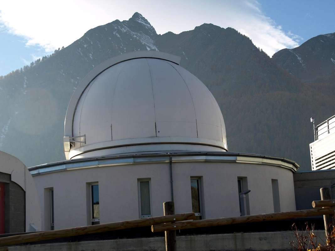
Lignan Astronomical Observatory - From FRANCE: through the Mont Blanc Tunnel to Entrèves-crossroads to Vény/Ferret Valleys - Mountain Guides of Courmayeur - La Saxe Rock Gym - Courmayeur. By Little Saint Bernard Pass, closed since November until half May to La Thuile Valley - Pré Saint Didier - Courmayeur.It is not necessary to take Motorway A5: you can drive on SS.26, in the direction of AOSTA - IVREA - TURIN.
BY PLANE:
- Aeroporto "Corrado Gex" Saint Christophe (Aosta).
SPECIFIC ROAD
- From Nus, with regional Road, towards Marsan (699m), Petit Fénis (939m), Blavy (1.056m) Fractions and Val Dessous (1.173m) and Dessus (1.268m), Les Fabriques (1.411m), Issologne (1.514m) small Villages towards Lignan-St. Barthélemy (+; 1.633m; Astronomical Observatory), in the middle-center of St. Barthélemy Valley.
Approach & Route Description
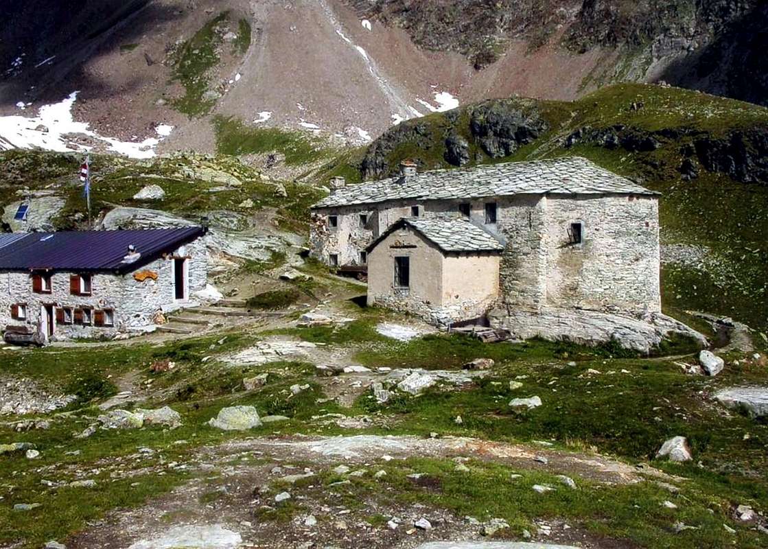
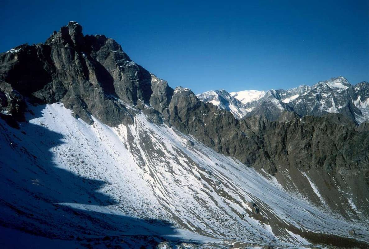
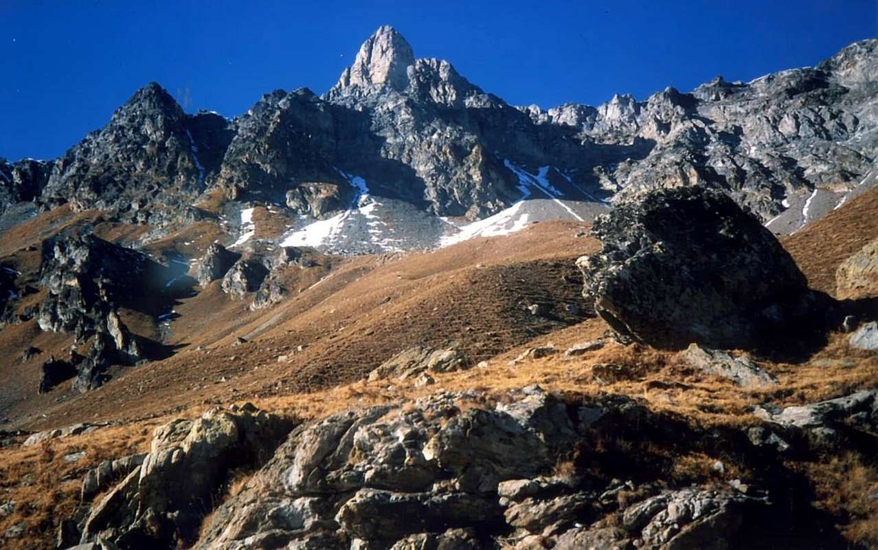
Approach from Lignan Hamlet: from Lignan (1.633m) with Municipal Road in asphalt towards Porliod with the Picnic Area (1.879m), neighbor Larset Villages, through dirt road concomitant with the trail n° 14 (cross-country skiing run) in Northeast towards fork just before Praz de Verney (1.870m) and below Barbonce, La Nouva Pastures, towards Champcombre (1.930m) Alp, Champlaisant Sanctuary (+; 1.906m), Veyoux Alp (1.987m), Refuge La Servaz (+; 2.070m), near homonym alp (2.005m); from this with path n° 12 towards La Reche Alp (2.388m) and Cuney Sanctuary (+; Refuge Oratory; 2.653m; EE/F; 2h'45/3h'15), below the semi circular range amongst Becca Fontaney (2.972m), Mont Pisonet (3.207m), Franco Nebbia (3.205m), Becca of Merlo (3.231m), Cuney Pass (2.917m) and Montagnayes Summit (3.049m), into Cuney Comba or Basin. (EE/F; 2h'45/3h'15 from Lignan). From Refuge-Sanctuary of Cuney crossings to the West through bumps and rocky meadows with large boulders that increase progressively in steepness and sometimes with snowfields residues; go up to the Eastern Wall in direction of the gully that runs through the middle. Overcome relatively easily the same, formed by fine debris or hard snow, until reaching a bottleneck characterized by a large boulder that occludes; around this stretch almost vertically just to the left (South; II°+/ III°-) then continue on the edge, always left, of the channel reaching a marked fork just to the South of the Cima. From this climb through the Southern Ridge up to the summital turret coming to a block, which is won by an exposed pass on its Northern Edge (III°/III°+; A/PD+; 2h'15/2h'45 from Sanctuary). Downhill, after returning to the fork, it passes easily the next big rounded shoulder and, after half a dozen elevations not important, easily you reach on Mont Pisonet through its Ridge North-northwest. Back in Cuney through the final part of the same crest and then on its Northeastern Slope by moderate slope (EEA/F+; 1h'00/1h'15 for the entire crossing; 3h'30/4h'00 in total).
![]()
Dalla Valle di Saint Barthélemy
Avvicinamento e Via da Lignan: dal Villaggio di Lignan (1.633 m) con la Strada Municipale in asfalto verso quello di Porliod con la sua Pic Nic Area (1.879 m), nelle vicinanze del Villaggio appena soprastante di Larset che si raggiunge con poderale concomitante al sentiero n° 14 (pista per il fondo) in direzione Nordest verso il bivio appena prima degli Alpeggi di Praz de Verney (1.870 m) nonché sotto quelli di Barbonce, La Nouva Pastures, verso le Alpi di Champcombre (1.930 m) e Champlaisant Sanctuario (+; 1.906 m), l'Alpe Veyoux (1.987 m), ed il Rifugio La Servaz (+; 2.070 m), presso l'omonima alpe (2.005 m). Da quest'ultima tramite sentiero n° 12 verso l'Alpe La Reche (2.388 m) ed il soprastante Santuario del Cuney (+; Rifugio Oratorio; 2.653 m; EE/F; 2h'45/3h'15), al di sotto della catena montuosa con forma semicirculare tra le Cime Becca Fontaney (2.972 m), Mont Pisonet (3.207 m), Franco Nebbia (3.205 m), Becca del Merlo (3.231 m), Colle del Cuney (2.917 m) e Punta di Montagnayes (3.049 m), internamente alla Comba o Bacino del Cuney. Dal Rifugio-Santuario del Cuney traversare verso Occidente tramite dossi prativi e pietraie con grandi massi che aumentano progressivamente in ripidezza ed a volte con nevai residui; salire verso la Parete Orientale in direzione del canalone solcantela nel mezzo. Superare abbastanza agevolmente il medesimo, formato da fini detriti o neve, fino a raggiungere una strettoia caratterizzata da un grande masso che l'occlude; aggirare questo tratto quasi verticale subito sulla sinistra (Sud; II°+/III°-) continuando poi sulla sponda, sempre sinistra, del canale raggiungendo una marcata forcella appena a Sud della Cima. Da questa salire tramite la cresta Meridionale fino alla torretta sommitale arrivando ad un blocco, che si vince tramite un esposto passaggio sul suo spigolo Settentrionale (III°/III°+; A/PD+; 2h'15/2h'45 dal Santuario). In discesa, dopo essere rientrati alla forcella, s'oltrepassa facilmente il successivo spallone arrotondato e dopo una mezza dozzina di elevazioni non importanti, si raggiunge il Mont Pisonet tramite la sua Cresta Nord-nordovest. Rientrare nel Cuney per mezzo della parte finale della stessa e quindi sul suo Versante Nordest (EEA/F+; 1h'00/1h'15 per l'intera traversata).
![]()
This route can be considered EEA/PD+/PD- (Experts Hikers and Mountaineers); BSA in winter (even by Ski).
L'itinerario è da classificare in EEA/PD+/PD- (Escursionisti Esperti od Alpinisti) BSA in inverno (anche in Scialpinismo).
Essential Gear
DIFFICULTIESThis route can be considered EEA/PD+/PD- (Experts Hikers and Mountaineers); BSA in winter (even by Ski).
L'itinerario è da classificare in EEA/PD+/PD- (Escursionisti Esperti od Alpinisti) BSA in inverno (anche in Scialpinismo).
 |
 |
 |
EQUIPMENT
High Hiking gear, in winter as for Ski-Mountaineering.
Da Alto Escursionismo, in inverno da Scialpinismo.
High Hiking gear, in winter as for Ski-Mountaineering.
Da Alto Escursionismo, in inverno da Scialpinismo.
Campings
Remember that free camping is forbidden (except for emergency reasons, over 2.500m, from darkness until dawn).Mountain Condition
- Meteo: you can find all the needed informations at the official site of the Valle d'Aosta Region:
- Valle d'Aosta Meteo
Important Information
- REGIONE AUTONOMA VALLE D'AOSTA the official site.
- FONDAZIONE MONTAGNA SICURA Villa Cameron, località Villard de la Palud n° 1 Courmayeur (AO) Tel: 39 0165 897602 - Fax: 39 0165 897647.
- A.I.NE.VA. (Associazione Interregionale Neve e Valanghe).
Useful numbers
- Protezione Civile Valdostana località Aeroporto n° 7/A Saint Christophe (Ao) Tel. 0165-238222.
- Bollettino Meteo (weather info) Tel. 0165-44113.
- Unità Operativa di Soccorso Sanitario Tel. 118.