Trekking in Pakistan
Pakistan is a dreamland for trekkers and hikers. Most of the trekking routes situated in the Mountain Ranges of Karakoram, Western Himalayas, and Hindukush. The best trekking season is between May to end of October each year.
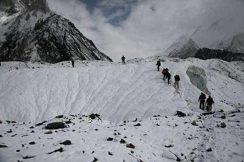
![Baltoro Glacier, Karakoram, Pakistan]() Trekkers towards Concordia
Trekkers towards ConcordiaSituated in the heart of the South Asian sub-continent, it is a country with rich history and cultural tradition, captivating in its own right. Pakistan is situated between 24.5 and 36.75 degree north latitude and 61 and 75.5 degree east longitude. It is bordered by China in the North, Afghanistan and Iran in the West and India in the East. Arabian Sea lies to its South with 1000 kilometers long coastline with fascinating beaches. Pakistan is linked with China through land by Karakoram Highway along the great Silk Route while it is linked with India by air, rail and road. Iran and Afghanistan are linked with Pakistan by air and road.
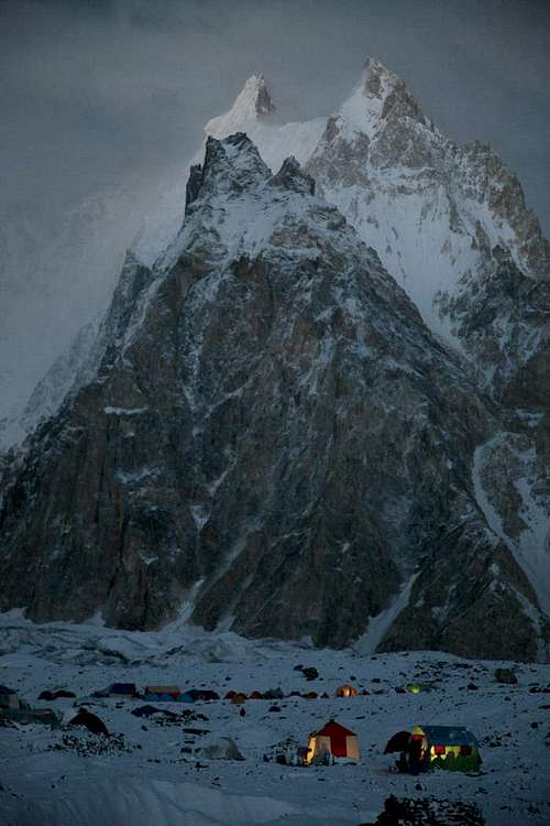
![Camping at Baltoro Glacier]() Camping at Baltoro Glacier
Camping at Baltoro GlacierNature has blessed Pakistan with matchless landscape, the high mountains, longest glaciers on earth outside the Polar Regions, deserts; plains, plateau, and attracting sunny beaches are all found here. However, more than fifty percent of its Northern and North Western regions which possesses the most mesmerizing Mountains Ranges on earth. Splendid remains of continents collision, 65 million years ago, a massive landmass collided with the mainland of Asia to create the South Asian Sub-Continent and push the Himalayas skyward. The mighty ranges, Karakoram, the Himalayas, and the Hindukush make a meet here.
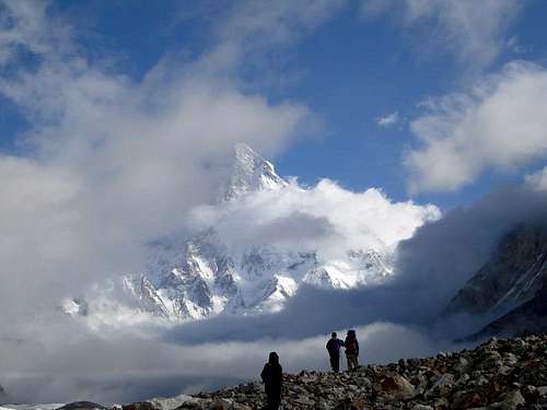
![K-2 (8611m), Karakoram, Pakistan]() Trekkers at Concordia
Trekkers at ConcordiaIn these great mountain ranges, found the mountains of awe-inspiring heights, longest glaciers on earth outside the Polar Regions, valleys of unsurpassable beauty, dotted with quiet lakes, crystal clear blue water, through with murmuring streams and springs and thundering rivers, above all the mighty river Indus.
The Karakoram Highway and further secondary roads have made it easier and quicker to reach starting points of the treks into the regions. Enjoyable trekking programs ranging from a few days to 40 days can be arranged. Some of smaller routes can also be connected jointly. Numerous treks passes through fierce and rugged scenery, lead over long glaciers and end at the base of a high peak, some of the trekking routes cross high passes, some of which have become technical ascents due to drastic changes in the pattern and movement of glaciers.
Covered accommodations or hotel is not very frequent, but frequently the trekker, hikers have to depend on camping gears. Wood is very limited and oil/gas-burning stove is very important. Air flights operate between, Islamabad-Skardu, Islamabad-Gilgit, and Peshawar-Islamabad-Chitral, subject to clear weather conditions. The roads between these cities are paved. Other secondary roads in the side valleys are rough and dusty, but beautiful. Jeep services are available between one important point and another and they carry passenger too. However, a journey by one of these conveyances is painful. One can also hire special jeeps at the main cities of Gilgit, Hunza, Chitral, Skardu, Khaplu and Shigar.
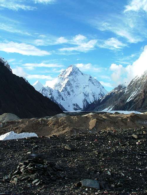
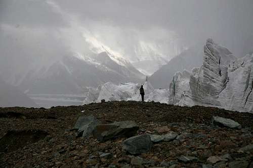
![K2]() K-2 as seen from Concordia
K-2 as seen from ConcordiaA massive area of mountain deserts and crumbling rocks, bereft of any vegetation's and lightly populated, exhausted and gouged by fast flowing rivers fed by melting snows, the mighty mountain ranges of Pakistan, the Karakoram, the Western Himalayas and Hindukush, holds the greatest concentration of world’s highest peaks. No less than 4 of 14 Eight thousand meter peaks are situated round the Baltoro Glacier, within the distance 24 kilometers, rise up 10 of the world’s 30 highest peaks, including K-2 (8611m), Gasherbrum-I (8068m), Broad Peak (8047m), and Gasherbrum-II (8035m). One above 8000 meter peak is located in Western Himalaya, the Nanga Parbat (8125m). Baltoro ice stream,
![In the Shadows of highest Peaks on earth]() Baltoro Glacier
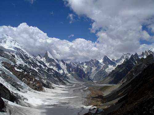
Baltoro GlacierThe Mountain ranges of Pakistan contains also some of the greatest glacier systems outside the Polar Regions, the longest of is the Siachen, 75 kilometers, Biafo, 68 kilometers, Baltoro, 62 kilometers, Batura, 58 kilometers, Hispar, 53 kilometers, Rimo, 45 Kilometers, Chogo Lungma , 47 kilometers, Panmah, 44 kilometers, Khurdopin, 41 kilometers, Saropo Laggo, 33 kilometers in length and many more.
The Ministry of Tourism, Government of Pakistan, has defined trekking as walking below 6000 meters (for the year 2010 it is relaxed up to 6500m) with the purpose of sight-seeing and recreation at various natural and cultural sites in places where means of modern transport are either not available or are purposely not used. It has designated three zones for trekking; Open, restricted and closed. Foreigners may trek anywhere in open zone without a permit and services of licensed mountain guide. For trekking in restricted zone, foreigners must pay a prescribed fee of 50 US$ per person per trek to obtain a trekking permit from Ministry of Tourism, Islamabad. The validity of trekking permit is 30 days. It also requires hiring an approved/licensed mountain guide; buy a personal accident insurance policy for the guide, cook and porters and to attend a mandatory briefing and de-briefing at the Ministry of Tourism, Islamabad, at the beginning and the end of the trekking trip. No trekking is allowed in closed zone which are the areas near Pak-Afghanistan border and near the line of Control with Indian-held-Kashmir.
Treks in Baltistan
![Views from the Top of Gondogoro Pass]() Views from the top of the Gondogoro Pass
Views from the top of the Gondogoro Pass
For Treks in Baltistan, please visit TREKS IN BALTISTAN
Treks in Diamir
01- AROUND NANGA PARBAT:
Gilgit, Astore, Mazeno Pass, either to Chilas via Diamer or Kachal Pass, Fairy Meadows, Raikot or Astore via Nameless Pass, Chilas or vice versa
Open Zone
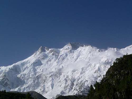
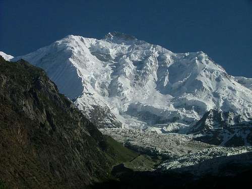
![Nanga Parbat]() Nanga Parbat
Nanga Parbat02- FAIRY MEADOWS:
Chilas, Fairy Meadows, Nanga Parbat Base camp, Jillipur Pass, Chilas.
Open Zone
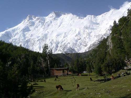
![Nanga Parbat (8125m) Seen from Fairy Meadows]() Fairy Meadows
Fairy Meadows 03- ACROSS DEOSAI:
Gilgit, Astore, Chillim, Deosai Plateau, Skardu or vice versa.
Open Zone
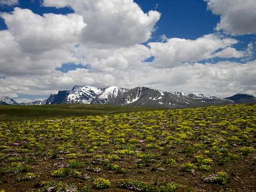
![Wild flowers in Deosai Plains]() Deosai Plains
Deosai Plains
Treks in Gilgit & Hunza
01. RAKAPOSHI BASE CAMP:
Gilgit, Jaglot, Shaltar Pass, Milt, Minapin Glacier Miachar, Toshot, Nagar, Gilgit or vice versa
Open Zone
![Mount Rakaposhi (7788-m)]() Rakaposhi (7788m)
Rakaposhi (7788m)
02. BATURA GLACIER:
Gilgit, Gulmit, Borit Lake, Patundas, Yashpirit, Shelmin, Lupdor & return vialeft side of the Batura Glacier to Passu, Gilgit or vise versa. Open Zone
03- GILGIT-HASSANABAD:
Gilgit, Hassanabad, Muchuhar Glacier, Shemdar Glacier, back to the Batoqsha, Glacier, Shisper Glacier, Hassanabad, Gilgit or vice versaOpen Zone
04. KARUN PASS:
Gilgit, Passu, Dut, Karun Pass, Biiber, Morkhun, Karakoram Highway & back to Gilgit or vice versa
Open Zone
05- CHAPURSAN BATURA:
Gilgit, Sost, Yashkuk by jeep & then by foot to Khunjerab pass & across Lupghar Pass & down to Raminji or cross across 5200-M Pass & down to the Batura Glacier to Passu or vice versa
Restricted Zone
06- BARPU GLACIER:
Gilgit, Hunza, Hopper, across Bualbar Glacier up the Barpu Glacier ascend to Rash Lake,Girgindal, Golden Peak Base Camp, return by let side of the Barpur Glacier to Hopper & to Gilgit or vice versa.
Open Zone
07- SHIMSHAL VALLEY:
Gilgit, Hunza, Sost, Chillinji Pass, Ishkomen, Gilgit or vice versa Restricted Zone
08- SHIMSHAL VALLEY:
Gilgit, Passu, Shhimshal, Yazghil Glacier, Yukshin Garden Glacier, Khurdopin Glacier, Vijerab Glacier, & return to Gilgit by the same route.
Open Zone
09- SHIMSHAL – CHAPCHINGAL PASS:
Gilgit, Passu, Shimshal, Boesam Pir Pass, Mundi Kushlaq, Chapehingal Pass, Karakoram Highway, Gilgit or vice versa.
Restricted Zone
10- SHIMSHAL PASS:
Gilgit, Passu, Shimshal, Shimshal Pass, Yazghil Glacier, Virjerab Glacier, Shimshal Pass, Shuijerab, Shimshal Village, Passu & return to same route.
Open Zone:
11- KARUN PASS:
Gilgit, Passu, Karun Pass, Beihar, Merkhun, Sost, Gilgit or vice versa Open zone
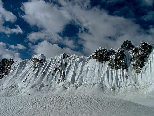
![Snow lake Karakoram]() Snow Lake
Snow Lake
12- SHIMSHAL – BRALDU GLACIER – SNOW LAKE:
Gilgit, Passu, Shimshal Village, Shuijerab, Braldu Glacier, Lukpo-La, Snow Lake, & to Nagar via Hisper La & Shisper Glacier, or to Askole & Skardu via Biafo Glacier, or vice versa
Restricted Zone
13- NALTAR PASS:
Gilgit, Cithar Nomal, Naltar Pass, Naltar Pass, or Sher Qila, Naltar, Naltar Pass, down to either Chaterkhand or to Pakhera, to lmit, down to Gilgit or vice versa
Open Zone
14- DAINTER PASS:
Gilgit, Nomal, Naltar, Dinter Pass,Bar, Kukuar Glacier, Balter Glacier, Chalt to Gilgit or vice versa
Open Zone
15- THUI PASS:
Gilgit, Yasin, Nazbar Pass, Gazin, Mastuj, Chitral or vice versaOpen Zone
16- NAZBAR PASS:
Gilgit, Yasin. Nialthi, Nazbar Pass, Zagar Pass, Shandur Pass, Mastuj, Chitral, or vice versa
Open Zone
17- DADAR ALI PASS:
Gilgit, Phandar, Handrap, Dadarali Pass, Kalam, Swat, or vice versa. Or same up to Handrap & continue to Swat via, Bashkaro Pass & Kalam or vice versa
Open Zone
18- ASUMSAR & ISHKOMAN PASSES:
Gilgit, Chatorkhand, Asumbar Pass, Sandi, Darkot, Ishkoman Pass,Ishkoman, Gilgit or vice versa
Open Zone
19- ISHKOMAN & DARKUT PASSES:
Gilgit, Ishkoman, Ishkoman Pass, Darkot, Darkot Pass, Baroghil to Mastuj & back to Gilgit or Chitral.
Restricted Zone
20- NAZVAR PASS:
Gilgit,Yasin, Nazbar Pass, Zagar Pass, Chamarkhan Pass, Harchin Pass,Harchin & to Chitral orGilgit vice versa
Open Zone
21- HARAMOSH PASS:
Gilgit, Jaglot, Sassi, Dassu, Haramosh Pass, Arandu, Skardu or vice versa
Open Zone
22- HARAMOSH – RAKAN PASS – BAGROT:
Gilgit, Sassi, Rakan Pass, Farphu, Gilgit or vice versa
Open Zone
Treks in Chitral Valley
01- GARAM CHASHMA – AGRAM PASS:
Chitral, Mizhingram, Ovirdeh, Agram Pass,Gohar, Lutkuh, Chitral ofr vice versa
Restricted Zone
02- MAEDAKLASHT – PHAGRAM PASS:
Chitral, Madaklasht, Gelon valley, Phagram Pass, Laspur,Chitral or vice versa
Open Zone
03- KALASH –CHAMBOL PASS:
Chitral, Berir, Chamboi Pass, Bomboret, Kalashgaram, Rambur, Balangum, Bakmak, Chitral or vice versa
Restricted Zone
04= KHOT PASS:
Chitral, Turkhow, Khot Pass, Ochail, Ishkarwaz, Karambar Pass, Ishkoman Valley, Gilgit or vice versa
Restricted Zone
05- THUI PASS:
Chitral,Gazin, Thui Pass, Assombar, Gilgit or vice versa
Open Zone
06- KACHIKANI PASS:
Chitral, Mastuj, Kachikani Pass, Kalam, Swat, or vice versa
Open Zone
07- OVIR PASS:
Chitral, Shahbronz, Ovir Pass, Kiyar, Chitral or vice versa
Open Zone
08- KALASH –RUMBUR:
Chitral, Birmlghlasht, Utak Pass, Bashagallian,Rumbur, Bomboret or vice versa
Restricted Zone
09- DADRALI PASS:
Chitral, Mastuj, Andrap lake, Dadrali Pass, Kalam, Swat or vice versa Open Zone
10- ZANI PASS:
Chitral, Zani Pass, Shagram, Atrak, Babu Camp, Ziwar Gol, Burzun, Chitral or vice versa
Restricted Zone
11- TURKHOW VALLEY:
Chitral, Burzun, Ziwar, Shal, Uzhnu, Chikar Pass, Wakhikan Gumba, Kotgaz, Noghor Zom, Rua, Chitral or vice versa
Restricted Zone
12- SHAH JUNALI – CHILLIJI PASS:
Chitral, Rua, Shah Junali,Lasht, Iskharwaz, Karambar Pass, Chillinji Pass, Chapursan Valley, Gilgit or vice versa
Restricted Zone
13- CHUMURKAN PASS:
Chitral, Mastuj, Chumarkan,Nazbar Pass, Yasin, Ishkoman, Gilgit or vice versa
Opne Zone
14- ZINDIGRAM PASS TREK:
Chitral, Shah Junali, Paur, Gazin, Lasht, Kishmanja, Ishkarwarz to Darkot Pass, or Karambar Pass, Zindikharam Pass, Ishkoman, Gilgit or vice versa
Restricted Zone
15- ARKARI TREK:
Chitral, Shugur Blyasan,Babu Camp, Arkari, Gram Chashma, Shahgram, Chitral or vice versa
Restricted Zone
16- DARKOT PASS:
Chitral, Mastuj, Lasht, Darkot Pass, Ishkoman, Gilgit or vice versa Restricted Zone
17- CHILINJI TREK:
Chitral, Mastuj, lshkarwarz, Karambar Pass, Chillinji Pass, Chapursan Valley, Gilgit or vice versa
Restricted Zone
18- TIRICH VALLEY:
Chitral, Shahgram, Shangur Biyasan, Lower Trich Glacier, Upper Trich Glacier, and back by the same route
Restricted Zone


Comments
Post a Comment