Mount Emmons, South Mount Emmons, and Owl
I had been thinking about climbing Mount Emmons (13440), the fourth highest peak in Utah for some time. It appealed to me because it had a southern approach making it more accesible this time of year. Two other hikes I had recently done in the area, one to the
Paul Benchmark ridge, and one to
North and South Timothy Peaks, had both had great views of Mount Emmons and its surrounding ridge.
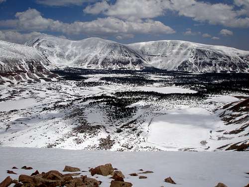
![Emmons, S Emmons, and Owl]() Emmons, S Emmons, and Owl, above Timothy Lakes Basin, May-31-2008
Emmons, S Emmons, and Owl, above Timothy Lakes Basin, May-31-2008
Mount Emmons didn't see much action. Exactly one person had signed the climbers log, two if you look at the Kings-Emmons Ridge page. As a comparison, the fourth highest peak in Colorado, Blanca Peak, had 101 entries in the climbers log as of 6-23-08.
|
![Topo of trip]() Topo of trip Topo of trip
I thought I'd have to wait until spring runoff died down because the way I had intended to go, a 20 mile RT about half on trail half off starting at Swifts Creek Trailhead (8100'), involved a major stream crossing that I didn't want to deal with. However, the idea of an 18 mile RT all off trail except for the first quarter mile popped into my head while working on the Timothy Peaks TR. Going this long a distance off trail seemed somewhat daunting, not to mention the 7000 feet total elevation gain. The route leaves the trail just before it crosses Swift Creek, a short distance from the campground and does a very steep bushwhack (almost 2000' in 1.25 miles) passing the north end of Water Lily Lake and continues until the lip is reached at 10100 feet where the grade eases considerably. It contours across the slope, gradually gaining Emmons' south ridge which is followed over three summits, 11841, Owl (12826), and South Emmons (13170) and finally ascends Emmons (13440).
I tried to find someone to go with on June 12, but got no takers except for one person who was willing to go if we either started at 3AM or 8PM the night before. I said "no thanks". I wasn't really into stumbling through the brush in the dark. Also, the temperatures on that particular night were to be in the teens and a few inches of new snow had fallen. Putting everything together, it didn't sound too pleasant. I opted instead for a local hike up Pheifferhorn with my friends Michael aka Moogie737 and Lana.
The next week I talked my husband and 11 year old son into combining my hike to Mount Emmons with a family camping trip. We set out for the Swift Creek Trailhead and campground Tuesday afternoon June 17, stopping at several locations along the way to do some geocaching. My husband's comment was "nice campground but hellacious drive". It seems I forgot to mention the dirt road part. I didn't think it was so bad, but he had never driven 20 miles on dirt/packed snow in the winter to Henrys Fork.
After turning north from Duchesne we had some good views of the peaks ahead, but unfortunately I couldn't tell one from another. The one thing I could tell was that some of them still had a fair amount of snow. I had decided I was sick of carrying the extra weight of snowshoes and hadn't brought them, reasoning that if the snow got too bad and I was sinking in too much I'd just turn around and save Emmons for another day, still traveling far enough to get a decent hike in. From previous trips I thought I could make it to at least 11000' without encountering significant snow and by that time I'd be on a south ridge that received lots of sun so hopefully I'd be ok. But now I was starting to have doubts.
We arrived at the campground and while I was in the bathroom and unable to protest, my not very safety-conscious (pc term for idiot) husband let our son drive our standard transmission car over to our camp site. Our son remarked at how the car had made lots of strange noises and my husband remarked how he had to take the car out of gear and use the emergency brake to keep the car from going into the outhouse.
The next morning while they lounged in bed until 8, had a leisurely breakfast, and left for an easy hike along the Yellowstone Creek trail at 10, I woke up at 4:30, gulped down some food and was on my way by 5:20AM.
|
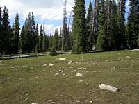
![Water Lily Lake]() Water Lily Lake Water Lily Lake![Nice section of bushwhack]() Nice section of bushwhack Nice section of bushwhack
After I turned off of the trail, I was able to stay on a series of little paths for some time until it seemed like they were diverging from my route too much. I suspect that they end up eventually on the south side of Water Lily Lake which would have been fine but I had planned to hit the north side of the lake and was afraid I'd be hosed if they didn't actually go to the lake. The terrain was very steep but didn't have much underbrush. The trees were fist sized thin and about 2 feet apart, barely enough room to squeeze through. I hit the lake and continued upward steeply until about 10100'. Now the terrain was much easier to navigate. It was gently sloped with big trees spaced widely apart. There was occasionally an annoying area with significant deadfall, but for the most part the going was easy. It was particulary nice skirting to the north of bump 10861, nice green meadows with lots of little streams running through them. There were periods of patchy snow, but nothing of any great consequence.
|
![Looking south at 11644, lots and lots of rocks]() Looking south at 11644, a small patch of tundra, but mostly rocks Looking south at 11644, a small patch of tundra, but mostly rocks
I hit tree line at 11000 feet and from then on it was mostly rocks, lots and lots and lots of rocks with an occasional brief patch of tundra. Sometimes they were easy to walk on and sometimes each step required thought but overall it wasn't so bad it's just that there were so many of them, as far as one could see.
|
![Owl (12826)]() Owl Owl![South Emmons and Emmons]() South Emmons and Emmons South Emmons and Emmons
I got to the top of 11841, an unexciting rounded mound of rocks, at 9:20, 3 hours after I had started. Owl (12826) lie ahead, another unexciting rounded mound of rocks. I've noticed that far away peaks in this area seem dramatic but when viewed up close do not. I lost about 300' of elevation and then began the long gradual ascent to Owl, 1300' in 1.3 miles, one rock step after another.
I made it to Owl before 11 and could finally see views of South Emmons and Emmons. They both had snow on their eastern sides, but the rest was only occasional patches. Some of the patches I walked through, but mostly I tried to avoid them if convenient. Sometimes they would support my weight, but sometimes they were completely soft and I'd sink in to my knees. All in all, less than 3% of this hike was on snow, amazing that one can get up to 13440 in the Uintas and have almost no snow, when the Wasatch is still mired in snow at 11000' and even at 9000' in north facing areas.
|
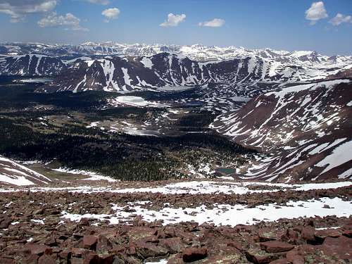
From the saddle between Owl and South Emmons I had a good view to the east into Krebs Basin and the dramatic ridge lining its south side.
![Krebs Basin]() Krebs Basin
Krebs Basin
To the west lay Timothy Lakes Basin. It was amazing to see how much snow had melted in the past 18 days. Here's what it looked like today.
![Timothy Lakes Basin]() Timothy Lakes Basin
Timothy Lakes Basin
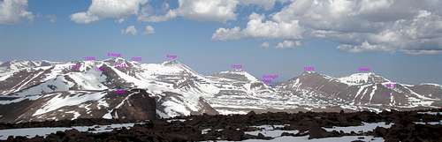
When I started the day there hadn't been a cloud in the sky, and the wind was completely still. Gradually throughout the morning, the clouds had been building and I wanted to get to Emmons and back down as quickly as possible. Way to the north the sky was still clear, but it was raining behind me to the south. I arrived at South Emmons at 11:45 and on Emmons by 12:30. I hadn't really thought about what would be in view but was wowed when I realized I was looking at Gunsight pass.
![View NW from Emmons]() View NW of Emmons
View NW of Emmons
I took some quick pictures, noted that the benchmark was in bad shape, and began my descent. Unfortunately, it wasn't just a descent, I had to go up and over South Emmons, Owl, and 11841 to get back, another 850 vertical feet.
![Timothy Peaks and Wilson Peak]() Timothy Peaks and Wilson Timothy Peaks and Wilson![Gunsight Pass]() Gunsight Pass from Mount Emmons Gunsight Pass from Mount Emmons
I was back at camp at 7:15 pm, almost 14 hours after I had started. I had hiked 18 miles RT, almost all off-trail, and climbed almost 7000'. Each segment of the trip had been easy, but there had been a lot of segments and I was tired. It was so nice to be greeted by my husband and son and have a burger cooked for me and have someone else worry about the fire and cleaning up. We drove home the next morning and were greeted by two aloof cats who pretended that they didn't know us.
|


Comments
Post a Comment