
-
 22134 Hits
-
 83.69% Score
-
 17 Votes
|
|
Mountain/Rock |
|---|---|
|
|
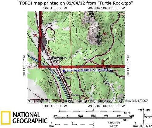
38.88220°N / 106.1477°W |
|
|
Chaffee |
|
|
Trad Climbing, Sport Climbing, Bouldering, Scrambling |
|
|
Spring, Summer, Fall, Winter |
|
|
8460 ft / 2579 m |
|
|
Overview
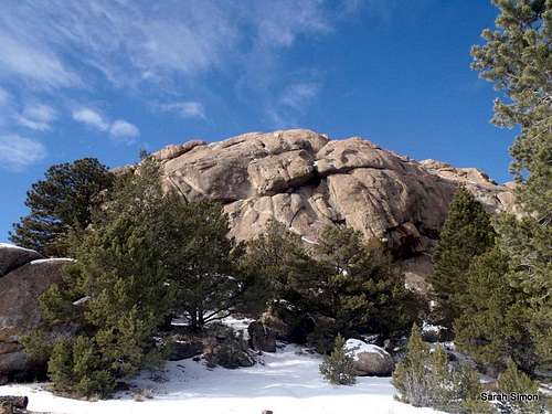
Approaching Turtle Rock
When a “short but sweet” outing is in order, Turtle Rock dishes up exactly what you’re looking for. The various aspects of this nifty granite outcrop feature bouldering, climbing routes and a cool “two-pitch” scramble. The scramble to the top of this neat little rock takes only minutes, but the trip to the top is quite a joy.
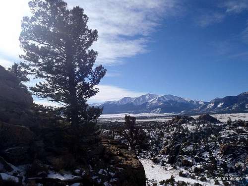
From the summit, enjoy views of the Arkansas River valley to the north and the south. The twin humps of the Buffalo Peaks thirteeners rise in the near northeastern distance. The views up and down the mighty Sawatch range will leave you speechless.
There is little mystery as to how this peak got its name. For certain, when viewed from the east, the shape of a large turtle, head pointing southward down the Arkansas Valley, emerges. The summit area is wide-open, a bare granite viewing platform. Enjoy your stay here in nice weather. Avoid the sheer drops, especially on the east side, in high winds. Kick back, be stunned by the views, and bask in the beauty all around you.
Colorado Rank: Unranked
Prominence: 160 feet
USGS Quad: Harvard Lakes
YDS Rating: Class 4
Rank & Prominence: Lists of John
Getting There
The summit of Turtle Rock sits just 3 miles north-northwest as the crow flies from the town of Buena Vista [BYOOnah Vistuh], Colorado. From the traffic light on U.S. 24 in Buena Vista, turn east onto Main Street. After.2 miles, in the center of old town, turn north (left) onto Colorado Avenue (which becomes Chaffee County Road 371). After about 2.2 miles, CR 371 turns into a graded dirt-road suitable to all passenger cars.
From this point, there are two options for parking and approach:
From the east (turn before the Midland Tunnels and park in the campground)
After traveling 2.7 miles on CR 371, turn east (right) on CR 375 just before the Midland Tunnels. Following this twisting, graded dirt road for 0.8 miles to the entrance for the Turtle Rock Campground. Limited day-use parking may be found near the back (western edge) of the campground.
From the west (continue through the Midland Tunnels and park in a pullout on the east side of the road)
After traveling 2.7 miles on CR 371, pass CR 375. Proceed carefully through the narrow, one-lane series of tunnels. Immediately after exiting the northern-most tunnel, there will be a pull-out on the right side of the road.
 Turtle Rock from the East Turtle Rock from the East |
 Turtle Rock from the West Turtle Rock from the West |
Midland Tunnels
| Why were the Midland Tunnels (originally for railroads) built if there is also room next to the river for tracks? The tracks next to the river belong to the Rio Grand Railroad, while the Midland Railroad owned the tunnels. Read this article Chaffee Country Times article to learn more. |
 Midland Tunnels from south Midland Tunnels from south |
 Peering into Midland Tunnels Peering into Midland Tunnels |
 Midland Tunnels support? Midland Tunnels support? |
 Midland Tunnels Close-Up Midland Tunnels Close-Up |
Scrambling Route
There are 5th Class climbing routes on Turtle Rock, and I hope other members of the SP community will submit a few of these and attach them to this page. I summited the peak via the scrambling route and will describe that route here.
 Approaching the lower weakness Approaching the lower weakness |
 Lower weakness, close-up Lower weakness, close-up |
 Looking down the lower weakness Looking down the lower weakness |
• From either parking area, work your way around the northern base of the rock to locate a weakness in the northern face. The hardest move in the chimney is 4th class. The exposure is very moderate, but simple climbing moves (more careful placement and thought-out planning than just 3rd Class crawling) will be required to move upwards through the chimney.
 View from the western ledge
• Reaching the top of the chimney, access a west-facing ledge (note a large evergreen tree) and traverse across this ledge in a southward direction. Look up to your left/east and note another weakness in the upper, west-facing part of the outcrop.
 Upper weakness Upper weakness |
 Upper weakness, detail Upper weakness, detail |
 Looking down the upper weakness Looking down the upper weakness |
• Ascend this weakness. There is no reason for the climbing here to be more difficult than 3rd class, unless you want it to be. Note: The summit is not what appears to be the highest point to your left, where the more difficult terrain is, so do not bother heading that way unprotected.
• Scramble over a few easy boulders to the highpoint.
Red Tape

UN 9125 from Turtle Rock

Parking area from summit
The day-use parking is for day use only – please do not camp in the day-use parking lot. Likewise, overnight campsite parking is for campers only – please do not hog up camper parking for day use.
Note that this area, despite clean-up efforts, still suffers from quite a bit of litter. Please pitch in and be willing to pick up after some nameless, lazy slob by carrying out a Miller Lite can or Corona bottle on your way back to the truck. (My contribution was removing an empty bottle of Smirnoff Ice from the north chimney.)
| Turtle Rock is used by local outfitters and climbing groups. To manage crowds and help provide a more predictable experience, the BLM publishes a “Turtle Rock Calendar.” Check the calendar in advance of your visit to know, for example, whether an outfitter may be permitted to have a group of up to 30 people on the rock. You may wish to adjust the date of your visit accordingly. |
Camping & Lodging

Northwest from summit area

West from the summit area

North along summit ridgeline

South along the summit ridgeline
There is rustic camping available off of County Road 475 on a first-come, first-served basis. Be certain you are camped on public land.
Turtle Rock Campground
At the base of Turtle Rock sits the aptly named Turtle Rock Campground. My understanding is that the BLM has taken what used to be a rustic, completely unimproved camping area and turned it into an official campground quite recently. The site looks clean and new and some privacy is afforded by the scattered piñon and juniper.
Arkansas Headwaters Recreation Area Campgrounds
The AHRA operates six campgrounds in the Arkansas River valley, two of which are located in reasonable proximity to Turtle Rock. Be aware that these campgrounds are popular with white water rafters in the warmer months and are used as take-outs / put-ins for boaters.
Railroad Bridge Campground
North of Buena Vista on County Road 371
• 14 campsites (each consists of tent pad, fire grill and table)
• Two vault toilets
• Two changing areas
Ruby Mountain Campground
South of Buena Vista on County Road 300 via CR 301
• 22 campsites (each consists of tent pad, fire grill and table)
• Four vault toilets
• Two changing areas
Buena Vista hotels, B&Bs, cabins and commercial campgrounds
A variety of lodging options are available in the nearby town of Buena Vista, skewing toward the simple and affordable. Visit the Colorado Vacation Directory Buena Vista page or the Trip Advisor area guide for more details.
Weather & Seasons
Due to the popularity of this area in the summer with OHV enthusiasts, visit this peak in snow season if quiet and solitude are desired.
 Click for weather forecast |
Fall: Autumn would be a perfect time to visit this peak, when the Aspen are ablaze in bright golds against the blue Colorado sky and the summertime crowds have begun to wane. Be mindful of elk hunters in the area and wear bright colors for safety. Winter: Turtle Rock is a fun and quiet place in snow season and the views of the snow-covered Sawatch are amazing. Be mindful, however, that slick snow or ice can up the ante at tricky scrambling pitches. Spring: Spring will no doubt be muddy, though this area will melt out much earlier than the higher country across the valley. Summer: This lower elevation area east of Buena Vista gets somewhat hot and sun-baked compared to the high country to the west, but this could be a good acclimatization hike for visitors from lower elevations wanting to tackle higher goals later in their visit. Be forewarned that this is a popular OHV area in the snow-free months. |
 Click for weather forecast |
External Links

Après-scramble at Eddyline in Buena Vista