
|
|
Canyon |
|---|---|
|
|
37.23560°N / 112.64146°W |
|
|
Canyoneering |
|
|
Overview
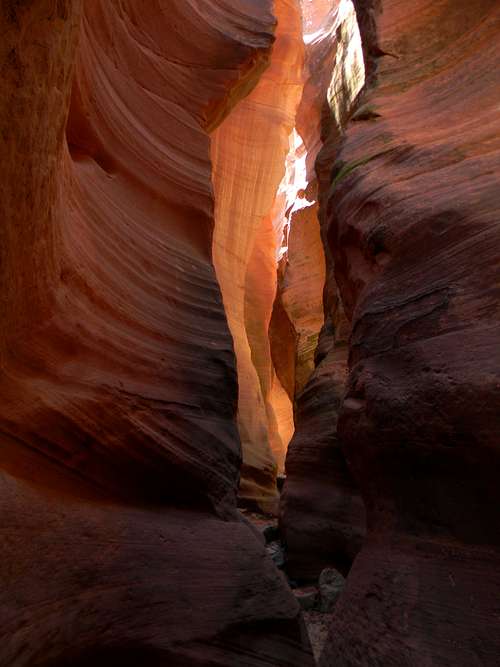
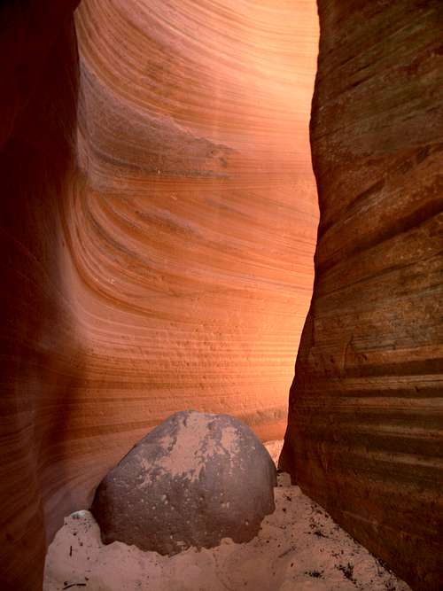
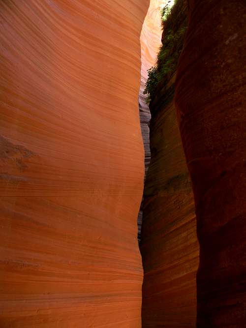
Lower Red Cave
Upper and Lower Red Caves are two beautiful slot canyons east of Zion National Park in southwestern Utah, located just east of Mount Carmel, Utah. Because they are so close to each other, many people will visit both canyons on the same hike.
They are not the same thing as Red Canyon, another nearby slot, although all are composed of striking red Navajo sandstone. Being at the fairly high elevation of 5,500 feet, they are often wetter than many of the other slot canyons in southern Utah, and will frequently have deep pools and mud within them.
The Upper canyon is not technical, although it does has a number of steep drops, including one of about 10 feet in the lower extent of the feature.
The Lower canyon has two drops of about 40 feet each, separated by a 40-foot level section about midway through the canyon. There are bolted anchors at each of the drops, and when I was there, there were highly rotten knotted ropes dangling down each of these drops.
It is possible to ascend this canyon to these barriers, return to the exit of the canyon, and then take a bypass to the southwest of the river course and drop down into the canyon above the narrowest stretch and by descending down to the drops see nearly the entire canyon without bringing technical gear.
Zion National Park.com rates Upper Cave 3B II and Lower Cave 3A I in terms of technical difficulty.
Getting There
ACCESS UPDATE - Scott reports that the access from Tait Lane is currently CLOSED. Access is possible from the south but the hike is considerably longer. Zion National Park.com states that you need written permission from the Tate family as noted below.
These Canyons are located to the east of Rt. 89 at Mount Carmel approximately 2.5 miles north of the junction of routes 89 and 9.
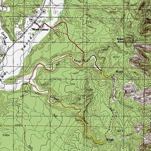
- The Dark orange is the access walk from the highway to Sand Wash, with a dashed line shown for an alternate variation- The burgundy color is the approach to the Upper Cave along Sand Wash- The lighter orange is the approach to the Lower Cave along Sand Wash and then Lower Sand Wash.- The Dashed lighter orange is the bypass of the steep drops within Lower Red Cave- The Yellow is represents the slot canyons. The Lower Canyon is not a continuous deep slot this entire length.- The Dashed Purple is a route that can be used to make a loop of a bit over 7 miles to both canyons.
Walking Directions:
This is how i got there but may no longer be valid... - Descend Tait Lane a couple of hundred yards to a stream.
- Cross the stream and then follow the road first northeast then southeast to a gate at a gravel pit.
- I then walked northeast past another gate and then followed a dirt road for about a quarter-mile as it angled up the hillside.
- At this point, the road turns to the southeast and keeps this general direction for about 3/4 miles (taking a left fork shortly after passing through a gap in a fence) to where a view of Sand Wash is seen.
(Alternately, some people have passed the gravel pit on the south side, striking directly up the hillside angling left at a fork in this road, joining up with the above route just before the fence.)
- At the Sand Wash view, there is a four-way junction. Continue southeast, descending down into Sand Wash in 0.3 miles.
Upper Cave:
- Just before the wash, there is a fork in the road. If you are going towards the Upper Cave, turn left, descend to the wash and follow it upstream for about half a mile to the canyon.
Lower Cave:
- If you are going to the Lower Cave, turn right at the fork, descend to the wash and follow it for 1.4 miles to where a side wash comes in from the left. Along this stretch, there might be a "No Trespassing" sign. Most sources that I have seen have indicated that it is okay to continue if you stay within the wash on the private land.
- Turn left and ascend Lower Sand Wash for about 1.2 miles.
- Go right when a tributary wash comes in from the left and walk another 0.2 miles to the entrance of the Lower Cave.
- If you are doing the loop hike, it is recommended that you visit the Lower Cave first.
The Canyons
Lower Red Cave
Upper Cave:
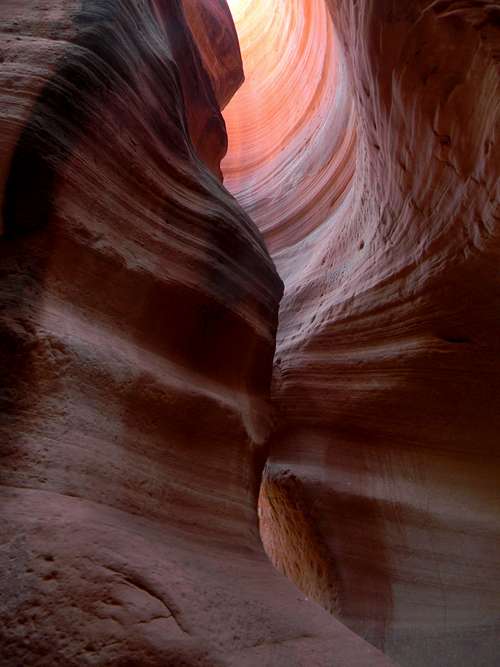
As a matter of personal opinion, the upper cave is one of the most beautiful places that I have ever been to. Ascending from Sandy Wash, you enter into a deep slot as the stream passes through the Navajo Sandstone. After a brief distance with several short climbs, there is a significant 10 foot or so step that might take some scrambling skills to pass. After this, the canyon bed ascends more gradually, briefly becoming less dramatic, and then entering a deep area of phenomenal beauty. Eventually, a small wash can be seen dropping in from the right (that followed on the loop hike) and after another 70 feet or so to the left, the canyon opens up.
Lower Cave:
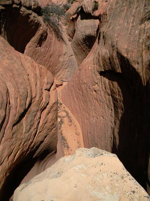
It is possible to climb up several hundred feet through quite spectacular canyon scenery until a steep slab is reached. When I was there, there was a knotted rope (that might or might not have held body weight) dangling down from an anchor above at this point. Any use of this or a similar rope would have to be at your own risk... Just beyond this point is a steeper wall, so most sources recommend stopping beneath the lower slab and descending out of the canyon.
At the exit to the canyon, there is a steep sandy slope climbing the hillside to the west with obvious foot travel upon it. To continue the canyon tour, climb this steep slope for 250 feet or so, keeping right and directly up the slope until a use trail is reached along with nice views of the vicinity.
The trail turns left here and traverses along the top of the canyon in a southeasterly direction for about 250 feet where it crosses a sandy ridge. Follow the ridge south for 40 feet and then continue on the trail for a few hundred feet until it descends down into the wash. Be careful here, there is a lot of steep terrain.
Carefully descend back into the Lower Red Cave. About 10 feet from the bottom, the downclimbing becomes dicey enough that you could either use a rope or make a short drop into the streambed. Exit back the way that you came here would be difficult, so if you are doing this, it is likely best to do the loop hike.
Prior to continuing up the canyon, descend the watercourse downward to the top of the two drops mentioned above. Don't miss this part as it is really pretty!
- You might want to bring a short length of rope to belay people or lower people down the drop into the upper part of Lower Red Cave. In addition, the descent of the Lower Red Cave would require a 120 or so foot rope, maybe a few anchors, or luck that some really old and ratty in situ ropes don't break while you are weighting them.
Wash above the Upper Cave
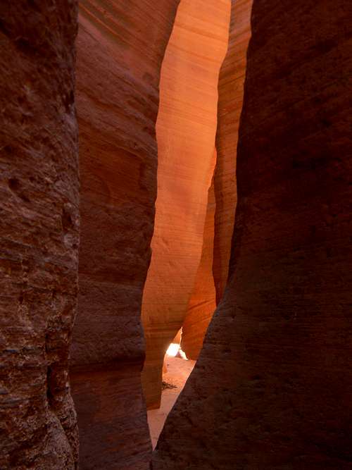
Upper Red Cave
Loop Hike:
From the point where you re-enter Lower Red Cave, once you have checked out the slot below, proceed up the canyon for about 0.4 miles, then climb the hillside on the left (north) side to exit out of the wash.
It is also possible to leave the wash after about 0.25 miles, climb past a rock with a small hole in it, and continue up the hill to a small summit. From the vicinity of this summit or the saddle behind it (see map above), contour in a northerly direction to the west of a higher summit, eventually reaching a defined ATV trail. Either follow this for a bit north or continue north past it, descending down into a pretty wash with smooth slickrock walls. There are a few points of scrambling here.
Once in the streambed, follow this nice watercourse about 0.3 miles until Upper Red Cave is reached. At the junction, it is possible to set up a rappel and descend directly from this spot. It is likely easier to climb up and north about fifty feet to crest a ridge, then contour along the slope still in a northerly direction for another couple hundred feet and eventually drop west and down into the Upper Red Cave watercourse. Descend this back south a couple of hundred feet to the junction and the topmost reaches of Upper Red Cave.
Extra Credit:
There is a cool looking red and then white rock dome just beyond the end of Upper Cave. I didn't do it, but and ascent from here would probably be a blast and give nice views of the area.
Safety
Being slot canyons, make sure to never enter these when rain is threatening or falling anywhere within the watersheds.
In addition, some sections of the hikes described include walking in exposed places where a fall could be unfortunate, so be careful...
Red Tape
- Although the canyons are on public lands, you must cross private land to access it, so you should get permission from the Tait family whose address is 2410 on Rt. 89. They are quite nice, and I had a long and pleasant conversation with one of the family members when I stopped by.
Camping
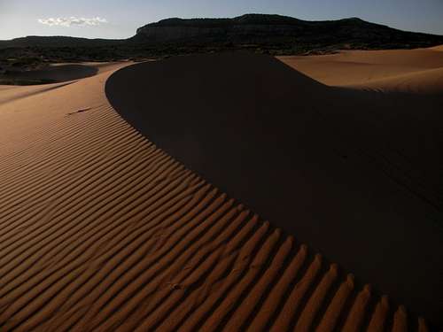
Coral Pink Sand Dunes
There are several places to camp nearby, being largely surrounded by public lands:
Zion National Park is about 15 miles to the West along Route 9. There are a number of camping options here, although they are quite a bit beyond this eastern park entrance.
Coral Pink Sand Dunes State Park is located some 18 miles to the south and has camping for roughly $15. From Carmel Junction, head south on Rt. 89 for 5 miles, and then turn right at the sign for the dunes. Drive 12 miles south to the park which can be entered (for a fee) on the left. There are 22 spots in the campground. Places can be reserved here.
Ponderosa Grove Campground is also roughly 15 miles to the south, accessed by turning left on Hancock Road from the road leading to the sand dunes. You can also access the camping by driving a bit more than 7 miles north on Rt. 89 from Kanab, and then left on Hancock road for 7 miles. There are 9 spots with a fee of $5.00 although water is not provided.
Much of the surrounding terrain is BLM lands. Information about camping on it is found on this website. A permit that can be obtained in the Kanab Visitors Center (756 East Highway 89, about a mile east of the junction where Rt. 89 turns to the East) and is required for backcountry camping. It is requested that you only camp where there is previous evidence of a campsite.
External Links
Upper Red Cave
Upper Red Cave
- BluuGnome has a thorough and complete description of the canyons at its website. The page provides all details about the hike, the canyoneering, and a bevy of pictures if you click the link. It also provides a whole bunch of GPS Waypoints describing the loop hike for people who use this technology...
- Zion National Park has included a description of the Caves and loop hike on this page.
- The Circle of Friends also has a webpage of the canyons.
- Find the Cantoneering.net forum about the canyons and access issues here.
- Bogley has a nice forum on nontechnical slot canyons in the area here.
- There are a couple of YouTube videos of the canyons. An ascent of the Upper Cave can be found here taken under somewhat wet conditions. This video wanders a bit but has a nice segment with the rappels in the Lower Cave at 7:00.
Jason Abbott - Mar 19, 2024 8:58 pm - Hasn't voted
Phone number given for Taits is no longer validI called the number for permission to cross private land and the elderly sounding lady explained, "We don't have anything to do with that anymore. I wish I could take our number off the web." She suggested visits to the caves are now handled by East Zion Adventures. Looking at the EZA site, I would guess it's the tour they call Crimson Canyon. Details seem to match up. I plan nonetheless to swing by the turn-off tomorrow to see what signage might indicate. I'll update again with anything new.
RobSC - Mar 19, 2024 9:25 pm - Hasn't voted
Re: Phone number given for Taits is no longer validThanks for the update, Jason! I took the phone number off. If you do learn about the current access, please report this. The Canyons are amazing. I hope that you get to see them!
Jason Abbott - Mar 24, 2024 11:37 am - Hasn't voted
Re: Phone number given for Taits is no longer validMy daughter and I turned onto Tait Road but stopped at the creek crossing so can’t report on any gates or signage beyond that. (Not a big creek but muddy and maybe up to a foot deep — easy on another day but not two-up on a big motorcycle with luggage). Looking up the road beyond the creek, I saw no signs or gates that would have stopped us otherwise. I also didn’t see a lot of tracks on the road to suggest it was heavily used, for example, by East Zion Adventures. There were just a few automobile tracks crossing the creek.