


PAROFES - Apr 22, 2010 2:00 pm - Voted 10/10
Interestingalbum! Great idea!
Cheers

peakhugger - Apr 27, 2010 1:47 pm - Voted 10/10
Excellent collectionThanks for taking the time to put these images together in one location!

ScAtTeRbOnE - Nov 20, 2010 9:22 pm - Voted 10/10
Survey MarkersIt's interesting to see all the different types of markers in different conditions.

vanman798 - Nov 22, 2020 12:50 pm - Hasn't voted
Terminology....Great idea, and a fun photo album to look at.
Thanks for posting this.
As I read more and more on this topic of Survey Marks I find again and again that the terms are not defined hard and fast. Which makes it confusing. Some of it might just be a matter of terms being used colloquially in one situation and formally in another.
With that said, I think it is worth noting though, that strictly speaking a lot of the metal disks in the photos are not bench marks.
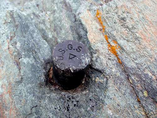
Here is what my other reading seem to agree on: A primary survey mark is a point on the earth for which an accurately measured location, either horizontally or vertically has been determined. Additionally other survey marks (non-primary) are disks which point to a primary mark, and these are known as Reference Marks. Both types of marks use the same sized disks, made of either bronze or aluminum, and stamped with text, numbers, and a symbol.
Vertical control marks are those for which a measured accurate elevation above sea level has been determined, and they are stamped at the center with a crossed slash symbol. Disks stamped with an equilateral triangle symbol in the center are horizontal control marks and they pinpoint a spot for which the latitude and longitude has been accurately calculated. Reference Marks are stamped in the center with a crossed arrow symbol, and are always set with their arrow symbol accurately pointing toward a primary mark.
Survey marks are known by various other names, such as monuments, points, bench marks, and stations. These names might also be proceeded with terms like survey, horizontal control, control, or triangulation – as in “triangulation station”. There are technical reasons for these names, but surveying is a complex discipline and terms end up being used interchangeably even if not strictly correct. For example, a bench mark is a point of precisely measured elevation, but some might call a monument concerned only with horizontal positioning a bench mark since they are both marked with metal disks. Whereas technically monuments concerned only with horizontal positioning are called horizontal control stations or simply control stations. A Triangulation Station is a specific type of a control station having had its position determined by measuring distances and angles from other stations. An Azimuth Mark is a long Reference Mark. Unlike a normal Reference Mark which is typically located within thirty meters (one tape length) of the primary mark, Azimuth Marks are set typically between one quarter of a mile and two miles from the primary mark, give or take.
Reference Marks, including Azimuth Marks, serve two purposes. First they provide a point from which a surveyor can locate a primary mark. Once the primary mark is found and the surveyor sets up his gear in order to make accurate measurements he needs a known point of reference, and that then is the second function of both types of Reference Marks – they allow the surveyor to know the exact direction in which he is looking.
One more point worth noting. Survey Disk are not typically concerned with being place on the highest point. They are set so as to be visible which means often they are at, on, or near the highest point which ever is the most visible.
I believe the ational Geodetic Survey did most of the surveying of the USA. They have the NGS database. https://geodesy.noaa.gov/
The guys that make maps, USGS placed survey disks for awhile too.
In the comments section of "https://www.summitpost.org/on-bench-marks-history-purpose-and-a-mountaineer-s-perspective/comments/613557/p2 by Survey1989" I read this " In a nutshell, USGS uses a generic 'monument' type for all its surveys,
with 'benchmark' or 'BM' embossed on the 'monument'. On the other hand, USC&GS/NGS uses 'monuments' embossed with a
specific purpose in mind such as 'traverse station', 'triangulation station' (classical horizontal control), 'benchmark' (classical vertical control), etc."
Anyway, hope you find the above information helpful.

gimpilator - Nov 23, 2020 7:37 am - Hasn't voted
Re: Terminology....Thank you! This is a lot of excellent information. I have wondered about the various differences in style and symbols. Many of my questions were answered by your comment.
vanman798 - Nov 23, 2020 4:10 pm - Hasn't voted
Re: Terminology....The most complete source I have found on this topic can be found at https://www.ngs.noaa.gov/web/about_ngs/history/Survey_Mark_Art.pdf
Comments
Post a Comment