
-
 11032 Hits
-
 71.06% Score
-
 1 Votes
|
|
Route |
|---|---|
|
|
38.46330°N / 109.2332°W |
|
|
Hiking, Scrambling |
|
|
Most of a day |
|
|
Class 2-3 |
|
|
Approach
From the Burger King in Moab, drive 7.4 miles to a junction with a road called La Sal Loop. Drive up the La Sal Loop road for 12 miles, then take a dirt road on the right going to Geyser Pass. Drive on this for 5.55 miles and take a right onto a smaller dirt road. Follow this another 1.65 miles to the end. A trail heads off from the road here.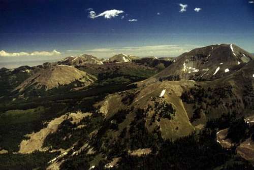
Route Description
Distance: Approximately 7.89 milesTotal Elevation Gained: 5,030 feet
Time: It took me about 10 hours
This route includes the Razor Fang traverse listed on the Mt Peale page. Photos of this route are found on pages corresponding to the peaks shown in them.
There are two variations to begin the route which meet up on top of peak 12048.
Variation 1: Begin hiking on the small trail that spurs off from the end of the dirt road. Follow the trail downhill, but as it turns to the left, continue walking downhill in the clearing to the stream. Ford the stream and walk up the clearing heading southeast towards peak 12048. From here, continue scrambling up the talus field and scramble up a steep slope of loose talus and scree to gain the ridgeline. There is usually some thin patches of snow that run up most of the slope well into summer, and these make the route much easier.
Variation 2: Stay on the trail that starts at the road, and follow it as it turns east and ascends into Gold Basin. As the trail begins to enter some clearings and the surrounding peaks are visible, you'll be able to see a prominent gouge in the hillside below peak 12048 that goes all the way down to the boulderfield. Scramble up this gouge to gain the steep meadow slopes above, and keep hiking slightly to the right until the ridgeline is gained. This route is nicer than the first variation when snow isn't present since the ground is much more stable.
From the ridgeline, scramble up to the summit of peak 12048 (Little Tuk) and continue on the ridgeline to the top of Mt Tukhunikivatz. Follow the ridgeline over to Mt Peale. There is a short section called the Razor Fang that must be negotiated. If one climbs to the right, staying low, the loose scree below can be avoided while the scrambling never gets above low class 3 (assuming one doesn't wander too far to the dropoff in the north side).
As the junction of Mt Tukhunikivatz, Mt Peale, and Mt Mellenthin is gained, a slight trail will be visible leading towards Peale. From here Peale can easily be hiked. Make sure to return to the junction, and follow the northward spur towards Mount Mellenthin. Hike over the two peaks on this ridge (one is pk 12271, the other has no label) and scramble up the prominent south ridge of Mt Mellenthin. If one stays near the cliff on the ridge, the rock stays more solid. There are some faint trails that switchback up this scree slope, and the summit is easily gained.
Head back down the ridge towards peak 12271. From the saddel between 12271 and Mellenthin, a faint trail can be seen traversing a little below the summit of peak 12271. Follow this trail as it goes right and travels down a west-facing ridgeline. From here, it is easy cross country hiking to treeline, making sure to stay on the top of the ridge. At the last mound on the ridge, make sure to take the branch heading right and go down the shallow gully that forms on this part of the ridge. The hiking below treeline is easy, with little or no bushwacking. Eventually, if one stays close to the bottom of the gulley, a stream is reached, and then a clearing with a faint 4X4 road. Follow this road a few hundred yards to where it joins a larger dirt road (you drove in on this one). Turn left and follow the dirt road another 100 yards or so back to the trailhead.

Essential Gear
Good hiking boots, camera, food, plenty of water (no places to refill on the route!). An ice axe and crampons can be helpful for walking on the snow, which is often desireable when it is present.