
-
 8309 Hits
-
 72.08% Score
-
 2 Votes
|
|
Route |
|---|---|
|
|
42.21660°N / 9.05370°E |
|
|
Hike and Scramble |
|
|
Most of a day |
|
|
KS1-C |
|
|
Approach
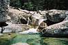
One of the most beautiful valleys of Corsica, Maganello is some 15km of cascades, waterfalls and rock pools. You can reach it from Route Nationale 193. Between Tattone (south) and Vivario (north) a narrow little side road (D23) heads east into the Manganello valley. The trailhead is at the very end of this road at Canaglia.
Route Description
Altitude gain: 1855m
Duration: 5h
Difficulty: I+ (only at the summit)
Trailhead: Canaglia
The manganello Valley is one of the most beautiful valleys of Corsica. It follows Manganello creek, which for most of the time is an endless sequence of waterfalls, cascades and corresponding rock pools. In summer you will certainly take the opportunity to take a bath so that you should do the ascent in two days rather.
From Canaglia follow the dirt road through the valley. Most of the trail is an easy hike only at the end of the valley you need to do some scrambling to reach the Refuge Petra Piana. From the lower parts of this ascend Monte Rotondo is almost always visible. After 3h 15min you reach the high plain near Bergerie de Gialgo at 1610m, after another 45min you're at Petra Piana.
The further ascend heads upwards to Lago Bellecone (2519m) and from there into the pass left of Rotondos Summit block. Here an exposed scramble (I+) leads you to the summit with the summit bivouac.
 |  |  |
Essential Gear
Hiking gear and warm clothes are neccessary. Since there often is snow in the couloir, that leads to the summit ridge - even in late June - crampons might come in useful.
Flachlandtiroler - Jun 19, 2006 11:24 am - Hasn't voted
Western approachApart from the GR20 (which the most people climbing Rotondo surely use) and the approach via Manganello Valley as mentioned one also can access the Monto Rotondo south side and Petra Piana hut from the west. From the Golf of Sagone it is a one hours drive via Vico and Guagno=les=Bains to Guagno (Gîte d'Etappe). The road continues several km upwards and changes into a gravel road just behind a garbage dump. Several hundert meters ahead the trail starts and a signpost mentiones the Bocca Mangenello. Altitude about 1000m. The path decends close to the river, several serpentines can be cut short. Contouring at about 900m meters above the river it leads through beautiful forests to an abandoned bergerie under big lariccio pines. The Bocca is already visible and reached through open terrain, i.e. sun-exposed. 3-3.5h from the start. Here one joins the GR20 an the hut is visible shortly afterwards. A half hour of scrambling with little up and down and one stands in front of Refuge Petra Piana.