
|
|
Route |
|---|---|
|
|
44.06530°N / 73.7578°W |
|
|
Hike/Scramble |
|
|
Most of a day |
|
|
Class II |
|
|
Approach
Park your car at the unofficial trailhead where the North Fork of the Boquet River runs under a bridge occupied by NY Route 73. The paths from Route 73 to the summit of East Dix are unmarked and not officially maintained. Begin on the south side of the North Fork of the Boquet River where there is a nice herd path. After less than ten minutes, the path descends to stream level, where there is shortly a herd path across on the north side of the North Fork of the Boquet River. Continue on this herd path and it will move a bit further away from the North Fork of the Boquet River where it then crosses a very small stream that is the outlet of Round Pond. After this, the herd path gets closer to the North Fork of the Boquet River again. In a few more minutes, this herd path crosses the North Fork of the Boquet River, leaving the North Fork for good and ascends some small hills. There is a short side path to Lillypad Pond. Eventually, the herdpath reaches the South Fork of the Boquet River and parallels it for around forty minutes before reaching a campsite where the drainage from the Dix cirque comes in. Cross this drainage and continue following the South Fork of the Boquet River. Sometimes you will be rock hopping in the stream or on islands in the midst of the stream. Eventually, the herd path crosses the South Fork and is then on the south side of the South Fork. It quickly ascends and leaves the vicinity of the South Fork. You will then come upon a rock slide on the left of this herd path. Do not go up this slab, because there are two slides and this first one does not have a nice exit and the top; instead you must contend with thick cripplebrush at the top. Continue on the herd path for another 5-10 minutes until you come upon another rock slide. This second one is the Great Slide of East Dix.
 |  |  |  |  |
Route Description
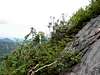
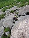
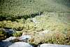
This is a great beginner slide by Adirondack standards. Use your better judgment as to what route to take up this slide. You can make it harder or easier. Stay away from wet rock as it can be very slippery. Plan your route ahead so that you do not have to cross wet rock! Generally, the easiest route on this slide as you ascend is to the right in the bottom third of the slide, to the left in the middle third of the slide, and to the right in the top third of the slide. The easiest route can be distinguished itself as sort of a herd path in portions of this slide. As you look up the slide, a large rectangular-shaped nub should be your target as you ascend. Once you reach the top of this slide, the true summit of East Dix is a short 5-minute walk on herd paths to your right. This slide has an average grade of 35%, and can also be safely descended.
 |  |  |  |  |
Essential Gear
Map, Compass, Dry Weather, the book "Discover the Adirondack High Peaks" by Barbara McMartin.
Miscellaneous Info
If you have information about this route that doesn't pertain to any of the other sections, please add it here.