
|
|
Route |
|---|---|
|
|
38.67420°N / 106.2464°W |
|
|
Hiking |
|
|
Summer, Fall |
|
|
Most of a day |
|
|
class 2 |
|
|
Overview
This is the standard route to climb Mount Antero. Most of the route may be driven with a high clearance, 4WD vehicle, or the entire 6-mile route may be ascended on foot with no problem. The route starts near the bottom of Baldwin Creek, above 9300' elevation. If hiking, you must share the trail (road) with 4x4's and ATVs. Enjoy!Twelve miles round trip, and 5100' elevation gain.
Approach
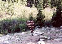
 Baldwin Creek
 Summit view from the west slopes
To get to the trailhead, turn west onto Chaffee County Road 162 from U.S. 285, 6 miles south of Johnson Village. If you are coming from the south, the turnoff is about 16 miles north of the U.S. 285/U.S. 50 intersection in Poncha Springs. Go west on the County Road 162 (paved) for 12 miles to the Baldwin Gulch Road (dirt). Park at this junction. With a 4WD vehicle you may proceed 3 miles southeast on the Baldwin Gulch Road to a parking area at 10,840', or even further.
Route Description
 Road forks here
 Weather's comin'
Follow the road southeast and south up the Baldwin Creek drainage, through pleasant, forested land. At about 3 miles (10,840') the road will fork. Take the left fork, which heads upward into Baldwin Gulch proper.
At 12,000' the road begins to switchback up Antero's west slopes. If you are on foot, you may cut off a lot of mileage by climbing straight up the slope to join the ridge about a half mile south of Antero's summit. The road will lead you to approximately the same point by a more circuitous route. Once on the south ridge, continue north for one half mile to the summit. A good trail leads you through the push to the summit.
Essential Gear
[img:49741:alignright:small:Heading down][img:209170:alignleft:small:Weather's comin']No special gear is required. As with any high mountain in the Rockies, you must prepare for any weather, including freezing cold, high winds, wet weather, even in mid summer.
WeaverB - Jan 17, 2014 8:08 pm - Hasn't voted
Mount. Antero, COCorrection for: Mount. Antero Elevation 14,269 Baldwin Gulch Trailhead / West Slopes (standard route) 1. From North or South on U.S. Highway 285. 2. West on County Road 162. 3. Parking at Country Road 162 and Baldwin Creek Road or Four Wheel Drive Road 277. 4. South on Baldwin Creek Road or Four Wheel Drive Road 277. 5. Left or South on Upper Browns Road or Four Wheel Drive Road 278. 6. Left or West on Four Wheel Drive Road 278.B 7. Left or North on Four Wheel Drive Road 278.1A 8. Drive to the end of Four Wheel Drive Road 278.1A to the Trailhead.