
-
 3952 Hits
-
 71.06% Score
-
 1 Votes
|
|
Route |
|---|---|
|
|
39.83400°N / 77.494°W |
|
|
Hike (Class1) |
|
|
Half a day |
|
|
Walk-up |
|
|
Approach
Follow the directions in the "Getting There" section of the main page.
Route Description
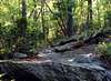
This route starts at the southern end of the ridge which contains Buzzard Peak and Snowy Mountain. The trail climbs steadily past the Tumbling Run Shelters up the ridge. The path is marked well and it's easy to see where you need to go. Th trail climbs past the ravine which separates Buzzard from Briar Mountain. It is a steady ascent all the way up to where the trail splits on the flats near the top. The trail to Chimney Rocks and the summit heads south and is marked by blue blazes instead of the normal A.T. white. From here you can elect to head out to Chimney Rocks. Then get back on the A.T. The trail then continues with little elevation gain for 2 miles. At one mile from Buzzard Peak you will cross the pipeline which gives som nice views of Green Ridge. Continue on until you get to the powerline cut for one more mile. From here it is a short hike up the powerline to the summit tower. The total roundtrip distance is 7 miles, with an elevation gain of 1062 feet. The views are wonderful and it's a great place to check out wildlife.
 |  |
Essential Gear
A day pack with food and snacks. Wear comfortable shoes to hike in.
In snow and ice conditions you may need crampoons.
Miscellaneous Info
If you have information about this route that doesn't pertain to any of the other sections, please add it here.