
|
|
Route |
|---|---|
|
|
18.12497°S / 69.12735°W |
|
|
glacier climb |
|
|
A few days |
|
|
PD |
|
|
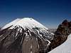
Approach
Approach from the Sajama village heading west, rent a 4x4 or a donkey (1,5 hours by 4x4, 8hours by fet with donkey) to reach the base camp at 4700m. from here, the volcanic ashes get too deep for the car to preoceed. walking is also harder. from the basecamp, head towards the Col between Parinacota and POmerape to reach high camp at 5200m.
 |
Route Description
From the col, you can climb the south face broad culoir (snow covered with no or little crevases and not too steep - up to 40 degrees) until 4/5 of the rocky ridge on the left. cross the ridge and you will get to another culoir. this one is steeper, glaciated with crevasses and seracs in the upper part. The inclination gets up to 55 degrees. narrow culoir on the righthand side will lead yout onto the S (or perhaps SE) summit which is 50 m. lower than main summit. descent via the same route. We did this with ski mountaineering equipment and skied down in september 2004, see http://skicordillera.laviny.cz , click on the GB flag and click on diary to read expedition diary.
 |  |  |  |  |
Essential Gear
snowstacks (snow anchors), rope, 2 icetools at least for the leading climber, crampons, harness... lot of water as the snow in the lower parts of volcano is mixed up with volcanic ashes...
sunscreen a must!
Miscellaneous Info
If you have information about this route that doesn't pertain to any of the other sections, please add it here.
tatraman - Apr 20, 2005 8:11 am - Hasn't voted
Route CommentTake into consideration, that south faces are the ones that get less sun in the southern hemispere.Hence they are colder. The coldest face of a mountain to be at early in the morning is probably SW face in this part of the world