
|
|
Route |
|---|---|
|
|
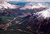
46.36390°N / 122.1023°W |
|
|
Hike |
|
|
Half a day |
|
|
Class 2 (some Class 3) |
|
|
Overview
This is a good shortcut route to the West and Middle summits of the Goat Mountain ridgeline. The climbing makes use of an old overgrown road and/or an open forest band to climb all the way up to meet the Goat Mountain Trail immediately below the top of the Middle Summit (Pk 5400+). Though it starts approximately 300 vertical feet lower than the Goat Mountain Trailhead, it is quite a bit shorter in terms of terrain distance. By way of the trail from Ryan Lake, the distance to the Middle Summit is about 3 miles. By way of the shortcut, the distance is about 1.5 miles. Doubling these values to include the return trip, you can see the shortcut saves 3 miles in total (that's an hour or more of hiking).
Getting There
As per the Goat Mountain Trail approach described on the main page, continue west down FR-2612 past Ryan Lake (3,200 ft). In exactly 1.5 miles from the junction of FR-26 and FR-2612 there is a short spur on the left (south) side of the road leading down toward Green River.
Forest Band Start
Maybe about 30 yards farther down the road on the right (north) is a short "road" that leads to a brushy cleared area amongst bigger trees (Topozone location). Park here (elevation ~2,900 ft). The forest band is only modestly brushy up from the road for the first few hundred yards. The brush doesn't impede progress. As such, this start point is probably better than the overgrown road start point.
Overgrown Road Start
Continue west down FR-2612. In about 1.7 miles (from FR-26) the road will come to a fork. Keep right. At about 200 yards past the junction there is a spur road going off to the right (Topozone location; note that the spur is not shown on this map). This is the second spur on the right (ignore the one immediately after the road junction). The correct spur is bermed about 30 yards back from the road and makes a bend around to the right (northeastward) beyond the berm. If you look close on the right in a tree near the berm you will see a brown sign reading spur 635. Park at this spur (elevation ~2,880 ft).
 |  |  |
Route to Middle Summit
If your start point is the forest band, simply ascend directly up it for 2,200 vertical feet until you hit the Goat Mountain Trail, which contours across the south slope of the Middle Summit at approx. 5,000 ft. The forest is mostly open though there are windfalls here and there. We kept to the left side of the band where it butts up against a regrowth area.
If your primary or first objective is the Middle Summit cross the trail and continue up to the crags that make up the south side of the peak. Two or three gullies bypass the crags. However, there is a walk-up route on the west end (West Ridge) and also the east end. Class 2.
From the Overgrown Road Start
Walk the road (often teeming with alder) as it curls first rightward (NE). Be careful you don't miss the first switchback. It comes right at a washout slope with a stream at the other end. At the third switchback the road meets the forest band for the first time (c. 3,200 ft). You can cross a minor gully into the forest (recommended) or continue up the road for two more switchbacks to where it meets the forest again (c. 3,800 ft). At this point it is definitely recommended that you cross rightward (again through a minor gully) to the forest as the road continuation is of unknown terminus or character.
 |  |  |  |  |
Route to West Summit
Note: The West Summit is triangulated at 5,407 ft. The Middle Summit is 5,400+ ft. (The East Summit is Pt. 5106.) Technically, then, the highest point is the West Summit. Fay Pullen and I used a clinometer to measure up each summit. We found that the West Summit was 2 degrees lower than the Middle when measured from the Middle. At the distance between the peaks (one mile), 2 degrees equates to 185 feet. Clearly, Earth curvature considerations have to be factored in. I have not yet made these measurement corrections.
At any rate, to get to the West Summit, follow the Goat Mountain Trail westward to the 4,980-ft saddle between the peaks. Leave the trail and continue up the ridge as it curls around to the summit. There is one 100-ft Class 3 section to deal with on the ridge (by way of a traverse of the south side of the ridge rocks about 30 feet below the crest). The rest is easy.
Time = 3-4 hours from the road to the West Summit; Gain = 2,600 ft; Distance = 2.5 miles.
Descent
Reverse the route. Don't try to go off the south side of the West Summit to reach the road. Blowdowns from May 18, 1980 litter the slope and you'll be cussing at your predicament.
 |  |  |  |  |
Essential Gear
No special gear; although ice axe and snowshoes might be nice in wintery conditions.
 |