
|
|
Route |
|---|---|
|
|
45.27300°N / 14.96200°E |
|
|
Hike with some scramble |
|
|
Half a day |
|
|
Walk-up |
|
|
Approach
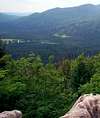
Bjelolasica is, basically, a 6km long ridge stretching NW->SE.Siljevaca is the sixth km.
1132m high rocky limestone group at the SE end, topping the surrounding woods.
Because of its location, it does offer nice views toward mt. Klek on the north,
as well as toward Bijele stijene rocks on the SW.
One can get to base of the climb by Ogulin-Bjelsko-Jasenak paved road. Once in Jasenak village,
turn right following the Samarske Stijene/Bijele stijene roadsigns (signs are clearly visible, made of wood, signed w. white color letters).
It is a nonsurfaced forest road, winding uphill through the woods.
After 4 miles or so, at the sharp left curve, main road connects with nonsurfaced 5km long road
coming from the Gomirkovica ski resort. Youll gonna see this junction clearly, road from Gomirkovica is on your right
and closed with the ramp (traffic not allowed).
This is 1st choice spot to start climbing.
Other one is to proceed by foot via abovementioned road toward Gomirkovica for 200 hundred metres or so, then left uphill.
Going by foot all the way:
--From Jasenak village, follow the marked path Jasenak-Begova staza.
At Tjesanac, trail meets abovementioned nonsurfaced forest road.
From here, one has to go downhill toward Jasenak for several hundred of metres,
then left uphill into the woods.
--From Vrelo, you have two options:
1...Either walk or drive down the paved road toward Jasenak, untill a marked trail of
Vrelo-Vrelce-GuvnoRusov jarak-Bijele stijene route takes you rightbound and off the road.
From here, by foot only, follow the marked trail, soon it takes you to the small forest lodge,
with water spring, woodden benches etc. Further uphill the steep carriage road.
Siljevaca is on your right, you can start hiking up anywhere between Guvno and Tjesanac.
2...Vrelo, 2nd option: cross the road, and start hiking up the trail for Gomirkovica plateau.
Trail follows ski chairlift, therein orientation is easy. On your left, youll see nonsurfaced road ging left.
Thats the one that connects ski resort with Jasenak-Bijele stijene forest road (5km long, ramp at the end...remember?).
This approach is most suitable if you plan to get there by mountain bike
 |  |
Route Description
Not much to describe here.There are no marked routes or trails to Siljevaca rocks.
Main idea is to get as near the base as possible (see above chapter) and find suitable spot for scaling.
Check your compass, if starting from the ramp on the forrest road for Gomirkovica,
you should scale through dense forest, direction NW. Taking it up earlier from the same road,
scale up direction W. In both cases, you have to find your way through old and very dense woods.
Inside 1 hour max, you should reach first group of rock.
This one is topped by another one rock group, between them section of dense woods and some juniper trees to crawl through and accross.
Recently, some forrest cleanup was done next to the main forrest road - watch for the trees signed with red spots - thus making
first part of climbing easier. Under good weather conditions, you can explore the rocks and get back to the forest road inside 3-4 hours.
 |
Essential Gear
Hiking boots, compass, waterproof jacket (rainshowers on Bjelolasica are common)all the water you may need...craftmans handgloves are good idea,
hence youll have to clean the trail for yourself through the woods right from the start.