
|
|
Route |
|---|---|
|
|
46.77280°N / 121.8989°W |
|
|
Cross-country travel |
|
|
Half a day |
|
|
Class 3 max |
|
|
General Information
This has got to be the easiest route to the top. It starts 1,200 ft higher than the Boundary Trail and involves no technical terrain beyond one minor Class 3 rock step and a few insignificant rock steps in the forest. There is also some brush to deal with crossing Goat Creek but all is well after that, for the underforest is as open as open can be. In May of 2005 I was able to complete this route in less than two hours.Approach Road
There is a road that extends up Goat Creek to approximately 3,200 ft 1.5 miles west of the summit. The road has large and small potholes in it that can and do fill with water after heavy rains (such was the case for me) but I was still able to drive to its end (rock across the road) with my Honda Civic.About 3 miles west of the Nisqually Entrance to Mount Rainier National Park, go north on FR-59 (the road to Glacier View and Mt. Beljica). Drive FR-59 for 2.8 miles to a spur on the right at a switchback (there was a burned out car there in May 2005). This spur is the Goat Creek road. Drive it for 1.4 miles eastward (edit: you can apparently only drive about 0.8 miles now as of 2014) to an impasse where the hillside above the road has slid rocks over the roadbed. A large rock blocks further access. Fortunately, this is only about 300 yards from the end anyway. Elevation is 3,200 ft.
 |  |
The Route
Walk the road around a small bend. Goat Creek will be to your right. After about 300 yards a modestly overgrown spur ascends slightly on the left. (The main road arcs rightward and crosses the creek.) Take the spur. It curls leftward up the valley, first going past an old logging landing with debris piles. After maybe 200 yards (c. 3,400 ft about here) the road gets too overgrown to stay on. Plus it ends not too far beyond there anyway.On the right across the creek will be a steep, forested hillside. Right of this hillside is a lesser drainage of Goat Creek that comes down from the west side of Wow's South Summit (Pt. 5614). The idea is to cross the creek and ascend this hillside where it eventually forms a corner just left of this drainage. Above and to the left are the horizontal bands of Wow's West Face basalts.
Descending to the creek should be fairly easy (it's only about 30 yards from the road but there is some moderate brush to deal with). Find a way to cross the creek. I used a log. It's not wide. You could even wade it. Once across, fight through maybe 100 yards of brush (including an indagation of Lucifer's armory) as the slope inclines into the forest. Brush will soon be replaced with blowdowns. But soon the blowdowns end too and you're left with nothing to impede you. There is little or no brush in the underforest! You don't need a trail. Simply climb up the moderately steep forest keeping to the forming corner mentioned earlier such that you can maintain earshot of the creek to the right (south).
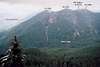
At about 4,600 ft there are some rock outcrops in the woods that are easily negotiated and don't pose an exposure risk. The corner makes an imperceptible bend leftward to the northeast and becomes Wow's Southwest Ridge. Ascend easily to Pt. 5722 and your first good views. The north side of Pt. 5722 is cliffy. The rightside is mostly forest. Keep to the right and descend slightly to the rufus saddle beyond. You are now only 15 minutes from the top. At some point just before the top or even in the vicinity of Pt. 5722 you will see or come upon the path of the Boundary Trail Route making its way toward the summit.
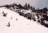
From the saddle keep going northeastward avoiding the open slopes on the right if there is an avalanche danger. A short, low-angle rock step will be encountered at about 5,800 ft. With fresh snow I easily dispatched it. There appears to be a bypass to its left up into the trees, so not to worry. Once past the step, arc up and left to the summit, which is the southmost point on the long North-South crest.
Mt. Rainier will now say hello...unless it's sleeping in a pillow of clouds like it was for me. I rang the bell but the pillows didn't stir.
Time = 2-3 hours; Gain = 2,900 ft; Distance = about 2 miles.
 |  |  |  |  |
Essential Gear
Sturdy bootsSpare socks in case you fall in the creek
Ice axe maybe for early season
Rain gear (this is Western Washington, after all)
mandrake - Jun 22, 2009 11:52 am - Voted 10/10
Goat CreekAscended via the Goat Creek approach in June 2009. The parking area was rather trashed with shotgun shells and garbage all over the place and other oddities like a fire-ring built right in the middle of the road (?); bizarre. From this trailhead it is also possible to ascend directly up the ridge to the south to join the approach as described via the Boundary Trail. We ascended that way and then came down the route as described here. Expect lots of thick brush along Goat Creek. The rest of the route is pretty vegetation free.