Approach
This is a 3800’+/- ascent day. After you reach the upper trailheads in Harvey Heights, there is no particular trail leading up to the northeast ridge. I have scaled this mountain twice and bushwhacked my way up to the ridge pretty much from where I was parked.
Study Squaws Tit well from the road before you enter Harvie Heights and take a compass reading.
Route Description
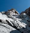
Angle northeast through the trees via your compass reading (stay off the trails as they lead nowhere you want to go). Once you break free of tree line at 7500’, look to gain the left hand skyline (northeast ridge) as soon as you can to avoid unrelenting scree. This ridge is nice and slabby offering great views the entire distance. Once up to the summit block, otherwise known as the "tit", traverse to the left (north side) and climb the crux to the summit. The first portion of this crux is multiple slabs.
If they are snow covered, your exposure is magnified considerably. Once above these slabs, you can climb straight up incurring several 5.7 moves or continue at an angle to first gain the southwest ridge at a weakness (saddle) and continue up from there. This second option of course makes for your best descent. Return is the same except, now you can descend some of that fast scree to the east of the ridge.
On my first ascent in May, I encountered tons of snow, so I went straight up on some 5.7 rock over serious exposure. The next year in April (with less snow), however, I could see the route was much more laid back via angling to a small saddle on the southwest ridge that makes for an easier ascent to the summit. I encountered no other climbers on either outing. Squaws Tit is much less ascended than its neighbors
Lady MacDonald,
Grotto, Ha Ling and Rundle. The view exposes the valley heading towards Banff to the south of Cascade Mountain, a full on frontal of the Mt. Rundle Traverse and a solid look at Mt. Assiniboine to the south.
Essential Gear
Helmet, Gaiters, Alpine Ax if Snow, Bear Spray, Compass

 5061 Hits
 73.06% Score
 3 Votes