
|
|
Route |
|---|---|
|
|
40.76800°N / 109.833°W |
|
|
Hiking, Scrambling |
|
|
Summer |
|
|
Half a day |
|
|
Class 2+ |
|
|
Route Map
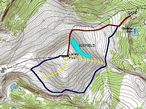 Red = North Ridge Route.
Getting There
From near the center of Vernal along Highway 40, turn north at the sign for Maeser and follow the road north to 500 North. Turn west here and follow 500 North to 3500 West. Turn north here. There is a sign for Red Cloud Loop Road. Follow the Red Cloud Loop Road through Dry Canyon. If you have time, make sure to stop at the pictographs and petroglyphs along the way.The road becomes a good gravel road at the Forest Service boundary. Follow the Red Cloud Loop all the way to a major junction with the road to Hacking Lake. A sign points the way to Hacking Lake, and follow the road to near Hacking Lake. Instead of turning left at the lake, follow the main road right and to its end. This is the trailhead.
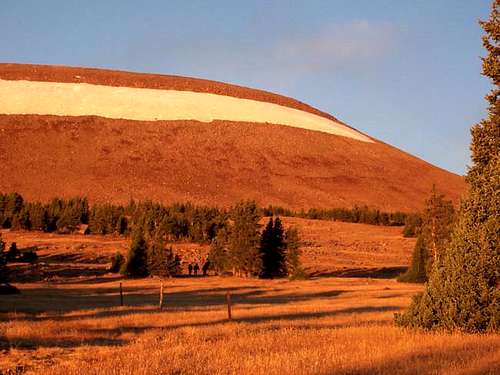
 In the fall, the drive to the trailhead is very colorful. September 28, 2005.
Route Description
This seems to be the fastest of all the routes to the summit of Leidy Peak. The route is fairly easy and has some nice views.From the trailhead and gate at 10,880 feet elevation, follow the trail/old road west. The trail divides shortly. Continue right on the old un-used road. After a short distance, notice the bench to the southwest. Leave the old road and climb up to this bench.
Once on the bench, traverse to the west and notice the north ridge of Leidy Peak which forms the right hand skyline of the peak and is just the right of the snow/icefield. Climb up on the ridge aiming for the right side of the icefield. The route is fairly steep, but the rock is stable up to the right side of the icefield.
Once you are at the icefield, continue up the slopes to the summit plateau. After the icefield, there is a section of boulder-hopping before the grassy slopes are reached, but if my 3-year old son could do it, so can you. Continue across the broad summit plateau to the summit which is marked with a large cairn.
The total distance to the top is only 1.7 miles one way and with about 1200 feet total elevation gain.
 Sunrise on the upper east slopes of Leidy Peak. The North Ridge forms the right hand skyline. October 1, 2005.
Essential Gear
A good pair of boots is needed.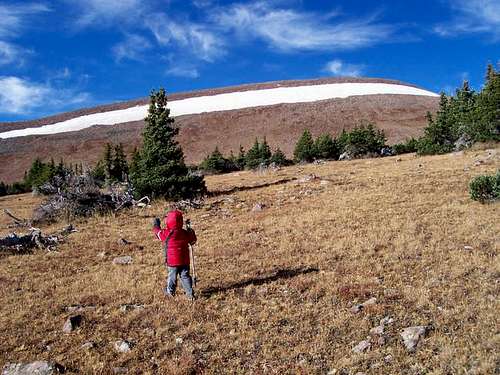 Approaching the northeast face of Leidy Peak. October 1, 2005.